Amazon - Website

 |
Project Gutenberg
Australia a treasure-trove of literature treasure found hidden with no evidence of ownership |
BROWSE the site for other works by this author (and our other authors) or SEARCH the entire site with Google Site Search |
Title: Northmost Australia, Volume II.


Author: Robert Logan Jack.


* A Project Gutenberg of Australia eBook *


eBook No.: 1303641h.html


Language: English


Date first posted: June 2006


Date most recently June 2013


Produced by: Col Choat and Ned Overton, with special thanks to Bob


Forsyth, who provided the Volume I. maps].


Production Notes: See below, at beginning of ebook.


Project Gutenberg Australia eBooks are created from printed editions


which are in the public domain in Australia, unless a copyright notice


is included. We do NOT keep any eBooks in compliance with a particular


paper edition.


Copyright laws are changing all over the world. Be sure to check the


copyright laws for your country before downloading or redistributing this


file.


This eBook is made available at no cost and with almost no restrictions


whatsoever. You may copy it, give it away or re-use it under the terms


of the Project Gutenberg Australia Licence which may be viewed online.
GO TO Project Gutenberg Australia HOME PAGE
Production Notes:
The present reformatted title is occasioned by recently
receiving all the maps belonging to Volume I., not previously
available. It incorporates the following changes:
* now as two separate volumes (like the original), each not so
bulky;
* all maps are referred to in each volume and are available for
each volume;
* better resolution maps may be had by clicking on the map in
this book to download;
* searchable [text] indexes of persons, localities and
subjects;
* numbers provided for pages beginning each chapter;
* better resolution illustrations, each located close to the
subject;
* improved readability by repositioning each footnote at the end
of the relevant paragraph.
* some of the punctuation has been modernised.
[The last three illustrations of Volume I. have been moved to this volume, where chapters on their subjects are found.]
Volume I. is available from Robert Logan Jack's listing at Project Gutenberg Australia.
NORTHMOST AUSTRALIA
WITH
A STUDY OF THE NARRATIVES OF ALL EXPLORERS BY SEA AND LAND IN THE
LIGHT OF MODERN CHARTING, MANY ORIGINAL OR HITHERTO UNPUBLISHED
DOCUMENTS, THIRTY-NINE ILLUSTRATIONS, AND SIXTEEN SPECIALLY
PREPARED MAPS
BY
LL.D., F.R.G.S., F.G.S., M.INST.M.M.
EX-GOVERNMENT GEOLOGIST,
QUEENSLAND, PREVIOUSLY OF THE GEOLOGICAL SURVEY OF SCOTLAND
AUTHOR OF
"HANDBOOK OF QUEENSLAND GEOLOGY"; "THE MINERAL WEALTH OF
QUEENSLAND";
"THE BACK BLOCKS OF CHINA," ETC.
AND JOINT-AUTHOR (WITH ROBERT ETHERIDGE, JUNIOR) OF
"THE GEOLOGY AND PALÆONTOLOGY OF QUEENSLAND AND NEW
GUINEA"
In Two Volumes
Vol. II.
| CHAPTER | |
| LI. |
Aboriginal and Polynesian Labour |
| LII. |
William Hann's Expedition, 1872: From
Fossilbrook, down the Lynd River and across the Tate and Walsh to
Leichhardt's Mitchell River |
| LIII. |
William Hann's Expedition, continued: Excursions in
the Valley of the Mitchell and the Relations of that River to the
Walsh and Lynd Rivers |
| LIV. |
William Hann's Expedition, continued: The Palmer River
and the Discovery of Gold |
| LV. |
William Hann's Expedition, continued: Palmer River to
Princess Charlotte Bay |
| LVI. |
William Hann's Expedition, 1872,
continued: The
Return Journey—Princess Charlotte Bay to the Mouth of the
Annan River—Cooktown |
| LVII. |
William Hann's Expedition, continued: The Return
Journey—Annan, Blomfield and Daintree Rivers |
| LVIII. |
William Hann's Expedition, continued: The Return
Journey—From the Daintree River to Fossil Brook |
| LIX. |
Mulligan's First Palmer Expedition, 1873,
and the Discovery of Payable Gold |
| LX. |
Dalrymple's Expedition, 1873—The
Beginnings of Cooktown and the First Rush from Cooktown to the
Palmer |
| LXI. |
Mulligan's Second Palmer Expedition,
1874—From The Palmer to the Junction of the St. George and
Mitchell Rivers, and Back |
| LXII. |
Mulligan's Third Expedition, 1874—From
the Palmer to the Walsh |
| LXIII. |
Mulligan's Fourth Expedition, 1874—St.
George and McLeod Rivers and the Heads of the Normanby and
Palmer |
| LXIV. |
Mulligan's Fifth Expedition,
1875—Cooktown to Junction Creek |
| LXV. |
Mulligan's Fifth Expedition, 1875,
continued:
Junction Creek to the Coleman River and Cooktown—Sixth
Expedition and Discovery of the Hodgkinson Goldfield |
| LXVI. |
The Coen Goldfield and its Prospectors,
1876-8 |
| LXVII. |
The Author's Explorations,
1879-80—Introductory and Explanatory |
| LXVIII. |
The Author's Explorations, 1879-80,
continued:
First Expedition—Cooktown to Coen Diggings and the Archer
River, and Back To Cooktown, 1879 |
| LXIX. |
The Author's Explorations, 1879-80,
continued:
Second Expedition—With Crosbie's Prospecting
Party—Cooktown to the Archer River |
| LXX. |
The Author's Explorations, 1879-80,
continued:
Second Expedition, continued: With Crosbie's
Prospecting Party—Across the McIlwraith Range from the
Archer River to the Nisbet River |
| LXXI. |
The Author's Explorations, 1879-80,
continued:
Second Expedition, continued: With Crosbie's
Prospecting Party—The Nisbet and Lockhart Rivers and Hays
Creek |
| LXXII. |
The Author's Explorations, 1879-80,
continued:
Second Expedition, continued: With Crosbie's
Prospecting Party—From the Lockhart River, across the
McIlwraith Range to the Pascoe River |
| LXXIII. |
The Author's Explorations, 1879-80,
continued:
Second Expedition, continued: With Crosbie's
Prospecting Party—From the Pascoe River to Temple Bay
(Opposite Piper Island Lightship) |
| LXXIV. |
The Author's Explorations, 1879-80,
continued:
Second Expedition, continued: With Crosbie's
Prospecting Party—"First Preliminary Report," A Summary of
Operations between Cooktown and Temple Bay |
| LXXV. |
The Author's Explorations, 1879-80,
continued:
Second Expedition, continued: With Crosbie's
Prospecting Party—From Temple Bay, through the "Bad Lands"
Or "Wet Desert", to the Head of the Jardine River |
| LXXVI. |
The Author's Explorations, 1879-80,
continued:
Second Expedition, continued: With Crosbie's
Prospecting Party—From the Head of the Jardine River, by
the Pacific Coast, to False Orford Ness |
| LXXVII. |
The Author's Explorations, 1879-80,
continued:
Second Expedition, continued: With Crosbie's
Prospecting Party—"Second Preliminary Report," A Summary of
Events from Temple Bay to False Orford Ness |
| LXXVIII. |
The Author's Explorations, 1879-80,
continued: With
Crosbie's Prospecting Party—From False Orford Ness to
Somerset |
| LXXIX. |
The Author's Explorations, 1879-80,
continued: With
Crosbie's Prospecting Party—"Third Preliminary Report," A
Summary of Events from False Orford Ness to Somerset |
| LXXX. |
The Author's Explorations, 1879-80,
continued: An
Afterword |
| LXXXI. |
Donald Laing—A Prospecting Expedition
in the McIlwraith Range, 1879-80 |
| LXXXII. |
J.T. Embley's Explorations and
Surveys—I. Expedition from the Hann River to the Gulf and
Back to the (South) Coen, 1884 |
| LXXXIII. |
J.T. Embley's Explorations and Surveys,
continued: II.
The Princess Charlotte Bay Rivers, Etc., 1883-5 |
| LXXXIV. |
J.T. Embley's Explorations and Surveys,
continued: III.
East Coast Rivers North of the Rocky River Goldfield |
| LXXXV. |
J.T. Embley's Explorations and Surveys,
continued: IV.
The Western Rivers of the Peninsula |
| LXXXVI. |
J.T. Embley's Explorations and Surveys,
continued: V.
The Southern Gulf Rivers |
| LXXXVII. |
J.T. Embley's Explorations and Surveys,
continued: VI.
The Cape York District |
| LXXXVIII. |
The Cape York Telegraph Line,
1883-7—Bradford's Preliminary Exploration—Surveys
during Construction |
| LXXXIX. |
Missionary Explorations |
| XC. |
Minutiæ of Marine Surveys—H.M.S.
"Paluma", 1890-4 |
| XCI. |
Minutiæ Of Marine Surveys,
continued:
H.M.S. "Paluma" and the Janet Range, 1890-3 |
| XCII. |
Minutiæ of Marine Surveys,
continued:
H.M.S. "Dart" and the Macrossan Range, 1896-8 |
| XCIII. |
William Baird, 1887-96 |
| XCIV. |
John Dickie, 1887-1920 |
| XCV. |
Dickie, Dick and Sheffield in the McIlwraith
and Macrossan Ranges, 1910 |
| XCVI. |
William Lakeland, 1876-1910 |
| XCVII. |
William Bowden, 1892-1901 |
| XCVIII. |
Aboriginal Prospecting—Pluto and the
Batavia River, 1910-16 |
| XCIX. |
Conclusion |
[The first three illustrations [originally from Volume I.] are now found here.]
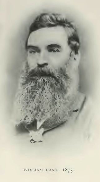
William Hann,
1873
Reproduced from Photo, lent by his daughter Mrs.
Charles Clarke, Maryvale.
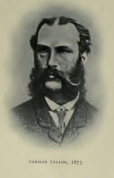
Norman Taylor,
1873
Reproduced from Dunn's Founders of the
Geological Survey of Victoria.
Thomas Tate, 25 June,
1913 (71st Birthday)
Reproduced from Photo, lent by his daughter Mrs.
Leake, Maxwellton, Queensland.
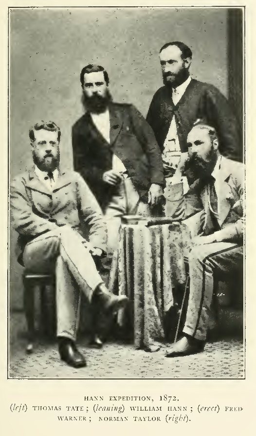
Hann Expedition,
1872: (left) Thomas Tate; (leaning) William Hann; (erect)
Fred Warner; Norman Taylor (right)
Reproduced from Photo, lent by Mrs.
Leake.
George Elphinstone
Dalrymple, 1876
Reproduced from Feldheim's Brisbane Old and
New.
William J. Webb,
1916
Reproduced from Photo, lent by
himself.
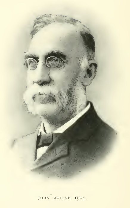
John Moffat,
1904
Reproduced from Photo, lent by his daughter Miss
E. L. Moffat.
James Venture
Mulligan, 1905
Photo. Poulsen, Brisbane, lent by T. J. Byers,
Hughenden.
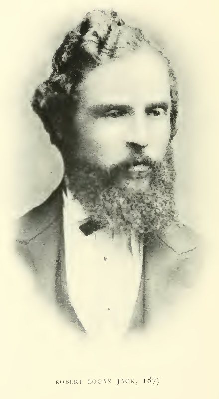
Robert Logan Jack,
1877
Photo. McKenzie, Paisley.
Benjamin Neave Peach,
1877
Photo. Bowman, Glasgow.
James Crosbie,
1891
Reproduced from Photo, lent by Mrs.
Crosbie.
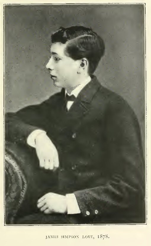
James Simpson Love,
1878
Photo. Munro, Edinburgh.
James Simpson Love,
1920
Photo. Bernice Agar, Sydney.
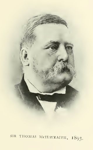
Sir Thomas McIlwraith,
1893
Photo, lent by Hugh Macintosh,
Brisbane.
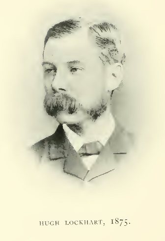
Hugh Lockhart,
1875
Photo. Moffat, Edinburgh.
Edward Hull,
1869
Photo. A. G. Tod, Cheltenham.
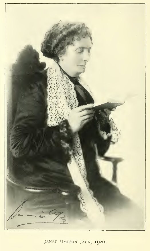
Janet Simpson Jack,
1920
Photo. Bernice Agar, Sydney.
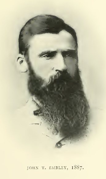
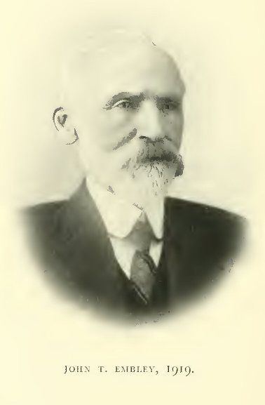
John T. Embley,
1887
Photo. Turtle & Co.
John T. Embley,
1919
Photo. J. Ward Symons.
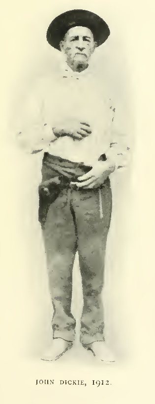
John Dickie,
1912
Reproduced from Photo, lent by W. J.
Webb.
James Dick,
1910
Reproduced from Photo, lent by W. J.
Webb.
[Note: All images of maps are at the end; back or bookmark to resume; click to enlarge. All of the maps found in the back pocket of the hard copy of Volume I are referred to in Volume II; hence, they are included here, with links.]
A. Cape York to New Guinea = Queensland 4-mile Map, Sheet 21B, with Additions from Admiralty Charts. Shows Sea Routes of "San Pedro" (Torres), 1606; "Duyfken" (Janszoon), 1606; "Pera" (Carstenszoon and Sluijs) and "Aernem" (Von Coolsteerdt), 1623; "Limmen" (Tasman), 1643; "Rijder" (Gonzal), 1756; "Buijs" (Asschens), 1756; "Endeavour" (Cook), 1770; "Bounty's" Launch (Bligh), 1789; "Pandora" and Her Boats (Edwards), 1791; "Providence" (Bligh) and "Assistant" (Portlock), 1792; "Hormuzeer" (Bampton) and "Chesterfield" (Alt), 1793 "Investigator" (Flinders), 1802; "Cumberland" (Flinders), 1803; "Mermaid" (King), 1818; "Isabella" (Lewis), 1836; "Tigris" (Iggleston), 1836; "Astrolabe" and "Mee" (Dumont-d'Urville), 1840; "Fly" (Blackwood), "Bramble" (Yule) and "Prince George," 1843-5; "Rattlesnake" (Stanley), 1849 "Basilisk" (Moresby), 1871-3: and Land Routes of Kennedy and Jackey-Jackey, 1848; F. and A. Jardine, 1865; Jack, 1880; Bradford, 1883.
B. Orford Ness to Cape Weymouth and Vrilya Point to Albatross Bay = Queensland 4-mile Map, Sheet 21A, With Additions From Admiralty Charts. Shows Sea Routes Of "Duyfken", 1606; "Pera" And "Aernem", 1623; "Limmen", 1644; "Buijs", 1756; "Rijder", 1756; "Endeavour", 1770; "Bounty's" Launch, 1789; "Investigator", 1802; "Fly", "Bramble" And "Midge", 1843; "Rattlesnake" and "Bramble", 1848; "Ariel" (Dobson), 1848; "Freak" (Simpson) And Her Whaleboat, 1849: And Land Routes Of Kennedy, 1848; F. & A. Jardine, 1865; Jack, 1880; Pennefather, 1881; Bradford, 1883; Hey, 1895; Embley, 1897.
C. Lloyd Bay to Stewart River = Parts of Queensland 4-mile Maps 20C and 20D, with Additions from Admiralty Chart. Shows Sea Routes of "Endeavour", 1770; "Bounty's" Launch, 1789; "Bramble" (Yule), 1843; "Rattlesnake" and "Bramble", 1848; "Dart", 1896-8: and Land Routes of Kennedy, 1848; W. Hann, 1872; Jack, 1879-80; Bradford, 1883; Embley, 1884-96; Dickie, 1901; Dickie, Dick and Sheffield, 1910.
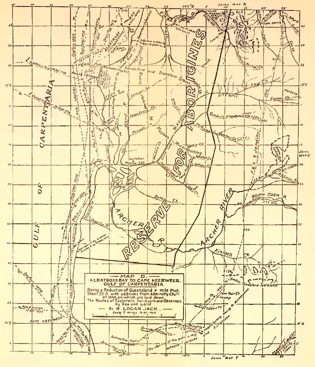
D. Albatross Bay to Cape Keerweer, Gulf of Carpentaria = Part of Queensland 4-mile Map, Sheet 20D, with Additions from Admiralty Chart. Shows Sea Routes of "Duyfken", 1606; "Pera" and "Aernem", 1623; "Limmen" (Tasman), 1644; "Buijs", 1756; "Rijder", 1756; "Investigator" (Flinders), 1802: and Land Routes of F. and A. Jardine, 1864-5; Embley, 1884-95; Hey, 1892-1919; Meston, 1896; Jackson, 1902.
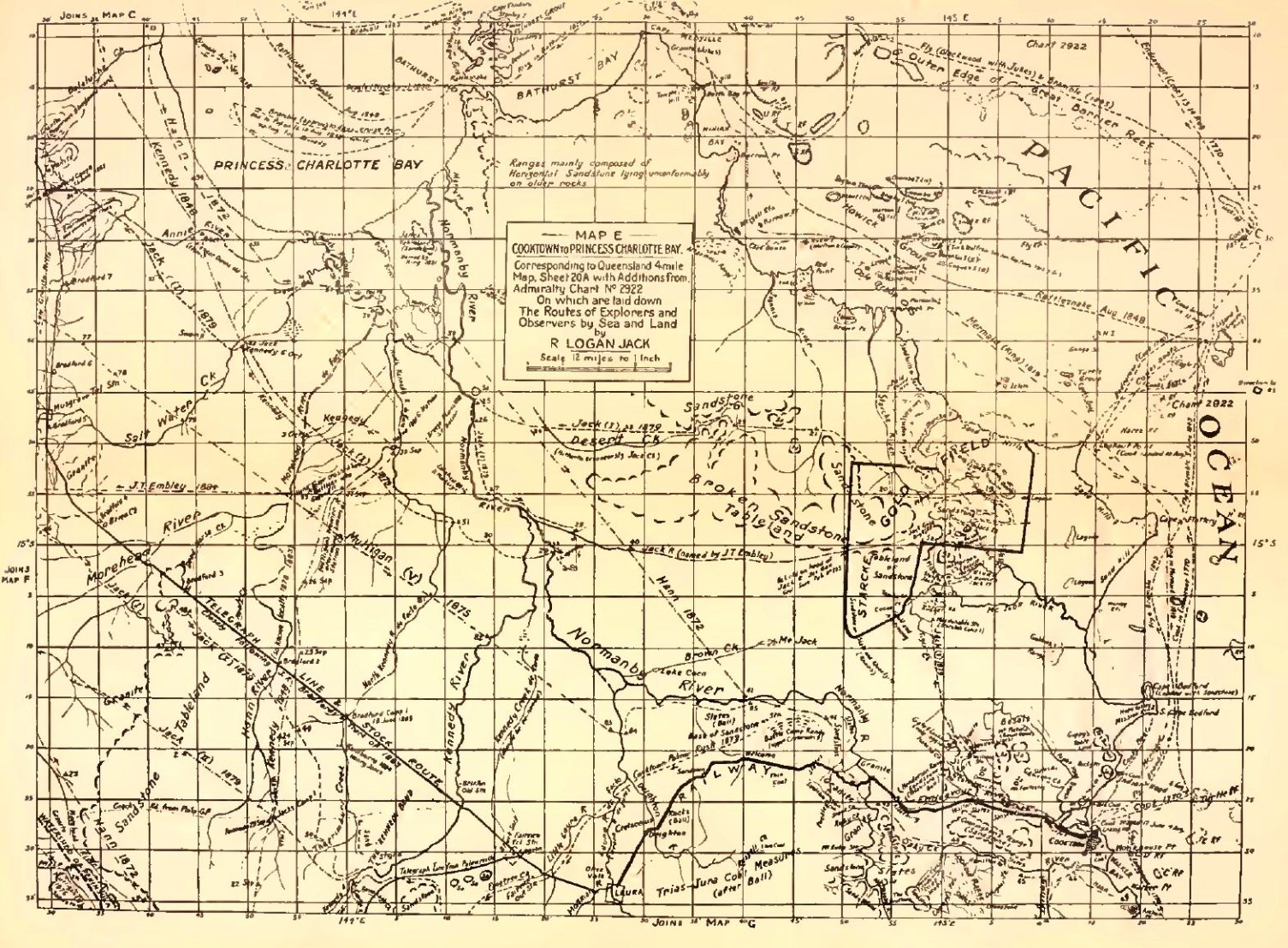
E. Cooktown to Princess Charlotte Bay = Queensland 4-mile Map, Sheet 20A, with Additions from Admiralty Charts. Shows Sea Routes of "Endeavour" (Cook), 1770; "Mermaid" (King), 1819; "Bathurst" (King), 1821; "Fly" (Blackwood) And "Bramble" (Yule), 1843; "Rattlesnake" (Stanley) and "Bramble" (Yule), 1848; and Land Routes of Kennedy, 1848; Hann, 1872; Mulligan, 1875; Jack, 1879; Bradford, 1883; Embley, 1884.
F. Hamilton and Philp Goldfields and Westward to the Gulf of Carpentaria, with the Kendall, Holroyd, Edward, Coleman and Mitchell Rivers = Queensland 4-mile Map, Sheet 20B, with Additions from Admiralty Chart. Shows Sea Routes of "Pera" and "Aernem", 1623; "Limmen" (Tasman), 1644; "Investigator" (Flinders), 1802: and Land Routes of F. and A. Jardine, 1864; Hann, 1872; Mulligan, 1875-95; Jack, 1879-80; Embley, 1874-1896; Bradford, 1883; Dickie, 1901.
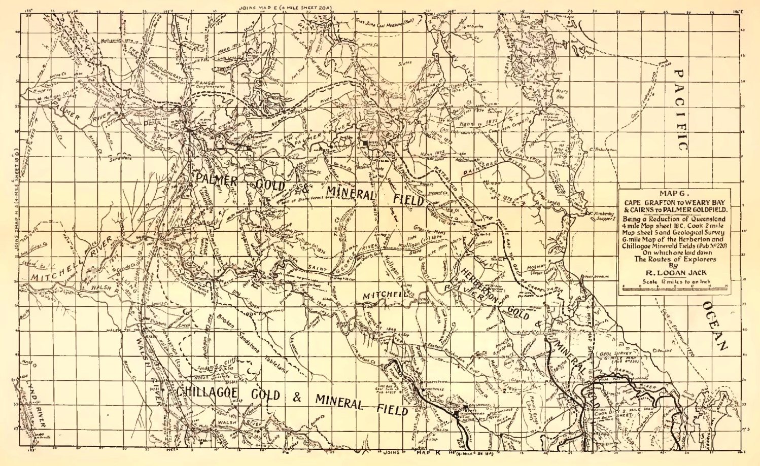
G. Cape Grafton to Weary Bay and Cairns to Palmer River = Queensland 4-mile Map 18C and Part of 18D, with Additions from Admiralty Chart. Shows Sea Route of "Endeavour" (Cook), 1770: and Land Routes of Leichhardt, 1845; Kennedy, 1848; Hann, 1872; Mulligan, 1873-75; Dickie, 1901.
H. Palmer, Mitchell, Lynd, Staten and Gilbert Rivers, and Part of the Gulf of Carpentaria = Queensland 4-mile Map, Sheet 18D and Part of 19C, with Additions from Admiralty Charts. Shows Sea Routes Of "Pera" and "Aernem" 1623; "Limmen" (Tasman), 1644; "Beagle" (Stokes), 1841: and Land Routes of Leichhardt, 1845; F. and A. Jardine, 1864; Hann, 1872; Mulligan, 1875; Embley, 1884-7; Dickie, 1891.
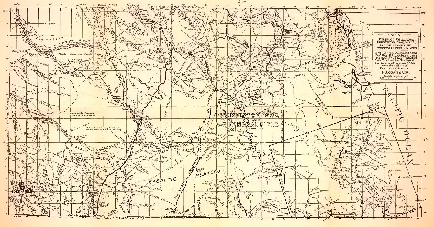
K. Etheridge, Chillagoe, Herberton, Cardwell and the Heads of the Herbert and Burdekin Rivers = Queensland 4-mile Map 18A, 2-mile Map of Cook District, Sheets 5 And 6, And 2-mile Map of Kennedy District, Sheet 9. Shows Land Routes of Leichhardt, 1845; Kennedy, 1848; Hann, 1872; Mulligan, 1873-75.
L. Croydon and Part of Etheridge Goldfields, the Gilbert, Etheridge and Einasleigh Rivers and the Head of the so-called Staaten River = Queensland 4-mile Map, Sheet 18B. Shows Land Routes of Gregory, 1856; McKinlay, 1862; F. And A. Jardine, 1864; Macdonald, 1864.
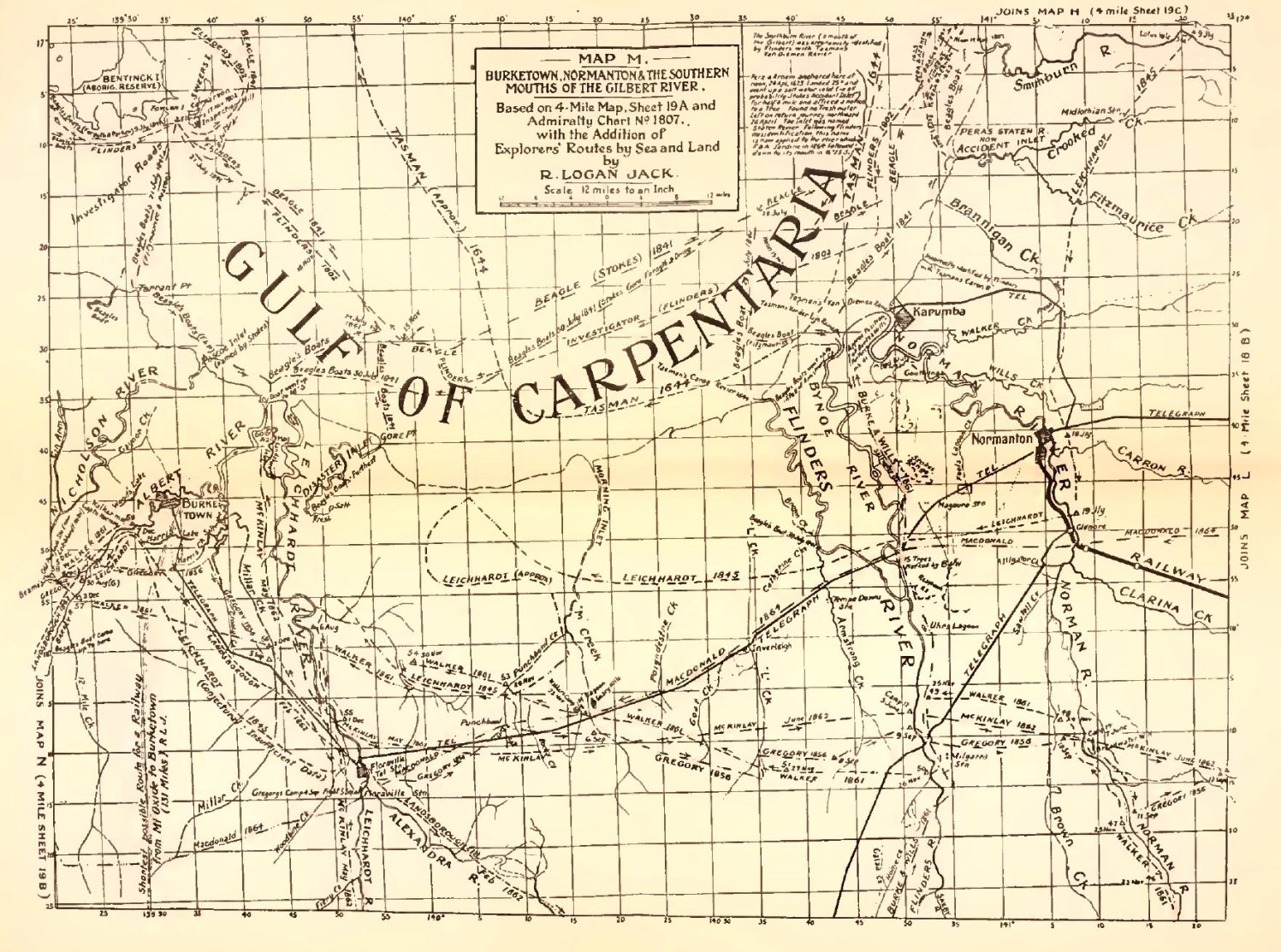
M. Burketown, Normanton and the Southern Mouths of the Gilbert River = Queensland 4-mile Map, Sheet 19A, with Additions from Admiralty Charts. Shows Sea Routes of "Pera" And "Aernem", 1623; "Limmen" (Tasman), 1644; "Investigator" (Flinders), 1802; "Beagle" (Stokes) and her Boats, 1841: and Land Routes of Leichhardt, 1845; Gregory, 1856; Burke and Wills, 1861; Walker, 1861; Landsborough, 1862; McKinlay, 1862; Macdonald, 1864.
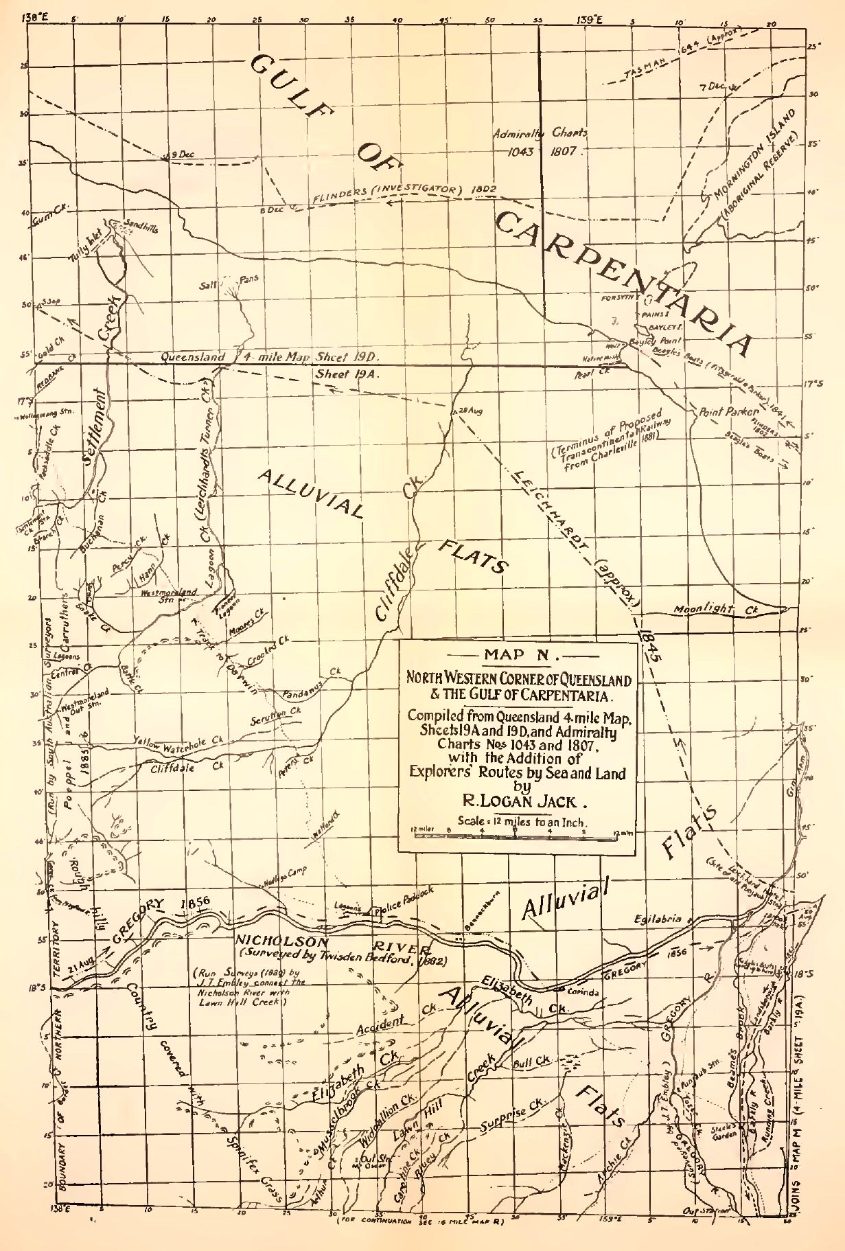
N. North Western Corner of Queensland, and the Gulf of Carpentaria = Queensland 4-mile Map, Sheet 19A and Part of 19D, with Additions from Admiralty Charts. Shows Sea Routes of "Limmen" (Tasman), 1644; "Investigator" (Flinders), 1802; "Beagle's" Boats, 1841: and Land Routes of Leichhardt, 1845; Gregory, 1856; Landsborough, 1861; Bedford, 1882; Embley, 1889.
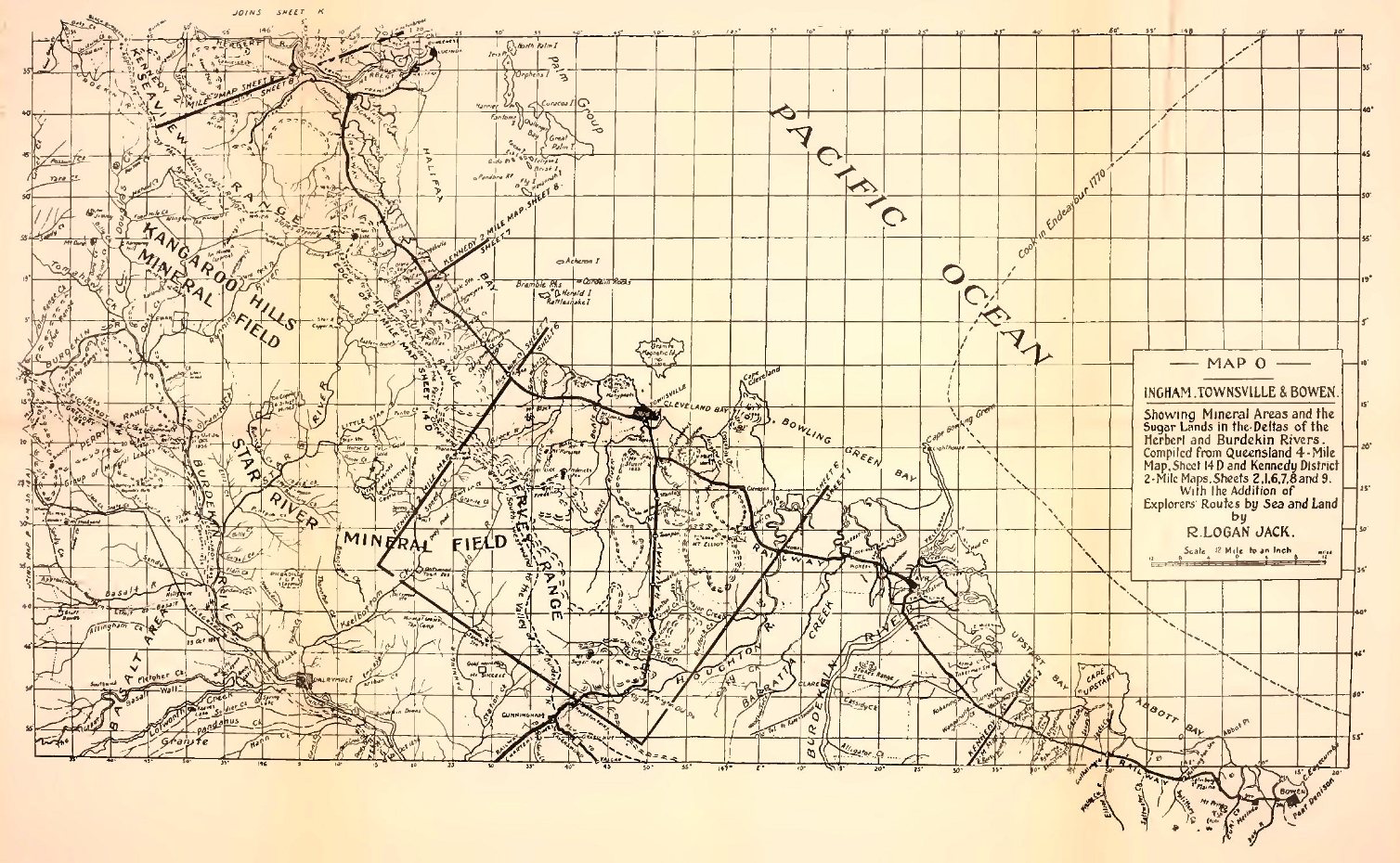
O. Ingham, Townsville and Bowen, and Deltas of Herbert and Burdekin Rivers = Queensland 4-mile Map, Sheet 14D and Kennedy District 2-mile Map, Sheets, 1, 2, 6, 7, 8 and 9. Shows Sea Route of "Endeavour" (Cook), 1770: and Land Routes Of Leichhardt, 1845; Gregory, 1856.
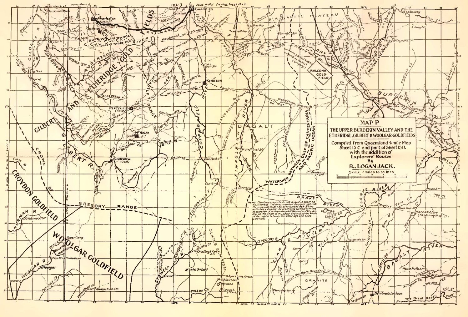
P. The Upper Burdekin Valley and the Etheridge, Gilbert and Woolgar Goldfields = Queensland 4-mile Map, Sheet 15C and Part of 15D. Shows Land Routes of Leichhardt, 1845; Gregory, 1856; McKinlay, 1862; Macdonald, 1864; Daintree, 1864-9.
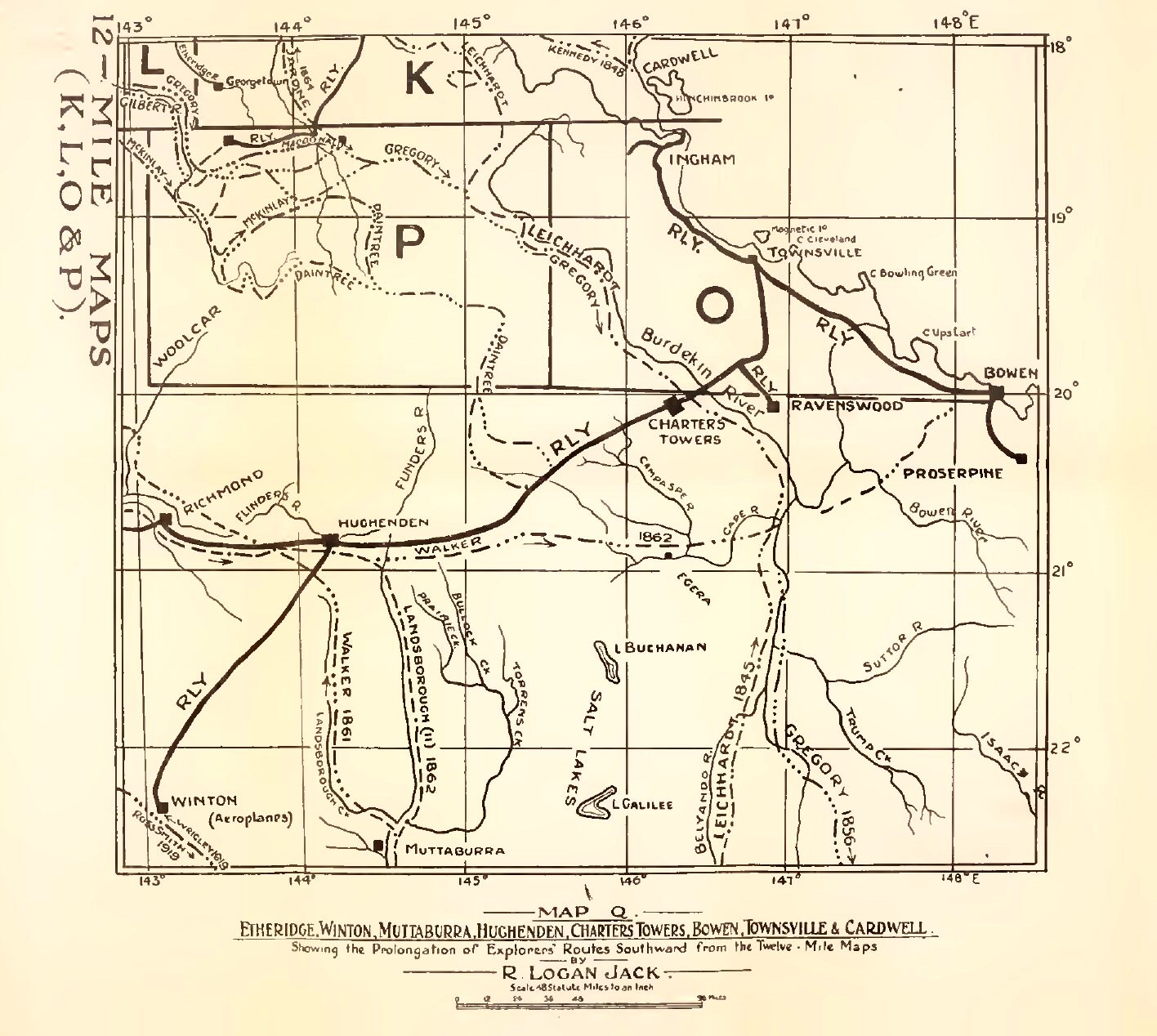
Q. Cardwell, Townsville, Bowen, Winton, etc., Including Maps O and P, Parts of K and L, And Queensland 4-mile Maps 14B, 15A, 10D, 11C, and Parts of 14A, 15B, 15D, 10C And 11D. Shows Land Routes of Leichhardt, 1845; Kennedy, 1848; F. and A. Jardine, 1864; Gregory, 1856; Walker, 1861; McKinlay, 1862; Walker, 1862; Landsborough, 1862; Macdonald, 1864; Daintree, 1863-70; Wrigley (Aeroplane), 1919; Ross-Smith (Aeroplane), 1919.
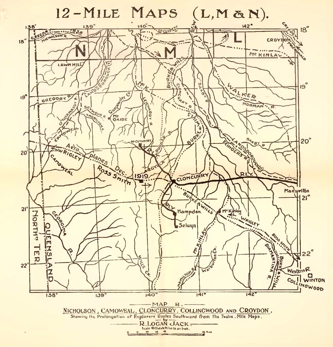
R. Camooweal, Croydon, Mount Cuthbert, Cloncurry, Selwyn, Collingwood, Including Parts of L, M and N, Queensland 4-mile Maps, Sheets 16C, 16D, 16A, 16B, 12C and 12D, and Parts of 15D, 15C and 11D. Shows Land Routes of Leichhardt, 1845; Gregory, 1856; Burke and Wills, 1861; Walker, 1861; Landsborough, 1862; McKinlay, 1862; Macdonald, 1864; Jack, 1881; Wrigley (Aeroplane), 1919; Ross-Smith (Aeroplane), 1919.
[INDEX of MAPS for VOLUMES I and II.
Click map to view larger image.]
{Page 367}
NORTHMOST AUSTRALIA
Pearling and Bêche de Mer Industries. Early Unrestricted Traffic in Labour. Kidnapping and other Abuses. Strict Supervision a Necessity. Legislation successfully employed. Different Classes of Workmen required in Sugar Industry. Recruiting of Labour. Length of Service and Payment and Treatment of Labourers Regulated almost from the First. Growing Objection to Imported Black Labour. The "White Australia" Ideal. Abolition of Coloured Labour and Repatriation of Islanders. In Any Case, the Islands cannot supply a Sufficient Number of Labourers. Not even Labourers enough for Plantations established in the Islands. Literature Pro and Con.
THE political and economic questions involved in the employment of aborigines and South Sea Islanders are, strictly speaking, beyond the scope of this work; but certain reflections inevitably arise. What I have to say on the matter is based partly on observations made and impressions formed in the course of official journeys which took me from time to time among the sugar plantations of Northern Queensland, and still more on an extensive perusal of the literature of the subject, and especially of the books and pamphlets enumerated in the footnote. [1]
[1) ACTS AND REGULATIONS
1862. Coolie Act (never operated).
1868. Polynesian Act. (Provides for Government Agent on recruiting ships.)
1872. (Imperial) Pacific Islanders' Protection Act (vulg. "Kidnapping Act"). (Labour vessels must be licensed. Onus of proof of labourers' consent. Kidnapping penal.)
1875. (Imperial) Pacific Islanders' Protection Act.
1879. Queensland Regulations. (No fire-arms nor liquor to be sold by traders. No presents to "friends" of labourers.)
1880. Pacific Island Labourers Act. (Repeals 1868 Act and re-enacts its provisions, with additions, e.g., hospitals, restriction of labour to tropical agriculture, and proof that labourers understood contract.)
1883. Pacific Island Labourers. (Inspectors in Queensland.)
1884. Native Labourers' Protection Act. (Service restricted to three years.)
1885. Act. Abolition of Island Labour. (No more labour to be imported or employed after 1890.)
1892. Pacific Island Labourers Act. (Repeals 1885 Act.)
BOOKS AND PAMPHLETS
Captain George Palmer, R.N.,F.R.G.S., Kidnapping in the South Seas, being a Narrative of a Three Months' Cruise of H.M. Ship "Rosario." Edinburgh, 1871. (Alleges wholesale slaving and kidnapping. This is emphatically denied by Sir Charles Cowper, Agent-General for New South Wales, in The Times of 18th December, 1871. Sir Charles shows that Captain Palmer's case is based on his seizure, at Fiji, of the 44-ton ship "Daphne", owned in Victoria, licensed by the Queensland Government to carry fifty-eight islanders, which was claimed by Captain Palmer as a prize and sent to Sydney, New South Wales, for condemnation. Palmer's action was disapproved by his superior officer, Commodore Lambert, and his claim was rejected by the Court, on the evidence, whereupon he accused, among others, the Governor and Chief Justice of New South Wales, of partiality to slavers. Sir Charles remarks on "Captain Palmer's inability to understand what legal evidence was.")
"Labour Trade in the Western Pacific." New South Wales Blue Book, 1881. (Articles by Baron Miklouho Maclay and others on Kidnapping and Slavery in Western Pacific, Statistics of Vessels employed, etc., etc.)
J. Langdon Parsons, M.P., Minister for Education, South Australia. The Sugar Industry in the Mackay District . . . and the Advantages of Coolie Labour for the Northern Territory. Adelaide, Govt. Printer, 1883.
A. Mackenzie Cameron. On the Most Suitable Labour for Sugar Cultivation in Northern Queensland. Prize Essay, N.Q.P. & A. Ass. Townsville, 1883. (Argues that island labour is the only labour suitable for the industry.)
A. J. Duffield. What I know of the Labour Traffic, a Lecture, Brisbane, 1884. (The author, for the purpose of obtaining evidence against coloured labour, took service as Government agent on the Recruiter "Heath." He insists that it was a mere pretence that the islanders understood their contracts, alleges corruption of Government agents and argues that no recruiting vessel could make the trade pay without a "side line" of "trade" in worthless goods. Further alleges that "man-hunting" is an instinct which, if uncontrolled, will inevitably be indulged in; that Government interference is harmful whenever it is not evaded, and that there is great mortality among labourers on Queensland plantations. Regards Indian coolie labour as the solution of the question.)
J. Y. Walker in History of Bundaberg. Sydney and Bundaberg, 1890. "The Sugar Industry, which includes a Practical View of the Kanaka Question, submitted to the People and Parliament of Queensland by the Bundaberg Planters Association." (Argues in favour of island labour as the most suitable.)
W. T. Wawn. The South Sea Islanders and the Queensland Labour Trade: A Record of Voyages and Experiences in the Western Pacific (1875-91), by William T. Wawn, Master Mariner. London, Swan Sonnenschein & Co., 1893.
Rev. Alex. C. Smith, Convener of the Queensland Presbyterian Foreign Missions Committee. The Kanaka Labour Question, with Special Reference to Missionary Efforts in the Plantations of Queensland. Brisbane, Alex. Muir & Morcom, 1892. (Derides alleged high death-rate on plantations and claims that Christianising and civilising influences are brought to bear on the labourers.)
The Sugar Question in Queensland. A series of Papers published (in the interest of planters) by Watson & Ferguson, Brisbane, 1901. (Includes an article by The Times correspondent on the conditions attending small white holdings side by side with plantations employing island labour.)
Mackay Federal Tariff Committee. Report to Brisbane Chambers of Manufacturers, 17th September, 1900. (Claims that "Kanaka" labour is indispensable, but admits that it should be restricted to agriculture.)
The Sugar Industry: The Voice of Queensland Agricultural Societies. Brisbane, 1901. (Unanimous condemnation of proposed abolition of island labour.)
"The Sugar Industry: Conditions in Northern Queensland." Reprint of Articles in Rockhampton Daily Record, January, 1905. (Argues that island labourers form an insignificant proportion of total population and that, while they give employment to a large number ol whites, their expulsion would ruin the industry.)
Labour in Cane-fields Conference. Townsville, February, 1907.]
In the natural course of the development of Queensland, it so happened that two new industries required the services of labourers capable of working under tropical conditions on land and sea. On the one hand, there were the sugar planters, who needed gangs of cheap labourers possessing some knowledge of the principles and practice of agriculture. On the other hand, there were the "fishers" of pearl-shell and bêche de mer, whose requirements were more complex, and necessitated the grading of their hands according to their skill in diving, their capacity for handling boats, and their fitness for hard, rough and dirty work on schooners and curing stations.
The "fisheries" had room for a considerable number of labourers of the unskilled order. Queensland aborigines, Torres Strait Islanders of Papuan descent. South Sea Islanders, any or all of them could perform the duties of the rank and file employed in this industry. In the early days the absence of acts or regulations prescribing the period of service, the hours of work or the remuneration of the persons so employed left the employers—the party of the first part—free to make and enforce their own terms. Even if the captains of the industry had been willing to negotiate for service on fair conditions, their ignorance of the languages of the different tribes would, in most cases, have made it impossible for them to do so. Add to this the "contributory" condition that the party of the second part was often by nature and habit unversed in the art of chaffering and ignorant of values in time, money and merchandise, and it is not surprising that in many instances the party of the first part concluded that, "once on board the lugger", the party of the second part would prove amenable to reason and make such contracts as were suggested to him. It can easily be imagined that, however much the ultimate employer might desire to secure only willing labour, the interests of skippers, paid at so much per head, were all in favour of large numbers recruited by whatever inducements would fill up their vessels. Without rigorous naval supervision, abuses would appear to have been inevitable under such a system of recruiting. It is much to their credit that the majority of the skippers recruiting for Queensland employers did their best under very difficult conditions; but there were exceptional cases of cruelty and deception. Tales of wrongs and violence began to reach the world outside. Now and then a warship made a surprise visit to the scene of operations and executed justice at the discretion of the Commander and the Naval Court composed of his officers convened by him. The Parliament of Queensland made act after act for the regulation of the traffic and the protection of the aborigine and Polynesian, and an ex- Premier, the Hon. John Douglas, having been appointed Government Resident at Thursday Island, was entrusted with the institution and conduct of a system of marine patrolling. It may be conceded that the information on which the official supervisors of the fisheries had to act on their own responsibility, was often difficult to bring into line with the principles regulating admissible legal evidence; but, on the other hand, there can be no doubt that Mr. Douglas and his successors did their best to administer even-handed justice of a rough and ready sort. The principles of this administration were obviously modelled on those followed from time immemorial by the Royal Navy in dealing with savages when interference became unavoidable.
Under the (Imperial) Pacific Islanders' Protection Acts of 1872 and 1875, naval officers were entrusted with formidable powers, to be used at their discretion and on their own responsibility. Naval interference, as a rule, amounted to a demonstration that an irresistible power was to be reckoned with by white men or black who overstepped the bounds of fair dealing or resorted to violence.
After some chaotic years, the Government managed to regulate the labour traffic for the fisheries in matters affecting recruiting licences, term of service, remuneration and other conditions, and the industry then settled down satisfactorily into working order.
Captain Moresby, as we have already observed, appeared on the scene in a period of transition. New Colonial legislation regarding licences to recruit had just come into force, and such of the recruiters of labour and employers as had heard of them, had suspended operations and were waiting for licences, while others had not even heard of them. In such circumstances, action of a very tactful nature was obviously demanded, but Moresby was enthusiastic and zealous, and treated as a slaver, and therefore a lawful prize, every ship on which an islander could be found who complained that he had been misled as to the term of service (although the offence might have been committed before there was any law on the subject). It need only be said that the courts of appeal did not support his view of the justice of retrospective penalties. The wording of the 1872 Act, forbidding ships to carry unlicensed labourers "except the crew", it seems to me, left room for an elastic interpretation of the word "crew". In a passenger or cargo vessel the crew may be defined as the men necessary to make it go; but in a fishing-boat which is also a fish-curing factory the definition may be stretched to the point of absurdity.
The foreign skilled labour employed in the "fisheries"—more and more in demand as deeper diving became necessary—has always been furnished by the justly self-respecting natives of Japan and the Malay Peninsula, who are not less expert in the making and the legal enforcement of bargains than in deep diving, and may be trusted to safeguard their own interests.
The sugar industry had no need for aboriginal labour, except during the initial operation of clearing the land; and the ring-barking and felling of trees, especially when the natives were supplied with steel axes—new toys with which it was a pleasure to work, when contrasted with their own stone implements—was light labour, made lighter still by the zest of destructiveness, and exactly suited to their temperament. The planters had no difficulty with them, and already the only terms on which the aborigines would work were well understood. The planter practically said to the local tribesmen: "Come when you like. For a certain number of trees barked, felled or grubbed, you will get enough blankets, clothing, flour, meat, tea and tobacco, and a little money for yourselves and a fair number of your hangers-on. Go when you are tired of it, and come back when you feel inclined." Later on, the actual planting and culture of the cane demanded a more intelligent and reliable class of field labourers, who had to be paid at a rate which would not disqualify the planter for competition with employers of coloured labour in the same business elsewhere. For the supply of this labour the islands of Polynesia formed the only recruiting ground available. The cultivation of large areas of cane entailed, ultimately, the employment of numbers of skilled and highly paid white artisans in crushing and refining.
Recruiting among the islands for field labour in tropical agriculture began practically in 1875, by which time there were nearly 13,000 acres under cane. The traffic was almost from the first subject to the provisions of the Imperial Pacific Islanders' Protection Acts of 1872 and 1875. From 1879, Colonial legislation provided, as the necessity for each became apparent, strict regulations regarding rationing, housing, payment, medical attendance, term of service, return of the labourers to their proper islands, the supervision of recruiters by Government agents on board the vessels and the protection of labourers by inspectors in the agricultural districts.
In the ninth decade of the nineteenth century the idea of a White Australia had captured the democratic electorates of Queensland. The aborigine, in whose possession an inexplicable, but inexcusable, blunder on the part of the Creator had placed the Australian continent before white men "discovered" it, was negligible because he was dying out in obedience to a law of nature, but, at all events, the immigrant black man must go. There was no place for him in a Utopia where a limitless wages-fund—accumulated in the hands of capitalists and ipso facto wrongfully accumulated—awaited distribution among a restricted number of white workers. It was in vain that the capitalist remonstrated that the proposed action would put an end to the industry and ruin those who had invested their all in it, for the labour logician was ready with his answer: "That is your affair; no industry that cannot afford to pay the workers the wages they require has any right to live."
White Labour made an outcry about the poor blacks kidnapped and enslaved, and the object of the outcry was evident. The impartial observer need make no mistake about it. To White Labour, the black man is not a suffering brother, but a noxious animal, no more and no less. But the cry of "blackbirding" was sufficient to rally the force known as "Exeter Hall."
It may be taken for granted that among the earlier labour recruits there were many who had no clear idea of the term for which they were to serve or the remuneration they were to receive. But it was very different with those who recruited after having had the opportunity of conversing with the returned boys of the first fleet, who had travelled and seen the world and returned to their homes the envied possessors of tangible riches in the form of European wares. Indeed, many of the first fleet boys, like Byron's "restless spirit", soon got "sated of home", and took the first opportunity of returning to the plantations.
On the plantations themselves, I had many opportunities of observing the gangs of field labourers, and, in my opinion, they were fairly happy and contented, and took a pride in their work. They even imbibed some Christianity, no doubt of a crude order, suited to their comprehension. On this point the evidence of the Rev. A. C. Smith, Convener of the Presbyterian Foreign Missions Committee, is significant, and I should suppose him to be a sufficiently respectable and responsible authority.
As regards recruiting and its abuses, the reader who desires to pursue the subject further may profitably peruse the whole of the literature referred to in the footnote, and especially {contra) Palmer's Kidnapping in the South Seas, and Duffield's Labour Traffic (also Moresby, as in the two preceding chapters), and (pro) Wawn's The South Sea Islanders and the Queensland Labour Trade. This Captain was engaged in recruiting for practically the whole of the period during which it was practised. He declares emphatically that he never engaged in kidnapping and never saw it, but suspected that some other parties might have been guilty. He depicts the growing difficulties of the traffic under fresh enactments—one of Duffield's "points"—for instance that, whereas others might send out punitory expeditions to avenge island murders, it became at length "a hanging matter" for the recruiter to defend himself against treacherous attacks by natives, as in the words of the old adage, "one man may steal a horse while another is hanged for looking over a wall." The gist of Wawn's argument is summed up in his dedication, which is as follows:—
"To the Sugar Planters of Queensland, who have spent the best years of their lives and millions of money in developing an Industry which represents not less than Ninety per cent, of the total Agricultural value of that Colony; and which at one time bade fair to eclipse even the great Pastoral and Mining Industries in wealth and importance: To those Bold Pioneers who have opened up the rich pastoral districts along the Coast, and have been the means of settling thousands of Europeans on the Land; and who have done more towards the practical civilisation of the Cannibal and the Savage than all the well-intentioned but narrow-minded enthusiasts of the Southern Pacific: To those Good Men and True who, after a quarter of a Century of hard work and doubtful prosperity, have been basely betrayed and unscrupulously sacrificed to the greed of the political place-hunter and the howling ignorance which follows in his train—I dedicate this work, with much sympathy and respect."
In 1885 it was decreed that within five years all Polynesians should be returned to their homes and that from the passing of the Act no more should be landed in Queensland. Repatriation commenced forthwith, but it was complicated, embittered and delayed by a number of circumstances, chief among which was the question of fire-arms. The sale of firearms to the islanders in Queensland had been forbidden in 1879, as was also the trade in fire-arms at the islands. The sole effect of the latter regulation was to hand this "trade" to French and Germans. Then, again, a number of "boys" who had completed their contracts in Queensland had bought and paid for cheap guns, and these were confiscated without compensation when the boys embarked on the return vessels.
The repatriation of the islanders by the end of 1890, the time prescribed by the Act of 1885, having been found to be incomplete, the Act was repealed in 1892, and the limit of deportation extended. A few years later the obnoxious islanders were finally cleared out of the country, some of them very unwillingly.
My conclusions are:—
(1) That the pearl and bêche de mer "fishers" in many instances wronged and oppressed the aborigines whom they induced to board their vessels, and that murders and reprisals resulted; that to a lesser extent they treated Torres Strait and Pacific Islanders in the same way; that these evils were in course of time successfully overcome by legislation and supervision, and that the industry is now as respectable a business as any other.
(2) That the sugar planters never did the aborigines the slightest harm.
(3) That their agents engaged in recruiting did occasionally employ methods for which they had neither authority from their employers nor any reason except their own cupidity, but that such irregularities were exceptional.
(4) That such irregular, unjust or outrageous conduct could be put an end to, and, in fact, was practically put an end to, by legislation and supervision.
(5) That the South Sea Islanders were, and are, the best labourers in the cane-fields.
(6) That the islanders brought to Queensland were well treated on the plantations, liked their work, and in many instances voluntarily renewed their term of service on the completion of their contracts.
(7) That the whole generation of pioneer planters was financially ruined by the stoppage of the labour on the faith of the continuation of which they had spent their capital.
(8) That South Sea Island labour could, after all, only have served to keep the industry going during its early years, because of the insufficiency of the supply. At the present day cane growers establish plantations on the islands of the Pacific, and already find that the population cannot furnish the number of labourers demanded by a progressive industry, however suited for it the conditions of soil and climate may be.
(9) That Queensland is irrevocably committed to white labour, which, in spite of assertions to the contrary, is shy of field work in the tropics.
{Page 374}
Advance of Settlement since the Jardine Expedition. Aim of Hann's Expedition. Personnel and Equipment. Parallel Creek and Einasleigh River. Start from Fossilbrook. Camp I. Site of Modern Lyndbrook Railway Station. Down Lynd River. Camps 2 and 3. Hackett's Creek. Lynd River again. Camp 5. Kirchner Range. Prospecting for Gold. Pinnacle Creek. Camp 6. Tate River. Nonda Creek. Natives. Camps 7, 8 And 9. Walsh River. Camp 10. Excursion up the Valley. Hills of Magnetic Iron Ore. Natives. Main Journey resumed. Walsh River. Camp II. Fossils. An Area of Lower Cretaceous Rocks. Modern Telegraph Line at Camp 12. Elizabeth Creek. O.K. Copper Mine. Wrotham Park Cattle Station. Nolan Creek. Camp 13. Mitchell River. Camp 14.
THE seven years which followed the return of the Jardine Brothers' Expedition in 1865 witnessed the steady march of settlement in Northern Queensland. In 1865, Mackay and Townsville were opened as ports. A hardy and adventurous population had been drawn to the interior by the discovery of gold in widely separated localities, such as the Cape River (1868), the Gilbert and Percy Rivers (1869), Ravenswood (1870), Etheridge (1869-71) and Charters Towers (1872). With a view to the supply of the goldfields and ports with meat, and to the export of wool, numerous "squatters" spread out and occupied such tracts of country as were suitable, available and accessible.
In the usual course of events, the discovery and opening of the interior radiate inwards from the harbours of the coast. Townsville, however, formed an exception to this rule. Pastoral occupation, with Port Denison and the town of Bowen [1] as a base, had pushed out to the west of the Coast Range, and reached the Fanning and Burdekin valleys. The growing necessity for access to the coast at some point nearer than Bowen led to a lookout for a more convenient port. Early in 1864, J.M. Black (Managing Partner of R. Towns & Co. in the north) pointed out the claims of a site at the mouth of Ross Creek, and, in June of that year, organised a party who made it their business to connect the site with the squatting runs of the interior. (See MAP O.) In 1865, the port of Cleveland Bay was proclaimed, and the town of Townsville was founded. [2]
[1) In 1859, while the negotiations for the separation of Queensland from New South Wales were in progress, Captain H. D. Sinclair left Rockhampton in the "Santa Barbara" in search of a suitable harbour on the north-east coast. Port Denison was recommended by him. The township of Bowen, on the new port, was established in 1861.]
[2) Queensland; Its Territory, Climate and Products. By Richard Daintree, Agent- General. London, N.D. (circa 1873), p. 7.]
The Brothers William and Frank Hann, who had settled at Maryvale, on a branch of the Clarke River, a tributary of the Burdekin, had the honour of being the first to take wool to the new port for shipment. It may be mentioned that Townsville is now a "city" of nearly 28,000 inhabitants. It is also the starting point of a railway, through the sugar lands of the Lower Burdekin to the older town of Bowen, of another to the sugar lands at the mouth of the Herbert River (Ingham), and of a main trunk line through the Cloncurry Copper-field (480 miles) and Mount Cuthbert Copper Mine (70 miles), passing through Charters Towers Goldfield and the great pastoral centre of Hughenden, with a branch to Ravenswood Goldfield; and it must, at no distant date, reach the Gulf of Carpentaria.
The Brothers Hann early developed a passion for exploration, and their friendship and business connection with Richard Daintree had an influence in directing their energies. The achievement of the elder brother, William, who died in the eighties, alone comes within the province of this investigation, but it may be noted that the younger brother, Frank, during a long and adventurous life, has added greatly to our knowledge of the interior of Australia, from the east coast to the west, and until quite recently was still active in exploring the less known lands on the borders of Western Australia, South Australia and the Northern Territory.
William Hann's expedition was, to some extent, assisted by the Government, and had for its object "ascertaining, as far north as the 14th parallel of latitude, the character of the country and its mineral resources, with the view to future settlement and occupation." Its members were William Hann [1] (Leader), Norman Taylor, formerly of the Geological Survey of Victoria (Geologist), Thomas Tate (Botanist), [2] Frederick Warner (Surveyor), Stewart, William Nation, [3] and Jerry, an aboriginal.
[1) Born in Wiltshire, England, 26th February, 1837.]
[2) Tate (born 25th June, 1842) was one of the survivors of the wreck of the "Maria" brig, bound for New Guinea with a number of gold prospectors. Having previously been a medical student, he was rated on the ship's books as Acting Surgeon, and was generally known as Dr. Tate. He landed at Cardwell in charge of one of the "Maria's" boats in March, 1872.]
[3) Nation left Maryvale station on 1st September, 1873, as a volunteer member of George de Lautour's party, with cattle for Port Darwin. Fifty-four miles past the Nicholson River, a disagreement with de Lautour led to Nation and Leonard Elvoy leaving the party. Having encountered floods and other difficulties, they were soon reduced to the brink of starvation, and had killed all their horses but one for food. From a camp near the Roper River, in the Northern Territory, Elvoy rode (150 miles SW.) to Daly Waters Telegraph Station, to seek relief for Nation. Under instructions from Adelaide, R. R. Nuckey, an Overseer of the Overland Telegraph Construction party, promptly set out to the rescue, accompanied by de Lautour, who by this time had arrived, minus his cattle. On 12th June, 1874, Nation's remains were found at the camp where Elvoy had left him. He appeared to have been dead about ten days. Nation Range and Nation River were named to mark the scene of the tragedy.]
Of William Hann's abilities as a bushman there can be no question. His courage was only kept in check by his sound judgment. On the other hand, he was sometimes petulant and sometimes overbearing in manner, and, in a word, was not "easy to get on with". He himself confesses to occasional loss of temper and injustice done to his subordinates in the heat of the moment. No doubt the temper of an angel would be tried at times by the alternating hardships and ennui of a long exploring expedition. Hann definitely charges Taylor with two acts of reprehensible carelessness of the safety of the horses and Tate with a want of consideration for the other members of the party. It is obvious that both of these gentlemen performed their own special duties zealously and with a full appreciation of the opportunity they enjoyed.
The principal items of the equipment consisted of "25 pack- and saddle-horses, 20 sheep and 5 months' supply of flour, tea, sugar and other necessaries."
The mobilisation of the expedition took place at Fossilbrook, an out-station belonging to Mr. Firth of Mount Surprise (lat. 18° 2' S.; long. 144° 30' E.).
The record is contained in (1) Copy of the Diary of the Northern Expedition under the Leadership of Mr. William Hann. Brisbane, by Authority, 1873; and (2) Report from Mr. W. Hann., Leader of the Northern Expedition Party. Brisbane, by Authority, 1873. The "Diary" is accompanied by a route map on the scale of 8 miles to an inch. The "Report" is reproduced almost in its entirety in the Proceedings of the Royal Geographical Society, Vol. XVIII, p. 87.
Before the start of the expedition, and to fill in the time occupied in communication with the Minister for Public Works and Goldfields, Hann, accompanied by Taylor and Tate, traversed the country between the Etheridge and Fossilbrook and established the fact that the creek on which is Mount Surprise Cattle Station (now a stopping-place on the railway connecting the Etheridge with Cairns) runs into the Jardine Brothers' "Parallel Creek", an anabranch of the Einasleigh River.
The whole expedition left Fossilbrook (old) station on 26th June., 1872, and after travelling 9 miles down the creek N. by W., camped on its left bank, Camp 1. (See MAP K.) For the first 6 miles the creek is described as running over a limestone bed with basalt on both banks.
About midway on this day's stage is the modern cattle station of Springfield. The Lyndbrook Station on the Chillagoe-Etheridge Railway is about 4 miles north of the camp.
27th June.—Followed Fossil Brook down for 10 miles NW. through basalt country and camped on the left bank of the brook. Camp 2. The modern Fossilbrook Telegraph, Police and School Reserves are about midway on this day's stage.
28th June.—Leichhardt's Lynd River was met with 6 miles north of Camp 2, opposite the infall of Fossil Brook. It was not found possible to keep close to the Lynd, rough stony ridges forcing a deflexion to the left. After 8 miles on a westward course, Camp 3 was pitched on Haskett's Creek (which appears on the 4-mile map as Fulford Creek).
29th June.—Before a start was made, the party narrowly escaped being burnt out, owing to some carelessness in setting fire to the grass. After 7 miles of very rough travelling N. by W. through stony ridges, the Lynd River was again touched, and Camp 4 was formed on its left bank.
30th June.—Trying to keep the river in sight, but forced back by stony ridges, the party gained 9 miles to WNW. and formed Camp 5 on the left bank of the Lynd opposite the so-called "Kirchner Range", which was found to be composed of "five or six hills". The first 5 miles of the day's march were over porphyry ridges, and the remaining 4 over mica-schist and granite. The latitude of the camp is given as 17° 22' S., but, judging from the modern maps, seems to have been about 17° 32'. Hann's Camp 5 was about 3 miles east of Leichhardt's camp of 5th June, 1845.
Four days (1st to 4th July) were spent in the neighbourhood of Camp 5 prospecting for gold, but without success, the invariable "dish" result being "black sand and garnets". It is not impossible that some of the black sand may have been stream tin.
5th July.—The party crossed the Lynd River, here 330 yards wide, near Camp 5, and struck to the north, through the Kirchner Range, over "quartz ridges with open forest and good-looking country for gold." In 9 miles a creek was crossed, which must have been Pinnacle Creek. In 5 miles more Camp 6 was pitched at a convenient water-hole.
6th July.—In a mile and a half to the north "a large sandy river" was crossed and named the Tate. The Tate falls into the right bank of the Lynd about 20 miles to the west. Four and a half miles further north, the party struck the head of a creek (Nonda Creek) falling to the north, with high sandstone ridges on its left bank. The creek was followed to the north for 6 miles and a camp was made at a native well in the bed of the creek, to which the party were guided by a woman, who carried a child—the first aboriginals seen on the journey. Four more were seen later in the day. Camp 7.
7th July.—Moved camp 3 miles down Nonda Creek (northward) to where water was plentiful. Camp 8.
8th July.—Moved 6 miles NNW. down Nonda Creek. Camp 9. (See MAP G.)
9th July.—Nonda Creek was crossed from the left bank to the right after it had been followed down for 2 miles NNW. of Camp 9. Four miles north of the crossing, Hann reached a river, with a sandy bed over a quarter of a mile wide, which he named the Walsh after the Hon. W. H. Walsh, Minister for Works and Goldfields. He crossed the river and camped on its north, or right bank. Camp 10 was about 2 miles down the river from where the Palmerville-Junction Creek Telegraph Line now crosses. The Walsh River is, no doubt, the creek on which Kennedy camped on 23rd August, 1848, about 3 miles below the mouth of Eureka Creek. It drains tin, copper, lead and silver-bearing country extending from Watsonville in the east to Arbouin in the west, a distance of 80 miles. [1]
[1) See Geological Survey of Queensland, Publication No. 119, viz. "Report on the Tin Mines of Watsonville and Various Tin, Silver, Copper and Gold Mines at Herberton, Montalbion, Irvinebank, Muldiva, Calcifer, Chillagoe, California Creek, the Tate River, etc.," by Sydney B.J. Skertchley. Brisbane, by Authority, 1897.]
The 10th July was given to prospecting (which was unsuccessful) in the neighbourhood of Camp 10.
On 11th, 12th and 13th July, Hann, with Taylor and Jerry, rode up the valley of the Walsh. They appear to have penetrated as far as Mount Redcap, a distance of about 27 miles to east by south. This conjecture is based not so much on the diary and accompanying map as on the nature of the country described, which is exactly such as would be encountered in a journey of the distance and in the direction indicated. The early part of the journey was marked by mica-schist rising into hills capped by horizontal sandstone. Towards Redcap were the hills of magnetic iron ore and limestone which became familiar objects to me a few years later. The party, having recrossed to the right bank of the river, returned to Camp 10 on 14th July and found "everything safe and in order". A few natives were seen on this excursion, but they ran away in haste.
On 15th July, the expedition moved 5 miles NW. down the river and camped (Camp 11) on the right bank of the Walsh opposite what is now the NW. boundary of Blackdown pastoral run. For the last 2 miles of this stage they had been on "a limestone formation similar to that on the Barcoo and Upper Flinders": in fact in the "Rolling Downs" or Lower Cretaceous formation, a collection of fossils, including Ichthyosaurian vertebrae, was made by Taylor, a few being carried on and the remainder buried beneath the ashes of the camp fire.
On 16th July, the camp was moved 9 miles NW. down the Walsh, Camp 12. Some huts were seen during the day and natives were afterwards found to have been camped within a mile of Camp 12. This native camp must have been at or near what is now the Walsh Telegraph Station.
17th July.—NW. down the right bank of the Walsh. After passing the site of the modern Walsh Telegraph Station, a watercourse was crossed 3 miles from Camp 12, and named Elizabeth Creek. This Creek rises about 26 miles to the east, near the "O.K." Copper Mine. Wrotham Park Cattle Station is about 8 miles up the creek. Nolan Creek falls into the left bank of Elizabeth Creek, and the creek which Hann left on 13th July because it was going north and taking him out of his course, must have been a tributary of Nolan Creek. Camp 13 was on the right bank of the river (on a reach which runs north) 3 miles NW. of Elizabeth Creek.
18th July.—Two miles down the river (north) from Camp 13, a creek (Louisa Creek) was passed, running westward into the river. Below the mouth of this creek, the river turned abruptly to the west, and Hann left it and headed for the north-west. Eight miles from Louisa Creek he crossed a creek (Cassidy Creek?), and 3 miles further camped on the left bank of Leichhardt's Mitchell River, which was 300 yards wide. Camp 14.
{Page 380}
Lower Cretaceous Formation on Walsh River And Elizabeth Creek. Fossils. Rich Land on Mitchell River. Reconnaissance down the Mitchell. Infalls of Walsh and Lynd Rivers. Poor Country on the Lynd. Error in Leichhardt's Charting of Mitchell River. Return to Camp 14. The Move up the Mitchell. Rough Country. Telegraph Line. Camps 15 And 16. Reconnaissance up Mitchell Valley. Basalt. Limestone. Slate. Taylor's Carboniferous Range. (Permo-Carboniferous.) Its Relation to Mount Mulligan. O.K. Copper Mine. Anglo-Saxon Gold Mine. Groganville. Warner's Peaks (The Pinnacles). On Foot to a Mountain. Furthest East. Mount Lilley seen to South-east. Return to Camp 16.
FROM Elizabeth Creek onwards, Hann recognised the same formation as that prevailing on the Barcoo—in fact the Rolling Downs or Lower Cretaceous, although he did not know it by either of these names. A large collection of fossils was made by Taylor and Hann, and these were afterwards determined by Mr. Robert Etheridge, of the British Museum. Mr. Robert Etheridge, Junior, gives an account of them in Jack & Etheridge's Geology and Palæontology of Queensland, p. 393. Hann appreciated the rich land of this district, which he described as "as fine a piece of pastoral country as any I have seen in Queensland", and he estimated that there were at least 500 square miles of it. As a matter of fact, the good country extended much further than Hann could see, and the whole region between his Camp 10 and the Mitchell is now held as squatting runs.
Hann made his Camp 14 the base from which he made excursions to determine the relations of the Walsh and Lynd to the Mitchell, in which he was perfectly successful. Accompanied by Warner and Jerry, he rode down the left bank of the Mitchell to the south-west, and in 8 miles saw the junction of that river with the Walsh. He gives the latitude as 16° 24' 39" S., the actual latitude, according to the 4-mile map, being about 16° 31' 30". The "Diary" shows that the observation made must have been of the sun, which would naturally be less reliable than an observation of a star. (See MAP H.)
The Mitchell was then traced down to its junction with the Lynd, where Leichhardt first struck the Mitchell in 1845, 19 miles west of the mouth of the Walsh. The latitude of the junction (by a sun observation) is given as 16° 23' S. The modern map makes it 16° 28'.
Hann notes that "the moment the Mitchell joins the Lynd, it enters on the wretched description of country of the latter, which at the junction bears the same character as seen by us further up." This refers to the country between Hann's Camp 2 and Camp 5, which, so far as can be made out from expressions scattered among phrases condemnatory of the roughness of the "abominable stony ridges", appears to have consisted of mica and hornblende-schist and granite with dykes of greenstone and quartz reefs.
Hann further notes that although he had no doubt of the identity of his river with Leichhardt's Mitchell (and there is no doubt) it was considerably south of the position assigned to it by Leichhardt's sketch-map. His own latitude was, however, about 5 miles too far north.
The lower portion of the valley of the Lynd may be country of a "wretched description", as observed by Hann, but he carried away a wrong impression in believing that the whole valley was similar to that between his second camp and his fifth. Leichhardt shows that the granites, gneisses and mica-schists of the Upper Lynd are replaced in the lower part of the valley by horizontal sandstones, and under the latter the Rolling Downs Formation is probably buried. (See MAP G.)
Hann's return to Camp 14 was accomplished in two days. From the incomplete details furnished by the "Diary" and map, the route from the junction of the Lynd and Mitchell was: NE. 2 miles, E. 12 miles to a lagoon (Camp of 22nd July), NE. 10 miles, E. 5 miles, SE. 14 miles to the right bank of the Mitchell and E. up the Mitchell to Camp 14. If my charting is correct the party must have headed Soda Springs and Lagoon Creeks. All was well at the camp. Early in the morning of 23rd July a camp of native women and children was seen by the travellers.
The whole party moved 9 miles NNE. up the Mitchell on 24th July and camped on the left (south-eastern) bank. Camp 15. The limits of the Lower Cretaceous area had been passed, as a bar of mica-schist ran across the river at the camp. On the following day (25th July) the party pushed 8 miles further up the river, with considerable difficulty owing to the roughness of the country, and camped, with the object of exploring the upper reaches of the Mitchell before resuming the journey to the north. Camp 16 must have been about where the telegraph line now crosses the river between the "Walsh" Station and Palmerville. Warner made the latitude 16° 16' 59" S., but according to the 4-mile map it is about 16° 22'.
On 27th July, Hann, Taylor and Tate rode 13 miles SE. up the left bank of the Mitchell and camped. The first 8 miles were on basalt country, in which agates were found. The next 2 miles were on limestone and the remaining 3 miles on slate.
To the right of the route the hills rose into a sandstone-capped tableland which Hann named Taylor's Carboniferous Range. Taylor had already found Glossopteris and other fragmentary plant remains in a portion of the range about a mile south of Camp 16. Some years later he kindly wrote for my use some "Notes on the Geology of Hann's Exploring Expedition." [1] At that time I regarded the whole of the fragmentary sandstone tablelands as belonging to Daintree's "Desert Sandstone" formation (Upper Cretaceous). Subsequent observation made it evident that, whatever their age, Taylor's Range and Mount Mulligan, on the Hodgkinson, were once continuous and were now only separated by the accident of denudation. The Mount Mulligan tableland extends for 16 miles from near Woodville, to the confluence of the Hodgkinson with the Mitchell, a distance of 24 miles. Taylor traced the Taylor's Range for about 12 miles ESE. from Camp 16. The distance intervening between where he left off and Mount Mulligan is only 40 miles, and although I do not know the locality well, I have little doubt that the hill-shading on the 4-mile map passing south of the O.K. Copper Mine correctly indicates the continuity (with gaps, perhaps) of the two ranges. A seam of coal is now known to underlie the whole of the Mount Mulligan tableland, and a railway line from Dimbula now connects the coal with the copper region. Mr. Lionel Ball, of the Geological Survey, has established the Permo-Carboniferous age of the Mount Mulligan beds, [2] and to that age Taylor's Range must also be referred.
[1) See Jack & Etheridge, Geology and Palæontology of Queensland, p. 176.]
[2) "Notes on Coal at Mount Mulligan." Queensland Government Mining Journal, June, 1909.]
On 28th July, an arduous march of 15 miles was made to the east up the valley of the Mitchell over "horrible slate country", the slates, "sharp as knives", proving very severe on the horses. The camp for the night was pitched east of the pinnacled hills south of Groganville (Anglo-Saxon Gold Mine) and north of the O.K. Copper Mine. These hills, named "Warner's Peaks" by Hann, now appear on the maps as "The Pinnacles."
The following day (29th July), an unsuccessful attempt was made to get better travelling on a south-east course away from the river, but the "knife-edged slates" drove the party back to the river after 10 miles of very rough country. The camp for the night was on the left bank.
The slate country having become too rough for the horses, Hann and Tate set out on foot next day 30th July), and after 7 miles of the roughest walking that they had ever done (mainly east), reached a hill from which they took their last view up the valley of the Mitchell, as they supposed, but really of its tributary the Hodgkinson. A conspicuous mountain, estimated to be about twenty miles to the S.E., was named Mount Lilley. The distance and bearings given place this mountain on the divide between the Mitchell and Hodgkinson, north of the mouth of the "Eastern Hodgkinson".
After walking back to the camp, Hann and Tate took the horses on to the camp of 28th July. Next day (31st July), the whole party rode back to Camp 16, where they found everything safe.
Hann Expedition, 1872: (left) Thomas Tate;
(leaning) William Hann; (erect) Fred Warner; Norman Taylor
(right)
{Page 384}
Leave The Mitchell For The North, 1st August, 1872. Camp 17. Telegraph Line. Mount Mulgrave. Camp 18. Garnet Creek. Camp 19. Mount Daintree. Palmer River. Camp 20 At Frome, Near Lukinville. Kennedy's Tracks. Discovery of Gold by Warner. Reconnaissance up the Palmer River and Prospecting for Gold. Camps of 9th and 10th August. Mount Fox. Traces of Cattle and an Unsuccessful Hunt for Beef. Camp of 12th August, on Site of Future Township of Palmerville. Better Prospects of Gold. Sandy Creek. Gold. Camps of 13th and 14th August. Site of Future Township of Maytown. Horse crippled by Sharp Slates. Furthest East at Mount Hann. Mischievous Natives. Return Journey. Camp of 15th August on North Palmer River. Reach Camp 20 On 16th August. Sheep And A Horse Missing. Natives Alarmed. Hann did not consider Payable Gold had been proved. Subsequent Prospecting and its Conspicuous Success.
HANN and his companions turned their backs on the Mitchell on 1st August, 1872, and for some distance to the north were favoured with good travelling. This led to an under-estimation of the distances covered, just as bad travelling leads to over-estimation. Those tendencies to estimation by difficulty are a weakness common to all explorers, and allowances have to be made for it in every case. No amount of experience on the part of a traveller will eliminate it, and the "fatigue correction" and the "easy-going correction" have had to be applied to my own estimates as well as to others. In following Hann from the Mitchell to the Palmer, and comparing his diary and sketch-map with the modern 4-mile map, the "easy-going correction" is applied freely and without apology. It may be noted, further, that, especially north of Mount Mulgrave, the Diary and Report both display some carelessness in giving (or omitting) bearings and distances, taking into consideration Hann's initial point at Camp 16 and the point at which he arrived on the Palmer at Camp 20.
Almost from the start at Camp 16 the course was directed towards a conspicuous mountain (Mount Mulgrave) which bore N. 5° E. Eight miles on this course. Camp 17 was pitched in a gully falling into the Mitchell through the medium of "Sandy Creek." [1] Eight miles further, Camp 18 (2nd August) was made on the divide between the Mitchell and the Palmer. From the Mitchell to Camp 18, Hann's route is now followed by the telegraph line from Walsh to Palmerville. The country rises northward from the Mitchell to the watershed on a gentle grade, the "bottom" being composed of mica-schist, but to the east of the Telegraph Line, and from Camp 18 to about 5 miles south, this rock rises abruptly in Mount Mulgrave to about 1,400 feet above the surrounding country.
[1) Maps of Australia are crowded with "Sandy Creeks" ad nauseam.]
On 3rd August, a northerly course was followed for 5 miles and a north-westerly for 15, over mica-schist country strewn with small quartz stones which were hard on unshod horses. The last 15 miles appear to have been in the drainage area of the Twelve Mile Creek, and Camp 19 was pitched on a creek which Hann named Garnet Creek from the abundance of small garnets in the washdirt of his unsuccessful prospecting operations in search of gold. Garnet Creek, from a comparison of Warner's sketchmap with the modern 4-mile map, is evidently a tributary of the Twelve Mile Creek. Mount Daintree, "a high hill with perpendicular sides, composed of sandstone and conglomerate resting on quartzite", lay 3 miles east of the camp. The camp, according to a sun-observation, is in latitude 15° 51' 59" S., but according to the 4-mile map is in 15° 58' S.
On 5th August, Hann and Taylor visited Mount Daintree, and after their return to Camp 19 the whole party moved 3 miles north-westward and camped on a river which was named the Palmer in honour of Sir Arthur Palmer, Chief Secretary of Queensland. Camp 20. The camp must have been about the site of the subsequent Frome Native Police Station, about 2 miles up the river (east) from Lukinville, which, a few years later, was for some time a busy centre of alluvial gold-digging. Hann gives the latitude of the camp as 15° 49' 14" S.; but according to the 4-mile map it is 15° 56'.
It was on the same river, and probably not far from Palmerville, that Kennedy camped on 15th September, 1848, when the natives displayed a determined hostility, burning the grass and attacking his party several times.
A sporting offer of a reward of half a pound of tobacco to the first member of Hann's party to discover gold had been open for some time, but it was probable that nothing was needed to whet their appetite for the precious metal. On 6th August, Warner claimed and obtained the reward, and other members of the party followed up the discovery by obtaining "prospects" from all the little ravines falling into Warner's Gully.
Hann made Camp 20 the headquarters of the Expedition from 5th to 21st August, while prospecting operations were vigorously carried on. Down the river for 7 miles the prospecting gave only negative results, and this is remarkable in view of the fact that the site of the subsequent Lukinville rush must have been passed over. The Lukinville gold was in the form of fine dust, and for the most part went to reward the industry and patience of Chinese diggers.
Up the river, the flying party, consisting of Hann, Taylor, Warner and Jerry, met with more success. The first Camp was made on 9th August, 5 miles east of Camp 20 (about north of Mount Daintree), and further encouraging traces of gold were found. The second Camp, of 10th August, was 5 miles further up the river, say at the mouth of the creek on the west side of Mount Fox. Here gold was found in the bed of the river. The sight of fresh cattle droppings gave rise to high hopes of an addition to the supply of meat, but the hunt for the cattle led to nothing. The third Camp was reached in four hours of travelling on 12th August, and the distance may be estimated at 10 miles, which would place the camp about on the site of Palmerville. The latitude is given as 15° 32' 34" S. That of Palmerville, according to the 4-mile map, is 15° 59'. The results of prospecting here were "more flattering than hitherto", and Hann was now in hopes of being on the right track for discovering a goldfield.
On 13th August, a further progress of 12 miles was made up the river, the men prospecting on the way, with results "more or less favourable" and the fourth Camp was probably about the mouth of Sandy Creek. [1] gold was found in the river bed at the camp of 13th August.
[1) The "Sandy Creek" of the Palmer, not the Sandy Creek of the Mitchell already mentioned.]
On 14th August, the party went 17 miles up the Palmer, cutting off bends of the river where it was possible to do so. The Camp of 14th August was about a mile below the mouth of Granite Creek. [2] During the day, gold was found in the bed of the Palmer as well as in ravines on both sides. About half-way, Hann must have passed the site of Maytown, afterwards the official centre of the Palmer Goldfield.
[2) "Granite Creeks" are nearly as common as "Sandy Creeks". Both belong to a family, which includes Stony Creeks, Oaky Creeks, etc., descriptive of some characteristic of the creek where it was first met with, and the name is of no topographical value.]
On 15th August, leaving Jerry in camp in charge of two horses, one of which had lost a shoe and been lamed by the sharp slates, Hann and Warner prospected the river above the camp, again finding gold, and afterwards ascended a high hill, from which a view up the valley gave the impression that the country was too rough for further progress. This hill, Hann's Furthest East, is without doubt the one which subsequently received the name of Mount Hann.
Returning to the camp, preparations for the return journey were in progress when a party of natives assembled and commenced to burn the grass. The appearance of the white men did not seem to impress them much, but as soon as they saw the black boy they retreated in haste. "The most ridiculous part of the affair," says Hann, "was that they were running in opposite directions, Jerry for his firelock, the natives for their safety." Hann and his companions completed the packing and travelled 8 miles down the river, making their Camp for the night on a large sandy creek, which they had already prospected. This creek was the North Palmer River, which afterwards proved very rich in alluvial gold.
Gold was found in the North Palmer on the following morning, l6th August. The Main Camp, No. 20, was reached in the afternoon. The excursionists were met by the tidings that in their absence all their fresh meat, in the shape of seven sheep and one horse, had been lost. The loss was responsible for four days' delay, which was employed by some of the party in prospecting in the neighbourhood of the camp, without much success. The sheep were recovered by Jerry, but not the horse.
On 20th August, Hann visited a camp of natives about a mile from his own, hoping to learn something about the missing horse, but the men precipitately fled, leaving the women and children behind.
Hann did not consider that his party had discovered payable gold, and summed up his operations as "flattering prospects". In reporting the discovery he was very guarded and deprecated anything in the nature of a "rush". In those days, indeed, to report payable gold was a serious responsibility, and diggers returning from an unsuccessful rush were ugly customers for the reporter to meet.
In this case, however, the hint of gold was enough to set prospectors on the track, and their success was beyond all expectations. In a few years gold to the value of five and a half millions sterling had been won from the Palmer and its tributaries. Of this amount over 94 per cent, was alluvial gold, only 6 per cent, coming direct from reefs, chiefly in the neighbourhood of Maytown.
{Page 388}
Leave lhe Palmer. Sandstone and Conglomerate Tablelands. Annie Creek. Camp 21. King River. Camp 22. Gulf-Pacific Watershed. Camp 23. Morehead River. Jessie's Tableland. Camp 24. Again On the Watershed. Horizontal Sandstones. Camps 25 And 26. Coleman River. Teatree Creek. Old Kalkah Station. Mica-schist Hill. Up Coleman River. Natives. Camp 27. Waters flowing North. Heads of Jardine's Holroyd River. Tracks of Jardine's Lost Cattle. Natives. Camp 28. Into Hamilton Goldfield. Other Heads of Holroyd River. Camp 29. Holroyd River also named the Lukin. Mount Newbery. Unsuccessful Hunt for Beef. Yarraden. Violetville. Ryan Creek. Ebagoolah Township. Telephone Line. Across Gulf-Pacific Watershed and out of Hamilton Goldfield. Reach Stewart River. Camp 30. The River followed down to Princess Charlotte Bay. Camps 31 and 32.
THE whole party left the depôt on the Palmer (Camp 20) on 21st August, 1872, and steered into the unknown on a course of 30 degrees to the west of north. The first day's stage, of 15 miles, ended at Camp 21 on the right bank of a creek which was flowing to the north. The sandstone cliffs of the "Conglomerate" Range lay on the right of the line of march, another range on the left being a detached fragment of the same. The head of what is now known as Annie Creek was crossed a few miles south of Camp 21. Annie Creek flows W. by S. into the Palmer.
Camp 22, of 22nd August, was 12 miles N. 30° W. of Camp 21, and on the same creek. This creek, which, at Camp 22, had "plenty of water", was probably a tributary of the Morehead River, which falls into Princess Charlotte Bay. (See MAP E.)
On 23rd August, a stage of 16 miles was accomplished to N. 30° W. in heavy sandy country, the sand resulting from the decomposition of sandstone and conglomerate. About 7 miles of the day's march was on the divide between the Pacific and Gulf waters. Camp 23 was on some small water-holes in a sandy flat, not far from the creek on which Camps 21 and 22 were situated. (See MAP F.)
On the same course, 15½ miles were traversed on 24th August, and Camp 24 was pitched on the creek which had been practically followed down from Camp 21, and which must have been one of the heads of the Morehead River, which falls into Princess Charlotte Bay. The latitude of Camp 24, by observation of the sun, was made out to be 15° 4' 14" S. This is about 9 miles too far north. About 3 miles east of the camp was a high sandstone range to which the name of Jessie's Tableland was given.
On 26th August, a stage of 14 miles (say 9) was made to Camp 25, on "a fine large creek, running south-east, with abundance of fine grass and water for the horses." This "fine large creek" must have been another of the heads of the Morehead River.
On 27th August, the course must have been only a few degrees to the west of north. The distance travelled was estimated at 12 miles. The party for a great part of it kept on the divide between the Gulf and Pacific waters, which was the best travelling, and which appears to have been entirely composed of the horizontal sandstone, except for a gap between my Crosbie Creek, falling towards the Mitchell and a head of the Morehead River falling towards Princess Charlotte Bay. Gneiss was observed in this portion of the range, which was below the level of the base of the sandstone. Camp 26 was at the junction of a "large creek running south-west" and a river coming from the north, which was named the Coleman. The creek is now mapped as Teatree Creek, and on it, about 4 miles east of Camp 26, is the site of what is now designated the "Old Kalkah Station", which had, of course, not been built in Hann's time. Hann gives the latitude of the camp as 14° 45' 59" S., which is 10½ miles too far north.
Hann spent a day in following his newly discovered Coleman River down, tracing it for 7 miles to the sea. He was satisfied, as it took this course, that the river was "a Mitchell water". The Palmer River itself, and all the westward-flowing rivers crossed since the Palmer, are actually tributaries of the Mitchell, while the Coleman is the first to enter the Gulf independently, although some of its southern mouths anastomose with northern mouths of the Mitchell.
Hann and Taylor also visited a hill west of the camp, and found it to consist of "mica-schist in which garnets were largely imbedded", and numerous quartz reefs were also seen.
On 29th August, Hann continued his journey northward up the valley of the Coleman River for 13 miles, and camped (Camp 27) "at a very small hole of bad water", where "the grass was very bad". The day's stage was "as wretched a country as one could wish for—sandy ridges and miserable timber, although the river itself was prettily fringed with various trees." A native man and boy were surprised. The man levelled a spear at one of the dogs, but the shouting of the party "checked his evil intentions", and he ran away.
On 30th August, the Coleman was found to be going too far east, and was crossed. Eight miles from Camp 27, a low ridge formed the watershed between the Coleman and a creek which flowed northward. Here tracks of cattle, both old and fresh, were detected by Jerry. The creek was followed for some distance, to the north and then to the north-west. Some 18 miles (14, according to Hann, but he was on "easy travelling") north of Camp 27, Camp 28 was pitched on burnt country beside a small creek with "abundance of water". Three natives walked past the camp in the afternoon "very leisurely and fearlessly". They were smeared with mud, even on the head, perhaps as a precaution against flies. They accepted a present of fish-hooks.
Hann was under the impression that the creek he had followed down to Camp 28 was an affluent of the Kendall of the Brothers Jardine, but it must have been the head of Mulligan's King River, a tributary of the Coleman. The party was now within the boundaries of the present Hamilton Goldfield and only a few miles east of the Yarraden Town Reserve.
The lure of fresh beef exacted a day's delay in search of the cattle whose tracks had been seen, and which must have been the offspring of some of those lost by Jardine. The search, however, was not rewarded by success. Taylor took advantage of the delay to visit and ascend Mount Newbery, the landmark for which the party had been steering for some time back. The mount is said to have been "about 2 miles from the camp". The direction is not given, but it was evidently ahead on the route, and is more likely to have been the hill, north-east of Yarraden, named Mount Ryan than the one east of the head of Balclutha Creek which is named Mount Newbery in the 4-mile map. It was named after J. Cosmo Newbery, Chemist to Selwyn's Geological Survey of Victoria.
On 1st September, the journey was continued to the NNW. for about 14 miles (Hann says 10, but I apply the "easy-going correction"), across a branch of the Holroyd on which the Violetville Receiving Office is now situated, and then across Ryan Creek, another branch of the Holroyd. Camp 29 was on "a springy flat with abundance of water", in the neighbourhood of the modern Ebagoolah Township, the centre of the Hamilton Goldfield. Warner, by a sun-observation, placed the camp in lat. 14° 13' 4" S., about 6½ miles too far south. It may be mentioned that a telephone line now connects Ebagoolah Post Office with the Cape York Telegraph Line, which is 12 miles off at its crossing of the Stewart River.
On 2nd September, the party headed north, and in 9 miles were on the divide between the waters of the Gulf and the Pacific (which is now the northern limit of the Hamilton Goldfield). A descent of 3 miles (mica-schist and gneiss) to the north-east brought them to a river flowing east, which was named the Stewart after one of the members of the party. Camp 30. The position of the camp was fixed by a sun-observation at 14° 2' 34" (about 7 miles too far north). (See MAP C.)
The Stewart River was followed down to the east, in two stages, on 3rd and 4th September. Camp 31, 10½ miles from Camp 30, was on "a reedy lagoon running into the river". Camp 32 was on the right bank about a mile and a half from the point where the river falls into Princess Charlotte Bay, and was Hann's Northmost Camp. Its latitude was determined to be 13° 59' 49" S. (about 4 miles too far south).
By this time Harm had become convinced that his observations for latitude were seriously in error and suspected a derangement of his sextant. The truth was that, in such low latitudes as he had now reached, observations of the sun, under the conditions imposed by land travel, could not be expected to give reliable results, especially as a bucket of water was used for a horizon.
Hann visited the beach and also rode north of the camp for 6 miles, while the straying of two horses caused delay.
During its brief existence as an alluvial goldfield, parties bound for the diggings at the "Coen" were content to start from Cooktown, but at a later date, when gold began to be worked in the parent reefs, Port Stewart, at the mouth of the Stewart River, was opened and connected with the Coen township by a dray road 40 miles in length. The township of Moojeeba is situated at the port.
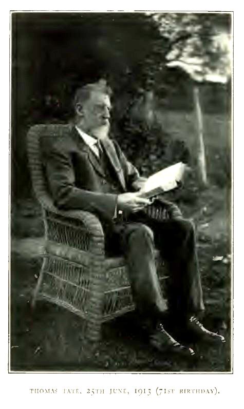
Thomas Tate, 25 June, 1913 (71st
Birthday)
{Page 392}
Leave Stewart River. Camp 33. Balclutha Creek. Horse Poisoned. Camp 34. Fine Lagoons. Camp 35. Annie River. Friendly Natives. Saltwater Creek. Camp 36. On Kennedy's Tracks. Annie River. Camp 37. More Friendly Natives. Sun-observations for Latitude. Camp 38. Confusion of Normanby and Kennedy Rivers due to Anastomosis of Mouths on Coastal Plain. The Kennedy River named in Honour of Kennedy, but not seen by him. Alligators. Camp 39. The "Easy-going Correction" applied to Distances. Jack River. Camp 40. The Unquestionable Normanby River. Camp 41. Boy induced to visit Camp. Expedition suspected of Kidnapping, and Consequent Collision with Natives. Fossils in Battle Camp Range. Its Age. Upper Cretaceous or Permo-Carboniferous? Camp 42. Last of the Normanby River. Camp 43. Watershed of Peninsula Crossed. Miss Endeavour River and drop into Oaky Creek. Cunningham's Range. Camp 44. Oaky Creek falls into Annan River, which is mistaken for Endeavour River. Annan River. Camps 45 and 46. Walker Bay At Mouth Of Annan River. Camp 47. Hann's Impressions Of Walker Bay, which he mistakes for the Endeavour Estuary. Cannot agree with Captain Cook. Success of the Palmer Goldfield. Opening of Endeavour Harbour and Foundation of Cooktown.
HAVING attained his object in reaching the 14th parallel of south latitude, Hann turned southward on 6th September, 1872, following at first the south-western shore of Princess Charlotte Bay as closely as the mangroves and swamps permitted.
Camp 33 is shown by the sketch-map to be about two-thirds of the distance (6 miles) separating the Stewart River from Balclutha Creek, i.e., 4 miles south of the mouth of the Stewart. (See MAP E.) The Diary makes it 11 miles.
On 7th September, a creek "with abundance of water" was crossed within a short distance of Camp 33. This creek is named the Balclutha in the sketch-map. A horse was left behind here. The animal appeared to have been poisoned and a drink of water at the creek finished him. Camp 34 was on "a creek with a little muddy water in it." The distance travelled was about 20 miles, and the camp would be about 14° 24' of south latitude.
On 8th September, a distance of 10 miles was travelled, in a south-easterly direction. Several lagoons and creeks were passed. One fine lagoon, 6 miles from Camp 34, was selected as a camping place, but the horses would not look at the old grass, and the new "burnt feed" was so short that it meant rambling and semi starvation, and the men, very unwillingly, repacked and went on for 4 miles to a moist teatree flat where there was good feed and where water could be obtained by digging. Camp 35 must have been about 2 miles north of the Annie River. It is worthy of note that two sheep had come with the party as far as this camp, where they were lost, but were recovered through the "unerring eyesight" of the black boy Jerry.
On 9th September, a stage of 10 miles south-east and 2 east was made through inundable country. At a lagoon, 2 miles from Camp 35, probably on the Annie River, some natives were met, and fish-hooks were amicably exchanged for a net and string of native manufacture. Camp 36 was on "a creek with large waterholes"—Saltwater Creek, which rises near the Musgrave Station on the Cape York Telegraph Line.
From the Stewart River to Saltwater Creek, Hann's track coincided with, or at least was parallel and close to, Kennedy's track, Kennedy having crossed the Annie River on his northward journey on 9th October, 1848.
On 10th September, a march of 2 miles to the east brought the party to the bank of a large river fringed with clumps of fan palms of immense size and beauty. Camp 37 was pitched here, as the Leader was convinced that he was now on the river seen by Kennedy on 9th October, 1848. Kennedy's River was described by Carron as "deep, and about 100 yards wide, the water salt, and the banks high." And there is every reason to believe that it was the Annie River, as, according to Carron, it enters Princess Charlotte Bay in 14° 30' S. lat.
The expedition halted for a day at Camp 37, while Hann and Jerry explored the lower reaches of the river.
On 12th September, the party followed the river up to the southeast for 14 miles as Hann supposed, but actually for about 10. Camp 38 was on the left bank of the river. A day's halt was made here while Hann, Taylor and Jerry rode down the river, where they met with "several mobs of natives, most of them friendly", to whom presents of fish-hooks were made. In their absence Warner made a last attempt to "take the sun", but as the angle could not be read on the sextant, it was concluded that in future distances would have to be computed by dead reckoning.
Hann was sorely puzzled by this river. At first he had no doubt that it was "Kennedy's River", and "Kennedy's river" had become defined in his mind as the "Kennedy River" indicated in Carron's sketch-map. The river seen by Kennedy on 9th October, 1848, was, however, the Annie River. The reach of the river on which Hann was now camped, between his Camps 37 and 38, is now named on the 4-mile map the "North Kennedy River", and the same name is given to Therrimburi Creek, a water-course coming from the south and passing Koolburra Station; and I have elsewhere suggested the propriety of avoiding the confusion resulting from the multiplication of "Kennedy" Rivers by calling the whole of this creek Therrimburi.
On his return to Camp 38, Hann had come to the correct conclusion that the river at that camp was "water never seen by Kennedy, it being many miles to the east of his track." He adds: "As this is a large and remarkable river, and one discovered by this expedition, I have named it the Normanby, after Lord Normanby, the present Governor of Queensland."
Local usage has fixed beyond recall the name of "Kennedy" to the river up which the coach road from the head of the railway, at the Laura, goes to Maytown, on the Palmer Goldfield. The name must stand, but the river, it must be understood, is named in honour of Kennedy, although Kennedy never saw it. The idea that Kennedy came down the river which now bears his name is sufficiently refuted by Carron's narrative.
Local usage has also attached the name "Normanby" to the river crossed by the Cooktown-laura Railway between Alderbury and Battle Camp stations.
Hann's perplexities arose from the fact that the phenomena of anastomosing river mouths which puzzled the Brothers Jardine on the western littoral of the Peninsula were repeated, on a smaller scale, in the coastal plain south of Princess Charlotte Bay. Following the rivers from east to west, the Normanby is first joined by the Kennedy River. The conjoined river, on approaching the Bay, splits into at least three mouths, the eastmost bearing the name of the Normanby on the 4-mile map, a second named the Bizant, and the westmost named the North Kennedy. The Normanby, above the branching-off of the Bizant, leaks into the so-called North Kennedy.
On 14th September, the expedition followed the river up for 3 miles to the south-east, when it branched (the western branch being Therrimburi Creek), and he followed the eastern branch. On the south-east reach of this eastern branch Hann noted "numerous alligators' heads all stuck on a sapling tree, but whether as trophies of the chase or some superstition entertained by the natives with respect to these animals is unknown. All the other parts of the body appeared to have been well cleaned, showing no compunctions as far as a feast was concerned supposing the brutes to have been eaten." Incredible as it may have appeared to Hann, alligator steaks are something of a dainty, as the aboriginals must have been well aware.
The "eastern branch" which Hann followed was one of the channels by which the Normanby proper leaks into Therrimburi Creek, the conjoined water-course forming the mouth of the Normanby which at present (rather unhappily) bears the name of the "North Kennedy River". After following this channel for 7 miles, Camp 39 was pitched on a swamp near the point where the channel leaves the Normanby proper.
The position of Camp 41 is fixed by the sketch-map, and subsequent conversations with Hann and correspondence with Taylor have left me in no doubt that it was on the Normanby River due north of the "Welcome" Station on the Cooktown-Laura Railway. According to the 4-mile map, the distance between Camps 39 and 41 is 55 miles, and yet Hann's diary relates that this distance was covered in two stages, of 21 and 8½ miles respectively, leaving 25½ miles unaccounted for. There may have been some carelessness in making, or error in transcribing the Leader's notes, or, as he had very "easy going", he travelled faster than he knew and did not apply the necessary correction. In any case, a journey of 55 miles in two days with a team of horses that had been so long on the road and living on grass only, was a feat which speaks eloquently of the care with which the members of the expedition had "nursed" their riding and baggage animals.
Taking into consideration the fact that Hann's diary and map give the distance between Camps 39 and 41 as 29½ miles, whereas the modern 4-mile map makes it 55 as the crow flies, the position of Camp 40 is very much in doubt. It was probably either on Embley's Jack River or his Brown Creek. I am inclined to decide in favour of the former, which, at all events, Hann must have crossed, whether he camped on it or not. The total distance (Camp 39 to Camp 41) covered by Hann, which he divides into two stages of 21 and 8½ miles, must be proportionately stretched to include the 25½ miles unaccounted for by him. If I am right, the second day's journey (16th September) would be 23 miles to Camp 41 on the Normanby. The river here has now been known for many years, both popularly and officially, as the Normanby, and has a valley of its own, with no confusion of branches anastomosing with other rivers or of mouths each claiming to be the "main stream". At Camp 41 it was running from east to west.
In the course of the day, Hann observed some women and children on a lagoon fishing with a net. natives were also seen by Tate and Jerry, who were travelling in the rear of the procession, and Tate brought a little boy into the camp, mounted on the front of the saddle, the boy apparently happy in his novel experience. "In the afternoon, Jerry and the little boy strolled out together in search of wild honey, but returned in a short time followed by a mob of excited natives. The white men met the natives, and, after some 'chattering,' neither party understanding the language of the other, the natives retired, taking the little boy with them, apparently amicable and satisfied that he had not been kidnapped or had been an unwilling visitor, but they displayed 'evident signs of triumph.'"
Next morning (17th September), while Stewart and Jerry were collecting the horses, they were attacked by two distinct parties of natives, who threw spears. Stewart drove the horses towards the camp, from which the other white men sallied to his rescue, firing two shots at long distance. "The effect was instantaneous; the quick advance was immediately turned into as quick a retreat."
Having packed up after this incident, the party travelled east-south-east for 7½ miles, and camped (Camp 42) at the foot of what is now known as the Battle Camp Range. The name does not, as might be supposed, commemorate the skirmish of this morning, but a stand made by the natives some two years later against a party of native police and officials, with prospectors, on the way to the Palmer Goldfield.
From this range, Taylor collected fossils, two of them identified by the late Mr. Robert Etheridge, F.R.S., of the British Museum, as belonging to the genera Ostrea and Hinnites. As both these genera have a wide vertical range in time, and the specimens do not seem to have been specifically determinable, the mere identification of the genera does not help in assigning a firm geological horizon to the strata of the range, which Taylor claimed as "Carboniferous", and to a wide-spread formation of the same character, whatever its age may be. The point is of importance, and I have myself searched the Battle Camp Range on four different occasions without finding the fossiliferous bed. [1] I have always been inclined to regard the Battle Camp Range, and other tablelands which must at one time have been continuous with it, as part and parcel of Daintree's "Desert Sandstone" (Upper Cretaceous). In the comparatively low-lying area south of the range which is now traversed by the Cooktown-Laura Railway, there are sandstones and shales with thin coal seams, but they have yielded only indistinct plant remains of no value for palæontological purposes. These strata are characterised by a great paucity of fossils, which is in marked contrast to the undoubted Permo-Carboniferous strata at Deep Creek, Oaky Creek and the Little Kennedy River. [2] At the Little Kennedy, near Palmerville (see Sheet 18C, 4-mile Map), the Permo-Carboniferous formation, which is highly fossiliferous, coal-bearing and much disturbed, is succeeded unconformably by a horizontal cake of sandstone which I believe to be continuous with the Battle Camp Range and other fragmentary ranges of the district which I have classed with the Desert Sandstone. [3] The question can only be settled on the production of sufficient palæontological evidence, read in the light of careful stratigraphical work.
[1) See Geology and Palæontology of Queensland and New Guinea, by Robert L. Jack and R. Etheridge, Junior. Brisbane and London, 1892, p. 531.]
[2) Op. cit., p. 533.]
[3) Op. cit., p. 175.]
On 18th September, the party travelled 10½ miles south-eastward up the left bank of the Normanby. Crossing the river about 2 miles south of where the railway now crosses, Camp 43 was pitched on the right bank. Here they were little more than a mile from the head of Cook's Endeavour River (near Alderbury Railway Station), the divide between the Princess Charlotte Bay waters (Normanby River) and those of the Pacific (Endeavour River and Oaky Creek) being here very close to the right bank of the Endeavour.
On 19th September, after crossing the divide, on a south-easterly course, a steep descent led to Oaky Creek, which was followed eastward to a point 14 miles from Camp 43. Camp 44 was on the bank of the creek south of Cunningham's Range, and about 4 miles west of the modern township of Hamilton. The prevalence of Casuarina trees led Hann to add one more to the already intolerably long list of Oaky Creeks. He and Taylor visited the range, which is composed of horizontal sandstone.
Eight and a half miles further down Oaky Creek to the east, brought the party on the following day (20th September} to Camp 45 between the modern Hamilton Township and the junction of Oaky Creek with the Annan River, a distance of about 8 miles.
In 3 miles further eastward down Oaky Creek, the party found themselves, early on 21st September, on the left bank of the Annan River, into which Oaky Creek falls, and which here runs northward, although immediately after its junction with Oaky Creek it turns and flows eastward into the sea. Hann was firmly convinced that this river (the Annan "was) no other than the Endeavour, of which so much has been said and heard from time to time." To a traveller approaching the sea from the landward side the Mistake was not an unnatural one, although it would have been impossible for Hann to have made it if he could have taken his latitude accurately.
Near their mouths, the Endeavour and the Annan both run eastward to the sea and are only 5 miles apart. A high mountain, Mount Cook, lies between the mouths of the two rivers, and on the northern and north-western foothills of the mountain the modern town of Cooktown is picturesquely situated. Oaky Creek, above its confluence with the Annan, prolongs the valley of the latter to the west, parallel to the valley of the Endeavour, which is now followed by the railway from Cooktown to Laura. After leaving his Camp 43, had Hann borne a little to the left he would have dropped into the valley of the Endeavour instead of into that of Oaky Creek and the Annan.
Having forded the Annan about a mile up (south), Hann followed its windings down for about 10 miles, and fixed his Camp 46 on some fresh water adjacent to the mangroves, the river itself having by this time become salt.
On 22nd September, leaving the other members of the party in camp, Hann, Warner and Nation went 4 miles east till they were in sight of the sea (Walker Bay) at the mouth of the river. They observed four natives in a canoe. They selected a spot where the horses might camp on good water and grass "in the vicinity of a conspicuous hill on the south side of the river" (Walker Hill). Here they came on the remains of a deserted fishing establishment belonging to Towns & Co. Camp 47 was settled here next day (23rd September).
Firmly convinced that he was now on the ground where Captain Cook spent eleven weeks in 1770, Hann was disappointed and somewhat soured by his failure to follow Cook's description. Naturally he "did not discover", as he says, "the spot used by Captain Cook as a careening ground for his ship." He continues (see Diary):—
"This is an exceedingly pretty place, and it is much to be regretted that the Endeavour does not hold out prospects for settlement, but there is nothing on it but its beauty, that we have seen, that would induce anyone to come to it. The soil is poor, therefore what else would induce people to come when so many other places within easy communication with civilised parts are still open? However, I shall follow the river up as far as I can, and look to its mineral capabilities."
In the Report he remarks:—
"The bay and its environs are exceedingly pretty; for a settlement it would be a charming place, being picturesque and compact, but when this has been said, all has been said. From time to time, the Endeavour has cropped up as being a wonderful place for many things; amongst others some fabulous ideas were afloat about its richness in gold. It has fallen to my lot to dispel these by pronouncing it, in mining phraseology, a "duffer": it has no gold, no good land, nor anything beyond scenery and its pretty situation to recommend it."
Fortunately, the Admiralty charts already showed that Cook's Haven was no chimera, and shipmasters had no difficulty in finding it as soon as a convenient port for the Palmer Goldfield was called for. Hann's report on the conclusion of his journey was followed by the start of a prospecting party who proved the existence of payable gold ON the Palmer, and the establishment of the port and the foundation of Cooktown were accomplished in the year 1873. In 1877, when I first saw it, the town was a busy centre of distribution and contained more "first-class hotels" than I dare to say.
{Page 399}
Up the Annan River. Trevethan Creek. Camp 48. Scrubby and Mungumby Creeks. Annan River. Hann's Mistake as to Position of Mount Cook. Horses Poisoned. Annan River and the Hills to the East, Stanniferous. Wallaby and Baird Creeks. Hostile Demonstration by Natives. Camps 50 and 51. Annan River Headed. Dense Jungle extends to Mouth of Blomfield River. Painful Travelling. Camps 52-54. Weary Bay. Mouth of Blomfield River. Sugar Land. Mount Peter Botte. Try to run Blomfield Valley up. Forced Westward among Jungle-clad Hills. Increasing Difficulty of Travelling. Daintree Waters. West Normanby Waters. Camps 55-59. Watershed or Peninsula. Camp 60. Adeline Creek. Head of Daintree River. Camp 61. Large Snake. Friendly Natives decline to guide Party To The Sea. There is no Land Way. They Themselves come in Canoes up the Daintree. Camps 62-64. Prospect from a Hill. Impenetrable Scrub. Convinced of Impossibility of reaching the Sea. Resolve to go West. Friendly Natives pilfering. On Track of the subsequently discovered Climbing Kangaroo. Tin, Wolfram, Molybdenite and Bismuth in "Main Range".
THE journey up the valley of the Annan (the supposed Endeavour) River commenced on 25th September, 1872, after the horses had enjoyed a couple of days on good grass at the southern end of Walker Bay. First retracing their steps to Camp 46, the party struck WSW. and crossed to the left bank of the Annan below the mouth of Trevethan Creek. (See MAP G.)
Camp 48 was on the left or western bank of the Annan about 2 miles south of the creek. The river was hemmed in by ranges on both sides and travelling was difficult. The day's journey amounted to about 15 miles.
The difficulties of travelling increased next day (26th September). Thirteen miles (to the south) were gained by following the Annan River where it was possible and climbing the hills, sometimes by dangerous "sidelings", where the valley was too rough.
Scrubby Creek was crossed, falling into the left bank, and Mungumby Creek, falling into the right. A casual allusion, in the Diary, to "a spur from Mount Cook" coming down to the right bank shows that Hann took the mountain mass east of the Annan for Mount Cook, instead of the isolated hill between the mouths of the Annan and Endeavour. Some poisonous herbage had been eaten by Hann's best mount, which died at the camp. Two other horses appear also to have partaken of the poison, and were not considered out of danger for at least three days and were not fit for work for some weeks.
It may be mentioned that some years later, the Annan Valley and the mountain mass lying between it and the sea, including Mount Thomas and Mount Amos, produced a considerable quantity of tin oxide, of which the greater part was in the form of stream tin. A dredging scheme has lately been set on foot with the object of recovering stream tin from the lower reaches of the river.
Camp 49, of 26th September, appears to have been on high ground between Wallaby Creek and Baird's Creek, tributaries of the Annan's right bank.
On 27th September, the day opened with something of the nature of a war-dance by natives on a hill, but the "demonstration" was not followed up by any hostile act. Much time was spent, and lost, in following old tracks of natives, in the hope that these would lead to a way out of the "steep mountains and dense scrub". A progress of 5 miles to the south was the gross result of a day of severe toil. Camp 50 was on the left bank of the Annan, about 15° 49' S. latitude.
On 28th September, the party climbed up the valley of the Annan, partly in the rough bed of the river and partly over steep slopes covered with dense scrub, and appears to have reached a point very near the head of the river in about 3 miles to the south-east. Camp 51.
From the head of the Annan (which, it must be remembered, Hann called the Endeavour) to the mouth of the Blomfield River, in Weary Bay, the path had literally to be hewn foot by foot through a dense jungle which covered steep and dangerous slopes. A general south-eastward course was kept, but many deviations were forced on the travellers by the nature of the country. Camps 52, 53 and 54, of 29th September and 1st and 2nd October, appear to have represented gains of 3, 2, and 2 miles respectively. Frightful risks were taken. In one place a horse fell on a "knife-edge ridge", and must have been killed if the ground had been clear; but the trees were close enough together to save him from death. Another horse rolled over no less than four times before he could regain his footing.
The mouth of the Blomfield River was safely reached on 2nd October, but in this region the shore of the Pacific affords no footing for travellers. Some 12 miles south of Weary Bay, Mount Peter Botte rises to the height of 3,311 feet, and slopes steeply down to Captain Cook's "Cape Tribulation".
The Blomfield River, which is barely 30 miles long, reaches the Pacific on a north-easterly course. Hann's idea was, without crossing this river, to follow it up in the hope that it would take him some way on his course, and lead him into better country. The word "country" is used here as Hann regarded it from his point of view, that is, country fit to travel over. As "country", from an agricultural point of view, the Blomfield is good enough. Its cleared scrub land, in the present day grows sugar-cane and is a valuable asset of the State.
Camp 55 was pitched on the left bank of the Blomfield on 3rd October.
The river, indeed, followed a course which would have taken the expedition for some distance south, had it been possible to follow it. The banks, however, were so steep and so scrubby that it became necessary to leave it at Camp 55, and take to the hills.
It would be unprofitable, even if it were possible, to follow minutely the daily record of Hann's wanderings in the scrub. His one idea was to get away south, and to this end he and his companions toiled, and struggled day after day. Paths were laboriously hewn through the jungle and the horses were led on; and as often as not it was labour lost, as some insurmountable obstacle would force them back on their tracks, or round in a direction that was not at all to their liking Until he tackled the Annan (which he called the Endeavour), Hann, looking back, forgot all his previous troubles, and declared that "the expedition had been a pleasure trip." He added that since crossing the Endeavour (Annan) "there have been nothing but troubles and difficulties, with still more ahead, and how they will end remains to be proved." Above all, there was no time for anything like careful charting. Already on the second day from Camp 55 (5th October) Hann had left the waters of the Blomfield behind and was on those of the Daintree River, without knowing it. The course of the Daintree was at that time unknown to him and all the world, and as for landmarks, he might as well have been travelling through a dark tunnel. The Daintree River was discovered and named after Richard Daintree, then Agent-General for Queensland, formerly Government Geologist, by G. Elphinstone Dalrymple in 1873. [1] On the fourth day (7th October) his Camp 59 was on the "West Normanby", one of the heads of the river which he had himself named, but he never suspected the fact. By this time he had gained, from Camp 55, at most 4 miles of the desired southing and something like 23 miles of westing. Probably the actual distance travelled was not less than 40 miles.
[1) Queensland North Coast Expedition of 1873, par. 436.]
The party had hardly gone a mile west of Camp 59, on 8th October, when they saw in front of them the "main range", the watershed between the Gulf and the Pacific. To their eyes
it appeared "a perfect barrier to further progress". It may be remarked that at a later date the perseverance of prospectors was rewarded by the discovery of at least two passes through this part of the range, by which tracks were made to give access to the gold-diggings of the Upper Palmer; but Hann did not wait to seek for passes. After consultation with the other members of his party, he decided to make another attempt to reach the coast. The course was altered to south and south-east, and after a day's march of 13 miles, "equal to 30 on level ground", Camp 60 was pitched on "a creek among the ridges."
On 9th October, only 2 miles were made, to ESE., and the party camped, as Hann supposed, on the Blomfield River, but probably on Adeline Creek, a tributary of the Daintree. Camp 61.
On 10th October, the march continued to the south-south-east for 4 miles to Camp 62. The head of the Daintree must have been crossed. A snake 16 feet long was shot, and Jerry enjoyed a full meal after his own heart, in which the white members of the party gladly shared.
The expedition moved forward about 4 miles to the south-east on 11th October, and Camp 63 was pitched on a scrubby creek, with plenty of water, which, however, could not be reached by the thirsty horses because of the steepness of the banks. Hann and Jerry had gone ahead of the party when they met a party of very friendly natives, from whom it was hoped information could be obtained regarding a way to the sea. The natives accompanied Hann and Jerry on their return to Camp 63. Here the Leader found, to his annoyance, that Taylor, who had been put in charge, refused to accept such a responsibility for the future, as Tate had "entered into a warm altercation with him."
After the midday meal at the camp, Hann started out to explore, accompanied by Nation and Jerry and two of the friendly natives to act as guides. In 3 miles they reached the summit of a ridge to the south-east, and wished to proceed further in the same direction. The "guides" disapproved, pointed in another direction, and finally slipped away. It soon became apparent that the guides had been in the right. "At our feet", says Hann, "lay miles of thick and impenetrable scrub, covering ridges and gullies alike; to have ventured into it, with or without horses, would have been sheer madness, as the sea lay miles away not even in sight. The prospect was worse than anything seen by us hitherto. Cape Tribulation and the country for miles around its base was a sea of scrub, which extended as far as our vision in a southerly direction. We turned away from the prospect with a dismal sensation of disappointment, as we had hopes that this was our way out—whereas, it proved a gate shutting us in more completely than ever. But still there was one other hope, and that was the road indicated by the natives, so we buoyed ourselves up for another trial and returned to camp."
On 12th October, Hann started early, accompanied by Tate, Stewart and Jerry, with a native "guide." In 3 miles to the south-east a site was selected for Camp 64. Stewart was sent back to bring on the expedition to this point, and the others penetrated about 6 miles further to the south-east, and got on a high hill.
"Our doom is sealed", says Hann. "All further progress south is debarred us, and the retreat to the westward has become imperative; it is now a case of personal safety . . . I saw at once how completely I was frustrated in my desire to reach the coast, which, if I had reached, would have wrecked the expedition. From this eminence I had a view of the whole country beneath me. Towards the sea stretched miles of broken country densely covered with scrub of an impenetrable character. To the south, the Dividing Range towered to an immense height, forbidding approach, and also covered with scrub, which seemed to spread over the whole country. The range ended abruptly over the sea, and as far as I could discern, maintained the same character south, as far as visible. Here my last hope vanished, and I descended the hill with a feeling of disappointment exceeded by [exceeding] anything I had felt the previous day when I found my first road was shut against me. I have struggled hard, but to no purpose; all my endeavours have been frustrated by the completely impassable nature of the country for white men with horses."
The guide slunk off. Jerry had been told by an old man, one of the "friendly natives", that there was no possibility of reaching the sea; that they themselves reached it by canoes, which came up salt-water creeks to within a few miles of the camp. The navigable channel thus indicated must have been the Daintree River.
It was by the favour of God that Hann had the wisdom to admit his defeat. Had he been endowed with the unbending pertinacity, or obstinacy, of Kennedy, he would have gone on at all risks, to perish with his whole party. His dilemma was now a sharp-horned one indeed. The formidable character of the westward route had already decided him to try the coast, which was found to be impossible, and the difficulties of the westward route had by this time been seriously aggravated. On a deliberate review of the situation, these difficulties resolved themselves into the physical weakness of some members of the party, worn out with fatigue and faced with inevitable scarcity of food, and the leg-weary condition of the horses and the chances of drought and want of grass. Nevertheless, the westward retreat was the lesser of two evils, and no other course was now open.
On Hann's return to Camp 64, it was reported to him that the "friendly natives" had given annoyance by pilfering.
While traversing these scrubs, Jerry described a climbing kangaroo which he had seen in the Cardwell district, and showed Hann and Tate trees bearing the marks of the ascent of some such animal. Although they did not see the animal itself, which was then unknown to science, its subsequent discovery places beyond doubt the accuracy of Jerry's information and description.
It may be remarked that the "Main Range" which Hann saw towering "to an immense height" contains mines of tin and of the rarer minerals wolfram, molybdenite and bismuth.
{Page 405}
Attempt to reach Coast Abandoned. Leave Camp 64. Normanby Waters. Flat Creek. Camp 65. Threatening Natives. West Normanby River. Camps 66 And 67. River named the Hearn, now the Laura. Camp 68. Down the Laura. Camps 69 and 70. Hostile Natives repelled. Camp 71. Mosman River. Railway Terminus. Anastomosing Mouths of Normanby and Kennedy Rivers. Little Laura River. Camp 72. St. George's River and the Little Kennedy. Camps 73 And 74. Telegraph Line. Kennedy River. Kennedy Bend. Jack's Starting-point. The Little Kennedy. Fairlight. Camp 75. Watershed of Gulf and Pacific Rivers. Landmarks on Palmer recognised. Descent to Palmer. Camp 76. Mount Mulgrave. Camp 77. Mitchell River. Camp 78. Fine Soil. The Rolling Downs Formation again. On the Outward Track. Fish. Poisoned Horse. Walsh River. Camps 80 and 81. Walsh Telegraph Station. Up the Walsh. Camp 82. Muldoon Creek. Arbouin Copper Mine. Camp 83. Tate River. Tate Telegraph Station. Fischerton Mining Camp. Tin And Wolfram. Mount Mcdevitt. Granite. Pandanus Creek. Camps 84-86. Lynd River. Fossil Brook. Camp 87. Back among White Men. Springfield Lambing Station. Camp 88. Fossilbrook Station, The Original Starting Point. Mount Surprise (now Railway Station). Camp 89. Junction Creek Telegraph Station. Camp 90. The Journey's End. Summary. Geographical and Economic Gains.
BITTERLY chagrined over their failure to travel southward by the east coast, the party left Camp 64 on 14th October, 1872. Retracing their steps through the scrub, Camp 60 was passed on the third day (16th October) and the party struck west, shortly afterwards getting clear of the scrub and crossing a divide of "dry and hard-looking ridges", with a steep ascent. Camp 65 was on a creek, which Hann correctly surmised to be within the drainage area of the Normanby. It was, in fact, Flat Creek, which runs westward to join the " West Normanby."
Next morning (17th October), as Stewart and Jerry were hunting for a mare which had strayed, some natives yelled at them from a distance. This day's march was 10 miles down Flat Creek to the west and then northward down the West Normanby. Camp 66. Gins and children were surprised at the camp. Their camp contained several pieces of iron, one a rod used as a yam-stick. After dark, during Tate's watch, he heard blacks prowling about the camp. On his firing a shot they ran away howling, their flight being accompanied by the rattling of spears.
On 18th October, a progress of 10 miles to the north was made down the West Normanby. Camp 67 was probably not more than 6 miles west of Camp 59.
Leaving the West Normanby on 19th October, a basalt ridge was met with in 2 miles. The country from Oaky Creek to this point had been entirely of slate. The basalt continued for the remaining. 13 miles of the day's march to the north-west. From the point where the basalt was first seen, the party had been on the head-waters of the Laura. Hann named the branch which he followed, the Hearn [1] (the name of his wife's family) and camped (Camp 68). He believed it to be the Kennedy.
[1) Hann's name ought to stand, by undoubted right of priority, but the name of Laura, applied later, during the Palmer rush, has become too firmly fixed by usage, especially since the "Laura" became a railway terminus, to be altered now.]
The river (the Laura) still running to the north-west, with the dividing range—which he judged to be impassable—a few miles to the left, Hann followed it next day (20th October) for 9 miles to Camp 69. The country passed over was "stony and broken quartz ridges", with basalt on the right hand. Rain fell at night, for the first time during the journey.
On 21st October, Hann very unwillingly pursued his way down the Laura for 9 miles further to the north-west. Camp 70 was "close under a range of sandstone." The leader was most anxious to find a pass through the range and get away south, but was satisfied that "the horses could not climb these precipices." [2]
[2) In the beginning of 1875, the portion of the Hearn or Laura valley which had been followed down by Hann was already occupied as a fattening run for cattle. Expedition in Search of Gold and other Minerals in the Palmer Districts, by Mulligan and Palmer. Brisbane, by Authority, 1876, p. 1.]
Six miles from Camp 69, while Hann rode ahead of the party, he "came," as he relates, "upon a native, who at first ran away, but shortly returned with his friends, who began to shout and gesticulate and brandish their spears." He continues: "I rode away to join my party without paying any attention to them. In 1½ miles . . . the natives again made their appearance and began to yell at us, all being armed with spears. I now thought it necessary to disperse them, so four of us dismounted from our horses and advanced towards them. When one of our party went to within 80 yards of the mob, one native made himself more conspicuous than the rest by preparing his spears for an onslaught, but a ball fired in amongst them had the desired effect, for they all ran away without looking behind. This was all I wanted. I had no wish to have these fellows hovering about the neighbourhood, watching every chance to pilfer, or prowl about our camp at night."
Rain on the following day (22nd October) kept the party from travelling, and the day's "spell" was good for the horses.
On 23rd October, the valley of the Laura was followed down for 2½ miles. On the river turning to the west (with precipitous sandstone hills on both sides), the party turned south-west and, after travelling for 7 miles over sandstone and conglomerate, camped on a little water-hole. Camp 71.
On 24th October, the party marched 11 miles to WNW., when they came on a large river. This was the Mosman River, which falls into the Laura River, 8 miles to the north-east, at what is now the terminus of the Cooktown-laura Railway. Hann now came to the conclusion that all the waters he had followed or crossed between his 67th camp and the Mosman belonged to the Normanby, and not to the Kennedy, to which he had been assigning them. The mouths of the Normanby and Kennedy, as already pointed out, anastomose; but their upper valleys are distinct, and Hann had arrived at the truth in his latest surmise.
Having crossed the Mosman, a march of 8 miles brought the party to "a large running creek, with fine feed for the horses." This was the Little Laura, which falls into the Laura 10 miles north of the present railway terminus. Camp 72, which was in sandstone country, was probably on the left bank.
On 25th October, the course for the first 6 miles was a little to the south of west, when a sandstone cliff forced the party 2 miles to the north. A narrow gap in the cliff was at length found, and by this the horses made the ascent with great difficulty and danger. On the top of the sandstone, the head of a creek was found and followed to the west for 6 miles to Camp 73. This creek was the head of the St. George River, which joins the Kennedy River, de facto, above the "Kennedy Bend", the terminus of my first, and starting-place of my second, expedition in 1879.
On 26th October, the St. George's River was followed westward for 7½ miles to Camp 74, at its junction with the Little Kennedy River, where at the present day the road and telegraph line run southward to Palmerville.
To solve their doubts as to whether or not they had now crossed the divide into western waters, Hann and Taylor ascended a hill near the camp, and the latter recognised, on looking southward, some remembered features of the Palmer. They concluded therefore that they were still on eastern waters, and that Camp 74 was on the Kennedy. It was, in fact, on an eastern head of the river named in honour of Kennedy. A tributary valley was seen coming from the south towards the camp.
Up the creek which forms the tributary valley, and to which the name of the Little Kennedy River is now applied, Hann and his companions travelled 5 miles southward to Camp 75 on 27th October. The camp was on the site of the present U Cattle Station. The Little Kennedy has a longer course than the St. George, although the conjoined stream bears the latter name until it falls into the Kennedy proper.
On 28th October, 11 miles to the south, up the Little Kennedy, brought the party to the summit of the Divide, from which Hann could see Mount Mulgrave and other familiar landmarks. A pass so narrow that the horses had to travel in single file led down into the valley of the Palmer. The river was reached in a mile and a half from the summit, and Camp 76 was pitched on its bank, opposite the mouth of Glenroy Creek, between the camp of 10th and 11th August and that of 12th August.
Hann was now on well-known ground. He steered south on 30th October for the east side of Mount Mulgrave, at the south end of which he fixed his Camp 77. He estimates the distance travelled at 17 miles, whereas it cannot have been less than 22, which shows the necessity for the "easy-going" correction.
On 31st October, 12 miles brought the party to the Mitchell River, on the right bank of which Camp 78 was pitched, opposite the old Camp 16.
On 1st November, the party travelled 21 miles south by west to Elizabeth Creek, on which Camp 79 was made. The day's journey was on the track now followed by the telegraph line from the Walsh to the Palmer. The first 3 miles were basalt, to which succeeded 3 miles of sandy flat, and the remainder of the journey was on a limestone formation. This bore, says Hann, "some of the finest soil conceivable, the same as noted by me on the outward trip."
An old horse, which had been failing ever since, with some others, it had been poisoned on the Annan on 26th September, could be driven no further, and was left behind at this camp. Great hauls of fish were made in the Palmer and Mitchell.
The camp was moved 3 miles south on 2nd November to an ideal spot for grass and water for the horses. Camp 80 was on the site of the modern Walsh Telegraph Station, and about 2 miles north of Camp 12 of Hann's outward journey.
The right bank of the Walsh was followed up for about 12 miles on 3rd November, and Camp 81 was between the former camps Nos. 11 and 12. A further search was made for fossils, as the camp was where a collection had been made on the outward trip, but nothing new was found, and those which had been hidden in a cache had been spoiled by exposure to water.
Still following the right bank of the Walsh for 9 miles, Camp 82 was fixed next day (4th November) about 3 miles south-east of Camp 10, and at or near the present crossing of the telegraph line.
Having crossed the Walsh about a mile south-east of the camp of 5th November, the travellers immediately got among scrubby sandstone hills, which they cleared in 6 miles. They apparently travelled southward, east of Muldoon Creek and west of the Arbouin Copper Mines.
As soon as they got clear of the sandstone hills, the party followed Muldoon Creek to its head, and 22½ miles from Camp 82, camped at sunset on the divide between the Walsh and the Tate. (See MAP K.) At Camp 83 there was no water. The telegraph line and road from the Walsh to the Tate now follow Hann's track of this day.
On 6th November, Hann continued his journey to the southeast and struck the Tate River in 8 miles. He then followed the right bank, on the same course, for 2 miles, and, at what is now the Tate River Telegraph Station, crossed to the left bank and camped on "splendid feed for the horses". Camp 84.
The windings of a tributary of the Tate were followed up for 11 miles to the south-east on 7th November. The actual distance gained to the south-east appears to have been about 6 miles, but something must be allowed for the windings and also for the "fatigue" correction. There was "fine grass for the horses" at Camp 85. Hann was of opinion that the country traversed was "most promising-looking for gold", in fact, "the best-looking country seen by us yet." So far as I am aware, no gold has yet been discovered on Hann's actual route (Camp 84-85), but it is interesting to note that the Fischerton mining camp, the centre of the Tate River Mineral Field, is only a few miles to the east. Lode tin and wolfram are worked in this neighbourhood.
Five miles south-east of Camp 85, a hill, which was named Mount McDevitt, was left on the right on 8th November. The course was then altered to south by east, the first 3 miles being over granite ridges. Three miles more over flat sandy country brought the party to "a shallow creek", probably Pandanus Creek, where Camp 86 was pitched. Heavy rain fell during the night.
On 9th November, the right bank of the Lynd River was reached in 6 miles. Two miles further east, the river was crossed, and the outward track was followed for 6 miles to the south-east up the left bank of Fossil Brook. Camp 87 was about 3 miles southeast of Camp 2.
The modern telegraph line practically follows Hann's route from Camp 78 to Camp 87.
On 10th November, the left bank of Fossil Brook was followed for 12 miles to SSE., and Springfield, "a lambing station of Firth's", was reached, and for the first time for four and a half months the travellers greeted white men. This station, which may be called Camp 88, is only 5 miles down the brook from Fossilbrook Station, the starting-point of 26th June.
Mr. Firth's head station, Mount Surprise, was reached on 11th November. Camp 89. This is now a station on the Etheridge Railway, which leaves the railway from Cairns to Chillagoe at Almaden.
On 12th November, 1872, Hann reached the Junction Creek Telegraph Station and entered into communication with the Hon. W. H. Walsh, Minister for Public Works and Goldfields. Camp 90. This telegraph station has now been removed to Mount Surprise Railway Station.
Hann's contribution to geographical knowledge of the Cape York Peninsula was of equal importance to that of any of his predecessors.
Commencing on the river named the Lynd by Leichhardt he followed it down to the north-west for 30 miles. Sixteen miles to the north he found a new river which he named the Tate, a tributary of the Lynd. Twenty-eight miles to the north he found and named the Walsh River, a tributary of the Mitchell. He traced the Walsh for 45 miles till it fell into the Mitchell, and thence followed the Mitchell itself westward for 30 miles to the junction of the Lynd, joining lines at this point with Leichhardt. He also traced the Mitchell up from the junction of the Walsh for 60 miles to the east, almost to its confluence with the Hodgkinson River. The Palmer River was next found about 30 miles north-west of the Mitchell. This important tributary of the Mitchell must have been crossed by Kennedy, who, however, left no record. Struck by its auriferous capabilities, Hann explored the Palmer for 50 miles to the east. From the Palmer (near Lukinville) he then travelled north-westward for 80 miles, to a new Gulf river which he named the Coleman, the greater part of the journey from the Palmer to the Coleman having been on or near the watershed of the peninsula. He traced the Coleman down for a few miles till it began to run westward and northward for 20 miles to its head.
Pursuing his northward course, almost on the watershed of the Peninsula, Hann in 40 miles struck a river which he named the Stewart and identified as one crossed by Kennedy. This river he followed down to the east for 30 miles till it discharged into Princess Charlotte Bay.
Having reached the latitude of 14 degrees south and thus completed the task which he had set before himself, Hann now turned homeward. South of Princess Charlotte Bay he was inevitably mazed by the anastomosing of the mouths of the yet-uncharted Kennedy, Morehead and Normanby Rivers. From one of these mouths, which he named the Normanby, he then marched south-east for 50 miles, striking, near the Battle Camp Range, the river now known as the Normanby which here runs in a valley of its own. After following the valley up for 22 miles, he turned his back on its right bank and found himself in a few miles on a watershed in which the Endeavour River and a branch of Oaky Creek rise close together, to flow eastward to the Pacific over beds only a few miles apart. He missed the Endeavour by only a mile or two, and ran down Oaky Creek for 20 miles to the east, when it fell into a river which came from the south and then turned east. His next procedure was to follow this river for about 8 miles to its mouth in Walker Bay, firmly convinced that it was the Endeavour, although he was unable to reconcile his surroundings with Captain Cook's description. The river, in fact, was distinct, its mouth being about 6 miles south of that of the Endeavour, and is now known as the Annan.
Having observed that the Annan came from the south, and his objective lying in that direction, Hann gladly embraced the opportunity of following the river (the supposed Endeavour) to its head. He succeeded, indeed, in this, but only in the face of great difficulties with tangled scrub, and dropped down on the mouth of the Blomfield River, in Weary Bay.
The course of the Blomfield again promised a means of getting away to the south, but the rugged and precipitous nature of its bed and valley soon forced the explorers to climb the hills above the left bank. The increasing density of the scrub and roughness of the scrub-masked country, however, made southerly progress impossible for a time. It was not till they had hewn their way 30 miles to the east, and were actually (although without knowing it) on the head-waters of the Normanby, and within a few miles of the head of the Palmer, that it became possible to get away to the south-east, in which direction they hoped to reach the east coast and find better travelling. With infinite toil some 40 miles were gained to the south-east, and as the travellers heard from natives of the only way to reach the sea being by canoes, they were probably not far from the lower reaches of the Daintree River. At this point, Hann bowed to the inevitable, and resolved to retrace his steps as far as he had come to the south-east. But for this wise and timely decision there is no doubt that the expedition would have perished in the jungle.
Having regained to the north-west the 40 miles lost in the attempt to reach the sea, Hann crossed the valley of the West Normanby and, continuing north-west, followed the Laura River (which he named the Hearn) down from its head for 40 miles, not very sure whether it was a "western water", or whether the apparently impenetrable range on his left was or was not the watershed of the Peninsula. The Laura, as is now known, is a tributary of the Normanby. When at last it became possible to go west-south-west, this course was followed for 40 miles, crossing the Mosman and the Little Laura, both tributaries of the Laura, and the "Little Kennedy" was met with. The valley of this river, coming from the south, offered a practicable course in the desired direction, and 15 miles of good travelling brought the party to a gap in the "Great Dividing Range", from which their eyes rested with satisfaction on familiar landmarks in the valley of the Palmer.
Having descended to and crossed the Palmer, Hann struck south, and reached the Mitchell in 35 miles. The Walsh was reached in 23 miles more to the south and followed (by the outward track) for 28 miles to south-south-east.
From the Walsh, a course was followed to south-south-east. The Tate was crossed at the site of the modern Tate Telegraph Station, some 13 miles above the outward track. The Lynd was met with, on the same course, in about 25 miles, and after crossing that river, the outward track was retraced to the south, up Fossil Brook to the starting-point of the expedition, which was reached on 10th November, 1872.
Hann's expedition, no doubt, owed a good deal to the fine weather which prevailed all the time it was in the field, but its successful issue was mainly due to the superior bushmanship of the Leader. It resulted in important economic developments, as it revealed the existence of an immense area of "good country", the pastoral occupation of which quickly followed the publication of the report. The indication of the presence of gold led the way to the opening of the Palmer Goldfield, with its far-reaching influence on the settlement of Northern Queensland. Finally, the discovery of the Tate and Walsh Rivers attracted a swarm of prospectors, who opened out rich mineral areas a few years later,
William Hann was drowned while bathing in the sea, at Townsville, on 5th April, 1889. Thomas Tate now (1920) resides at Peak Vale, near Clermont.
{Page 413}
Prospectors attracted to the Palmer by Hank's Report. Mulligan's Party leave Georgetown. Mount Surprise. Fossilbrook. Lynd River. The Rocky Tate. The Tate. Fischerton. Muldiva Creek. Walsh River. Camp 7. Site of Walsh Telegraph Station. Mount Mulgrave. Camp N. Fox Creek. Thompson's Range. Palmer River. Site of Palmerville. Camp 12. Hostility of Natives. Payable Gold. Prospecting and working Gold in Palmer River, North Palmer, Cradle Creek and Sandy Creek. Mounts Taylor and Daintree. Frome. First Discovery of Gold by Hann's Party. Warner's Gully. Site of Palmerville. Mulligan on Scenery. Leave Palmer for Etheridge. Mitchell, Walsh and Tate Rivers. Black Gin Creek. Arrival at Etheridge and reporting of Payable Gold on the Palmer. The First Rush from the Etheridge to the Palmer led by Mulligan.
HANN'S FIRST REPORT was made by telegraph from Junction Creek on 12th November, and a complete report, accompanied by a map and diary, was dispatched from his home at Maryvale on 20th December, 1872. These documents were published in Brisbane as Parliamentary Papers early in 1873.
The reported occurrence of gold over a wide area on the Palmer attracted the attention of miners, ever on the alert for the first hint of a new discovery, and the conviction grew that although mere "cattle men" like Hann and his companions might not consider the gold to be payable, skilled prospectors might follow it up to an El Dorado.
Several parties of prospectors set out without loss of time and were soon distributed over the new field. Among these were James Venture Mulligan, and his companions, viz., Albert Brandt, James Dowdell, David Robinson, Peter Abelson, Alexander Watson and Peter Brown, who left the Etheridge Goldfield on 5th June, 1873. [1]
[1) See Petition to Parliament. Queensland Votes and Proceedings, Session 1874. Vol. II, p. 755, and Heaton's Australian Men of the Time, 1879.]
A prospector is an explorer in every sense of the word (one is tempted to add "only more so"), but the circumstances surrounding his calling make for the concealment of the results of his labour up to a certain point. Let him "drop on a good patch of gold" and he naturally settles down to put the gold in his pocket with the least possible delay. It is true that by giving early notice of his discovery he may ultimately secure the standing reward, but he will do so at the cost of giving away his valuable secret, and will soon be surrounded by a crowd of diggers who will peg out claims and thus confine him to a limited area. If he can escape detection, he may make more in a week than the reward is worth. At any time, however, he may be tracked or accidentally detected in the act of amassing wealth, and in that case other gold seekers will deprive him of elbow-room, and may forestall him in applying for the reward. The successful prospector is thus always on the horns of a dilemma: to work on in secret and risk it, or to report payable gold.
After the discovery of payable gold on the Palmer had been publicly announced by Mulligan, other prospectors put forward their claims to the honour, in some instances giving accounts of their travels and doings. Such accounts, however, were for the most part contributed to the daily or weekly newspapers of the "seventies", in some cases to newspapers now defunct. Such publications rank as "fugitive literature", which no man may hope to marshal in evidence after the lapse of forty years. Mulligan's first explorations on the Palmer (1873-4) were no exception. His reports were contributed to the Queenslander newspaper, and would have shared the oblivion which has overtaken the reports of his contemporaries and rivals but for the circumstance that they were collected and reprinted in a Guide Book [1] in 1875. This guide book is very rare at the present day, but fortunately a copy has been preserved in the Mitchell Library, Sydney, and to this I am indebted for the text of the notes which follow.
[1) Guide to the Palmer River and Normanby Goldfields, North Queensland, showing the Different Roads to and from the Etheridge River, Cleveland Bay and Cooktown, with Map of the Palmer and Adjacent Goldfields and Journal of Explorations by James V. Mulligan, Discoverer of the Palmer River Goldfields, and to whose Party the Government reward was awarded. Brisbane, George Slater & Co.; Sydney, Gordon & Gotch; Melbourne, George Robertson, 1875.]
Georgetown, the centre of the Etheridge Goldfield, was, in 1873, connected with Firth's Station, Mount Surprise, by a road, about 85 miles in length. (See MAP K.) Mulligan covered this journey (eastward) in four days, arriving at Mount Surprise on 9th June, 1873. His route from Mount Surprise via Fossil Brook to its junction with the Lynd diverged but little from that of Hann. Nearly on the footprints of both Leichhardt and Hann, he followed the Lynd down to about the infall of Emu Creek.
On 19th June, he first broke new ground, leaving the Lynd and keeping a north-east course, and camped (Camp 3) on a large creek, a tributary of the Tate, no doubt what is now known as the Rocky Tate, and probably about the infall of Bullock Creek. He struck the Tate itself in about 8 miles to the north-east, and followed it down 5 miles westward to the junction of the Rocky Tate and camped 4 miles further down the river. Camp 5, 21st June. Prospecting near this camp, "colours" of gold were obtained. He had passed in the course of the day what was subsequently known as "Fischerton", the centre of the Tate River Mineral Field.
Leaving the Tate on 22nd June, Mulligan took a NNW. course, parallel to Hann's homeward track (Camps 82-84) and from 4 to 12 miles to the east of it. His Camp 6 was on Black Gin Creek, a tributary of the Tate. His Camp 7 (23rd June) was on the Walsh River, near the mouth of Muldiva Creek. (See MAP G.) Here he got "colours" of gold, and observed "thousands of blacks' tracks".
Down the Walsh to the infall of Elizabeth Creek, Mulligan's track coincided with Hann's outward track (Hann's Camps 10-12). Mulligan's Camp 9 was Hann's 80th camp on the return journey, and is now the site of the Walsh Telegraph Station.
Northward from the Walsh to Mount Mulgrave, Mulligan was on, or not far from, Hann's return track (Camps 78-79). His Camp 10 (26th June), on the Mitchell, was about 2 miles west of Hann's Camp 16, i.e., down the river. Here he got colours of gold and observed that the "darkies" were numerous. He passed Mount Mulgrave on its eastern side, and his Camp 11 (28th June) was on the head of Fox Creek, a tributary of the Palmer. Keeping the Thompson Range on his right, he dropped down on the Palmer on 29th June (Camp 12), about a mile above what was soon to become the township of Palmerville.
The aboriginal inhabitants of the Palmer valley had seen Kennedy's party in 1848, and in 1872 Hann's party had been there twice, having spent sixteen days on the first occasion. It was obvious to the natives that their country was becoming too much of a thoroughfare, and Mulligan's invasion could not be passed over without a protest. Accordingly the prospecting party had barely settled down when an attempt was made to burn them out by setting fire to the grass. The catastrophe was averted by the usual bush expedient of anticipating the fire by burning a ring of grass, taking care that the flames did not spread inward. In the meantime, the blacks climbed a hill from which they threw down great stones, shouted and brandished spears. That night a watch was set and the camp was never after left with less than two men while the other members of the party pursued their avocations.
Having moved camp twice for a short distance up the Palmer, the first week's prospecting was rewarded by six ounces of gold.
About a dozen blacks appeared on 6th July, but they were "civil", and the interview ended with the "exchange of cooeys" and mutual invitations to visit one another's camps, mutually declined owing to mutual distrust.
At a third camp up the river, payable gold was again met with, and the party worked with dishes, and having "made a few ounces", began to think of working on a bigger scale with a cradle and selecting a prospecting claim. On 13th July, they moved camp to the infall of Cradle Creek, so named "because we got timber here to make a cradle out of a Leichhardt tree, which we chopped down and chopped into boards with a tomahawk, having no other tool save a rasp and hammer."
Up to 16th July, the camp being still at the mouth of Cradle Creek, parties prospected the river up to the infall of the North Palmer, or "left-hand branch of the Palmer", as it is sometimes called, finding payable gold all the way, as well as in a tributary coming from the north, which they named Sandy Creek. The North Palmer was also found to be highly auriferous.
On 16th July, the party returned to their third camp on the Palmer, and while some settled down to work with the cradle, others rode down the river past Hann's Mount Taylor.
On 30th July, the camp was shifted a little higher up the river, and again (1 mile) on 1st August, to points where gold was plentiful. The majority of the party worked steadily on gold till 7th August, while the Leader and others extended their operations in various directions.
On 7th August they camped on the site of Palmerville, where they had resolved to make their headquarters beside what they were about to claim as a prospecting area.
An extract may here be given from the diary in illustration of Mulligan's singleness of purpose and his pre-Wordsworthian contempt for mere scenery, which bored him almost to the point of incoherence:—
"Due north," he says, "to the coast range close at hand, the range of sandstone capping is irregularly broken into by creeks and gorges, whilst, in a parallel line south, at the back of Thompson's Range, is horrid to look at, and really I think looks worse than it really is. On the whole, looking at the numerous bush fires and darkies' signal fires, which show so well this calm morning, the scene is terribly grand, and considered so far away in the wild bush, is a little shocking, though pleasing."
On 8th August, they got payable gold at Mount Taylor, down the river below Palmerville.
On 10th August, the camp was moved down the river to a point 5 miles below Mount Daintree, i.e., to what is now Frome, and was the site of Hann's Camp 20, near Warner's Gully, the scene of Warner's first discovery of gold. Here only "colours" were obtained, but one of the party got half an ounce of gold in a crevice in a granite bar in the river.
From 12th to to 24th August, the prospectors were working payable gold in the vicinity of Palmerville. They then buried their tools, surplus ammunition, etc., resolving to build a hut on their return, and left for the Etheridge on 24th August, carrying 102 ounces of gold. They struck south for Mount Mulgrave, which they passed on the west side, and followed Hann's track across the Mitchell, and to, and up, the Walsh, identifying on the way Hann's 12th camp. Crossing to the left bank of the Walsh near Hann's Camp II, on 28th August, they struck S. and SSE. up the valley of Brown Creek and camped on Black Gin Creek, within a mile of where it falls into the Tate River. (See MAP K.)
Next day (29th August) Mulligan ran up the Tate south-eastward to what is now the Tate Telegraph Station (Hann's Camp 84), where he left the river and followed Hann's homeward track (Camps 84-85) to Mount McDevitt. Thence, practically by Hann's track, he went south on 30th August, and camped at the junction of Fossil Brook with the Lynd. "The Woolshed" (Fossilbrook Old Station) was reached on 31st August, Mount Surprise Station on 1st and Georgetown (Etheridge) on 3rd September.
Mulligan's first business at the Etheridge was to report payable gold on the Palmer. The claim, supported as it was by the exhibition of the actual gold, admitted of no dispute. An unprecedented "rush" to the new field soon followed the announcement.
The first "rush" from the Etheridge to the Palmer was led by Mulligan, and is briefly referred to in the following paragraph:
"After recruiting their health for a few days, they [the prospectors] left the Etheridge on the 12th day of September [1873], accompanied by 100 men and about 300 horses, for whom they had to make a new road, and reached the Palmer River for the second time, on the 26th day of September, remaining there until the 16th day of February, 1874, enduring great hardships and privations, when they left for Cooktown, Endeavour River, their horses completely worn out, after having prospected from Mount Taylor for the distance of 60 miles, and found payable gold."
The above paragraph is the only record of Mulligan's second trip to the Palmer which I have ever seen, and is an excerpt from a Petition to Parliament signed by 382 residents of Cooktown, praying for a reward to the prospecting party. [1]
[1) Parliamentary Votes and Proceedings, Queensland, Session 1874, Vol. II, p. 755.]
Mulligan appears to have written no account of it, and it is not therefore numbered as an "expedition". It will be convenient to refer to his next recorded trip, starting from Cooktown on 1st May, 1874, as his "Second Expedition".
{Page 418}
Government send Dalrymple with two Cutters to prepare for Anticipated Rush to Palmer. Arrival at Endeavour River. Arrival of Steamer "Leichhardt" with Officials and Miners. Cooktown founded. The Rush to the Palmer. Large Output of Gold. Subsequent Exhaustion of Alluvial Gold. Enormous Cost of Land Carriage. "Payable Gold" an Elastic Term. Future of the Reefs. Reminiscences of the First Cooktown Palmer Rush, by W.J. Webb. Loss of Four Lives. Encounter with Natives at Battle Camp. Across "Conglomerate Range" to Palmer. The Diggers from the Etheridge found at work. Gold, but no Food. Return to Cooktown for Rations.
SOME interesting glimpses of the events following on Mulligan's report of the occurrence of payable gold on the Palmer are afforded by George Elphinstone Dalrymple's Narrative and Reports of the Queensland North-East Coast Expedition, 1873. [1]
[1) Parliamentary Paper. Brisbane, by Authority, 1873.]
This expedition set out on 29th September, 1873, from Rockingham Bay in the 12-ton cutter "Flying Fish" and 10-ton cutter "Coquette", both chartered by the Queensland Government. (See MAP K.) Its object was to explore all rivers, inlets, etc., between Cardwell and the Endeavour River. Dalrymple was the officer in command, and he was assisted by Sub-Inspector F. M. Thompson. There were also on board Walter Hill, Botanist, and Sub-Inspector R. Johnstone, with thirteen native police troopers. Each of the cutters had its own master, and there were six seamen and a cook.
The Government acted with promptitude and thoroughness, foreseeing the rush which must inevitably take place. Mulligan only arrived at Georgetown and telegraphed his discovery to Brisbane on 31st August, and on 9th September, Dalrymple, as instructed, took charge of the expedition. The terms of the instructions, however, involved delays at river-mouths between Rockingham Bay and the Endeavour, and, besides, the minuteness of the craft employed made it imperatively necessary to wait for perfect weather, so that the expedition only anticipated the first of the rush by a bare nineteen hours. The cutters dropped their anchors in the Endeavour River in the afternoon of 24th October, and the Australasian Steam Navigation Company's Steamer "Leichhardt" (Captain Saunders) steamed into the harbour next morning. (See MAP E.)
The "Leichhardt" brought—
"A complete Government staff of police—to be stationed at the Endeavour—of the Goldfields Department, for the new diggings, in charge of Mr. Howard St. George, Gold Commissioner, who till then had been Goldfield Warden at the Etheridge; and of Engineers of Roads under the able leadership of Mr. A. C. Macmillan, charged on this occasion with the responsible duty of finding and making a road to the diggings. Some seventy hardy miners accompanied them, the expedition being under the immediate charge of Lieutenant Connor, R.N., of H.M. Surveying Schooner 'Pearl.'"
"Official correspondence", continues Dalrymple (par. 282), "informed me that since my departure from the settlements, the continued good reports from the Palmer diggings and the imminence of an immediate 'rush,' calculated greatly to magnify the distress and danger which it had been part of the duty of my expedition, co-operating with Mr. Sellheim, to make provision for, had called forth immediate executive action to provide for all possible emergencies." [Mr. Sellheim had been instructed to mark a line of trees from the Palmer to Cooktown. He was appointed Goldfield Warden for the Palmer in July, 1874. He was subsequently Under-Secretary for Mines.—R.L.J.]
No time was lost in commencing the erection of dwellings for the newcomers.
"On the day before [Friday]," says Dalrymple (par. 283), "we had sailed into a silent, lonely, distant river mouth, with thoughts going back a century to the arrival of the brave navigator [Cook], its discoverer, and his people, in knee breeches, three-cornered hats, and small swords, pigtails and silver shoe-buckles. On Saturday we were in the middle of a phase of enterprise peculiarly characteristic of the present day—of a young diggings township—men hurrying to and fro, tents rising in all directions, horses grazing and neighing for their mates, all around us—the shouts of sailors and labourers landing more horses and cargo, combined with the rattling of the donkey-engine, cranes and chains."
Dalrymple left on 31st October, observing (310):—
"The 'Leichhardt' steamed out of the Endeavour, leaving a lively little seaport under her starboard quarter, gleaming with white tents and noisily busy with workmen, where a week before we found a silent wilderness."
In his report, dated 23rd February, 1874, Dalrymple observes that—
"Already, in the short space of four months, Cooktown and the Palmer River Diggings have acquired a population of some 3,000 souls, and some 60 vessels are about to be 'laid on' for the Endeavour from the Australasian ports at the termination of the rainy season."
Within three years—
"About 15,000 white men and 20,000 Chinese landed at the foot of Grassy Hill, on the way to the Palmer River Goldfield. And so Cooktown continued to progress, and the first section of a railway towards the Palmer was opened on 30th November, 1885, a distance of 31 miles, and on the 8th October, 1888, to the Laura River, 67 miles from Cooktown." [1]
[1) A. Meston, Geographic History of Queensland. Brisbane, by Authority, 1895, p. 61.]
Unfortunately, alluvial gold, however rich, becomes exhausted sooner or later, and the richer the sooner. As an alluvial field, the Palmer was at its zenith in 1875, and had dwindled into insignificance by 1886. The field has, however, produced gold to the value of about five and a half millions sterling, of which it is estimated that 94 per cent, was alluvial. The reefs, principally in the neighbourhood of Maytown, which have furnished the remaining 6 per cent., have not attracted a large population. The result is that the Palmer townships now present a very much less imposing aspect than they did in the first decade of their existence, and Cooktown is a quiet town, supplying the Palmer Goldfield, such as it now is, some fair pastoral country, some rich agricultural land and some tin-mining centres, and with an asset of increasing importance in its good harbour, which is the entrepôt for Papua and other Pacific Islands. By the time the railway had reached the Laura, the decay of the Palmer arrested its further progress, but I have a firm belief that the Palmer reefs will in time receive the attention which they deserve.
In spite of rich winnings, there were many diggers who failed to clear their expenses on the Palmer. For a time the cost of packing was enormous. Instances are given of carriage charges varying from 2s. to 4s. per pound avoirdupois. Flour was quoted on the field for some time at a standard rate of 1s. per pint (approximately 1 lb.), and Mulligan mentions in 1874 that he paid £20 per bag for flour in Palmerville. For a time horse-shoe nails were weighed against gold. Under such conditions, the definition of "payable gold" becomes very elastic.
Among the "hardy miners" referred to by Dalrymple was a young man named William J. Webb, from Brisbane, where he had arrived from England, as a boy, in 1855. The portrait herewith shows him as he was in 1915. His marriage was the first celebrated in Cooktown, of which he is probably by this time the oldest inhabitant. He has been good enough to write for my information an account of the first journey from Cooktown to the Palmer, from which I quote the following extracts:—
"The 'Leichhardt' dumped 96 of us diggers, New Zealanders, Victorians, New South Welshmen, and Queenslanders, where No. 3 wharf, Cooktown, now is, in the morning of Saturday, 25th October, 1873. Mr. Macmillan, who was to lead the party to the Palmer, had picked up Jerry, the black boy who was with Mr. William Hann, whose party had discovered gold, and whose services Mr. Hann, while Mr. Macmillan was in Townsville, "lent" for the occasion. There were diggers already on the field, but they had come from the Etheridge, led by Mulligan, who, following Hann, had reported that the gold was payable.
"The Government officials were mounted, but the diggers were on foot, and had therefore to carry their swags and rations, each man's share totalling about 70 lb., although some burdened themselves with even greater loads. The diggers brought their rations from Townsville.
"Mr. Macmillan wished to give the horses a spell after they left the ship, but the diggers were impatient to make a start. Some thirty of the latter made up their minds, the day after the landing, to set out next morning ahead of the guides. A night of 'sleeping over it' brought wiser counsels and the number of hot-heads was reduced to five next morning. These five started on Monday the 27th, under the leadership of George Batton Welch. Before telling about our own doings I may say that on Friday, 31st October [having not long before come on a tree on which Welch's name was cut], we met one of the party making his way back to the port. He told us that after crossing a big river [Normanby?—R.L.J.], the party split up on the top of a high range [Mt. Ruby Range, between the Normanby and the head of the Deighton?—R.L.J.], three going one way and our man and a mate going another. Later these two also parted company. The man we met was, I believe, the only survivor of the five.
"On Monday, the 27th, Messrs. Macmillan and St. George and Jerry got on a hill where Jerry (who had not been in Cooktown, but in Weary Bay) got his bearings and recognised landmarks he had seen when with Mr. Hann. Next day (Tuesday) he led them to Mr. Hann's Camp No. 45 on Big Oaky Creek. We diggers having received our orders, started out on Thursday, 30th October, and got as far as a water-hole which we named after 'King Jerry,' and where we camped. On Friday, 31st, we came to Big Oaky Creek (Hann's Camp 45) and here joined Mr. Macmillan and his party. We stopped there on Saturday. Mr. Macmillan did not wish to follow Hann's track slavishly (Hann did not go from the Palmer direct to the Endeavour—or rather to the Annan, which he thought was the Endeavour).
"On Sunday he led us to the foot of the range at the head of Oaky Creek and we camped there. On Monday, 3rd November, he went ahead of us for a few hours, looking for a gap in the range west of the Normanby River. Unfortunately he did not go far enough north to see the gap through which the Railway now goes. We got down in the Normanby River at a place which must have been about Hann's Camp 43. Some blacks were shot here. I do not know why, as they had not interfered with us.
"On Tuesday morning, 4th November, the mounted men crossed the river about a quarter of a mile below our camp, followed by most of the pedestrians, who waded across (the water knee-deep). I happened to see a log which had fallen across the stream near the camp, and by this some 25 of us crossed. The 'horse' party and the 'log' party had not quite come together when a number of blacks made their appearance. When Mr. Macmillan and some other of the mounted men saw them they galloped towards them, and they disappeared. The men who were near enough to see the blacks well told us (the 'log' party) that they did not offer to throw spears. On the contrary, they leant their spears up against rocks and trees and did not raise their hands, and were evidently, in their own way, trying to make it known that they meant peace.
"From the crossing of the Normanby, we went on to the north-west, with the river on our right and the range on our left, and came to the northern end of the range, now known as Battle Camp Range, and camped for the night. The northern face of this range, between Hann's 4151 and 42nd camps, was where the natives attacked Hann [17th September, 1872.—R.L.J.].
"About five next morning, 5th November, while the stars were still shining, a crowd of natives came up yelling out a terrible war cry, and they reached to about 70 yards from where we lay all over the ground. There were about 40 in the first rank and as many more in reserve some distance behind. Just as the day was breaking, Messrs. Macmillan and St. George advanced towards them. I noticed that they fired over the heads of the blacks, but some of the men fired straight at the blacks, some of whom fell. Thereupon the blacks ran away and were pursued as far as a large lagoon, and all that went there stayed there.
"In the meantime some of the horses rushed up to the camp, in a state of great alarm. One horse went into a water-hole almost up to hie back. Then, about a mile away, a party of blacks had got 14 horses, and were driving them away. The blacks were yelling loudly and the horses (which had hobbles and bells on) were mad with fright, when Johnnie Anderson, Jack the Blower, Jimmy the Poet, and a tracker jumped (bareback) on four of the horses that had come into the camp and went for the blacks who were driving the 14 horses. With the first shot fired by the little party, the blacks ceased to yell and made off. The horses were brought back to the camp. None of them had been speared, as they were too wild to let the blacks come within spear range of them.
"I may add that a Government Inquiry was held in Cooktown a few months later, and it was settled that the diggers were justified in defending themselves.
"We started from 'Battle Camp,' as the place was called afterwards, about 8 a.m., and when we had gone about 4 miles we were halted at a place we named Consultation Hill. Mr. Macmillan told us that he estimated we were about 70 miles from the Palmer. The Government party were getting short of rations and would push on ahead, marking a line of trees for us to follow. Then there was an uproar! All hands set to work to lighten their loads by throwing away everything but the barest necessaries. Some of the more heavily loaded even abandoned quantities of flour, tea and sugar. In half an hour we started again for the promised land. We had now rounded the northern end of the range and our next course was to the south-west. The Queenslanders—some 25 of us—got away first and tried to keep up with the horses or at least to keep them in sight, and the others called after us, threatening to shoot us unless we kept together, but we kept on and reached the Welcome Water-Holes, on Cabbage Tree Creek, by night and camped there. That was our longest stage without water.
"Next day, 6th November, 15 miles from the Welcome Water-holes, we came to a river which Mr. Macmillan named the Deighton, after the Under-Secretary for Mines, and camped. Some 25 of us got into this camp by sundown. As night fell, and all night long, we heard firing miles and miles behind us. It was the stragglers trying to keep in touch with one another and with us after it became too dark to distinguish the marked tree line. They kept dropping in to the camp all through the night, the last of them only coming up next morning (7th November) about 7 o'clock, as we were starting again.
"We Queenslanders were still keeping up with the leader, Mr. Macmillan. About 4 miles from the Deighton that morning (7th November) we came on a big river, and Mr. Macmillan said, 'I am calling this river the Laura, after my wife.' It is still the Laura River, but Mr. Macmillan did not know that Mr. Hann (who crossed it higher up) had already named it the Hearn, after his wife. About 4 miles further we came to a fine stream running from south to north. Mr. Macmillan named it the 'Streamlet,' but it has since come to be known as the 'Little Laura.' After running it up about 5 miles, it was going too much south and we crossed it and traversed, to the SW., the plains now known as Fairview. At sundown we camped on a fine running stream, now known as Pine Tree Creek, and a tributary of the Little Laura. [Alluvial gold was discovered on this creek in 1893.—R.L.J.] Between the Little Laura and Pine Tree Creek it was very hot and dry. Half-a-crown was offered by one thirsty soul for a drink of water from the 'billy' of a more provident man, who refused the offer, not knowing where the next drink would come from. [See MAP G.]
"On Saturday morning, 8th November, we started again, south-west, and came to Pine Tree Creek again, and 3 miles further were at the foot of the 'Conglomerate' Range, or tableland. We mounted on the top, and when we had crossed the tableland we could not get down, as the cliffs were perpendicular. There was a deep valley in front of us, 2 miles wide, and then more cliffs, so we had to go back to where we had got up, and camped at the foot of the cliffs. Here the last of our straggling mates came up, and they had the laugh on us, saying we had had 8 miles more walking than they had, and it served us right for being so smart.
"Sunday was a day of rest, but Messrs. Macmillan and St. George rode about 10 miles out and found the 'bend' of the Kennedy. A mate named Tom Lynett and I went back to Pine Tree Creek, where I had seen fish, and took my kangaroo dog with us. We caught nine small fish, but that was nothing compared to the big kangaroo that we bagged with the help of the dog. He was so heavy that it was hard work getting him back to the camp, but when we came in sight with our burden all hands ran out to welcome and help us and overwhelmed us with affection, falling over one another and almost falling on our necks. I never saw such willing and enthusiastic co-operation as there was in skinning, dressing and cooking the meat. There was enough to let everybody in the camp—more than 100 men—have a bit. Rations were getting very short by this time.
"On Monday, 10th November, we went on, north and west, to the Kennedy Bend, which we reached at noon. We ran the Kennedy up for 4 or 5 miles to the west, to where it turns south. There were many blacks in the sandy river bed, and they ran off to the hills as we came in sight. We camped on the river about two o'clock. I fished for the rest of the day, but caught nothing. Here the river splits into three branches, one of which retains the name of the Kennedy, while the other two were named Emu Creek and St. George. [Emu Creek now appears on the map as Kavanagh Creek.—R.L.J.] A lot of blacks were shot while we were at this camp. I do not know why, as they had not interfered with us. I saw three bodies in the water of the St. George, and I heard shooting while I was fishing. Some of the diggers brought two gins and three piccaninnies into the camp. The gins had in their possession a looking-glass, a razor and the hair of a white man, besides two papers which proved to refer to the sale of a horse to a man of the name of Leahey. It was supposed that this man was one of the diggers from the Etheridge, who had been killed by the blacks on the Palmer.
"On Tuesday, 11th November, we went a day's stage to the south, up the Kennedy River, which was dry. We had to dig in the sand for water when we camped at night, and it took the Government party most of the night to water their horses. Next morning (12th) we headed the river and got across the divide, coming down about 11 a.m. off the 'Conglomerate' tableland to the valley of a big river, which the leaders judged (correctly) to be the Palmer. It ran from east to west and we crossed and camped on the south side. By this time we were very short indeed OF food. My mates and I had come down to a limited allowance of 'bango,' i.e., boiled flour and sugar, so no time was lost in going a-foraging, some fishing and some shooting. After dinner, Messrs. Macmillan and St. George went 4 miles up the river to a hill (which proved to be Hann's Mount Daintree) to look out, but they saw no sign of diggers. The first evidence of the presence of white men we saw was tracks of four horses in the sand of the river, going down. Afterwards we learned that the horses belonged to some diggers who had left the Palmer for Normanton.
"Next day (13th), Mr. St. George rode 20 miles down the river, but saw nothing. Mr. Macmillan went about 12 miles up and found diggers at work. In the evening he returned to our camp, accompanied by Inspector Dyson, from the Etheridge.
"On Friday the 14th, the diggers started before daylight and went up the river to what is now Palmerville, where we found a few hundred diggers. The diggings on the 'Left-Hand Branch' of the Palmer had been opened three days before and had taken away a considerable number of men.
"We had come very near the end of our provisions, what we could carry on our backs, and unless we could buy more on the spot must return to the port, however rich in gold the Palmer might be. We found that the only flour for sale was a few bags on a 5-horse dray belonging to Ned Neil. Mrs. Neil was mounted on the dray and conducted the sale of the flour, at half-a-crown a pound. If the lady didn't like the looks of you, or found fault with your manners, or thought she could read in your eye any question as to whether the battered pannikin she measured with, really held a pound of flour—you went without—that was all about it. The butchers on the ground were Alf Trevethan and Jack Edwards, and they had only nine bullocks left. Trevethan and I had been boys together in England before we went to Brisbane. Afterwards he found the crossing of the Annan (where the bridge now is) [See MAP E.] and discovered Trevethan Mountain (tin lodes and stream tin). [See MAP G.] There was no salt to be had on the Palmer and we had to sun-dry what little meat we could get in the day and smoke it at night. I could not stay under these conditions and made for the port with two mates. After a few days Mr. Macmillan also started back, with 70 diggers and 150 pack-horses. [1] I left a day after him, but overtook him at the Normanby.
[1) Probably Macmillan made a short cut from Palmerville to the Kennedy Bend, via the Little Kennedy and St. George, this being "Macmillan's new road", described by Mulligan.—R.L.J.
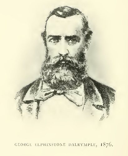
George Elphinstone Dalrymple, 1876
{Page 425}
Rapid Progress of Cooktown and Occupation of Palmer Goldfield. Roads from Port to Field. Mulligan leaves Cooktown, 1st May. A Previous Expedition. Gold on Heads of Kennedy (or Laura?). North Palmer River. Palmer River. Serious Encounter with Natives. Palmerville and Commissioner's Upper Camp (Edwardstown). Leaves Edwardstown, 4 June. Oaky and Sandy Creeks. Oaky Creek overcrowded. Diggers from Upper Palmer pushing up Sandy Creek. Party on Gold at Pine Creek, 13 June to 9th July. "Payable Gold" defined. Proximity of Cannibal Creek Tin Mines. Start Southward and cross Divide to New River (St. George). Gold, but not enough. Up and down the St. George. Its Junction with the Mitchell. Dogged by Diggers. Camp on Mitchell near Limestone Creek. Heads North-westward for Palmerville. The Anglo-Saxon Gold Mine. Gold On Mitchell Side of Divide between Mitchell and Palmer. Reaches Palmerville, 27 July.
WITHIN nine months of the first "rush" the settlement of Cooktown and the new Palmer Goldfield had made rapid strides. The record of Mulligan's "second" trip is chiefly valuable for the light it throws on the new activity, and only the concluding portion shows that he broke new ground.
There were soon two roads from Cooktown to the Palmer, the first, the dray road, or Coward's Track, being practicable for wheel traffic to within 15 miles of the goldfield, and the second, or Douglas's Track, "a good bridle track in fine weather." (See MAPS E and G.) Both roads made for the heads of the Normanby, the dray road, up the westmost branch, which afterwards came to be named Lake Creek (after Captain Lake, of the A.U.S.N. Co.) and Douglas's Track crossing Cox Creek (now called the East Normanby) and the West Normanby. (See MAP G.)
Mulligan left the Four-Mile Camp, Cooktown, on 1st May, 1874, by Douglas's Track and diverged towards tributaries of the Kennedy (as he says, though it seems more likely that they were Laura waters) where he got gold, but not in payable quantities. He then spent a few days on the "Left-Hand Branch", or North Palmer River, camping at the highest point which he had reached on the first trip.
Leaving the North Palmer on 23rd May, Mulligan camped on the Palmer proper on the 25th. On the 27th, while he and his party were prospecting down the river, they were attacked by blacks. "After being three times repulsed," he writes, "they made a furious rush at us as we were leaving the camp. I never saw blacks so determined. The long grass, scrub and high ridges were greatly in their favour. Three of us got marked by them. They will, however, for the future, know the effect of the rifle in that locality." The most seriously wounded of the party was a man named Peter Abelson, and he was reported, eight days later, to be nearly well again.
At this time Palmerville was the headquarters of the Gold Commissioner (Howard St. George), [1] and Edwardstown, between the Palmer and North Palmer, and north of the present township of Maytown, was the "Commissioner's Upper Camp." Mulligan visited both camps, and left Edwardstown on a trip to the Mitchell Valley on 4th June.
[1) Mr. St. George was appointed Police Magistrate at Cooktown, and Mr. P. F. Sellheim became Warden of the Palmer in July, 1874.]
Crossing the Palmer where Maytown now stands, the party crossed Oaky Creek, a tributary of Sandy Creek, and cut the latter about 20 miles above its confluence with the Palmer, and camped on 13th June at Pine Creek, one of the heads of Sandy Creek. Payable gold was got in both these localities. Incidentally, Mulligan defines "payable gold", i.e., gold which it would pay the party, under then existing conditions, to stop and work, as "not less than 1 oz. per man per day." He mentions that "all the branches on Sandy Creek are now occupied by people too late for Oaky Creek; they are in most cases getting good gold . . . I am told that men are now leaving the Upper Palmer, where some are making 2 to 3 oz. per week . . . The lower part of Sandy Creek has been worked for months, and considered poor; the people are now making their way upwards." He also refers to "numerous good-looking reefs for gold right opposite Oaky Creek."
Mulligan's Camp on Oaky Creek was about 6 miles west of the subsequently discovered Cannibal Creek tin lodes.
The horses were suffering from the cold in the high land at the Pine Creek Camp, and Mulligan gladly left it on 9th July, and crossing the divide to the south, dropped down on "Mitchell Waters." It was not, however, the Mitchell itself which was first met with, but a large tributary coming from the east on which the name of the St. George River was bestowed. The new river was prospected upwards for "a few days", but no other indication is given of the distance traversed. gold was found in it everywhere, but not enough to be payable. Returning down the river, they came on a party who had been following their tracks under the belief that they were on good gold.
The St. George River [1] was then followed down to its junction with the Mitchell, with similar results as regards gold. The Camp of 20th July was on the Mitchell, 4 miles below the infall of the St. George, and therefore probably about the infall of Limestone Creek from the north.
[1) The popularity of the first Gold Commissioner on the Palmer led to his name being conferred on another "St. George River", a tributary of the Kennedy.]
Mulligan left the Mitchell on 22nd July and turned northward, prospecting till he reached the watershed between the Mitchell and the Palmer. In some of the gullies he found a "tolerably fair show of fine gold." Apparently his course was far enough west to miss the Anglo-Saxon Reef (Groganville), which, about 1887, was a considerable producer of gold. From the divide he came straight in (NW.) to Palmerville, via Limestone Creek, [2] "to see after fresh horses", arriving on 27th July, 1874.
[2) He left Limestone Creek, which falls into the Mitchell, and arrived at Limestone Creek, which falls into the Palmer. I have had frequent occasion to protest against the senseless duplication of place-names, which disfigures Australian maps.]
{Page 428}
Leaves Palmerville. Pine Creek. Busy Diggers. Progress of the Rush. Tought's Butchery and Store. Range between Palmer and St. George. Prospects for Gold on St. George Fall. Tin on Tin Creek. Crosses St. George and Mitchell Rivers. Cattle Country. Hodgkinson River named. Mount Mulligan. Coal and a Railway. Timid Natives. Alluvial Gold, but Nothing Payable. Site of Thornborough, now Centre of Hodgkinson Gold-reefing District. Little Hodgkinson River. Why was such a Country Created? Walsh River. Hot Springs. Down the Walsh. West of Hann's Furthest East. Was Edwards before Hann? Bowler Creek. Nolan Creek. Sandstone Tableland. "Taylor's Carboniferous Range." Difficult Descent. Back to Palmerville.
AFTER a stay of ten days in Palmerville, Mulligan again set out on 6th August, 1874, with the intention of extending his observations in the valley of the St. George River. About White Horse Creek, he left the track by which he had approached Palmerville on his second trip and shortly afterwards, on an ESE. course crossing McGann Creek, reached, on 10th August, a camp where he had already worked, "getting a little gold". This must have been Pine Creek, on which he camped from 13th June to 9th July. So rapidly had occupation progressed that the site of that camp was now covered by "Tought's butchering establishment" and store, and all the surrounding gullies were being worked for gold, including some which drain into the St. George. Among the latter was Fine Gold Creek, which is shown on the 4-mile map. Mulligan, who had evidently intended to pick up a little more gold here, confesses to a disappointment that the rush had set in so soon.
Having procured two fresh horses at Tought's camp, Mulligan and his party left on 13th August, and keeping on the whole a little to the south of east, crossed the watershed between the Palmer and St. George and prospected the drainage area of the latter river up to 24th August, when they camped on tin Creek. The country was so rough that it was frequently necessary to travel 30 miles to gain 10. Every gully contained gold, "but not enough to satisfy us".
From a main camp on Tin Creek, which they named, they followed the creek north for 20 miles, to near its head, where they found, besides a little gold, "a fair show of tin", but Mulligan observed, "when we consider it would take three tons to pay the carriage of one, better leave it alone, and try to find it over the eastern falls towards the coast near the Daintree, where carriage will not be such a consideration." A belt of granite country, containing tin lodes, is now known to extend from the divide where the South Palmer and Tin Creek (of the St. George) take their rise, westward to the head of Cannibal Creek.
On 29th August, the camp was moved 8 miles south, to where Tin Creek falls into the St. George River. A little gold was found in the St. George here. In two days (30th and 31st August) to the south, the party struck the Mitchell River. This watershed must have been crossed only a mile or two east of Hann's furthest eastern point, which he reached on foot on 29th July, 1872, the country being too rough for horses. From the greatest elevation reached, a "notable landmark" descried to the southeast was the tableland to which the name of Mount Mulligan was afterwards applied. The Mitchell valley at the camp of 31st August and 1st September is described as "fine cattle country." The hoof-prints of four cattle were seen north of the river, and a day was spent in an (unsuccessful) hunt for beef. Probably the cattle had been dropped from some travelling mob, as by this time cattle had begun to be driven from every possible source towards the Palmer, where they commanded high prices.
The camp on the Mitchell must have been very near the infall of the Hodgkinson River, which was met with early on 2nd September. The river was named in honour of W. O. Hodgkinson, M.L.A. [1] The Camp of 2nd September was 6 miles up the Hodgkinson River (ESE.) and at the foot of the tableland, the "notable landmark" of 31st August, which the other members of the party insisted on calling Mount Mulligan. This tableland, overhanging the Hodgkinson valley, extends south-eastward from the junction of the Hodgkinson with the Mitchell for 23 miles, is apparently of Permo-Carboniferous age and consists mainly of horizontal beds of sandstone, with a seam of coal. For the connection of this coal with metallurgical works on the heads of the Walsh and at Chillagoe, a railway has now been built from Dimbulah, on the Chillagoe line. [2]
[1) Hodgkinson had been a member of the Burke and Wills Expedition, 1860-61, and crossed Australia in 1862 with McKinlay. In 1876 he led an expedition from Cloncurry to Lake Coongi, in South Australia, and by the western boundary of Queensland to the Gulf of Carpentaria, thence to Brisbane via Normanton, the Cloncurry and the Flinders (Meston's Geographic History of Queensland, p. 209). He was afterwards a Goldfield Warden. Having entered Parliament, he became Minister for Mines in the Griffith Government in the late "eighties".]
[2) See "Report on Mount Mulligan Coalfield", by Lionel C. Ball, B.E. Geol. Survey Publication, No. 237. Brisbane, by Authority, 1912.]
On 3rd September, Mulligan went 18 miles up the Hodgkinson, south-eastward, passing the infall of the Eastern Hodgkinson. Up to this camp he describes the valley as "fertile" and "comprising the best and richest soil I have seen anywhere." He got "colours" of gold on the bars.
Proceeding on the same course up the river on 4th September, he found that in 2 miles it branched. Presumably, this was where Caledonia Creek, and another creek rising west of Mount McGann, fall in. Following the river itself for 5 miles SE., he camped "at another junction", i.e., at the infall of the creek followed to-day by the Dimbulah-Mount Mulligan Railway. This Camp was about 2 miles south of the site of Thornborough, which afterwards became the centre of the Hodgkinson Goldmining District. Here they saw natives, "but," says Mulligan, "they soon hide from sight. They are wilder than kangaroos. They run from their camps, and leave many little things behind."
Next day (5th September), all hands prospected the neighbourhood for alluvial gold. "Colours" and "shotty specks" were the only reward of their labour, and the verdict was that "there was no prospect for anything payable here only for fattening cattle." An amusing instance of how Mulligan's views were coloured by his disappointment, or perhaps of his habitual attitude of being bored to the point of incoherence by mere scenery, occurs in his observation: "We are disgusted with the sight of such nice round hills and mountains passed by, and yet no show of gold or even quartz."
In the beginning of 1877, attention began to be directed to the Hodgkinson as a reefing district, and it may be mentioned incidentally that Mulligan was one of Thornborough's earliest business men. Exceedingly rich crushings were obtained from numerous narrow shoots, but after ten or twelve years the industry languished. It never, however, quite died out, and recent indications appear to promise for it a renewed lease of life. Details of the geological structure and output of the field will be found in the reports quoted below. [1]
[1) "Report on the Hodgkinson Gold Field, with Two Maps", by R.L. Jack, Government Geologist. Parliamentary Paper. Brisbane, by Authority, 1884. "Notes on the Present Condition of the Hodgkinson Gold Field", by R.L. Jack, Bull. No. 4 of Geological Survey. Brisbane, by Authority, 1896.]
On 6th September, 1874, the Party left the Hodgkinson proper, and struck NSW [sic]., camping on "a large tributary", probably the "Little Hodgkinson" River. Next day (7th September) "a few miles to the SW." brought them into very difficult country between the Hodgkinson and the Walsh. "I never beheld such rough country before", says the Leader. (See MAP K.)
On the 9th, the party scrambled up a spur which they had discovered after much anxious search, and were at last on the southern, or Walsh side of the watershed. On the 10th, although they "kept well on the range", travelling was even more difficult than on the 7th. "In all my travels," Mulligan remarks, "I never saw such rough country as to-day. All porphyry, intermixed with sandstone, therefore it is not slippery, otherwise the horses could not get along. I cannot see to what earthly use this country can be turned. Such a solid block of country, of about 50 miles across by 100 miles long, stretching longways from within a few miles of the Mitchell towards the head of the Lynd; too rough and stony, destitute of grass, not even enough for a kangaroo!" Nevertheless, he reached and camped on the Walsh in the afternoon. The precise position of this Camp cannot be given, though it might easily be located, if one were on the spot. I take it to be about 6 miles down the river from the infall of Emu Creek. [1] It could easily be located by the almost boiling spring which Mulligan found beside it, and no doubt the spring is known to many of the wolfram, tin, copper and silver miners a population ever prone to wandering and prospecting—now resident within easy reach of it at the Wolfram Camp, Lappa-Lappa, Koorboora and Chillagoe.
[1 Till recently, Emu Creek was only known as the "Third Walsh."]
Trying next day (11th September) to follow the course of the river downward to the west, the party travelled 12 miles, but had to turn back some distance to find a crossing, as the valley had narrowed to an impassable gorge, so that probably the actual westing was comparatively small. The Camp was on a little patch of green feed, beside a boiling spring. On the 12th, the river was followed down for 15 miles, and the frequent human footprints seen proved the native inhabitants to be numerous.
| TL W M A H X X I and the other CR. 1871 A X X I I |
On 14th September, Mulligan ran the Walsh down, and left it at a reach which bent to the south. He then, for a short distance, followed up a creek (Bowler Creek?) which fell in on the right, or north, bank, but as he wished to go north-west and the creek was taking him to the east of north, he left it and struck out north-west, following a high ridge of granite boulders. The country lately traversed is dismissed with the curt remark: "No gold here". He camped on the 15th on a gully falling to the north, towards the Mitchell, as he supposed, but which must have been a tributary of Nolan Creek.
On 16th September, Mulligan travelled NNW. and camped on a "big watershed" with sandstone cliffs to north and south. [For "watershed" it is necessary to read "water-course", as a close acquaintance with Mulligan's writings shows that he was careless in the use of the former word.—R.L.J.] The water-course must have been Nolan Creek, a tributary of the Walsh.
On the 17th, he went north to the Mitchell River, which he struck near the mouth of the "Dry River" (the "Dry River" which heads near the O.K. Copper Mines). He had great difficulty in getting down off the sandstone tableland (Taylor's Carboniferous Range of the Hann expedition), and compares the descent unfavourably with that on the Hell's Gate track between the Normanby and the Palmer. Between the cliffs and the Mitchell, he must have crossed Hann's track of 28th July, 1872.
After stopping two days at the Mitchell to recruit the energies of men and horses, both tired and worn, the journey was resumed, and Palmerville was reached, via Mount Mulgrave, on 21st September, 1874. No details are given of this portion of the journey, which was now familiar ground.
As already stated, Mulligan's intention when he left the Palmer was only to see the St. George River above the point reached on his previous visit, but the fascination of his pursuit took him much further. The "notable landmark" now known as Mount Mulligan drew him like a magnet, and at the foot of that mountain he discovered the Hodgkinson River, a large affluent of the Mitchell. From the site of the present town of Thornborough, on the Hodgkinson, he then crossed a rugged range to the Walsh River near the infall of Emu Creek. Finally he traced the river downward till he was west of Hann's "furthest east", and returned to the Palmer.
{Page 433}
Short Unsuccessful Tour North-west and North of Palmerville. On the Sandstone Tableland. Kennedy River and Macmillan's Road. Little Kennedy River and Mackenzie's Road. Fresh Start from Palmerville, 22nd October. Up Mitchell River and up St. George River to its Head. Gold on St. George. Southward to New River, named the McLeod, A Tributary of the Mitchell. Gold in McLeod River and Escape Creek. Natives. Up Spencer's Creek, a Head of the McLeod. Hunting for Beef. Across Range to Head of Palmer. Down the Palmer. Gold begins to appear. Native Camps. Northward across Heads of Palmer and Little Palmer to Laura Valley. Project to Prospect the Daintree considered. Could be done by Party fitting out at Cooktown. Extravagant Cost of fitting out at Palmerville. Recross Dividing Range to Little Palmer, 19th November. Prospecting. Gold, but no Water. Excursion to Heads of Normanby. Long Dry Stage. East Normanby River (Cox Creek). Near Hann's Track. Impossible to go East to Blomfield River. Down the East Normanby. Gold, but no Water. Dry-blowing. Find Jack Watson, an Old Mate, working on Gold. A Rush defeated. Stacking Washdirt. Return to Camp of 19th November. Two Men go to Cooktown for Stores. The Others set out for Palmerville. Gold At Head Of Little Palmer And In The Palmer River Around Byerstown, and not yet tried by Diggers. Doughboy and Penrich Creeks, where Gold had been worked. Uhrstown. The South Palmer. Gold. Granite Creek. Sandy Creek. Back to Palmerville, 5th December.
MULLIGAN left his camp, near Mount Fox, about 10 miles below Palmerville, on 1st October, 1874, and spent about a fortnight on a prospecting tour to the west and north. He crossed Big Creek and Stewart's Creek and camped on 2nd October at a hill which he estimated to be 22 miles W. 30° N. of Mount Daintree. The bearing is no doubt correct, and assuming the correctness of the distance, the camp would be on the north side of Annie Creek, about 7 miles west of Hann's track between his 20th and 21st camps. He got "colours" of gold, but places which appeared promising could not be prospected for want of water. The camp of 3rd October was 8 miles NNE. at a spring on Hann's track, north of his 21st camp. Mulligan then ascended the sandstone tableland known as the "Conglomerate Range", and here, of course, the prospect of alluvial gold ended. The whole of the country to the west, visible from the summit, was ablaze with fires lighted by the natives. About 11 miles east of the encampment, "Macmillan's Road" from Cooktown to Frome and Palmerville, following up the Kennedy River, was crossed, and 10 miles further east, "Mackenzie's New Road", which follows up the Little Kennedy River by Hann's return track of 1872 (Camps 74 to 76). As neither the Kennedy nor the Little Kennedy had carried the process of erosion down through the horizontal sandstone to the underlying auriferous foundation, the quest for alluvial gold was abandoned and Mulligan and his party returned to Palmerville.
A fresh start was made on 22nd October, and the Mitchell River was reached, via Mount Mulgrave, on 24th. This camp on the Mitchell was probably a little above that of 17th September (3rd trip).
From this point the party travelled and prospected up the St. George River to the camp of 29th August, at the infall of Tin Creek, which was reached on 28th October. "A little gold" was obtainable anywhere in the river and the presence of "good looking quartz reefs" was noted. Travelling up the river on 30th and 31st October, "good-looking country for gold" and "numerous quartz reefs" were observed on the south side. On the latter date the river, flowing through slate country, was hemmed in by granite mountains forming the divide between the St. George and the Palmer on the north and the McLeod on the south.
On 2nd November, to SSE. with "really good travelling" and "magnificently grassed country, level box flats, open forest", the party reached a river, which at first was taken for the main Mitchell, but was afterwards ascertained to be a branch and named the McLeod, after one of the party. The Camp for the night was where, on following the river up, it bends, according to the modern map, from north-east to south-east. A creek falling in from the north side, probably Escape Creek, was prospected. Mulligan mentions that in crossing the river, which was chest deep, they stripped to the skin and waded. "Our appearance," he observes, "must be very annoying to the darkies, as well as theirs is to us, for they immediately abandoned a laborious piece of work they were engaged at, in making a wing-dam across a back bend or wing of the river in order to poison the water with branches and leaves to catch fish." The creek yielded "a little gold, but not enough to pay, and also a little tin." Mulligan remarks on the magnificent soil and vigorous growth of trees on both the creek and the river. "Colours" of gold were got in every dish on the river itself.
On 3rd November, Mulligan and his companions continued their journey to the north-east, at the branch which the modern map calls Spencer's Creek. They made the camp near the head of this creek their headquarters till 8th November for various reasons. A horse was lame, Mulligan himself was not feeling very well, and it rained every day: prospecting, fishing and shooting took up some time, and finally there was the sport of tracking a bullock. This hunt for beef, though unsuccessful in its primary object, resulted in the locating of the Mitchell River 12 or 14 miles south of the camp, and also some quartz reefs, which, however, were not of a promising aspect.
On 9th November, the party climbed, in 2 miles, northward to the top of the watershed between the McLeod and the Palmer. The ascent is described as being "higher and four times worse than Hell's Gates, on the road to Cooktown." Outcrops of limestone were observed on the summit. The Camp for the night was at the first water on "the extreme head" of the Palmer, apparently the head named Prospect Creek on the modern map. There was no quartz in the hills and no gold at the camp.
The party, next day (10th November), went 11 miles WNW. down the Palmer (Prospect Creek), which would make the camp midway between Piccaninny and Stewart Creeks. On 11th November, a further distance of 9 miles was accomplished, and for the first time water was observed in the river, which received it from "a narrow boggy creek", presumably the Boggy Creek of the modern map. Quartz had now begun to appear, and "shotty gold", but not enough of it, was found in the river as well as in gullies and ravines near the camp.
The Camp of 12th November was 6 miles further down the river (NW.). The two following days were spent in prospecting, but as water was for the most part not available, the men had to be content with "dry-blowing", and although "colours" of gold were obtained, nothing remunerative was found. The fires of four native camps were seen above this camp.
On 15th November the party left the Palmer and went north for 9 miles. On the 17th, they camped beside an old native camp, where a spring issued from basalt, on the eastern fall, near the head of the Hearn or Laura River, after having headed the "Little Palmer" River. In crossing from the Palmer valley to the head of the Little Palmer, it was found that the granite range which had, down to this point, formed the north-eastern wall of the Palmer valley, continued to the north or north-west, while the divide between the Little Palmer and the Normanby was a comparatively low range of basalt. From a peak near this camp, Battle Camp Range was visible to the north (45 miles) and Mount Peter Botte to east-south-east (40 miles).
In this camp it was hotly debated whether the expedition should return to Palmerville or go eastwards to the Daintree. It may be remembered that all they could have known of the Daintree was the situation of its mouth, as determined by Dalrymple the year before. Mulligan himself favoured the former course, having observed from his peak that the country to the east was extremely rough. He concluded that it was better to tackle the Daintree with rations purchased at reasonable prices in Cooktown than with an outfit from Palmerville where flour, for example, cost £20 per bag. Fortunately, the other members of the party were convinced by the sweet reasonableness of this argument.
On 18th November, Mulligan recrossed the dividing range, and, after passing over "beautiful quartz ridges", camped on a "big sandy creek" (a tributary of the "Little Palmer").
Next day (19th November), a Camp was formed 7 miles to the west, for a few days' prospecting. Fine gold was got in the neighbouring gullies, "but not sufficient to pay at present, water being scarce."
On 23rd November, Mulligan and four others started on an excursion with the intention of prospecting the heads of the Normanby River. That day they travelled 30 miles east before they got water for a Camp, probably in Storing Creek, one of the heads of the West (middle) Normanby. Next day (24th November), they moved camp eastward across a low range to "another and larger branch", which must have been the "East Normanby or Cox Creek, as bearings taken from an adjoining hill showed Mount Cook to lie N. 10° E. and Mount Peter Botte ENE. They had been travelling parallel to, and a few miles to the north of, Hann's course between his camps 57 and 59. Two of the party went east, but reported that it was simply impossible to get the horses to the Blomfield in that direction. The mouth of that river was about 15 miles, and the nearest part of the river about 11 miles from the camp of 24th November.
"Colours" of gold could be obtained in the gullies within reach of the camp, but there was no water for prospecting purposes.
The party moved NW. down the East Normanby River on 25th November, finding by the way prospects of gold, which, although they could only "dry-blow", they judged would be payable after the advent of the rains, especially as outfit and provisions could be purchased economically at Cooktown, instead of costing the prohibitive Palmerville prices. A little lower, they came on an old mate, Jack Watson, who was himself "getting a little gold", and informed them that a little rush had already taken place, but that most of the men had left for want of water and grass. One party was still working up a gully, stacking washdirt to be ready for the rains.
On 26th November, the excursion party returned to the main camp of the 19th.
Two of the party were now despatched to Cooktown for a load of stores, and on 27th November, the main body commenced the home journey to Palmerville. Now almost within sight of his goal, Mulligan's diary becomes somewhat careless as regards directions and distance travelled. The party camped the first night after going 8 miles, presumably southward, to the "main" Palmer River, passing "good-looking gullies, in some of which could see a little fine gold on the bars", which had apparently been missed by the diggers. They worked hard for two days, and located gold which no doubt would have been payable under more favourable conditions, but as they had only tin dishes and had to carry the dirt a long way to water, they were "not quite satisfied" with their earnings. In the afternoon of the second day (29th November), they shifted 4 miles to another creek, "on their way", and therefore probably Blackfellow Creek.
The 30th November was spent in prospecting here, with similar results.
On 1st December, keeping a few miles out from the left bank of the river, mainly NW., the party, after travelling deviously for 15 miles, over slate formation with numerous outcrops of quartz reefs on every hill, camped again on the Palmer River, probably about 2 miles below the site of Byerstown. It may be added that the country traversed by Mulligan, 27th November to 1st December, 1874, was occupied, during the wet season which followed, by diggers who grouped themselves around the new township of Byerstown, of which Byers and Little's butchery formed the nucleus, a convenient fattening ground for cattle being situated on the head-waters of the Laura.
On 2nd December, 2 miles to the SW., the party found Doughboy Creek, which had already been named by a party who had worked gold in it. Mulligan's idea was that their neighbourhood was workable at a profit by parties obtaining their stores direct from Cooktown instead of through the medium of Palmerville. He camped for the night, after 15 miles of travelling, at what he called Penrich Creek, probably the South Palmer. The diggers who subsequently worked out this neighbourhood established the township of Uhrstown.
On 3rd December, over rough country where he "had to go 5 miles to gain 3", Mulligan travelled 16 miles to WSW. A little gold was to be got, and had there been water he would have stopped, as he thought well of the country, and it had evidently been little prospected. This must have been "Granite Creek".
On 4th December, Mulligan travelled 27 miles westward to Sandy Creek. Palmerville, 18 miles further west, was reached on 5th December, 1874.
For Mulligan the Palmer had by this time gone stale, and he pined for new fields. He could not get out of sight of landmarks with which he had already become familiar. "To me it is a pleasure," he writes, "to traverse and gaze on new country where no human foot ever trod or gazed(!) before. Every step discloses new scenes and fresh discoveries . . . The fascination, as well as the charm, is broken once I return to ground travelled before, though I expect more gold."
{Page 439}
Government Assistance. Mulligan's Companions. His Equipment. His Official Report issued without the Explanatory Map. Leaves Cooktown, 20th April, 1875. Coward's Track. Normanby Diggings. Lake Creek. Country occupied on Head of Laura. Over Range to the Palmer. New Track now used by Diggers. Across the St. George to the Mitchell River. Eastern Hodgkinson River. Camp 7. New Auriferous Country. Up Moran Creek. Gold. Through Hann's Range to the Barron. The Head of the Mitchell River. The Barron formerly the Head of the Mitchell. Geological Cause of Alteration of its Course, Erosion of Gorge and Discharge into Trinity Bay. Alluvial Plain common to the Barron and the Head of the Mitchell. The Party explore East of the Barron. Discover Gold, which subsequently proved to be Payable. Tinaroo Diggings. Basaltic Country. Recross to Left Bank of Barron. Rich Scrub Lands. Cedar, Kauri Pine and Stinging Tree. Native Tracks and Dwellings. Atherton. On the Range where Barron, Herbert and Walsh Waters divide. Camp 21 at Moomin on Wild River (Head of Herbert River). Discovery of Tin Ore. Beginnings and Progress of Tin-mining Industry. Extension of Railways through New Mining District. Herberton. Jack and Newell. John Moffat. Down the Wild River. Cross New Road from Cardwell to Palmer. Newellton. Leave Wild River for Mount Surprise. Nettle Creek (Tin). Innot Hot Springs. Return Creek (Tin). Mulligan now recognises the Wild River to be the Herbert, having previously regarded It as the Head of the Barron, which he mistook for the Mitchell. Pastoral Land. Poison Plant and the Horses. Mulligan Creek. Expedition Creek. The So-called "Great Dividing Range". The Lynd River. Leichhardt's Tracks. St. Ronans Station. Known Landmarks. Old Fossilbrook Station. Hann's Starting-point. Mount Surprise Station. Arrive at Junction Creek Telegraph Station and report to Brisbane. Effects of Poison Plant on Horses. Native Depredations among Station Horses.
IN four trips, on the first of which he proved that the gold first discovered by Hann on the Palmer River was present in payable quantities, Mulligan had exhausted the attractions of the district, for he was a man who could not be happy as long as he was in sight of a landmark already known to him.
These four trips were undertaken at his own expense, or at all events without aid from the State, although it is possible that some of his companions may have contributed towards the cost of the outfit. The remuneration which he and they shared was the Government reward of £1,000 for the discovery of a payable goldfield, added to what gold they found time to pick up. Compared to what fell to those who followed his tracks and systematically worked the ground, Mulligan's own share was infinitesimal.
In his fifth expedition, Mulligan was assisted by a Government subsidy of £500. His companions were Frederick Warner (afterwards Staff Surveyor, Department of Lands), James Dowdall, William Harvey, Peter Abelson, Jack Moran and the black boy, Charlie. Abelson had been with Mulligan on his second expedition and had been wounded by the blacks.
The record of the expedition is a Parliamentary Paper entitled "Expedition in Search of Gold and other Minerals in the Palmer District by Mulligan and Party." (Brisbane, by Authority, 1876.) The party returned to Cooktown on 23rd September, 1875, and Mulligan sent an abstract of his report on the 24th to the Minister for Works and Mines. In that abstract and in the report itself, as finally printed, reference is made to a map to be prepared by Mr. Warner as an essential adjunct to the report; but the report appeared without the map.
As the map was obviously of high importance (indeed, in my view of no less importance than the report itself), I instituted inquiries, and Mr. A. B. Brady, the present Under-Secretary for Works, who was good enough to interest himself in the matter, unearthed a correspondence, from which it appeared that as late as 27th March, 1876, the map had not been prepared. Mulligan, writing from Cooktown on that date to the Under-Secretary, said: "Mr. Warner is going to Brisbane in a few days; he being our Surveyor will be able to furnish you with all the information required, and plot a chart of the whole route." In the same letter, Mulligan forcibly insisted on his report being officially published, observing, "to have my journal shelved for a departmental record without giving me time or opportunity to copy and correct it, is more than I would barter for half the amount received by the whole party."
The report was officially issued later in the same year (1876), but without the map, which either had not been received in time, or was not considered of sufficient importance to justify the expense of drawing it on stone. Mulligan had quite correctly gauged the official attitude of the time with regard to reports which had no political significance. They were "given to the newspapers", and were printed in full if the "demands on our space" permitted, or, if not, a sub-editor extracted such portions as he judged would strike the popular taste. The same policy was still in vogue when I arrived in the Colony in 1877, and resulted, among other things, in the loss of the map which was to have accompanied the report on my explorations of 1879-80 in the Cape York Peninsula.
Having become convinced that Mulligan had intentionally left much to be explained by the map, I made an effort to trace the latter, and I am indebted to Mr. A. R. Macdonald, lately Undersecretary for Mines, for a copy of a record of the Department of Lands (Survey Branch), inscribed as in the footnote. [1]
[1) "Tracing of Sketch Map showing the Position of Hodgkinson and Palmer Goldfields, compiled from Survey of Road from Cooktown to Palmerville and Explorations by Dalrymple, Hann and Mulligan. June, 1876. Scale 8 miles to an inch.
Note: Mulligan's Track shown thus —·—·—·—·Mulligan's Second Track shown thus —⋅⋅—⋅⋅—⋅⋅—⋅⋅ 1875.
The information was traced from Plan in Survey Office, Cat. No. C. 153-6. E.F.E. 4.1.15."]
It is evident that Warner's map was received between 27th March and — June, 1876, as from no other source could the information relating to Mulligan's explorations have been derived. The lines of alternate dot and dash showing "Mulligan's Track" depict first that portion of his fifth, or official, journey lying between the head of the Palmer and (via the heads of the Mitchell and Wild Rivers) the "main divide" between the Herbert River and the Lynd, and second, that portion of the same journey from the confluence of the Lynd and Mitchell to the Lukin (Holroyd) River and thence to the Normanby River north of the present "Welcome" Railway Station. The line of dash and two dots showing "Mulligan's second trip, 1875", depicts only 32 miles (from the Hodgkinson River northward) of what I have described as the "third" trip (1874).
It was gratifying to find that the track of the fifth or official trip, so far as the tracing showed it, agreed in a remarkable manner with the track as laid down by me from the narrative before the tracing came into my possession. The only differences were due to my having much more complete maps to work on than were available to the compiler of June, 1876.
The tracing throws no light on Mulligan's four previous trips, the first of which led directly to the opening of the Palmer Goldfield. So far as I am aware their tracks are now for the first time laid down on the maps accompanying this volume.
The party left Cooktown with twenty-two horses, on 29th April, 1875, and travelled via the Four-mile and "Coward's Track" to the Normanby Diggings. (See MAP E.) Coward's Track, as already explained, is the westmost of two roads up the Normanby valley, and follows the head known as Lake Creek. (See MAP G.)
"The Normanby Country, as well as the Heads of the Laura", says Mulligan, "is about the best country to be seen in the north. Little and Byers are running their fat cattle on the extreme east head of the Laura. Here we stop to cure sufficient beef for our trip. Paid £30 for a bullock, which, with 200 lb. ham and suet, we reckon will do us for a few months."
After a delay caused by the loss of a horse, Mulligan led the party on 11th May from the head of the Laura up the spur of the Coast Range discovered by him on 26th November, 1874, when he had noted that it would be suitable for a dray track. It was already, he now found, "used by diggers coming down from the Palmer."
Keeping a general southerly course, Mulligan crossed the Palmer and St. George Rivers and camped on 16th May on the bank of the Mitchell. Camp 6. As this region was already familiar to him, Mulligan only remarks that "a good dray road can be got, every perch of which we travelled." A dray road does now follow his track, connecting Woodville, on the Hodgkinson, with Cooktown, via Uhrstown. Mulligan's route from the Mitchell to the eastern branch of the Hodgkinson coincided with the dray road as laid down on the modern map. His Camp 7, of 17th May, on the Eastern Hodgkinson, was near the mouth of McLeod Creek. He was now on auriferous ground hitherto unknown, and on prospecting got a little gold.
Travelling a mile or two south of the left bank of the river, Mulligan continued next day to get "colours of gold", and camped on the left bank about 2 miles east of Moran Creek. Camp 8, 19th May.
Next day (20th May) he followed up Moran Creek, which he took to be (and which perhaps is) the largest head of the Eastern Hodgkinson, in a NNE. direction, getting only "colours" of gold. His Camp 9, on Moran Creek, he judged to be 13 miles from Camp 8, but it is evident that the difficulties of travelling and delays for the purpose of prospecting caused him to overestimate the distance. In 15 miles SSE., on the following day (21st May), he reckoned that at his Camp 10 he had at last got clear of the Hodgkinson waters. He was probably about the head of Roman Creek. [1]
[1) Called after "Sam the Roman", a Roumanian, afterwards a well-known Hodgkinson "identity."]
East of the heads of the Eastern Hodgkinson lies the granitic mass which Mulligan named Hann's Range, and which runs from NNW. to SSE. Mulligan now made to the east for a gap in this range, beyond which he confidently (and correctly) hoped to find the head of the . He did, indeed, find it, but crossed it without being aware of the fact. His Camp 12, of 23rd May, was on the Mitchell, "close to a new mia-mia of the darkies", and he "hoped to see the Mitchell to-morrow." The camp was in "open forest country, more like a meadow, traversed by numerous deep creeks, with a stream of water in each, and it was difficult to find a stone for an anvil to punch horses' shoes on." This fine country, hitherto untrodden by white men, excited his admiration, and although mere scenery left him cold, he foresaw its value for pastoral purposes.
A few years later, I had occasion to become very familiar with this district, and to my surprise I found that the head of the Mitchell is actually in this "meadow"—a stretch of alluvial plain common to the Mitchell and the Barron Rivers, the latter of which carries a great volume of water. An extra high flood in the Barron would send the surplus water of that river down the Mitchell. The conclusion was inevitable that the Barron was once actually the head of the Mitchell. Geological investigation showed that at no very remote date (probably Tertiary) this portion of the Barron valley was raised by the accumulation of thick coulées of basaltic lava to a level which enabled the river to escape through a gap to the east, and this was followed by the erosion of the stupendous gorge commencing at the famous Barron Falls, and the Barron became an independent river, discharging into the Pacific at Trinity Bay instead of into the Gulf of Carpentaria, as it had previously done. The railway line from Cairns, Trinity Bay, to Chillagoe, Mount Mulligan, the Etheridge and Herberton, now climbs up the southern side of this gorge, and besides subserving the industrial purposes for which it was designed, carries crowds of tourists to the Falls, the unrivalled jungle scenery and the health resorts of the district.
Mulligan struck the left bank of the Barron on 24th May (Camp 13) near the point where the course of the river abruptly changes from north to east. Without a suspicion that the river was not the Mitchell, he was naturally amazed that it should still, so far above where he had previously crossed that river, be a river of so much importance and carry such a large body of water. Believing it to be the Mitchell he emphatically declared the Mitchell to be "the river of Queensland."
Mulligan's mistake was strictly comparable with Hann's mistake in following the Annan River to its head under the impression that he was following the Endeavour. Both mistakes were not only natural, but inevitable.
Where the Barron was first met with, Mulligan noted the deep, rich, fertile alluvial soil, densely covered with scrub, or jungle; but regretted that it was not "the kind of country in which we expect gold." He named the flats "King's Plains", after the then Minister for Works, the Hon. H. E. King, but the name does not appear to have caught on, and the popular appellation of the "Barron Scrub" seems likely to be perpetuated, although the scrub itself has to some extent been cleared for agriculture, and may in time disappear entirely.
Rain had by this time set in, and the Barron could not be crossed until the 26th May, on which day Mulligan estimated that he made 10 miles to the south-east, over slate country. It may be said here that from the time when he first camped on the Barron till he reached the head-waters of the Wild River the distances given by him are either greatly exaggerated, or his course was unusually tortuous. Camp 14, of 26th May, was some 2 or 3 miles east of the site of Biboohra (now a railway station). A day and a half spent in prospecting in the neighbourhood of this camp gave only "colours" of gold, although Mulligan judged the country to be highly favourable for its occurrence in payable quantities. The voices of natives were heard.
On 28th, 29th and 30th May, the party travelled, mainly southward, for an estimated distance of 25 miles (say 14 in a direct line) to Camp 17 on the Barron River (which Mulligan calls the Mitchell), at a point about 8 miles above the present Mareeba railway junction. (See MAP K.) Only "colours" of gold were obtained. "Floating Basalt" was observed (i.e., basalt in horizontal beds), and a rich chocolate soil.
Although Mulligan's party had not the luck to discover payable gold east of the Barron River, they drew attention to the existence of the metal, and in 1879 a party of miners camped on Tinaroo Creek, actually found it payable, although I believe the alluvial gold was soon worked out.
Crossing to the left (or western) bank of the Barron, 3 miles below Camp 17, the party, on 1st June, rode 8 miles SSW. "over the best table of basaltic country that we have yet met; it is of a dark red or chocolate-coloured soil." Here the edge of the thick scrub barred the way. After a vain attempt to penetrate the scrub, getting stung by the "stinging tree" and observing enormous cedars, [1] a NW. by W. course was followed for 3 miles, when Camp 18 was made on "a basaltic creek", presumably one of the branches of Abbott's or Granite Creek.
[1) A few years later the cedar of this district proved immensely valuable, and was almost entirely cut out.]
Rain and the necessity for a preliminary exploration of the scrub delayed the start till the afternoon of 3rd June, when a native track leading through a narrow passage between the scrub and the granite hills on the west was followed southward for about 4 miles. Camp 19 was on a grassy flat, "where a creek enters the scrub, with deep alluvial banks", probably west of the site of Carbeen Railway Station. In the scrub gigantic kauri pines were observed, and the superior style of architecture of eleven "townships" of the natives was commented on. The "townships" were groups of well-thatched gunyahs, each capable of accommodating five or six persons.
On 4th June, the party first marched for "a few miles" to the south-east, with the edge of the scrub on their left and the granite range on their right. When at length the range on the right was observed to recede westward (which should be about the site of the modern township of Atherton—a prosperous agricultural centre), the course was changed to the south-west. The total stage for the day having been 9 miles, it may be assumed that Camp 20 was between Prior Creek and Scrubby Creek and about 2 miles south-west of Atherton.
On 5th June, the general course was 13 degrees west of south, and the estimated advance 11 miles. Soon after their start, a spur led the travellers up to the top of granite ridges, where, in fact, although they could only guess at the facts, the Walsh drained the western, the Barron the northern and eastern, and the Wild River the southern slopes of the elevation on which they stood. Had Mulligan been as familiar with southern Scotland as I then was, his imagination would have transported him to the "Black Larg", where
Shortly afterwards they found themselves following a river, which after winding to west and east, began to show a general tendency to fall to the south. They camped (Camp 21) on this river, dubious as to their whereabouts, after a tortuous journey of 11 miles. They were on the Wild River, the main head of the Herbert River, which, after running about 150 miles to the south and south-east, discharges into the Pacific opposite the southern end of Hinchinbrook Island, and they must have been on or near the site of the future township of Moomin.
The wet weather which had set in on 23rd May still continued, and the next day (6th June) "being Sunday", it soon transpired that all hands were "willing to camp" for the day, especially as there were six or seven horses to be shod. The delay gave Mulligan an opportunity for prospecting, and he brought back to the camp "a fine sample of tin ore". He reflected: "There may be any quantity of it here, but of what use is it at present, considering the price of carriage? Yet it is well for the future of the Colony to know that there is tin in this locality, and will no doubt be got in sufficient quantity to pay when carriage and other facilities are available, the country being opened up."
This prediction has since been amply justified. The tin-mining industry which commenced at Herberton, 3 miles down the river from Moomin, and spread out far to the west, has done even more for the development of northern Queensland than the discovery of the Palmer Goldfield. In its train has followed the construction of railways from Cairns (Trinity Bay) to Atherton, Herberton, and Tumoulin, Irvinebank, Stannary Hills, Mount Garnet, Chillagoe, the Etheridge Goldfield, Mount Molloy and Mount Mulligan, with a total length of about 460 miles, viz.:—
| Cairns to Atherton | 68 |
| Atherton to Herberton and Tumoulin | 31 |
| Boonmoo to Stannary Hills | 20 |
| Stannary Hills to Irvinebank | 12 |
| Lappa to Mount Garnet | 35 |
| Mareeba to Chillagoe and Mungana | 103 |
| Almaden to Forsayth (Etheridge G.F.) | 142 |
| Biboorah to Mount Molloy | 20 |
| Dimbulah to Hodgkinson G.F. and Mount Mulligan Coalfield | 29 |
| —— | |
| Miles | 460 |
| —— |
The following brief account of the beginnings of the tin Industry is taken from my first official report "On the Wild River Tin Mines", dated 27th October, 1880 [1]:—
[1) "Geological Survey of Northern Queensland. Further Reports on the Progress of the Gold-Prospecting Expedition in Cape York Peninsula." Parliamentary Paper. Brisbane, by Authority, 1881.]
"This neighbourhood was described by Mulligan as stanniferous as much as six years ago, [2] but as there was then no nearer port than Cooktown, the expense of land carriage would, of course, have rendered the working of tin unremunerative. The harbours of Cairns and Port Douglas having, however, at length been opened, and the basaltic regions in the valleys of the Herbert and Barren having been taken up in squatting runs, attention was again directed to the tin deposits. Mr. Atherton, of Emerald End, on the Barron, having found stream and surface tin in sufficient quantities to warrant further prospecting, took up John Newell, and seven others from Tinaroo (about 39 miles off) to the heads of the Wild River in the latter end of 1879. This party found stream tin in payable quantities in Prospectors' Gully, on the left bank of the Wild River, near the present township of Herberton. Four months later, William Jack and party explored the neighbourhood of Prospectors' Gully, and was rewarded by the discovery of the Great Northern lode. Other lodes were quickly found and taken up by the miners, who shortly afterwards rushed the ground."
[2) Five years would have been more nearly correct.]
The discoverers of the Great Northern Mine were Jack, Newell, Joss and Brandon.
It may be added, before concluding this digression, that Messrs. Jack and Newell shortly afterwards opened a general store at Herberton, with branches in the various townships which sprung up in the district later on. In the course of a few years they came to exercise many of the functions of a providence, and by judicious assistance and credit bestowed on the men who were pioneering the new field were potent factors in its development. Mr. Newell represented the district in Parliament for many years. Mr. Jack fell into ill-health, suffering from a peculiar form of asthma which rendered life impossible for him except in such hot and humid climates as are to be found in Cairns, Papua or the Celebes. Even a short stay in the bracing upland atmosphere of Herberton was at last forbidden to him. He died a few years ago.
Shortly after the discovery of the Great Northern mine, John Moffat acquired an interest in it, and was instrumental in establishing tin-dressing machinery thereon. His activities in this direction extended westward with the progress of the mineral field, and he was prominently associated with the inception of tin-dressing plants at Irvinebank, Montalbion, Glen Linedale and California Creek, and with smelting works for lead, silver and copper at Irvinebank, Montalbion, Glen Linedale and Chillagoe, as well as at Mount Elliott (Cloncurry) and with the Chillagoe and Etheridge railway system. In addition to his personal enterprise he was a ready "backer" of any prospector who professed to be on the trail of discoveries in tin, lead, silver, copper, bismuth, molybdenite or wolfram. He was frequently spoken of as the father of tin mining in the north. Prior to his arrival at Herberton, he had been engaged in alluvial tin mining at Stanthorpe since 1870, and had erected the smelting works at Tent Hill on the New South Wales side of the border. Born at Loudon, on the River Irvine, Ayrshire, in 1840, he came to Queensland in 1862, and died at Toowoomba on 28th June, 1919. [1]
[1) For some of the above particulars, I am indebted to a biographical notice by Sir Robert Philp.]
When Mulligan and his party finally started to follow the Wild River southward, on 7th June, 1875, Mulligan and Warner inclined to the belief that it was the head of the Mitchell; that is to say, dominated by the idea that the Barron was the Mitchell, they imagined that it first flowed southward, then eastward and northward (the Barron), and finally westward to the Gulf of Carpentaria. The identity of the Wild River with the Herbert was shortly to be ascertained, but not by Mulligan, if, indeed, it was not already known to the "mute, inglorious" bullock-driving pioneers, who by this time had marked a road from Cardwell to the Palmer.
Passing the site of Herberton about 3 miles below their Moomin Camp, No. 21, Mulligan traced the windings of the Wild River (now followed by the Herberton-Tumoulin Railway) for 12 miles, when he camped (Camp 22) on a track and marked-tree line, running 15 degrees west of north, which he believed to be the road from Cardwell to the Palmer. This would be about a couple of miles east of the (future) township of Newellton.
Another day's journey of 12 miles, to the south, down the river, on 8th June, brought the travellers to their last camp (Camp 23) on the Wild River. Here they saw some natives, who fled, leaving spears and nets behind. The camp was probably about 3 miles north of the junction of "the Millstream" with the river.
Although Mulligan had avowed the intention to follow the river "until we find out what water this is", he left the problem unsolved, and finally turning his back on the Wild River on 9th June, steered south-west for Mount Surprise. In about 5 miles he must have passed close to the Innot Hot Springs, on Nettle Creek, of which his diary makes no mention. [1] His first camp (Camp 24) was 16 miles south-west of Camp 23, on "a very large creek with deep red banks, running east", evidently Return Creek. No prospecting seems to have been done in Return Creek, which afterwards became an important producer of stream tin, but Mulligan remarks on the "rich blue grass, through which we can scarcely force the horses, they keep eating so." He adds: "I wonder at people being hard up for country, and all this lying idle here, so near at hand."
[1) The last time I saw Mr. Mulligan was in December, 1906, at the Innot Springs Hotel, now a favourite health resort. Nettle Creek has yielded large quantities of stream tin.]
Nettle and Return Creeks were evidently flowing eastward to swell the Wild River (which below the infall of "The Millstream" is named the Herbert), and Mulligan had at last guessed the truth, as he wrote at this camp: "I am now all but sure that we must have crossed the main range about 7 miles south-west of the scrub, at the head of this creek, and that we are now on eastern waters, probably the Herbert River."
On 10th June, the party made 10 miles to the south-west, over nearly flat country, with swamps and belts in which there was "abundance of poison plant". Camp 25 was on what is now called Poison Creek.
Continuing on the same course, the travellers, on 11th June, crossed Mulligan and Expedition Creeks near their heads, and crossed the "Main Dividing Range", almost without being aware of it, probably by what is now called "Doyle's Track", and camped (Camp 26) on the Lynd side of the watershed, after a stage of 12 miles.
It has long been the custom to speak of, and to map, the watershed of the Cape York Peninsula as the "Great Dividing Range"; but at the actual parting of the waters there is often no "range" whatever.
A short distance west of Camp 26, Mulligan's track crossed that of Leichhardt, who followed the Lynd River down to the west in 1845. This portion of the journey was accomplished on 12th June, when Mulligan made 15 miles west by south, and camped on Mero Creek, a tributary of the Lynd, about 5 miles below the present (St. Ronans Station Camp 27). His track of this day practically coincides with the modern telegraph line from Mount Surprise to Mount Garnet, Newellton and Herberton.
The camp of 13th June (Camp 28) was 6 miles lower down Mero Creek (west). In the course of the day some known landmarks, including Mount McDevitt, Mount Surprise and Mount Firth, were sighted.
On 14th June, after travelling 10 degrees south of west for 9 miles, Firth's Old Fossilbrook Station, which by this time had come to be known as the "Woolshed", was reached. Camp 29. This was Hann's starting-point of 26th June, 1872. Mulligan arrived at Firth's Mount Surprise Station on the following day, and on 16th June, 1875, he rode to Junction Creek, whence he telegraphed to Brisbane a short progress report, in which he referred to the discovery of tin. During his stay at Mount Surprise it was reported that the blacks had been spearing the station horses and in some instances cutting off their legs.
Some of Mulligan's horses became seriously ill after leaving Poison Creek on 11th June. None of them, however, died of the poison, but some were still suffering from its effects a fortnight later.
{Page 450}
Delay at Mount Surprise. Poison Plant. Meet Hann. Telegraph Line, Junction Creek to Palmer, Commenced. Start from Mount Surprise. Leave Palmer Road. Tate River. Gold and Tin. Tin in Black-Gin Creek. Prospecting Hann's Pint Pot Creek. Tate River. Natives. Junction of Tate and Lynd. Linking with Leichhardt and Hann. Sandstone Tableland. Excursion to West. Lynd River. Cannibalism. Down The Lynd. On Sandstone Tableland. Junction Of Lynd And Mitchell Rivers. Natives. Hann's and Leichhardt's Camps. Alligator Shooting. Poor Flat Land between Mitchell and Palmer. Palmer River. Camp 46. Eastward to Palmerville. Refitting and Provisioning. Two Members detached from Party to search for Reefs up Palmer Valley. Start for Coleman River. Macmillan's Old Road. Philp Goldfield. Relation of Philp and Alice Rivers. Philp River. Fahey Creek. Crosbie Creek. Featureless Country between Crosbie Creek and Coleman River. Anabranch of the Coleman. Up the Coleman. Mouth of King River. Natives. cross Dismal Creek. Low Hills. Many Quartz Reefs, but little Gold. Tracks of White Men. Coleman River. Tracks of "The Princess Charlotte Bay Party." Leave the Coleman. Cross King River. Promising Country for Gold. A Disappointment. Hann's Mount Newbery sighted. In the Future Hamilton Goldfield, but no Gold. Down a Valley West of Jack's Macdonald Valley. Fine Pastoral Country. Jardines' Holroyd River. Mulligan names It the Lukin River. Alluvial and Reef Gold judged not to be payable. Strike South-east For Cooktown. Mount Newbery again sighted. King River crossed. Its Crossings by Hann And Jack. Mount Walsh. Out of the Hamilton Goldfield. A Horrified Native. Watershed of Peninsula crossed. Site of Future Telegraph Line. The Coastal Plain South of Princess Charlotte Bay. Saltwater Creek. Kennedy's and Jack's Crossings. Natives. Tracks of White Men. Hann River. Warner Creek (= Station Creek). Kennedy's Route. Therrimburi Creek (Misnamed North Kennedy River). Kennedy River named in Honour of Kennedy, but not on his Route. Laura River. Normanby River. Hann's Camp 41. Reach Cooktown 23rd September, 1875. A Sixth Expedition. Payable Gold reported on the Hodgkinson River. Biographical Notes.
ON his arrival at Junction Creek on 16th June, 1875, Mulligan telegraphed to the Hon. H.E. King, Minister for Works and Mines:—
"Left Cooktown on 29th April. Arrived here all well to-day. Crossed over the heads of the Palmer and St. George on to the Mitchell between the junction of the Hodgkinson and MacLeod. A good road for drays all the way. Spent some time in different camps prospecting. Crossed a granite range east on to the heads of the Mitchell where in one locality we could get innumerable colours of gold but no payable prospects. Greatly disappointed in where we expected to get rough country we found level deep rich alluvial soil well grassed and well watered over 3,000 square miles in extent interrupted by mountains. Further south large scrub containing very large cedars and kauri pine over 150 square miles. Crossed the main range on to the heads of the Herbert where there is another very large extent of very good level country. Got stream tin here. Crossed the range again on to the western waters. Crossed the heads of the Lynd and over to Fossilbrook. Mr. Warner will have the whole of the country passed over carefully mapped. I have kept a journal well written up, in which everything is carefully noted, describing grass, soil, formation, timber, etc. We stop here four days to spell horses sick from eating poison plant. Do you suggest moving in any other direction?"
The reply, dated Brisbane, 19th June, was:—
"Secretary for Works wishes you to use your own discretion as to direction of further exploration, but he thinks you had better explore south of Cooktown.—A.O. Herbert."
Probably the above was not the whole of the telegraphic correspondence. In all likelihood it was at this time that Mulligan asked for a further subsidy of £500, to enable him to prospect the Hodgkinson, and was refused (see Heaton's Australian Men of the Time, p. 148). (See MAP K.)
The proposed delay of four days at Mount Surprise was lengthened to seventeen by the disappearance of some of the horses, which were not recovered till 2nd July. One horse, when found, had become mad, and it is remarkable that the Jardine Brothers had noted a similar result to follow the eating of poison plant.
Other interesting events are recorded by Mulligan: "During our stay at Mount Surprise, Mr. Hann, Mr. Anning and many others have passed to and from the Palmer, the former had fat cattle with them for the Palmer. Several parties belonging to the telegraph contract party have passed during the last few days." The construction of the telegraph line from Junction Creek to the Palmer, along Hann's return track of 1872, was already in progress.
On 3rd July, the party left Mount Surprise Station, following the Palmer Road north-north-west past Mount McDevitt to Hann's Camp 85. "What a difference," writes Mulligan, "there is in travelling on the road compared with through the bush! . . . No road here when last I came, only the track we made!"
Mulligan left the Palmer road at his Camp No. 33 between Hann's Camps 84 and 85, early on 6th July, and struck at first 10 degrees south of west. After travelling about (prospecting creeks and gullies, in which he got "colours only "), in a general north-west direction, for 11 miles, he camped on the northern or Tate side of the divide between that river and the Lynd. Camp 34.
Next day (7th July), after making about 4 miles [1] of northing, he camped on the Tate River opposite the mouth of Revolver Creek. Camp 35. In the afternoon the river was prospected in the vicinity of the camp, and "numerous colours of gold and a fair sample of tin ore" were obtained.
[1) The diary says "travelled 9 miles." The route must have been circuitous.]
The Tate River was followed down westward for 9 miles on 8th July and Camp 36 was fixed a quarter of a mile above the infall of Black Gin Creek. The afternoon's prospecting in the river showed both gold and tin, but the gold was only represented byslight colours and the tin was not so plentiful as at the previous camp or as in Black Gin Creek 20 miles above its junction with the Tate.
[Mulligan had previously camped on Black Gin Creek, first on 22nd June, 1873 (Camp 6) and second on 28th August, 1873, on his first trip to the Palmer. It must have been at his Camp 6 that he had noted the occurrence of tin, although the diary says nothing of it. He was, of course, under no obligation to disclose the discovery.]
Three miles west of Camp 36, on 9th July, Mulligan crossed the water-course which Hann had named Pint Pot Creek, and prospected it for gold, but only got "colours of the finest description." On this he remarks (having forgotten the Jardine Brothers): "We are now outside all travellers, old Leichhardt excepted." In the course of the day the party followed the river down westward for 10 miles, to Camp 37. The sand of the river bed was covered with the footprints of natives, and in one place Mulligan lighted on an accumulation of their property, consisting of shells, nets, chalk, dilly-bags and bags of resin, besides iron nails and spikes, the metallic articles showing that some of the blacks had travelled. Camp 37a, of 10th July, was on the right or north bank of the Tate, at its junction with the Lynd.
Mulligan had now traversed the Tate from the Mount Surprise-Palmer road to its junction with the Lynd, thus connecting Hann's work with Leichhardt's. He had already explored a higher portion of the valley (between his Camps 4 and 5) on his first trip to the Palmer.
Between his Camps 35 and 37A, he had mainly travelled on the left, or southern, bank, when not actually in the bed of the river. He describes the river itself as flowing over Palaeozoic or Metamorphic rocks, while on his left, i.e., to the south, was a tableland of horizontal sandstone, broken into or cut through by Pint Pot and other creeks. There can be no doubt that the northern side of the river, which he did not see, was of a similar structure.
Mulligan and others had often speculated on the possibility of finding a more direct road from the Etheridge to the Palmer than the roundabout one which goes ENE. from Georgetown to Fossilbrook and then follows Hann's return route (Camps 76 to 88) northward to Palmerville. With the object of solving this problem, Mulligan, accompanied by Warner and Moran, penetrated 16 miles to the west of Camp 37A, but saw only a very rough and uninviting sandstone country. Returning by a more northerly route, the Lynd was struck and followed up to the infall of the Tate. In the Lynd valley a few miles below the junction, they came on an old native camp and charred human remains which were unmistakable evidence of a cannibal repast. Returning to Camp 37A, a move was made about a mile to the south-east to better feed on the left bank of the Tate. Camp 38, 13th July.
Since Mulligan's time, a better and shorter road from the Etheridge to the Palmer has come into use, without going so far west. It leaves Georgetown and crosses the Einasleigh at Dagworth Station; crosses the Lynd near the mouth of Rocky Creek (Hann's Camp 5); and joins the old road at the Tate Telegraph Station, whence it follows Hann's return track and the telegraph line to Palmerville.
The caravan left Camp 38 on 14th July. As Leichhardt had followed the Lynd, Mulligan elected to keep further east, on "that solid block lying between the Walsh and this river", as no white man had yet been there. On a north-westerly course, over a tableland of horizontally bedded sandstone, he struck the right bank of the Lynd, which here runs a little west of north, in 23 miles, and then followed the river for 7 miles to Camp 40, 15th July. (See MAP G.)
On 16th July, Mulligan followed the right bank of the Lynd down for 15 miles, to Camp 41, Leichhardt having kept the left bank. A creek falling into the river, it is said, "might be Hann's Nonda Creek." The remark might be misinterpreted to mean that Mulligan identified it with that creek, but he probably meant only to convey that in soil and vegetation there was a resemblance. Nonda Creek is 35 miles to the east, and falls into the Walsh. (See MAP H.)
the junction of the Lynd with the Mitchell, 25 miles from Camp 41, was reached on 18th July. Camp 43. The party caught some fine fish (Barramundi) and indulged in the new sport of alligator shooting. It was observed that "the blacks' marks on the trees in all this locality have been made with very sharp instruments, quite as broad as a half-axe." It is more than probable that the marks in question were made by Hann, who had camped on the same spot on 21st July, 1872. Leichhardt's Camp, on the Lynd, of 15th June, 1845, was barely 2 miles to the south.
On a course of 15 to 20 degrees east of north, the expedition travelled 29 miles in two days (20th and 21st July) and camped on the 21st on "a beautiful shallow creek" running to the west. Camp 45. The land was "of the poorest description, all thickly timbered with tea tree and other bush resembling brigalow." "Many of the flats", says Mulligan, "are now boggy. I do not think it would be possible to travel this country in wet weather. There is nothing remarkable about this country, nor are there any landmarks; I have not seen a mountain, nor a hill, peak or anything of the kind, since we left the Tate River." [1] (See MAP G.) "It may be considered," he adds, "one continual scrub of either tea tree or brigalows right over from the Mitchell to the Palmer." On the third day (22nd July), however, bloodwood and stringybark trees made their appearance, and in 8 miles from Camp 45 the Palmer River was crossed and Camp 46 was pitched on its northern or right bank. [2] "The formation", says Mulligan, "is granite. The arenaceous rocks, or Desert Sandstone, we have now left far behind us, and the siliceous drifts with the beautiful rounded quartz pebbles seen in the Palmer would be sufficient to induce us to proceed further up, did we not know that it has been already worked." Mount Daintree was identified by bearings taken from a slight elevation west of the camp. To the north-east were seen the cliffs forming the western boundary of the "Conglomerate" Tableland, the top of the cliffs here forming the watershed between the Gulf and the Pacific.
[1) The cliffs bounding the sandstone tableland were apparently the only noteworthy features of the landscape.]
[2) Opposite the Benchmark T1, P3, shown on the map as the "Initial Point" of "Co. Strathleven."]
On 26th July, the party left Camp 46 and travelled 10 miles to 10 degrees north of east. Camp 47 was on Saraga Creek. In this neighbourhood, prospecting operations were conducted among "rough quartz ridges", but the prospectors "couldn't raise the colour anywhere."
Owing to the straying of horses, the party did not get away from Saraga Creek till 30th July, when they travelled about 10 miles to the north-east. Camp 48 must have been near what is shown on the map as the Annie River. "A vast number of blacks' townships" were observed on this day's march, and it was inferred that the blacks were wont to camp in this region during the season when the nonda fruit was ripe.
It was now the intention of the party to make for the Coleman River, Hann's Journal having given them the idea that there was auriferous country which it might be worth their while to prospect. They started accordingly for the Coleman on 31st July, but had only gone a mile and a half to the north-west when their minds were made up that the way lay plain and easy before them. A consultation was held, and, "to make a long story short", it was resolved:—
That they now knew their way to the Coleman;
That, if unsuccessful in their mission there, they might have to stay for some time;
That they were short of many things with which it was expedient to supply themselves before getting out of touch with Palmerville;
That their sextant might be repaired at the township;
That in these circumstances it was expedient to visit Palmerville before setting out for the Coleman.
The "right about face" to the north-east was immediately effected, and in 12 miles from Camp 48 the party camped on Big Creek. Camp 49. Prospecting for gold on the day's journey yielded "no show".
In 10 miles to the east, on the following day (1st August), Camp 50 was pitched on the right bank of the Palmer River, between Fernhill and Glenroy Creeks. Shortly after leaving Camp 49 the party crossed "Macmillan's Road" from Frome on the Palmer, via the Kennedy River, to Cooktown. It had already come to be known as "Macmillan's Old Road", owing to the general use of the newer road up the Little Kennedy to Palmerville, which is now followed by the telegraph line. [1]
[1) Macmillan came from Cooktown by what was afterwards named the "new" road and returned by the "old" road.]
In the afternoon, Mulligan went up the river to Palmerville (about 7 miles) for his mail.
The replenishment of the supply of provisions, horse-shoeing, the death of a horse, and the recuperation of the others on good grass, filled up the time till 11th August, when the party moved down the river 4 miles to the site of Hann's Camp of 9th August, 1872. Camp 51.
Abelson and Moran were detached from the main party at Palmerville and went up the river to prospect for reefs. I am unable to give any account of their success, but it is probable that the start of the reef-gold mining in the neighbourhood of Maytown was due, at least in part, to their explorations, as these reefs began to be producers of gold in 1876.
On 12th August, 9 miles were accomplished, partly down the Palmer, partly by "Macmillan's Old Road", which was now disused, and then north-westward along the foot of the Conglomerate Range to Camp 52.
The base of the range was followed on the same course for 10 miles, over granite country, on 13th August. Camp 53 was on "a little creek, with plenty of water", on which was Hann's Camp 21, of 21st August, 1872. Mulligan himself had been thus far on 3rd October, 1874, when he was driven by the scarcity of water to return to Palmerville, abandoning for the time his intention of penetrating to the Coleman.
The expedition diverged on 14th August a few degrees west of Hann's track. In 4 miles they mounted a low sandstone tableland, which they followed for the remainder of the day. The stage was a long one, 21 miles having to be covered before water was found in a spring at the head of a ravine. Camp 54. (See MAP E.)
The spring appears to have marked the base of the sandstone where it rested on granite, as the diary of 15th August refers only to granite, which Mulligan was anxious to get out of, because, in his opinion, a change to slate like that of the Palmer would give him a better chance of getting gold. Still keeping north-west, he gained 7 miles, and in the granite he "could not raise the colour" of gold. The "ravine" was followed down for a mile, when it was left, as it went too far west. Another creek was crossed, running west, and next a creek was met with, and followed, as it kept the desired north-western course. Camp 55 was formed where this creek fell into a larger one (called the Alice River on the 4-mile map) coming from the east. (See MAP F.)
On 17th August, Mulligan followed the river down for 6 miles to west and an equal distance to north-west, crossing, in so doing, the area of 100 square miles now officially known as the Philp Goldfield, and dismissing the day's journey with the brief remark: "No show for gold". Camp 56 was on the western boundary of the field.
The goldfield was originally named the Alice River Goldfield, but the genuine and original Alice River was that tributary of the Mitchell on which the Brothers Jardine pitched their 44th Camp on 18th December, 1864, and fought the so-called "Battle of the Mitchell", and which has been traced by "run-surveys" up to longitude 142° 53' E. and latitude 15° 55' S., or 70 miles above the Jardines' Camp. There can be little doubt that the so-called Alice of the goldfield falls into the real Alice at the meridian of 142° 14' E., through the medium of the unnamed water-course which runs westward along the parallel of 15° 30' S., and this river should be named the Philp.
Mulligan followed the Philp River down to the west for 5 miles on 18th August, when, finding that it turned south-west, he left it and resumed his course of W. 40° N. In 6 miles in this direction, he camped on a large creek with deep water-holes. Camp 57.
The "large creek" was followed down for 2 miles, 10 degrees to the north of east, on 19th August, when it ran into a still larger creek, "quite a river, in fact", which was named Fahey Creek, after the Hon. B. Fahey, at that time Sub-Collector of Customs, Cooktown. The name was officially recognised, and appeared in a map of Queensland showing the proposed Transcontinental Railway, in 1880, but the 16-mile map of Queensland, 1899, and the 4-mile map, 1910, name the river Ethel Creek. When, or by whom, or for what reason, the alteration was made, I am unable to conjecture, but Mulligan's name should be restored to Fahey Creek.
After running Fahey Creek down for 1 mile to the west, Mulligan left it running south-west and resumed his own course of W. 40° N. In this direction he travelled for 10 miles, when he pitched Camp 58 on "a creek, with water-holes, running SW." This was Crosbie Creek, which I named on 6th December, 1879, and followed down westward from my Camp No 4 (second trip) to a point about 21 miles above Mulligan's Camp 58.
From Crosbie Creek, Mulligan travelled 11 miles to W. 40° N. on 20th August. His Camp 59 was on "a fine creek; deep banks and fair grass." This was one of the large creeks falling southward to the Philp River, into which it falls just west of the meridian of 142° 30' E.
The nature of the land is summed up by Mulligan in a few disparaging sentences: "We have the ever-present teatree and brigalow scrubs . . . Every now and then numerous colonies of ants appear, generally built on some boggy flat . . . No landmarks in this part of the country; have not seen any elevation for many days; the country is quite flat. We make it a rule to camp on the first water or good camp we come to after midday."
On 21st August, Camp 60 was pitched 12 miles W. 40° N. of Camp 59, and half a mile north of "a scrubby creek, running west". This was at last on Coleman Waters, and the creek was the one which, after running west along the 15th parallel of south latitude, falls into the left, or southern, bank of the Coleman in 142° 11' E. latitude. The parting of the Mitchell and Coleman waters had been imperceptible, but till quite near Camp 60 the water-courses crossed had been falling to the south towards the Philp River.
Seven miles, [1] following the same course, brought the party, on 22nd August, to "a creek with large water-holes", which proved, on further acquaintance, to be an anabranch of the Coleman, and Camp 61 was made. Next day the anabranch was followed to the east for 2 miles, and Camp 62 was selected as affording good grass for the horses.
[1) Mulligan says 11. The monotony of this region had bored him to such a pitch that he unconsciously over-estimated the weary miles.]
On 25th August, 2½ miles to the east brought the party to the point where the anabranch left the Coleman. The river itself was then followed up for 11½ miles to the east, and Camp 63 was pitched on the northern, or right, bank. The river was broad and sandy, with four channels, and its banks carried very large fan palms.
On 26th August, 7 miles east of Camp 63, the river was observed to receive a large branch coming from the north. This branch, which was crossed again, higher up, on 4th September, Mulligan then designated the King River. Three miles to the east, after crossing the King River, Camp 64 was made on a "billybong", or anabranch, of the Coleman, where there was not only good grass for the horses, but plenty of wildfowl for the men. Tracks and old camps of the natives were very numerous. As for the main object of the expedition, "a perch or so of stony surface "and some quartz pebbles gave indications that they were approaching a country where prospecting for gold might be possible.
On 27th August, a progress of 12 miles was made, a little to the north of east. "A deep creek running south towards the Coleman" was crossed. This was Dismal Creek, which I followed on 11th December, 1879 (Camps 5 and 6, second trip). Mulligan's Camp 65 was 2 miles east of Dismal Creek on a quartz ridge, in a country of "light micaceous-slate", several similar ridges having been crossed in the course of the day. After camping, the party "worked hard on the reefs and in the gullies", prospecting for gold, but "could not raise the colour".
On 28th August, the party left the river, which went too far south, and steered 20 degrees south of east for 6 miles, prospecting for gold at intervals, but without success. The course was then altered to a little north of east, in the direction of a range of low hills, and in 4 miles Camp 66 was pitched. After camping, Mulligan and Warner climbed the hills, which they found to be composed of "hypersthenic granite". They were near the western end of the low range, the eastern end of which, near their Camp 26, Hann and Taylor had visited on 27th August, 1872, when they found the formation to be mica-schist in which garnets were numerous, and which contained many quartz reefs. As Mulligan remained in camp on the following day, Warner took the sun at noon and determined the latitude to be 14° 49' S. It was really about 14° 55', but a sun-observation in these latitudes, with a bucket of water for horizon, could not be expected to give very accurate results.
Near the camp, the black boy pointed out the tracks, only a few weeks old, of shod horses, and a tent-peg was found, and it was evident that the explorers were not the first white men on the ground. Prospecting for gold in the neighbourhood of this camp was entirely unsuccessful.
On 30th August, Mulligan steered 24 degrees east of south for some conical hills. Camp 67, 6 miles from Camp 66, was pitched on the south side of the Coleman River at the foot of the hills in question. The hills proved to be of mica-schist, but prospecting operations met with no success.
Nine of the horses were missing on the morning of 31st August, and while they were being searched for, Mulligan prospected for 3 miles up the river and camped. Camp 68. "Quartz reefs and wash plentiful, but this schistone rock is not indicative of gold."
The party travelled 8 miles to W. 40° N. next day and pitched Camp 69 a little west of Camp 66. Near the latter they saw "an old and very large camp of some large party", who had travelled 20 degrees to the east of south. "We suppose it", says Mulligan, "to have been the Princess Charlotte Bay Party." [1]
[1) I have met with no record of this party's explorations.]
Having given the Coleman a fair trial, and satisfied himself that it was not the alluvial goldfield which he had dreamed of for years, Mulligan steered W. 35° N., on 2nd September, for some hills seen in the distance. In 5 miles he got among the hills, and camped 2 miles further on. Camp 70. He "had an opportunity of seeing a great number of quartz reefs of enormous size, abundance of ironstone and iron in the quartz, which really looks auriferous, and would be so did any eruptive belt travel this micaceous slate (slate has now set in)." Prospecting was rewarded, however, only by "colours" of gold.
On 3rd September, "a large branch of the Coleman, quite as big as the Coleman itself, was passed in a mile and a half from Camp 70 on a course of W. 35° N. It did not look promising, and gave "no colours" on prospecting. [This was Dismal Creek, up which I travelled (Camps 5 to 6) on 11th December, 1879.—R.L.J.] After 5½ miles on the same course and 3 to N. 20° W., through good pastoral country, Camp 71 was pitched, on "a pretty slate, but too light; reefs of unusually good appearance for gold in all directions, and there ought to be gold in this vicinity." The party "tried hard" for some hours next morning; as the result is not stated, it was presumably negative or insufficient.
On 4th September, on a N. 35° W. course, Camp 72 was pitched on a river 150 to 300 yards wide, which Mulligan named the King, after the Honourable H. E. King, Minister for Works and Mines. Mulligan had crossed the same river, between Camps 63 and 64, on 26th August. I crossed the river (Camp 6 to 7, second trip) on 12th December, 1879, 5 miles higher up, and had previously crossed it (Camps 43 to 44, first trip), 25 miles higher up on 20th September, 1879. Hann ran it down from its head (Camps 27 to 28) on 30th August, 1872, and crossed it 5 miles above my crossing of 20th September, 1879.
Of this day's journey, Mulligan says: "I never saw so many good-looking reefs without gold in the gullies", and he resolved to prospect the neighbourhood. This was done next day, both to south-west and north-east of the camp. "Both parties got colours of gold; this is auriferous country." In the river itself, the wash was too deep for efficient prospecting.
From a hill south-east of the camp, Mulligan observed "a notable landmark", bearing 43°, which he took to be Hann's Mount Newbery. If the conjecture was correct, which it probably was, Mount Newbery must be the elevation now named Mount Ryan on the 4-mile map.
On 6th September, the party went north for 8 miles, and camped (Camp 73) on the divide between the King and Holroyd Rivers. The country looked promising for gold, but the prospectors "got no show". The camp was just inside the boundary-line of the Hamilton Goldfield of to-day.
On 7th September, a progress of 13 miles was made to N. 13° W., down a fertile valley between green hills. "This is", says Mulligan, "splendid country for squatters, open forest, well grassed in all directions. The country has been lately burnt, and the new blue grass is long. The horses mow it down and will soon pull up for past starvation from the Mitchell to the Palmer and in that miserable country south of the King. At one time I had thought that the western slopes of the Gulf were all poor sterile country, but now I see different. What a change! How far this country will continue, I do not know. It is a pity to be influenced and only interested in the one indefatigable search for gold, which is the chief object and the only one of any consequence to me. I remember a time when my knowledge of this country could have been turned to profitable account for myself, but now there is no inducement to explore and see the extent of such fine country as this. We will stop to-morrow to examine this river a little, and will then return. It is only futile looking for gold in such deep alluvial country."
The river alluded to, and on which Mulligan pitched his Camp 74, was larger than the King, and he named it the Lukin, after Gresly Lukin, proprietor of the Queenslander newspaper, which had published his previous reports—not the least of its services to the pastoral and mining industries.
The grassy valley which I named the Macdonald (Camps 8 to 9) on 15th December, 1879, lies about 4 miles east of the valley by which Mulligan approached the "Lukin" River.
One hundred and thirty miles to the west of Mulligan's Camp 74, the Jardine Brothers had crossed a river which they named the Holroyd (Camps 52 to 54) on 28th December, 1864, and traverses and run-surveys connected with the pastoral occupation of the country subsequent to Mulligan's, and my own, journeys, leave no room for doubt that Mulligan's Lukin is identical with the Jardines' Holroyd. The river has many mouths. Mulligan was too far from the west coast of the Peninsula to attempt the identification of his river with that of the Jardine Brothers.
Mulligan had now, as he believed, exhausted the last chance of finding a new goldfield north of the Palmer. He had, indeed, found traces of alluvial gold on both the Holroyd and Coleman Rivers, but not enough, in his opinion, to be payable; as well as numerous quartz reefs between the Coleman and the King, though these, as far as his own observation went, appeared to be practically barren of gold. His Camp 74 was actually within the limits of the future Hamilton Goldfield, but the surroundings of the camp were not sufficiently promising. He therefore determined to turn back and make for Cooktown. As it had been his dream for years to get to the Coleman, which he pictured to himself as a Promised Land or an El Dorado, the decision must have been a painful one. It must, however, be admitted that Hann, the only previous visitor, had held out no hope. Mulligan reasoned that on the Coleman there was rough country, apparently of a geological formation favourable to the occurrence of gold, and that as Hann had been unduly pessimistic or timid regarding the Palmer, he might have been equally so regarding the Coleman.
Leaving Camp 74 on 9th September, Mulligan and his companions struck east, at some distance from the Holroyd River (which here comes from the east), with the object of rounding the hills which form the western wall of the Macdonald Valley. Mulligan was evidently out of sight of the Coleman, which he believed to come from the north. In fact, he took for the main river the branch which I followed up from its confluence with the Holroyd on 15th December, 1879 (Camps 8 to 9, second trip). Having cleared these hills in 4 miles, he altered his course to the south-east. In 8 miles in this course, he crossed the granitic watershed between the Holroyd and King, and saw, 7 degrees to the east of south, what he took to be Hann's Mount Newbery. In this conjecture he was, I believe, correct, and if so, Mount Newbery is the elevation east of Yarraden Town Reserve, which is given on the Queensland 4-mile map as Mount Ryan. Four miles further to the south-east, he camped on good grass on the King waters. Camp 75.
The King River was crossed from right to left I mfle to E. 25° 5' on 10th September. Here natives were heard making a "hideous din", but the cause of the commotion was not explained. This crossing of the river was 10 miles below my crossing (Camps 43 to 44, first trip) of 20th September, and 15 miles above my crossing (Camps 6 to 7, second trip) of 12th December, 1879. On the same course 6 miles more brought the party to "a very nice sugarloaf, of good height, which we climbed, and named it Mount Walsh, after John Walsh, Cooktown." This mount lay about 7 miles south of the mountain supposed by Mulligan to be Harm's Mount Newbery.
About 4 miles E. 25° S. of Mount Walsh, my Camp 44 (first trip, 20th September, 1879) was close to Mulligan's track. One mile further, Mulligan passed the southern boundary-line of the present Hamilton Goldfield. Fifteen miles from Camp 75, Camp 76 was pitched on a creek which Mulligan believed to be "the extreme head of the Coleman." The creek was prospected, but NO gold was found. Here a white-haired native was surprised. He was carrying a bundle of spears and instinctively "drew his throwing-stick "on the appearance of the white men, but ultimately retreated, "looking back occasionally and uttering inarticulate words of horror."
Still keeping the same course (E. 25° S.), on 11th September the party crossed, 4 miles from Camp 76, a low granite tableland, which proved to be the watershed of the Cape York Peninsula, and, leaving the Gulf waters, descended to those of the Pacific, and pitched Camp 77 on "a big creek" 6 miles from the summit. (See MAP E.) The Cape York Telegraph Line now runs from south to north along the eastern side of the low watershed.
From Camp 77 to Camp 84, the travellers were on a level country forming part of the coastal plain south of Princess Charlotte Bay, and there was nothing to prevent them keeping a straight course (E. 30° 5'), and no inducement to diverge.
Camp 79 (13th September) was on Saltwater Creek, already "quite a river." This camp was 11 miles above my Camp 32 (4th September, 1879, first trip), which I believe to have been on the site of Kennedy's of 6th October, 1848. The country is described by Mulligan as "light, sandy and poor, teatree scrubs, stringybark and grass trees, occasionally honeysuckle and nonda flats, all of which must be boggy and almost impossible to travel in the wet season . . . Nowhere have I seen so many camps and fresh tracks of the natives as here; they must be numerous. What a number of fresh-made paths round the little lagoons and on the creek! We sprang a plant of theirs which was a regular curiosity shop, containing an empty sardine box, jam-pot, hammer made of stone, tomahawk ground out of a piece of inch iron, chalk, gum, beeswax, nets (large and small), any quantity of well-made twine, shells, etc., etc . . . Observed that the blacks build little gunyahs, in the shape of a marquee, to protect themselves from the mosquitoes; they cover them with teatree bark and rope them down with straw, exactly in the shape of a haystack, having a hole in the side, one foot square, to go in at." Nor were traces of the presence of white men wanting. Three miles short of Saltwater Creek, a track made by horses, and only a few weeks old, was observed going 20° east of north, and close to the creek, horse tracks only a few days old were seen going south. I am unable to identify the party to whom these horses belonged, but it is evident that the movement which led to the opening of the Coen Goldfield in 1876 had already commenced. According to the information given to me in Cooktown in 1879, a party of fifteen men left Cooktown in 1876, and split up into two parties about the Coen, and the party left there discovered gold about September of the same year. The tracks seen by Mulligan must have been made by a still earlier party.
On 15th September, 16 miles from Camp 79, Mulligan crossed "a large river running to the east of north", with "a great body of water in long reaches", and named it the Hann. The river was crossed below the infall of the Morehead River, which was named in 1886 during the construction of the Cape York Telegraph Line.
Five miles further, Mulligan gave the name of the Warner to another "very large river running north." . . . "This river has got deep water in it, and a large, strong, running stream, big timber, and fertile, well-grassed banks." It now figures on the 4-mile map as Station Creek. There is, or was, a station (Walwa) further down the creek, at Kennedy's Camp of 30th September, 1848, but the restitution of Mulligan's name, the Warner, is to be recommended. There must be some hundreds of "Station Creeks" in Queensland.
According to my reading of Carron's narrative, Kennedy travelled northward, a few miles east of the Hann River, and then dropped down to, and followed, the Warner till he was satisfied that he was on waters discharging into Princess Charlotte Bay.
Fifteen miles beyond the Warner, Mulligan camped on "a large creek", with "conglomerate-like banks and a deep small stream", which appears in the Queensland 4-mile map as the "North Kennedy River." (Camp 81. 15th September.) As the water-course in question is west, not north, of the Kennedy River, the name is misleading, and should be altered. I propose that the name Therrimburi Creek, applied to the head of the water-course, be extended to the whole of it. There are already on the map, within 18 miles from west to east, a "North Kennedy River", a "Kennedy River", a "Little Kennedy River" and a "Kennedy Creek". Respect for the memory of the unfortunate Kennedy does not justify the confusion of the map.
Nine miles further on his course, Mulligan reached the Kennedy River (Camp 82, 16th September), which, he says, has "deep and scrubby banks, with big timber on both sides; the river is going 50° E. of N. I have very little doubt of this being the Kennedy River, as named by Kennedy, the explorer, who ran it up to Princess Charlotte Bay; it is not so large as the River Warner." He was wrong in this. Kennedy did not himself name the river; after his death it appeared on maps first as "Kennedy's River", and later on as the "Kennedy River". There is every reason to believe that Kennedy only saw some of its insignificant heads and that his northward track was further west.
Sixteen miles further, threading his way among swamps and lagoons covered with wild-fowl, the water-course now shown on the map as "Kennedy Creek" having apparently not been recognisable as a distinct entity, he crossed the Laura River (Camp 84, 18th September) 20 miles north of the present railway terminus. From this point, a north-east course of 5 miles took him across the chord of the bow formed by the junction of the Laura with the Normanby, and he then followed the Palmerville-Cooktown road for 12 miles, and fixed his Camp 85 (19th September) in the vicinity of Hann's Camp 41, near the Battle Camp Range. Cooktown was reached on 23rd September, 1875, and on the following day Mulligan reported the safe arrival of the party to the Minister for Works and Mines.
Two of the documents recently discovered by Mr. Brady among the records of the Department of Works show that Mulligan, accompanied by Warner, made a sixth exploration between 21st October, 1875, and 7th March, 1876.
"Cooktown, 21st October, 1875.
"Sir,
"I do myself the honour to inform you that I have not been able to draw the charts of Mr. Mulligan's expedition here, from want of paper and instruments in the absence of Mr. Reid. I also regret to state that I am unable, through want of funds, to proceed to Brisbane, as I intended.
"I have therefore thought it better to accompany Mr. Mulligan on a further prospecting trip for two months, which will, I believe, be the means of supplying the Government with further valuable information.
"I have, etc.,
"F.H. Warner.
"L.S.
"To: H.E. King, Esq.,
"Minister for Works, Brisbane."
"Cooktown, 27th March, 1876.
"A.O. Herbert, Esq.
Sir,
"Mr. Warner is going to Brisbane in a few days: he, being our Surveyor, will be able to furnish you with all the information required, and plot a chart of the whole route, as well as that of the new goldfield just discovered by us.
"I have, etc.,
James V. Mulligan."
No report of the prospecting trip referred to has ever come under my notice. It is certain that none was officially published. The "new goldfield" was the Hodgkinson. A few particulars are given in Heaton's Australian Men of the Time.
"They [Mulligan's party] then applied for a further grant of £500 to allow them to prospect the Hodgkinson, a river he found and named after one of the northern representatives, then in the Legislative Assembly. Mulligan was refused the request, so he and two others set out with full supplies necessary at the time, as the Mitchell River, which they had to cross, was much swollen, and not crossable again for four months, so that they were during this time cut off from civilisation. A few of their old mates also came to a branch of the Hodgkinson the same time, and, after being there about six weeks, came upon them one evening at twilight, and opened fire upon them, thinking they were blacks, neither party realising the proximity of the other. After this they became friends and then returned to Cooktown, where they reported payable gold, March 9, 1876. The Government again gave the party £1,000 reward."
It is generally understood that the party found by Mulligan on the occasion referred to by Heaton consisted of Robert Sefton, W. McLeod and Hugh Kennedy. Terms were arranged whereby Mulligan's party and the other party were to merge their claims and share the reward.
In a list of prospecting parties assisted by the Government, the Under-Secretary for Mines mentions (Ann. Rept. for 1880) the return of Mulligan and party to Thornborough from the heads of the Johnston, Herbert and Burdekin in 1880. No record of the tour has come under my notice. In the Annual Report of the Department of Mines for 1881, Mulligan and party's return to Thornborough in June from another trip is referred to, and they are stated to have been unsuccessful as regards gold, but to have found tin in several places. The district traversed is not even indicated.
"Mulligan was born in County Down, Ireland, on 13th February, 1837. He arrived in Melbourne in 1859 and was anxious to join the exploring expedition of Burke and Wills (1860), but was disappointed. He afterwards came to New South Wales and spent some time on the Peel River goldfield; thence went to New England, and there spent about ten years in store-keeping, inn-keeping, butchering, 'seeking for gold, etc. He came to Queensland with the Gympie rush in 1867." [1]
[1) Heaton's Australian Dictionary of Dates and Men of the Time, 1879.]
Since then, till his death at Mount Molloy on 24th August, 1907, his services were confined to Queensland.
The portrait in this volume was taken a year or two prior to his death. Unfortunately I have been unable to procure one showing the man as he was in his prime, and when his name was a household word in Queensland. I met him at intervals between 1880 and 1906.
The loyalty and trust which Mulligan invariably inspired among the men he led depended in great measure upon a personal charm of character which made it a pleasure to be in his company. He had a kindly heart, a gleam of humour and a quiet persistence capable of overcoming the most formidable obstacles.
{Page 466}
Three Parties out, 1876. Sefton's Party at Log Hut, Lankelly Creek. They Return to Cooktown with Gold. They return to Log Hut. Work May to December, 1877. Return to Cooktown with more Gold. They mark Track, February, 1878. Rush from Cooktown and Palmer. Alluvial Diggings disappointing. Abandoned in July. Chinese Rush from Palmer. Chinese return. First Reefing Operations, 1877-9. Great Northern Mine, Coen Township, 1902. Other Reef Mines. Interests affecting Reports of Prospectors.
IN 1876, a party of fifteen men went out to prospect the Peninsula, and split up in the neighbourhood of the future Township of Coen into three parties, one remaining on the ground. This party, consisting of Robert Sefton, Sam Verge, — Watson and — Goodenough, got "on gold" in September, and made their headquarters at the log hut on Lankelly Creek. They visited Cooktown in December, bringing 60 ounces of alluvial gold. In May, 1877, they returned to the camp, where they remained till December, when they again made for Cooktown, this time carrying 140 ounces.
A sum of £200 was subscribed in Cooktown, in consideration of which the prospectors, in February, 1878, marked out a track, along which a "rush" from Cooktown and the Palmer took place. [1] The alluvial gold proved a disappointment, and the field was practically abandoned by July, when a new rush to Lukinville, on the Palmer, attracted the diggers then remaining on the field. [2]
[1) See Diary of R. L. Jack's First Expedition in the Cape York Peninsula, under date 9th September, 1879.]
[2) Mineral Resources of the Cook District, by James Dick. Port Douglas, 1910.]
I visited the deserted field in 1879.
In 1880, 300 Chinese left the Palmer for the Coen, but did not reach it, as they turned back on meeting some of their compatriots returning with unfavourable reports of the alluvial gold. [3]
[3) Annual Report Department of Mines for 1880.]
As early as 1887, a mine named the Wilson, about 2 miles north-west of the Coen township, was taken up by a company, who worked it, without conspicuous success, for three years, employing 40 men. [4]
[4) Report on the Hamilton and Coen Goldfields, by L. C. Ball, Assistant Government Geologist. Brisbane, by Authority, 1892, p. 21.]
The site of the old alluvial diggings, on the east side of the misnamed Coen River (which the Lands Department maps now call the South Coen), lay untenanted, till in 1892 the field began a new phase of existence as a reefing district. (Proclaimed 20th August.) (See MAP C.) From time to time various mines came into prominence, but one at least was worked almost continuously for about twenty-three years. This was the Great Northern, [1] which was alluded to in the Annual Report of the Department of Mines for 1904 as "one of the greatest mines of the State."
[1) See Report on the Hamilton and Coen Goldfields, by Lionel C. Ball, Assistant Government Geologist. Brisbane, by Authority, 1901 (No. 163 of Geol. Survey Publications).]
The "Enterprise" battery was erected in 1893.
The gold, as it occurs in the Coen reefs, is alloyed in a remarkable degree with silver. The value per ounce was officially stated in 1904 [2] to be £2 7s.
[2) Annual Report of the Department of Mines.]
The population of a goldfield is naturally a fluctuating one. That of the Coen has been even more subject to variations than less isolated fields, as it has been a base of operations for prospectors, whose success, or reported success, in other districts frequently drew heavily on its limited personnel. Thus, in 1898, a large number of miners left the Coen for the Klondike reefs and reefs 10 miles to the south of the Coen, and at Mount Croll, and for alluvial gold on the telegraph line 1 mile north of the Stewart River; and in 1900 many left for the newly discovered reefs of the Hamilton Goldfield. [3]
[3) The Hamilton and Coen Goldfields. L. C. Ball, p. 18.]
The Wardens' estimates of the population of the Coen are as follows:—
| 1894 | . . . | 304 | 1904 | . . . | 227 | ||
| 1895 | . . . | 364 | 1905 | . . . | 226 | ||
| 1896 | . . . | 367 | 1906 | . . . | 176 | ||
| 1897 | . . . | 300 | 1907 | . . . | 273 | ||
| 1898 | . . . | 242 | 1908 | . . . | 173 | ||
| 1899 | . . . | 220 | (Including Rocky) | 1910 | . . . | 198 | |
| 1900 | . . . | 175 | " " | 1911 | . . . | 173 | |
| 1901 | . . . | 190 | 1912 | . . . | 117 | ||
| 1902 | . . . | 176 | (Including Rocky) | 1913 | . . . | 102 | |
| 1903 | . . . | 185 | " " |
The great bulk of the output of the Coen reefs has been the product of the Great Northern. It is stated that from 1893 to 1916, and down to the depth of 500 feet, that mine has yielded 52,000 ounces of gold, valued at £14,400 (£2 4s. per ounce). [4]
[4) "Wanderer", in North Queensland Register, 14th April, 1919.]
Some remarks on the methods of prospectors, as they apply to exploration, may appropriately be introduced in this place.
Working, in most cases, entirely "on their own", and in others assisted by the Government or by local associations, the prospectors of the past furnished, as a rule, very meagre reports, which were "given to the newspapers", to be referred to in a few paragraphs among the news of the day, or published in full or in abstract at the discretion of editors.
Generally, when prospectors had received Government assistance, the Annual Reports of the Department of Mines gave a short statement of their itinerary and noted their success or failure. With this exception, the records of prospecting expeditions are only to be found in what is classed as "fugitive literature" such as literary and scientific workers consider themselves at liberty to ignore. Nevertheless, I have made it my business to explore as much of this literature as was accessible to me, and have been rewarded by discoveries of some value. In this connection I desire to record my indebtedness to the facilities afforded by the courtesy of the officers of the Mitchell and Parliamentary Libraries, Sydney, and the Public Library, Melbourne.
Full allowance must be made for the difficulties of the prospector. He must, in the first place, surround his wanderings with a certain amount of mystery, lest some other should reap what he has sown. Should he be fortunate in his quest, his first care is to secure everything that can be legally acquired by way of reward claim, but he must manœuvre to be left alone until he has satisfied himself that he has really located the best part of his discovery. It is only then that he is ready to make full disclosure of his success, with the natural object of claiming the honour of the discovery and the chance of the substantial bonus which the law allows after a certain number of men have been settled on a new industry. If only partially successful; if, for example, he notes the presence of an ore—say, wolfram, or an ore of tin too low in price at the time to be payable, he says to himself, "It will keep." Or if he detects rich alluvial gold in a position where water is unavailable, he marks it for future exploitation when the season is more favourable. With such after-thoughts in his mind, he is strongly tempted to withhold any information which might lead others to reap the benefit of his work, and even to frame his report so as to throw others off his track. When it is considered, moreover, that many prospectors trust more to their own bushmanship than to maps, and content themselves with identifying creeks, or giving names to creeks which may have been named and charted already, it will be understood that the contributions of some excellent prospectors are of no great value for geographical purposes.
Many of the circumstances recorded in connection with the prospecting of the Peninsula were more or less within my own knowledge, but, whenever it is possible to do so, I prefer to cite another authority.
{Page 469}
Government Geologist's Operations near Cooktown. Reconnaissance to Deserted Coen Diggings and Northward to Peach (Archer) River, 1879. Indications of Gold reported. Instructions to lead a Government-assisted Prospecting Party to the Spot. Jack takes Our Crosbie's Party. Prospecting on Peach and Other Rivers, 1879. Wet Season. Easier to make for Somerset than to return. Journey to Somerset. Report written on Return to Headquarters at Townsville, 1880. Sent to Mines Department, Brisbane, with Map, 1880. Report Printed and Published, without the Map, 1881. Lines and Information given in Map embodied in Maps Issued By Lands Department Before Publication Of Jack's Report. Map Apparently Lost. Jack prepared for Reissue of Report (now out of Print) With Map, 1910. James Dick's Pamphlet on the Two Expeditions shows Need for Reissue. The Lost Map recharted from Notes. Adjustment of its Lines to Latest Official Maps. Discovery, in 1919, of a Copy of Jack's Office Copy of Missing Map attached to Bradford's Report (1883) on his Exploration re Proposed Cape York Telegraph Line. Discovery, in 1920, that a Copy of the Mlssing Map had been given in 1884 by the Department of Mines to One of the Contractors for the Construction of the Line.
FRESH from the work of the Geological Survey of Scotland, I took up the duties of Government Geologist for Queensland in April, 1877. My headquarters were at Townsville, but the greater part of my time was necessarily spent in the field. In 1879, on the completion of an examination of the coal resources of the Cooktown district, I made a reconnaissance to the north, leaving Cooktown on 15th August, locating probably auriferous country on the Starcke River, visiting the site of the recently rushed Coen Goldfield, which had already been abandoned, land finding gold (though not in payable quantities) on the Peach River (S. lat. 13° 42'). Having penetrated to Birthday Mount (13° 34' S.) on 16th September, I bent my steps southward DV a different route and returned to Cooktown on 3rd October.
The Ministry of the day came to the conclusion that the auriferous character of my "furthest north" was worthy of a more searching investigation than circumstances had permitted to me in a time of extreme drought with my poor equipment of spent horses. I was therefore instructed to lead a party of prospectors to the scene of operations.
On 26th November, 1879, the combined geological and prospecting parties left Cooktown. My party consisted of Joseph J. Macdonald (since deceased), my stepson James S. Love and Charlie, an aboriginal from Townsville. The prospectors were James Crosbie, John Layland, George Hume and John Hamil, all of whom have since joined the majority. By a route further west than my previous "out" and "home" tracks, we reached the Peach River (13° 27' S.) on 20th December. The Peach has since proved to be one of the heads of the Archer River, named by the Brothers Jardine in 1865. Here began a series of wanderings on the heads of the Archer in the range which I named the McIlwraith in honour of the then Premier of Queensland. The wet season set in soon afterwards with unwonted severity and the difficulties and dangers of travelling caused by bogs and floods were shortly afterwards aggravated by the starving condition of our horses and the hostility of the natives. Further north, when the auriferous country had come to an end with the spread of the Desert Sandstone and other comparatively recent sedimentary formations over the whole peninsula, it was agreed between the prospectors and myself that it was better to chance the unknown 2 degrees of latitude lying to the north between us and Cape York (Somerset) than to face the known danger of crossing several great rivers in a flooded condition. After many struggles we emerged at Somerset on 3rd April, 1880. The observations made during the first and second journeys are detailed in subsequent pages.
The first of my reports to reach the Minister for Mines was dated Temple Bay, 16th February, 1880, when we came in sight of the Piper Island lightship (120° 13' S.). This "First Preliminary Report" was taken off by the lightship's boat on the 18th. The "Second Preliminary Report" was dated Townsville, 14th April, 1880, and gave a short account of the proceedings of the party up to its arrival at False Orford Ness (11° 22' S.) on 10th March. The "Third Preliminary Report" was dated Brisbane, 24th April, 1880, and brought the "preliminary" narrative up to the arrival at Somerset.
These three preliminary reports were given to the newspapers as soon as they were received in Brisbane, but were not officially issued till 5th July, 1881, [1] when they were "presented to both Houses of Parliament" as a blue book entitled "Further Reports on the Progress of the Gold-Prospecting Expedition in Cape York Peninsula", which contained also my report on the Wild River Tin Mines dated 27th October, 1880.
[1) I have a cutting of the Temple Bay report of 16th February, 1880, from the Cooktown Courier of 16th April, 1880.]
Although sufficient justification for the delay in writing my second and third preliminary reports will be found in the following pages, it may be explained that it was due to the prostration following on a spear wound.
It was only on my return to headquarters at Townsville after a month's sick leave that I was able to write my full report on the first and second expeditions. This report, under the title of "Report on Explorations in Cape York Peninsula, 1879-80", was "Presented to Both Houses" on 14th September, 1881.
The report was accompanied by a map on which I had spent infinite pains in filling up what had been blanks in all previous maps, with new rivers, mountains and ranges, to which I had given names. The report was published without the map. I resigned From the Government service in 1899. At my request, in 1910, diligent search for the missing map was made in the archives of the Mines, Lands, Works and Education Departments, under orders from their present heads, but without success. There is evidence that the map was handled by all of these Departments, and is a matter of fact my topography and names were adopted at once and appeared in Government maps issued between the receipt of the report and its official publication. I am not aware that any question of "revindication of priority" has ever arisen, but if it had my topography and nomenclature would hold good.
In what I am compelled to call these slipshod old days, scientific reports of all kinds were "laid upon the table" at the convenience or caprice of the Minister controlling the Department concerned, or they might even be pigeon-holed for years till they were "called for" at the instance of some impatient Member of Parliament, in my own case, reports and maps were published in Brisbane after long delays while I was in the field and generally abroad on some new exploration, and I never had a chance of revising a proof or of knowing when or in what form the reports and maps were to be issued. The reports, as might have been expected, were full of amazing misprints, since, no matter how long they might have been out of my hands, they had always to be set up by the compositors of the Government Printing Office in the rush of a parliamentary session and with no other revision than that of a "reader" who was probably suffering from the after-effects of insomnia.
After a few years of such experiences, I entered a vigorous protest, pointing out that if my services were worth paying for, my reports were worth printing promptly and printing correctly, and if not——. An improvement followed this protest, and in course of time, my headquarters having been removed to Brisbane, secured the right to revise proofs of my own work.
It was obvious to me from the first that my reports on Cape York peninsula had lost the greater part of their value from the omission of the explanatory map. The reports themselves have now for some years been out of print, and I had the idea of proposing to the the Queensland Government that they should be reprinted, together with my notes. In the beginning of 1913, some progress had been made with this editorial task when Mr. James Dick, of Cooktown, sent me proofs of a pamphlet which he was about to issue, entitled: A Geological and Prospecting Expedition which filled many Blank Spaces on the Map, Mr. R. L. Jack, Geologist, and Mr. James Crosbie, Leader, Prospector. It was not till I had gone over the proofs, correcting them only in so far as statements of facts were concerned, that I fully realised how misleading my original narrative must have been, misprinted as it was, and unaccompanied by the necessary explanatory map. Mr. Dick was a bushman and prospector of great experience, familiar with the very ground described by myself, and a friendly, but unbiassed, critic. In spite of all these qualifications, Mr. Dick had so seriously misunderstood my narrative that it was obvious that a less qualified reader would fall into even graver errors.
Thereupon I commenced the preparation of a map on which my route was laid down from material derived from the original field note-books and sketches, from the field maps used in the two expeditions (kindly lent by the present Government Geologist, Mr. B. Dunstan) and from the most recent issues of the Admiralty Charts and the maps of the Department of Lands. The route, it may be said, was charted in the field, day by day, on an outline map or "blank", of the coast-line taken from the Admiralty Charts as they stood in 1879. This involved the fitting of my supposed route, as laid down on my blanks, to the topography of the modern maps of the Lands Department. The same process was afterwards applied to the routes of earlier and later explorers by sea and land.
There follows hereon an annotated reprint of my official reports on the two expeditions extending (1) from 15th August to 3rd October, 1879, and (2) from 26th November, 1879, to 3rd April, 1880. In this reprint I have made, without comment, such minor corrections as would have been made had a proof passed through my hands. Here and there a few words of explanation have been interpolated: these are enclosed in brackets [ . . . ] and initialled. Footnotes now added for the first time are also initialled.
The "preliminary reports" are not given in the order in which they were first officially issued, but are interpolated as summary accounts of the portions of the journey to which they severally refer. My own route and the routes followed by other explorers were first charted on the "Queensland Four-Mile Map", and afterwards reduced to an 8-mile scale. I cannot too strongly insist that the 8-mile maps distinguished as A, B, C, D, E, F, G, H, K, L, M, N, O and P, as well as the 16-mile maps Q and R, form an essential part of the work.
It was not till June, 1919, when Mr. John R. Bradford's report on his exploration of 1893, preliminary to the selection of a route for the telegraph line from Fairview, near Cooktown, to Cape York, came into my hands through the courtesy of Mr. J. McConachie, Acting (Federal) Deputy Postmaster-General, Queensland, that the first trace of the missing map was obtained. Mr. Bradford's report to the Queensland Post and Telegraph Department was accompanied by a map, in several sheets, on which my missing map had been faithfully copied, the names and remarks in my handwriting being traced. Mr. Bradford [who now resides in Brisbane, having retired from the service in 1909) writes me that on his way north to commence his work he called on me while his steamer waited in Townsville harbour, and borrowed my office copy, which he copied in Cooktown before starting on his overland journey. Further details will be found in the chapter relating to the Cape York Telegraph Line. It is interesting to note how closely Mr. Bradford's copy corresponds with my own replotting of the missing map from my field notebooks.
In March, 1920, having got into correspondence with Mr. Frank J. Paterson, Licensed Surveyor, who was a partner in the firm of contractors for the northern (Paterson to Mein) section of the line, I was enabled to trace the missing map to the Mines Department, to which I had sent it in 1880. Before he left Brisbane in 1884, to start the construction, Mr. Paterson was supplied by the Department of Mines either with my original map or a copy of it. The original map was therefore in the possession of that Department in 1884.
{Page 474}
Annotated Reprint. Geological Work on Coal in Cook District. Note on Cook's Stay at Site of Future Cooktown. The Geological Party's Start from Cooktown, 15 August, 1879. Up Endeavour River. McIvor and Morgan Rivers. Scrub Lands being surveyed by A. Starcke. Sandstone Tablelands. Volcanic Foci and Flows of Basalt. Tropical Jungles. North of Morgan River. Slates Capped by Horizontal Sandstone. Westward down Stream (Known later as the Diggings Creek). Camp 19. Westward across Stream into which Diggings Creek falls and known later as the Running Starcke River. Unsuccessful Prospecting for Gold. Westward across River named the Starcke. Camp 20. Natives seen. Northward. Quartz Reef. North-westward. Horse abandoned. Westward. Native Camps. Across Jeannie River. Camp 22 on Heads of Jeannie River. Poor Country. Slate Ridges between Sandstone Tablelands. Spelling Horses. Unsuccessful Prospecting. Westward across a Gap and down Desert Creek. Very Poor Country. Westward. Across Desert Creek. Camp 24. Jack's Desert Creek erroneously mapped later as Jack River. Female Natives. Horses failing. Starvation. Poisonous Herbage? Westward to Normanby River. Grass at last. Southward up Normanby. Native Camp and Fishing Station. The Two Black Boys attacked by Natives. Camps 26 And 27. Mistake a Branch for the Normanby and run it up Eastward. Camp 28. This Branch Afterwards named, by Embley, the Jack River. It rises, 36 Miles East of Camp 28, in Starcke Goldfield. Alluvial Gold at its Head. Southward to Track blazed by Coen Prospectors. Resolve to follow It. Stocktaking. Short Rationing agreed to. The Track followed W. to NW. Hoofprints obliterated by Floods. Five Gins. Their Strange Actions. Male Native cooking. Across the Normanby. Camp 29. Across Kennedy River. Good Country. Native Companions and Geese. Camp 30. Emu shot and eaten. Across North Kennedy River. Across Mulligan's Warner River (now Station Creek) and Kennedy's Track. Across Morehead River, de facto (first crossed by Mulligan, who named it the Hann). King's "Jane Tableland" visible. Cross Extensive Plains. Saltwater Creek at Kennedy's Crossing. Camp 32. Natives. Annie River. Last of the Plains. Rising Ground. Schist and Granite. Enormous Trees. Across Hann's Balclutha Creek. View from a Hill (Fox's Lookout). Across Hann's Stewart River. Northward by Track. Site of Future Township of Coen. Camp 37. Ruins at Deserted Diggings. The Shanty. The Prospectors' Loopholed Log Hut. Resume of Prospecting Operations and Rush. Prospectors named the River the Coen, believing it to be the "Pera's" Coen. Flinders took Tasman's Prince Inlet for the Coen. True Position of Coen settled by Mapoon Missionaries. Alluvial Gold poor and scarce. Reefs promising. Another Stock-taking. Rations may last for a Few Days. Northward. Croll Creek. Mount Croll. Horne Creek. Peach (Archer) River. Gold in River Sand. Stream Tin. Camp 39. Auriferous Reef. North-westward. Beetle and Irvine Creeks. On Birthday Mount. Sandstone Tableland to West, breached by Peach River, named Geikie Range. Camp 40. Return Journey (Southward) commenced. Across Peach River and Croll Creek. South Coen River. Camp 41. Quartz Reefs. Camp 42. Native Gunyahs. Natives surprised. Hann's Track crossed. Mulligan's Lukin (Jardines' Holroyd) River. Camp 43. Quartz Reefs. East of Future Ebagoola Township. Prospects of Gold. On Watershed of Peninsula. Mulligan's King River. perhaps the Largest head of Holroyd. Between Heads of Coleman River and Dismal Creek. Camp 45. Across Coleman River. Native Camp. Pigmy Birds. Near Site of Kalkah Old Station. Across Watershed of Peninsula. On Branch of Morehead Rlver. Camp 46. South-eastward. Across Morehead River (Main Head of Mulligan's Hann River). Sandstone Cliffs (Extension of "Conglomerate" Tableland). Northward in Search of a Gap. On the Tableland. South-westward. Camp 48. Parallel to Future Telegraph Line. Across Two Creeks (Later Bradford's Dead Horse and Healy Creeks). Across Mulligan's Hann River. Across Kennedy's Track. Camp 49. Across Therrimburi Creek. Camp 50. Rations exhausted. No Breakfast. Bend of the Kennedy Rtver. Across the River To Cooktown-Palmerville Road. By the Road Towards Cooktown. Meet Donald Mackenzie, who afterwards took up Lakefield Station, where he was murdered by Blacks. Arrival at Laura Native Police Station. Inspector Fitzgerald's Hospitality. Foppery or Food? Laura Telegraph Station. Communication with Mines Department. Coal-prospecting Operations on Oaky Creek inspected. Arrival at Cooktown, 3rd October, 1879.
IN April, 1879, I was honoured with instructions from you to examine the Cooktown district with special reference to the existence of coal and to report generally on the geology of the district.
Having devoted about three months to the coal question, [1] I deemed it advisable to visit some of the outlying parts of the district
[1) See "Preliminary Reports of the Geological Survey of Northern Queensland" No. 3, "On the Progress of the Search for Coal in the Cook District", and No. 4, "Second Report on the Progress of the Search for Coal in the Cook District" Brisbane by Authority, 1879.]
before the summer should be too far advanced, reserving the work in the settled parts for the season when the natural grasses of the country might be expected to prove inadequate to the support of the horses of the party.
The party comprised two white men (J. J. Macdonald and Charles Grainer), two black boys (Willie and Brusher) and the Leader. In addition to the five horses required for mounts, five carried provisions, tents, blankets, ammunition and tools.
The objects I placed before myself in setting out may here be briefly summed up: To traverse the little-known region north of the Endeavour and east of the Normanby Rivers and to gain such an idea of its structure as might serve to throw light on its value as a possibly metalliferous country; to strike the blazed track leading to the Coen, the site of the brief but vigorous rush of 1878; to examine that locality, and, if practicable, penetrate a short distance further to the north; and lastly, to note, on the way back to Cooktown, the geology of the district lying between the Coen and the Palmer Goldfield.
On the 15th August, 1879, I left Cooktown [See MAP E] [1] and joined the rest of the party, who were camped, by previous arrangement, beside Mr. John Williams' Station, on one of the heads of the Endeavour River (distance 25 miles: Camp 15). [The so-called "North Branch of the Endeavour."]
[1) Cooktown, which has a convenient harbour on the estuary of the Endeavour River, was founded in 1873, as the port for the Palmer Goldfield. Its name commemorates the landing of Captain James Cook, in 1770, on what was destined to become the site of the town. For details of Cook's voyage to Endeavour Harbour and his stay there (17th June to 4th August, 1770), see Chapter XI.]
On 16th August we moved northward to the McIvor River (Camp 16: distance 21 miles), where we were joined by Mr. Alfred Starcke, Licensed Surveyor, under whose guidance we continued our journey to his camp on the Morgan, distant 3 miles to ENE. (Camp 17). [2]
[2) The consecutive numbers of our camps are here given, as they were conspicuously cut out on trees and may serve for landmarks for a few years.]
From the starting-point at Cooktown an extensive view is obtained to the north and west, the valleys of the Endeavour and its tributaries forming a depressed foreground, which has the effect of throwing into strong relief the contour of the mountains beyond. No one can fail to be struck by the immense masses of horizontal sandstone strata which cap the mountains in continuous tablelands at the head of the Endeavour and Oaky and in isolated fragments at Cunningham's Range, Connor's Knob and Cape Bedford. [3] It must be obvious to the most superficial observer that the horizontal deposits must have been continuous at no very distant date, even over the area where it is now only represented by fragments standing alone on pinnacles of slate or granite, and that the southern shores of the waters in which it was deposited were formed by the lofty ranges from which the Annan, Normanby and Laura Rivers take their rise. North of this limit, or ancient I shore, all the mountains which rise to the height of about 800 feet above the level of the sea "catch" (to use a graphic mining term) the even bottom of the sandstone, while from those which do not now attain this altitude, as well as from the valleys, the deposit has been entirely removed by denudation.
[3) Named by Captain Cook, 6th August, 1770.—R.L.J.]
With one notable exception, the sandstone, from the Byerstown Road northward to the Morgan, rests upon a foundation of nearly vertical strata of alternating slate, quartzite and greywacke. A thick and valuable bed of limestone is crossed by "Coward's Track" between the head of Oaky Creek and Mount Byerley. [Mount Byerley is in Map G.—R.L.J.] Should this limestone be traceable to the south, it may yet serve a useful purpose in defining the horizons of the accompanying strata. The edges of the slates and other upturned strata bear, for the most part, north and south. Southward on this line of strike the stratified rocks are at intervals metamorphosed into, or pierced by, granite rocks. The auriferous districts of the Upper Normanby, Hodgkinson and Mulgrave lie nearly in this line.
The exception referred to occurs in the valley of Oaky Creek, between the Palmerville and Byerstown Roads. There the sandstone overlies, not the slates and quartzites, but a great thickness of strata containing Glossopteris, the characteristic fossil fern of the New South Wales and Bowen River Coal Formations, and comprising sandstones, black shales, and coal-seams. This formation has already been described at some length in the two reports above referred to. The beds dip at high angles to the north-west under the horizontal sandstone of the "Brothers", which is therefore separated from them by a violent unconformability. As a great thickness of the coal-bearing strata dips under the sandstone of the "Brothers" on the east side of that range, and does not reappear on the west side (where the sandstone rests immej diately on slates), the coal-bearing strata must be bounded on the west by a fault which passes beneath, and does not disturb, the horizontal sandstones. The Glossopteris-bearing beds had been contorted, faulted and denuded prior to the deposition of the still undisturbed sandstone—processes implying the lapse of an immense period of time.
The horizontal sandstone varies in texture from a coarse grit to a fine, hard, compact rock. The materials are for the most part siliceous, but occasionally felspathic. Generally white or yellow, they sometimes have a faint red tinge from the presence of peroxide of iron. Where much iron is present, nodules of fine hematite are frequently met with. Pebbles of quartz, quartzite, slate, Lydian stone, greywacke and granite occur near the base of the formation, forming a few beds of conglomerate.
In the far north of the Cape York Peninsula, as will be hereafter seen, the upper beds of the formation assume an entirely different aspect.
There are very few shaly beds among the sandstones, On the north side of the estuary of the Endeavour, however, some shales are seen crowded with plant débris. Indistinct plant remains have also been met with on Jessie's Tableland. Thin (¼ inch) coal-seams occur on the North Shore, near Cooktown, and in Temple Bay.
On 18th August, we left Mr. Starcke's camp, after improving a cutting through the scrub on the banks of the Morgan River for the passage of the pack-horses. This river and the McIvoR are clothed with a luxuriant tropical scrub. Tall, dark trees throw a perennial cool shade over the rapid stream. Their dense foliage is pierced by no ray of light; but the slender stems of lofty palms shoot up through the leafy mass and wave their graceful heads above it. The spaces between the trunks of the larger trees are choked with a tangled mass of vegetation, including nutmeg trees, canes, plantains, the graceful but formidable lawyer vine, and the large heart-shaped stinging tree, whose lightest touch is agonising to man and often fatal to horses.
A period subsequent to the denudation of the valleys in the horizontal sandstone has been marked by great volcanic activity, whose effects are seen in great masses of basalt. The basalt has emanated for the most part from volcanic centres, which occur generally in the form of dome-shaped unwooded eminences near the heads of the valleys denuded out of the sandstone tableland. Conspicuous among these are the "Sisters" at the head of the Endeavour, the "Piebald Mountain", Mount Morgan, etc. These hills do not possess a crateriform appearance, but are mere rises marking the sites of the lava-eruptions which have spread around them when situated on level ground, or escaped in glacierlike coulées down the valleys. The points of eruption bear, in fact, such relations to the lava flows as the similar foci in Auvergne bear to the basalt there. Coulées of basaltic lava have flowed from the foci above referred to down the valleys of the north and south forks of the Endeavour River, and have radiated out from Mount Morgan and other centres to the east and north over the flats between the mountains and the sea, where they form, by their decomposition, a chocolate-coloured soil of great depth, peculiarly fitted for tropical agriculture and at present supporting grasses of very unusually fattening qualities.
Where the basalt has decomposed into soil on the spot, it gives rise to open, well-grassed country, almost bare of trees. But where, on the other hand, the soil has been redeposited in alluvial flats on the sides of the river courses, it is usually darker in colour, and covered by the dense scrubby vegetation already referred to.
The surfaces of the basalt coulées, as well as of the dome-shaped centres of eruption, are frequently scoriaceous in a marked degree, forming spongy masses, light and porous as pumice-stone. In a few places, the basalt of the coulées is columnar, as at the waterfalls in the Endeavour, between Williams' station and Branigan's. The basalt is of the usual character, but contains occasional hornblende crystals, and much olivine. It also contains lievrite (silicate of iron) in geodes.
Gates' Lookout is a volcanic centre of a different character—ithe deep-seated stump or "neck" of a crater, which once discharged showers of ashes from its mouth. It forms a conspicuous mountain of tuff, and can be seen from Isabella Creek to cut through the escarpment of a thick bed of white sandstone. This rock is an agglomerate of volcanic débris, with a certain rude bedding—courses of larger alternating with courses of smaller bombs—having a dip to the east at about 15 degrees. That the bombs are mot detached fragments of an already consolidated rock, but have (been consolidated from a molten mass while whirling through the air, is proved by the spherical envelope of vesicular basalt which invariably enfolds them. The interior of the bombs is a mass of black and green crystals of augite(?) and olivine. They range from an eighth of an inch to a foot in diameter. [1]
[1) For further details, see Geol. Map attached to Report by A. Gibb Maitland, on the Geology of the Cooktown District. Brisbane, by Authority, 1891.—R.L.J.]
After skirting the east side of the Morgan Tableland (a [denuded fragment of the horizontal sandstone) for a distance (of about 4 miles, we ascended a "bald" (i.e., treeless) mamelon near its northern extremity. This mamelon is another of the [volcanic foci. A larger one—a low hill, partly scrubby and partly bald—rose from the flats about 2 miles to the east. From its base extensive volumes of smoke marked the whereabouts of a number of intending selectors who had left Mr. Starcke's camp in the morning, and were now burning the grass.
We next passed north-westward by the end of the sandstone cliffs of the Morgan Tableland, over slate ridges (below the level of the base of the sandstone) strewn with fragments of white quartz. In about 2 miles to the north we crossed from the left to the right bank of a stream running south, and about 3 yards wide, which must be a feeder, if not the main head, of the Morgan. It was fringed by a belt of scrub, through which we had to cut a passage with tomahawks. We followed up the right bank of this creek to the north for rather more than 2 miles, crossing a tributary coming from the hills to the west. At the end of the 2 miles the creek was found to trend to the west, the valley presenting a steep wall of sandstone which forbade the further passage of horses in that direction. We therefore crossed to the left bank in the hope of finding a passable gap through the sandstone range further to the north. After skirting the range to the east and south-east for 3 miles, we camped on the left bank of a brook near the base of the range. (Camp 18: bloodwood, broad-arrow, J. 18.) The country passed over in this day's march was all slate, the slates being capped to the right and left of our course by horizontal beds of sandstone.
About eleven o'clock at night, Macdonald and the two black boys heard one of the horses neigh suspiciously and (as they believed) they heard a black fellow among the horses signalling to his companions by a low whistle. On the alarm being given, we fired a shot in the air to apprise the visitors that we were armed and on the watch. The night was so dark that a sally would have been useless. Perhaps the shot had the desired effect, for we found the horses unhurt in the morning. The blacks in the Endeavour and McIvor country have a bad reputation, their weakness for horseflesh rendering them undesirable neighbours.
On the morning of 19th August, we struck out eastward for a "bald" rise about 3 miles off—evidently one of the volcanic centres. We expected to be able to discover from this rise some gap in the sandstone range, but we were unable to reach it, having to turn back with one horse lamed and the rest "cowed" by the attempted passage over what appeared, at first sight, an easy grassy plain. This turned out to be marshy "devil-devil" country—probably a lake in wet weather—a network of boggy ditches, with the intervening dry stools of clay covered with coarse rank grass, through which it was very difficult to push one's way even on foot. I concluded that nothing but very urgent business would warrant my forcing a passage through this sort of country. Between the devil-devil and the sand-hills of the coast, the natives were busy burning the grass.
Having retraced our steps to near the precipitous cliffs of the sandstone range, we skirted the latter for about 3 miles to the north and 4 to the west-north-west, when we passed through a gap and dropped down into a fair valley, about a mile in width, opening out to the north. We camped on the right bank of a creek of the third magnitude, [1] dry with the exception of a few water-holes. (Camp 19: bloodwood, marked broad arrow, J.19.79.) The valley, although it was not the rich soil and luxuriant grasses of the McIvor, has a fair patch of level grassy country about 2 miles in length and a mile broad. [A river in the Starcke Goldfield which was subsequently opened. Later on, this river was named the "Running Starcke" by the diggers. It is not the river named the Starcke by me.—R.L.J.]
[1) Some system of classifying creeks being absolutely necessary, I divide them into four "magnitudes". The first comes next to a river, while the fourth is a brook. The magnitude refers to the place where the creek is crossed or described. A fourth or third magnitude creek may, of course, become a river if followed down. [I still think the suggestion was a good one, but it was not adopted by any other describers of new country, xcept J. T. Embley, J. R. Bradford and James Dick.—R.L.J.]]
The north-eastward promontory of the sandstone range passed in this day's march is very conspicuous from the McIvor and Morgan valleys. The lower beds of sandstone appear to rest on porphyry.
The gap by which we dropped down into the valley where we camped was not more than 300 feet above the sea-level. It was composed of slate and greywacke, with some crystalline quartz marked with reddish spots (decomposed pyrites). For about 3 miles further to the north the slates and greywackes rose into little hills (forming the right wall of the valley in which we camped), but not to a sufficient height to "take on" the sandstone, which has been here entirely denuded.
Having disposed the camp to my satisfaction, I returned to the gap with Macdonald, who bottomed in a likely gully. The bottom was found to be decomposed greywacke, and the washdirt included fragments of porphyry, greywacke, granite, slate and quartz. We found no gold.
After sunset we heard natives talking near the camp, but could not see them.
August 20. We left Camp 19 at 8 a.m. and crossed the creek at a point, about a mile to the north-west, where the left wall of the valley dropped down to low ridges. Here we emerged from the valley and pursued our course to the north-west for about miles over low spurs of the range slate and conglomeratic greywacke. These stratified rocks are nearly vertical and strike north and south. The edge of the sandstone is distant about 5 miles to the south. [About 3 miles, according to modern maps.—R.L.J.] There is a good deal of white quartz on the ridges, with crystalline cavities and a little "brownstone" (decomposed pyrites). We washed some dirt from cavities in the slate, but found no gold nor even iron sand or garnets.
From the left wall of the valley which we left in the morning, I took a series of bearings to recognisable points on the coast. I could see several large inlets of the sea to the north and north-east, and a lagoon situated about half-way to Cape Flattery. [Cape Flattery was named by Captain Cook, 10th August, 1770.—R.L.J.]
We then held for about 4 miles to the west, at the base of a range (on our left) composed of conglomeratic slates and pale blue flinty sandstone. The natives were burning the grass on a large scale about a mile to the north. At the end of the 4 miles, the range was found to swing round to the north and to extend in this direction for 6 or 8 miles, and as this lay across our path we sought for a gap, and found one (about 400 feet above the sea-level) which took us down into the next valley. The ascent was very trying to the horses, two of which showed signs of giving in. From the saddle of the gap (slate with a meridional strike) a good view was obtained to the north and south and a series of bearings was taken. To the north we saw fair open country, about a mile in breadth, skirting the hills. Thence to the coast, however, the land appeared to be worthless—salt-water inlets and bare "salt pans" with a fringe of sand-hills.
On the inland side, the gap overlooked a valley falling to the north-west. This valley is about a mile wide. We could trace it upward for 5 or 6 miles by the smoke made by natives who were burning the grass—the alpha and omega of their simple notion of "doing their duty by the land".
We descended about a mile to the west into the valley and crossed to the left bank of a creek. This was a deep, clear, running stream 2 or 3 yards in width, flowing over a bottom of vertical slates, striking north and south. From the point where we crossed, the creek runs west. We followed down the left bank for about a mile, when, after rounding some slate spurs, which here come down to the creek from the sandstone tableland to the south, we found that the creek was a tributary of a much larger stream coming from the south. This River I named after Mr. Alfred Starcke, whose surveying camp was at that moment the northmost outpost of civilisation in the interior of Queensland. It has a rapid stream about 10 yards wide. Its bed is somewhat scrubby. A black gin was surprised beside a fire in the scrub as we crossed the stream. She seemed astonished, but not much alarmed.
We could see up the valley of the Starcke River to the south for 8 or 9 miles [6 at most, according to modern maps.—R.L.J.]. The valley is nearly flat, with an average breadth of 2 miles of tolerable grazing country, lightly timbered with box and bloodwood. With the tributary valley it would form a fair-sized cattle run.
We continued our journey to the westward, keeping the river in sight, on our right hand, for the first mile or two. Here we crossed a native track in the long "sorgham grass", only a few hours old. The travellers' line of march had been from north to south. Their numbers must have been very considerable—I should say hundreds rather than scores—as the grass was beaten down as if by the passage of a large mob of cattle. About 4 miles from the crossing of the river, we camped at sunset on the left bank of a gully (a tributary of the Starcke), with water-holes and coarse grass. (Camp 20: bloodwood, marked broad arrow, J. XX.) We were overjoyed to find this patch of grass before night set in, as the last 3 miles of travelling had been over the still smoking embers of the bush fires we had seen in the morning, and we had begun to fear having to camp without any food for the horses. This would have been a serious thing in the weak state of some of our horses.
A gin and piccaninny walked leisurely away from the right bank as we approached the gully. Brusher wanted to take possession of the gin, but I put my veto on the first proposal to adopt a course which has, again and again, been a fruitful cause of trouble between whites and blacks.
August 21. On leaving Camp 20, we travelled northward for about 2 miles to a low range which extends 3 miles further north, is we did not cross the Starcke, that river must flow to the north, between the "low range" and the range which we crossed by the gap on the 20th August. There can be very little doubt that it enters the sea between Red Point and Murdoch Point. [The smaller "Running Starcke" falls into the sea between Murdoch ad Lookout Points. Cook landed at and named Lookout Point, 10th August, 1770.—R.L.J.]
We then struck W. 36° N. (true) for a bold cliff of sandstone capping the mountains on the left, distant about 6 miles. Our course lay along the chord of a bay in the sandstone-capped range. The country passed over was nearly level and timbered with bloodwood and box. with poplar gum and Moreton Bay ash in the alluvial bottoms. There were no creeks of any importance. One mile short of the bluff, in crossing some protruding spurs of the range, we observed a large reef of poor, white, unpromising quartz.
At this place we were under the necessity of abandoning to her fate a piebald mare, which had become incapable of keeping up with the others. The black boys had walked by turns since the morning, and the unfortunate beast had managed to keep up with the rest for a time. Then the empty saddle was found to be too great a burden, and was packed on another horse. But latterly she was too weak to go on, even with one man leading her by a halter and a black boy urging from behind. On weighing the value of our time, the distance we had to go, and the limited quantity of our rations against the value of the animal, I had no hesitation in leaving her behind. My first impulse was to shoot her, to prevent her falling into the hands of the blacks and helping to spread the taste for horseflesh among the latter, but I let her go, on the forlorn chance of her recovering, and finding her way back to civilisation.
The sandstone at the bluff rests on granite. I ascended a spur leading up to the sandstone, and took a series of bearings, There is a belt of good country at the base of the hill, about 5 miles in breadth. No elevation of any consequence, except sand-hills, intervenes between the sandstone range and the coast.
We kept the same course (W. 36° N.) over teatree (melaleuca) ridges (granite and slate with quartz) for 3 miles further, when we obtained a view to the south up a large valley intersecting the sandstone tableland. We then struck magnetic west (W. 6° N., true) and in 1 mile came on a large creek with numerous sandy channels a running stream 2 or 3 yards wide, and deep water-holes. The creek [the Jeannie River of later maps.—R.L.J.] had large teatrees growing in its bed, and presented a striking contrast to the scrub-matted water-courses to the north of Cooktown. The obvious explanation was the poverty of the sandy soil.
Camped on the left bank of the creek. (Camp 21: Moreton Bay ash, broad arrow, J. 21).
In the course of the day we passed two native camps in the open country. One had evidently been abandoned only a few days before; it was merely a ring of boughs for a breakwind and the usual cooking-holes. The other was of more substantial bark "gunyahs", supported on pegs.
August 22. We steered magnetic west on leaving Camp 21, for the first mile and a half over flats with sandy soil, and for an equal distance across teatree ridges (spurs of the hills forming the left wall of the valley of the creek at Camp 21). In 3 miles from the camp we were on the saddle of a low gap in the sandstone wall. The gap showed slates and porphyries strewn with small quartz fragments. Three miles further west, through similar country, with sandstone cliffs capping the mountains to the north and south, brought us to the left bank of a running creek flowing south, with several sandy ridges in its bed; it must be a tributary of the creek that we left in the morning.
On the same course we travelled for 4 miles further through a poor, desert country, the bottom being recemented granite and sandstone débris, giving rise to a soil only capable of supporting stunted brushwood and poor, wiry grass. When sunset brought with it the necessity for camping, we managed, after much search, to find two muddy water-holes in a marshy bottom, and pitched our camp beside them. (Camp 22: stringybark, broad arrow, J. 22.)
Another horse had been found early in the day to be on the point of knocking up, and I reluctantly made up my mind to stay two days at Camp 22 before attempting to cross the ranges ahead of us. It was a pity that the grass and water were not of better quality than they were at our enforced halting-place.
The following morning (23rd August), Macdonald and I walked into the next valley by a gap in the mountains, below the level of the base of the sandstone. The ridge we crossed was OH slate, as was also the valley to the west. We carried prospecting tools, but as we found no water, they were of no use to us. On my way back to the camp I ascended the sandstone range to the north and had a long look ahead. After 6 or 8 miles of mountains the country to the west appeared to be low and gently undulating,, and I congratulated myself that our difficulties in crossing th4 range were nearly over. I could see the sandstone ranges extending a long way to the north, to a point which cannot be far from Cape Melville. Looking back on the line of our last march, the blacks were seen burning the bush about 3 miles to the east of our camp.
In the afternoon we prospected for some time (without success) in a running creek which we found about 2 miles south of our amp, and which took its rise in the sandstone ranges to the south.
On our return to the camp we were glad to find that the boys had shot a young kangaroo and two black cockatoos—a supply which would enable us to spare the salt beef for two days. A kangaroo dog which accompanied us turned out quite useless, a mere bouche inutile. The poor dog's worthlessness was explained afterwards by his falling into the distemper.
August 25. Having previously determined on the best possible crossing of the range before us, I led straight up to it (N. 24° W., 1 mile). The best was not very good; it was up a long, grassy spur, leading to the lowest part of the range, at a height of about 500 feet; the descent on the other side was much steeper. The horses behaved well. A series of bearings was taken from the summit.
Having descended into the valley (about a mile from its head), we struck out for a prominent point of the right wall of the valley, distant about 3 miles and bearing W. 14° S. To the south of this point a long valley opened out, and this I took for the course of the creek. My surprise was great to find that it was only a tributary valley and that the main stream—which I named Desert Creek—escaped westward through a narrow gap into the flat country, which I had seen from the summit of the ridge. We were therefore fairly launched on waters flowing to the Normanby River, or into Princess Charlotte Bay, and had crossed in the morning (without suspecting the fact) the last ridge of the backbone of the Cape Melville Peninsula.
We continued down the valley for 1 mile to W. 14° N. and for 3 miles further to W. 6° N. (the creek having by this time become a running stream). The latter course brought us to a low sandstone range, which we had to skirt for 2 miles to S. 4° W. before we could round it and continue our westward journey.
When we had rounded the point of the sandstone range and resumed our course (W. 6° N.), we entered at once on a desert. The creek fell away to the south of our course and the ground we traversed had an almost insensible southward slope. No more landmarks were visible than if we had been out on the open ocean, there was no grass but spinifex and not much of that, for the natives had burned it the day before. The timber was stunted tea tree (melaleuca), stringybark or messmate, and low bushes of Pandanus, occasionally thickening into scrub. There was no soil, but only deep white sand derived from the waste of the Desert Sandstone. There were even no water-courses—what represented them were mere strips of sand absolutely bare of vegetation but not below the general level. After crossing about 8½ miles of this desert, we found water at 5 o'clock—to my surprise, for I fully expected to have to make a waterless and, still worse, an almost grassless camp. Beside the water-hole the natives had been manufacturing spears a few days before. (Camp 23: box, broad arrow, J. 23.)
August 23. The horses had gone back a good way in the night, owing to the poorness of the grass, and it was about 9 o'clock before we made a start. In 10 miles (W. 6° N.) through desert country exactly like that of the previous day—the last 4 miles rather harder ground, with occasional outcrops of sandstone and conglomerate—we came again on Desert Creek, [1] here flowing to the north-west. Having crossed to the left bank of the creek and continued on our course for about a mile further, we found some grass and water in a marshy bottom and camped for the night. (Camp 24: bloodwood, broad arrow, J. 24.) There was a thunderstorm with heavy rain during the night.
[1) In a school map issued by the Department of Public Instruction, this creek is named "Jack River". The mistake must have arisen from my route having been marked as parallel to the creek in a MS. map showing the courses of the various! explorers. [The preceding note was added to the MS. before it was forwarded to the! Minister for Mines in 1880. The name of Jack River has been erroneously attributed! to Desert Creek in all subsequent maps. A recent correspondence with the Surveyor-General, Mr. Allan A. Spowers, has resulted in that gentleman agreeing to restore the name Desert Creek to the creek so named by me, and to apply the name Jack River to I a large branch of the Normanby River (Lat. 15° S.) on which Hann probably camped on 15th September, 1872, and which I ran up for a few miles in 1879 (my Camp 28).—R.L.J.]
August 27. Having dried our tents, we continued on the same course. In 8 miles we came on two gins carrying a baby—mother, daughter and grandchild probably—the first natives we had seen near enough to speak to. The elder woman was hideous by nature and was rendered still more so by having her cheeks daubed with clay. The best that could be said of the younger was that she was less repulsive. She wore a fringe about 4 inches square, but her mother had no covering but mud. They were very much scared at first, but soon became very loquacious. Neither of our black boys understood a word of their language. We made known by signs our anxiety to find water, and the gins pointed to the west. As the gins had more luggage than two could carry, they probably had companions, who may have seen us and hidden themselves. We had the curiosity to overhaul their swags, but I was careful that the boys should take nothing, They had a well-made fishing net and line, about a score of long, thin bamboos for making fish-spears, and a net full of miscellanies, including two old jam-tins, some sea-shells (for drinking cups) and part of an old tent or fly. The European articles were probably spoils from the deserted Coen diggings. I was interested in seeing that the gins had distinctly the instinct of sexual modesty, as they kept getting behind trees and hiding behind one another during their parley with us. When we turned to leave, they followed us till we warned them that we did not desire their company. They seemed pleased at getting permission to retire, and fancy they had in some way got it into their heads that they were bound to follow us as prisoners of war.
A low, table-topped hill of sandstone now appeared about a mile ahead of us, to W. 26° N., and I made for it in order to have look out for landmarks. We had scarcely started when Macdonald Informed me that two of the horses were getting weak, while a third had fallen a long way behind, and was in a lather of perspiration and could hardly be pulled and pushed along by Grainer and Willie on foot. They had taken off his very light pack and put it on another horse. I was under the impression that the horses must have eaten some poisonous grass or herb. The superiority of such of the horses as have youth and breeding on their side comes out conspicuously in such a strait as we were now in. Not much could be expected from the best of them, however.
The country we had travelled over for three days was nothing but a wooded Sahara. The blacks had just burned what grass it usually bears. Once in 10 miles or so we crossed a wet bottom with a little grass which had escaped the fire. But for these grassy patches the horses must have died of starvation.
It will be readily understood that I gazed from the hill with feelings of considerable anxiety for some change in the nature of the country. Westward (our proposed course) as far as the eye could reach, nothing but low, flat land was to be seen, and there was nothing to indicate an improvement in the character of the vegetation. With a heavy heart I admitted that to carry out my programme had become impossible, and made up my mind that the first thing to be done was to find water and camp, to save the failing horses; and the second, to strike the Normanby River or the Coen track and go back to the nearest point of the Palmer Road, spell the horses, and perhaps buy a few more to replace those that were unfit to travel.
Turning to the south-west (magnetic), in which direction I hoped to find the Normanby at its nearest point, we came in 1 mile to a water-hole in a sandy gully, with a little green picking for the horses. (Camp 25: Moreton Bay ash, broad arrow, J. 25.)
August 28. Left Camp 25 at 8 a.m. and kept (magnetic) south-west. In 2 miles we reached the Normanby River—a significant sheet of deep water a furlong or more in breadth, flanked by chains of lagoons, with sweet grass and a sort of four-leaved clover which the starving horses attacked with great relish. Hope revived, for I could see that a few days' rest and feeding here might be the salvation of the poor beasts of burden. We camped on a lagoon on the right bank of the river (Camp 26). In the afternoon we caught some fish, and the black boys shot two pelicans, which we ate thankfully.
Grainer had been, in 1878, part of the way to the Coen rush, and described the blazed track as crossing the Normanby 5 miles below Battle Camp and keeping the right bank of the river for 30 miles more, to what is called the "Lower Crossing". As we had not crossed the track, we had struck the river below the lower crossing. I therefore determined to run the Normanby up to the lower crossing, a course which would bring me nearer the Palmer road should I find it necessary to return.
Half-a-mile above our camp there had been a native fishing station last wet season. The mouth of a gully (still retaining a few water-holes) had been stopped by a fence of stakes and twisted branches. The blacks must have got a good many large barramundi, judging from the heaps of large scales lying about. Six dome-shaped gunyahs, 4 feet high and 6 in diameter, were still standing. They were strongly built of flakes of teatree bark, secured with vines and teatree bark ropes to a framework of boughs. Every cranny was carefully stopped up with straw. The access was by a door 14 inches square, stopped up with a wisp of straw. A heap of ashes lay inside each gunyah, opposite the door. I thought the buildings were designed for smoking fish, but the boys assured me that they were only for protection in the season when "bigfellow rain come up". It is an undeniable fact that Queensland natives can live where white men would be suffocated.
The next day (August 29), Brusher and Willie having been sent out with a shot-gun and rifle to get game and report if they saw the Coen track, were attacked by natives while eating their lunch, about 5 miles down the river. One spear (barbed with kangaroo bone) lighted at Willie's feet, and a fishing-spear (a bamboo lance with four bloodwood prongs), broke in a tree above his head. The boys saw five natives in all, two of whom they shot dead—one of them while in the act of aiming a spear. The rest fled. Such, at least, was the boys' story, and I faded to shake it in any essential point by a long cross-examination. They brought home two spears in support of the story. I regret the circumstance, as I hoped to accomplish my peaceful mission without bloodshed; but I could not blame the boys for doing what I should have done myself had I been attacked.
In view of possible retaliation we kept a watch all night. It was clear moonlight, and it would have been easy for the natives to track the boys to the camp and treat us to a camisade. I did not doubt our joint ability to defend ourselves, but what was to prevent the natives wreaking their revenge (as is their custom) on the horses feeding out of our sight? Brusher insisted that the blacks would not start in pursuit till they had eaten the last of their two friends. We were not disturbed, which gives a colour to this theory, but my mind was not so easy as Brusher's. The boys, who do not usually watch with a good grace, were on the alert all night, even when "their watch was below"—a circumstance which, I think, corroborates their story to some extent.
August 30. All the horses have much improved at this camp except two of the packers (Billy and Queensland); Billy, in fact, looks more wretched than ever. I fancy he has eaten some poison bush.
We left Camp 26 and held our way up the right bank of the Normanby (S. 16½° E., true). We soon entered on a low, flat country, and our path lay across this for 3 miles. In the wet season, when the river overflows, this flat must stand as a lake for some months. The trees (melaleuca and Moreton Bay ash) were crusted with fine muddy sediment over our heads as we rode. The soil was a stiff dry-baked clay. This is evidently the very place where Hann struck the river when he discovered it in 1872. [1] In a mile and a half more on the same course, over undulating country, we came to a low ridge from which we could see a sandstone range about 10 miles to the east. This range was visible from the sandstone hill I ascended on the 27th.
[1) A mistake. His Camp 39, on the Normanby, was about 7 miles north of my Camp 25.—R.L.J.]
In 3 miles more, on the same course, we passed a broad swamp on the right, alive with geese.
Four miles more, over rather flat country, recently burnt, with large bloodwood and box trees, with recent conglomerate occasionally visible, brought us again to the Normanby. We camped on some fine new feed between the river and a chain of lagoons (Camp 27). Although this camp is higher up the river than that of the previous day, the river is four times as wide—a truly magnificent sheet of water.
August 31. Leaving Camp 27, we continued up the right bank of the Normanby a broad sheet of deep water flanked by scrubby alluvial flats. Our course lay ENE. for 1 mile, SE. 1 mile, and E. (magnetic) 1 mile. At this point there are rapids with a drop of about 6 feet over a recent conglomerate or "cement" bed. Above the fall the sheet of water is at least a quarter of a mile in breadth. The banks are lower than below the fall, but except on the marshes and lake bottoms we passed yesterday there is no sign of the country being subject to floods. Just above the fall the skeleton of a crocodile was found on the top of the bank. In 1 mile more (magnetic east) we left the Normanby [2] and followed up a branch of the river for 1 mile further to magnetic east, 4 miles to magnetic south-east, 1 mile east (true), and 1 mile magnetic north-east. By this time it became evident that we had left the main river and were following a tributary rising far to the east and draining the south side of the sandstone mountains which we had lately crossed. The creek had a rapidly running stream equal in volume to the Endeavour River at Webb's Crossing. It had a sandy bed, with the teatrees and Moreton Bay ash characteristic in this latitude of large water-courses in poor country. The banks of the creek were choked with brushwood and very poorly grassed—a marked contrast to the fertile banks of the Endeavour. We crossed to the left bank, and found that another river of equal volume [3] was flowing in the same direction within a quarter of a mile. We camped between the two (Camp 28). I learn from Hann's journal that he made the very same mistake that we did in following this creek up under the impression that it was the Normanby. The keen eyes of the black boy saw the place where we left the river, but I was not informed of this till we had camped. [4]
[2) A mistake. We did not really leave the Normanby River here, but continued up the right bank, passing the mouth of the Kennedy, which I took to be the Normanby. We actually left the Normanby about a mile above the mouth of the Kennedy, which falls into its left bank, and followed up the "Jack River".—R.L.J.]
[3) This "other river" is the one which the Surveyor-General now proposes to call the Jack River.—R.L.J.]
[4) I was wrong. Hann did not make this mistake. He camped (his Camp 40) on this creek on 15th September, 1872. The creek was named the Jack River in 1884 by J. T. Embley. It rises in the Starcke Goldfield, about 36 miles east of my Camp 28. Alluvial gold has been worked at its head.—R. L. J.]
September 1. We left Camp 28 early in the morning, and having crossed the southmost creek ["Jack River"] struck due south. In half a mile we came to a long lagoon stretching east and west, and after heading it (half a mile east) continued on our southward course. In 4 miles, across rather barren country, with bloodwood and ironbark timber, we passed by the east end of another large lagoon. In a quarter of a mile more a third-magnitude creek was crossed, running west, and in half a mile more we struck the Coen Track. For the last 3 or 4 miles of our journey we met with abundant evidence of the recent passage of a large number of natives.
After a hurried consultation with Macdonald and Grainer regarding the condition of the horses and the quantity of our rations and ammunition, it was agreed that the horses might carry us through, but that we should have to go on a short allowance of the necessaries of life, trusting to eke out the quantity with game. The task we set before ourselves was an arduous one, but one and all cheerfully accepted the risks and privations rather than go back baffled.
The track which we followed from this point to the Coen diggings turned out to be in places very indistinct. It was difficult to believe that not much more than a twelvemonth ago two thousand horses had beaten it. A line of trees was marked, but it was sometimes "a far cry" from one blaze to the next.
In 2 miles NNW., we passed a large lagoon on the left. Five gins were surprised here engaged in digging lily-roots on the edge of the lagoon. They ran away at first, one gin leaving her child behind, but they shortly approached and jabbered volubly. The women had straight hair. One of them had a child about three days old, and it was interesting to note that it was marked with the boiled-lobster tint common among white children of the same age. The women stood in line and pointed with their left hands along the track, reminding me of the witches in "Macbeth." They were understood by the boys to mean that their men were in that direction, and that we should go another way to avoid a collision. One gesture of the "weird sisters" surprised and puzzled us all. All at once each caught hold of her breasts and squirted milk towards us in copious streams. Perhaps they meant that they were entitled to our consideration as women and mothers. The party we met before had distinctly a sense of modesty, but this party had absolutely none; so that I am still unable to say, from my own observation, whether modesty is an instinct in the unsophisticated orders of mankind or an acquired habit of mind.
In half a mile more we came on a man cooking at a fire by the side of a lagoon. He ran away like a deer and hid among the reeds, leaving his all behind—some eggs, some roots, an opossum just singed, a spear and wimmera and some bamboo fishingspears. A snake was roasting on the ashes.
The track kept a general NNW. (magnetic) direction. For the first 2 miles it wound among lagoons, with fine green picking for horses. At the end of the 2 miles, the Normanby came in sight. For the next 4 miles (to the "lower crossing") we passed through poor bush country parallel with the river. The trees were frequently crusted with muddy sediment above the blazes, which were at the height of a man's hand on horseback. This part of the road must be deeply submerged during the wet season. The track was very hard to follow, and we often missed it.
We crossed the river at the "lower crossing" and camped on its left bank, where there was sweet young grass for the horses. (Camp 29: bloodwood, J. 1/9/79.) The track crosses the river by a conglomerate bar which dams back a long reach of deep water. In view of the proximity of natives probably in large numbers (for we saw many fires among the lagoons)—we kept watch all night.
September 2. Leaving Camp 29 (by the track) magnetic west through level country with pretty good feed—the grass having been burned about three weeks before—in 2 miles we reached a large second-magnitude creek, with a bottom of recent sandstone, or "cement", said to be the Laura. What are called the Laura and the Kennedy, on the Coen track, are said to have been traced from the Palmerville and Cooktown road by parties running them down to the Coen diggings; otherwise I should have said that the creek now crossed was not half the size the Laura should have attained after travelling so far. [The "second-magnitude creek" was, in fact, the Kennedy River. The Laura falls into the Normanby, breaking through its left bank, about 15 miles above Camp 29. The Kennedy falls into the Normanby, breaking through its left bank, about 7 miles below Camp 29.—R.L.J.]
The next 5 miles were over low, level country for the most part bare of timber, there being only a few stunted Moreton Bay ash trees scattered about. Little lagoons are frequent, and abound in native companions and geese. The whole of this country had been recently burned and carried rich green grass. We resolved to spell the horses here for two days. Queensland and Billy were both picking up, and Coen had now little the matter with him. Two days on these fertile plains should set the horses all up for a time. The country would make a few good cattle runs. The subsoil is a grey, friable loam. The land is not subject to floods, although most of the open plains must be swampy, and perhaps covered with a few inches of water in the rainy season.
We camped beside a lagoon where Grainer said game of all sorts abounded at the time of his former visit. We were less lucky. Brusher managed to bag three parrots and two teals at the expense of a great deal of ammunition. The fact that the last of our beef was "on the table" at supper-time gave us a keener interest in the shooting than that of mere sportsmen. (Camp 30: Moreton Bay ash, J. 2/9/79.) I fixed the latitude of this camp at 14° 57' 49" S. This was the first reliable observation taken, as hitherto the nights had either been too cloudy to see the stars at their transit, or the moonlight had made the image reflected in the mercurial horizon indistinct. On the coast side of the range this mattered little, as I was generally able to determine my position by bearings to points on the coast.
Just as I had finished my observations, a sudden stampede among the horses convinced us that the blacks were disturbing them. They snorted and capered about in a state of high excitement and alarm. We sallied out armed, but saw no enemy, and found the horses unhurt after we had with great difficulty collected them.
September 3. When the boys were mustering the horses in the morning, they heard the voices of natives. This rendered it probable that the natives really had a look at the horses during the night. As we could not afford to lose another horse, we abandoned our intention of spelling the horses here.
We left Camp 30 at 8 a.m. The track, which is here well-defined, keeps magnetic west. In one mile the soft-soiled plain and lagoon country ended and was replaced by gently rolling, hard-bottomed open forest land strewn with little pebbles (coated with iron oxide) from the recent conglomerates. The trees were mostly bloodwood. In half a mile more the loamy soil reappeared, with small lagoons and a few open plains—rarely swampy. The grass had been burned about three weeks before, and there was abundance of short, sweet feed.
Four miles from the camp we passed a little lagoon on the right hand, with the ridge-poles and pegs of a tent still standing. Just beyond this lagoon the track bends to magnetic NW. In 2 miles a large swamp was passed on the left, with geese in great numbers.
In 1 mile further we passed a tree marked with a broad arrow over 120, on the right-hand side of the road, by the edge of a chain of lagoons.
In half a mile more Macdonald brought down an emu with the Snider on a large open plain. It supplied the camp with fresh meat for three days.
Two miles further we passed a large lagoon on the left. In 2½ miles more a lagoon abounding in white geese and pelicans was passed on the right side of the road in a wide open plain.
In 2½ miles we reached the Kennedy River running north and camped on its right bank. [Grainer said it was called the Kennedy by the travelling diggers on the Coen rush. It is what now appears on the maps as the "North Kennedy", but ought to bear the name cf Therrimburi Creek, by which its principal head is known. It lies west, not north, of the Kennedy River, and there are "Kennedy Rivers" enough to lead to confusion.—R.L.J.]
From the emu plain to the Kennedy [i.e., the so-called "North Kennedy" or Therrimburi Creek.—R.L.J.] the country is alternately open forest and unwooded plains. The timber is well grown, and chiefly consists of bloodwood, with a sprinkling of box and Moreton Bay ash. The plains are studded with gigantic white ant-hills, and look like graveyards. The boys killed a large carpet snake at the camp.
The Kennedy [the so-called "North Kennedy" or Therrimburi Creek.—R.L.J.] is a most disappointing river. It is difficult to realise that this insignificant dribble of water is the river named after the unfortunate explorer who followed its course five-and-thirty years ago. [As a matter of fact, it is not the same river.—R.L.J.] It has a single narrow channel with a rivulet meandering through it, and has no scrub on its banks. A single large teatree overhangs the right bank and bridges the stream across. The stream is three times as large 50 miles higher up at the Cooktown and Palmerville road.
Observations of Vega and Arided made the latitude of this camp 14° 33' 9" S. (Camp 31, Kennedy River: Moreton Bay ash, J. 3/9/ l879.)
September 4. Left Camp 31, the track still keeping north-west (magnetic). A quarter of a mile from the Kennedy [Therrimburi Creek.—R.L.J.] we crossed an anabranch or tributary nearly as large as the river itself, but dried up to water-holes. Its junction with the river was visible from the track.
Two miles from the Kennedy [Therrimburi Creek], we crossed the bed of a large river, with several channels, running north-northwest, but dried up to water-holes. This stream has a rocky bottom (recent "cement-conglomerate"). It has no banks to speak of, its bed being only 3 or 4 feet below the level of the surrounding country. I fancy this must be the river named the "Hann" by Mulligan. [It could not have been the Hann River.—R.L.J.]
In 3½ miles further we crossed a large deep sandy river bed, dried up to water-holes, with a few palms (Seaforthia) on its banks. In 3 miles more we crossed another deep sandy river bed (not so large as the last), also dried up to water-holes. A few palms and Leichhardt trees graced its banks. [Mulligan's Warner River, the "Station Creek" of the modern 4-mile map. Here I must have crossed Kennedy's track of 27th September, 1848.—R.L.J.]
In 4¼ miles further we crossed to a large bare creek, with a bottom of recent sandstone or cement, with large water-holes connected by a narrow stream, running north-east. [The Hann River (named by Mulligan in 1875) below its junction with Morehead River.—R.L.J.]
In another mile an isolated mountain (the first landmark seen for some days) bore N. 39° E. It seemed about 15 miles distant. [The "Jane Tableland", [1] 22 miles distant.]
[1) Kennedy saw the "Jane Tableland", 4th October, 1848. It must therefore have been on the Coast Chart which he carried. It was named by King in 1821.—R.L.J.]
Two miles further on we entered on a wide open plain, crab-holed in places. It must be a swamp in wet weather. It appears to extend north-east and south-west for at least 10 miles. On our course we crossed it in 5 miles, and found Saltwater Creek at its further boundary. We camped on a chain of lagoons on the right bank. The water was very muddy, having been recently disturbed by the digging of lily-roots. (Camp 32, Saltwater Creek.)
The natives were burning the grass all over the open plains. We saw three gins at the water-holes, but they ran away. The boys started a black fellow from his lair in the long grass by the lagoon near our camp; he ran away, leaving behind him a spear and fishing-net. The spear was destroyed by the boys. [My track from the Hann River to Saltwater Creek was also Kennedy's. While he was crossing these same plains in October, 1848, the natives were burning the grass.—R.L.J.]
The country passed over on this day's march was poorer than that of the preceding day, the soil being more sandy; still it was fair second-class pastoral land. The timber was for the most part bloodwood, with a few box and ironbark trees: on the low ground pandanus, cabbage tree and tea tree.
From the camp the mountain observed in the early part of the day subtended an angle of 2 degrees from E. 26° N. to E. 24° N. (true). It has apparently a capping of sandstone. Its position must be near the bottom of Princess Charlotte Bay—probably between the mouths of Saltwater Creek and the [combined] Kennedy [and Normanby.—R.L.J.].
The kangaroo dog killed a bandicoot—its sole achievement on the journey.
We kept a watch all night, as we knew that natives were camped near us.
September 5. In the morning, as we were packing up, two blacks reconnoitred us from a distance of about a furlong. Having satisfied their curiosity, they lighted a fire and made themselves comfortable.
Grainer had, on his previous trip, turned back at Saltwater Creek, having met there with troops of diggers returning from the Coen with discouraging reports. We were therefore without any information as to the remainder of our journey.
Saltwater Creek, when we crossed it, was running a strong current of salt water, the tide being near its ebb. The tide rises about 4 feet at the crossing. The track runs the right bank up for about a mile. It cost us three hours' time to pick up the track on the left bank, which is flanked by a double and sometimes treble chain of deep lagoons. North of the creek the track bore W. 36° N. (true) through a very gently rising country, with a light sandy soil supporting a well-grown forest of bloodwood and stringybark and a few ironbarks. In 3 miles we passed a swamp on the left.
From this point the track bore N. 44° W. (true), through similar country. In 3 miles we crossed a sandy water-course of the third magnitude.
After 7 miles more of poor, flat, sandy country, mostly timbered with tea trees and bloodwood, with a few pandanus and cabbage trees, we came to a fourth-magnitude creek. On running it up for half a mile we found a water-hole, containing about enough for ourselves and the horses for one night. We camped on the left bank. Beside the creek we found some old camps, and a tree marked "James Gillige." (Camp 33: Moreton Bay ash, J. 5/9/79. Latitude 14° 34' 17".)
September 6. We made a late start, the horses having split up in the night owing to the poor quality of the grass; half of them were found at a large creek, with plenty of water, to the north-east. There was also plenty of water higher up the creek on which we were camped. In a quarter of a mile (to magnetic NW.) we crossed from the right to the left bank of a third-magnitude creek, with water-holes and old camps beside them. The creek on which we camped last night must fall into this one. In half a mile more we crossed from the right to the left bank of another third-magnitude creek with water in a muddy hole.
Five miles from the camp we came to a fourth-magnitude creek [a tributary of the Annie River] with cabbage trees, plenty of water and traces of camping. Up to this point we had crossed poor, flat country, with teatree and bloodwood. Here it is evident from the soil that granite begins to replace the "sandstone-cement".
In 2 miles, after crossing a large open plain (with a bush fire raging on our right) we entered a belt of enormously tall and close stringybark and bloodwood forest. The white ants had crusted more than half the trees, up to 20 or 30 feet from the ground, with a red mortar. This and the subdued light which penetrated the dense and lofty foliage gave a strange sort of sunset effect even at midday. The trees are so closely grown together that it must be very difficult to manœuvre a dray among them. The forest occupies the crown of a very gentle rise. The soil is reddish, and apparently derived from the decomposition of a ferruginous schist. The forest was 2 miles across.
Another gentle rise, a mile across, is covered with open forest of bloodwood and stringybark. At its north-west side we crossed from the right to the left bank of a large third-magnitude creek with a deep sandy bed (granitic sand).
A quarter of a mile further on we came to a large second-magnitude creek. It had a broad sandy bed, partly choked up with teatrees. We ran the creek up for about half a mile (west) and crossed to the left bank.
After a mile and a half on a course of W. 26° N. (true) through poor country (teatree and quinine tree bush), we caught sight of some mountains—the first we had seen for some days. They subtended an angle of 72 degrees (from W. 36° S. to W. 36° N., true). A mile and a half over gently undulating poor land timbered with bloodwood and stringybark took us to a chain of water-holes, on whose right bank we camped. (Camp 34: gum marked J. 6/9/79.) [Hann crossed this, the Annie River, in 1872, between his 35th and 36th camps.—R.L.J.]
A pheasant, bandicoot and iguana made up to-day's game list.
This seems to have been a favourite camping-place. We found trees marked "July 10, 1878"; "R.S., 1878"; and "July 21, 1878, G.H." Latitude 14° 23' 21" S.
September 7. On leaving Camp 34 we followed the track, which bore away W. 36° N. (true) for one mile and W. 28½° N. (true) for 2 miles, through open bloodwood and stringybark forest, when we crossed in 2 miles a fourth-magnitude creek flowing freely (over bars of recent gritty "cement"), with remains of old camps. [Tributaries of Balclutha Creek.—R.L.J.] Mountains were now visible to the south.
In 1 mile more, on the same course, a gentle ascent began, and the "bedrock" became visible for the first time since we left the sandstone ranges east of the Normanby—a very peculiar reddish granite, with tin-white mica and very little felspar. A change in the timber commenced with the change in the soil, small ironbarks being mixed with the usual stringybark and bloodwood trees.
In 2 miles further (to the north-west) the track led up to the summit of a granite ridge, covered with well-grown bloodwood, stringybark and ironbark timber, about 200 feet above the level of the plain.
In 1 mile to the north-west, over very easy ridges, we crossed from right to left bank of a fourth-magnitude creek with considerable water-holes. We found trees on the left bank marked "W.R.", "C.J.", and "C.N."
In 2 miles more on the same course, with a gradual sinuous ascent, the track reached a saddle in the range about 600 feet above the level of the plains which we left in the morning. The rock was a granite, of loosely aggregated quartz granules, tin-white mica and very little felspar, with outcrops of gneiss here and there. On the saddle was a tree marked "M.F." On this range the bloodwood trees attain an enormous size; the stringybarks do not enlarge with the increased altitude; the ironbarks are large, though not numerous.
The track led for half a mile from the saddle north-westward down the right bank of a gully which it then crossed, and for a mile and three-quarters, with a very easy descent, to the right bank of a gully falling to the north. Having run this down a quarter of a mile, the track crossed to the left bank and continued to the northeast for 1 mile—the greater part of the way along the right bank of a deep fourth-magnitude creek with water-holes and the remains of a camp.
About half a mile to the north-west over an easy ridge, with lofty bloodwood and stringybark timber, we crossed a fine creek of the second magnitude, with Leichhardt and teatrees in its sandy bed. This creek has two channels, but neither yielded a drop of water, though we searched for about a mile up and down. There can be little doubt that this is what Hann named "Balclutha Creek" when he crossed it nearer the sea. [Between his 33rd and 34th camps, 7th September, 1872.—R.L.J.]
In 2 miles to N. 39° W. (true), mostly descending through open bloodwood and stringybark country, we came to a water-course with deep water-holes and lilies, and the remains of an old camp. [See MAP F.] We crossed it and pitched our tents on the left bank. (Camp 35: Moreton Bay ash, marked broad arrow, J. 7/9/79. Latitude 14° 16' 12" S.) [Main stream of Balclutha Creek.—R. L. J.]
Three bandicoots and a pheasant furnished a sumptuous dinner.
September 8. The track, continuing to N. 39° W. (true), took us in 2½ miles over level country with a bottom of recent "cement" to a third-magnitude creek running north-north-east; in 2 miles more, to a fourth-magnitude creek with water in "cement"; in 1 mile further, to a second, or third-magnitude creek (dry) with "cement" bars, falling to north-north-east; and in one mile and a quarter further, to a granite knob about 300 feet high, which I ascended (naming it "View Hill"). A very extensive series of bearings was obtained from this eminence, and utilised in the construction of the map accompanying this report. [This knob is named "Fox's Lookout" on recent maps.—R.L.J.]
In half a mile we crossed a creek of the third magnitude with a sandy bottom—the forks and ridge-poles of several tents still standing. ["Spring Creek" of recent maps.—R.L.J.]
The track here altered its course to N. 16½° W. (true). In 2 miles it crossed a sandy third-magnitude creek with water.
In one mile and a half on the same course we came to a large first-magnitude creek or river, not less than 60 yards wide, with a goodly stream of water running to the east. It has several channels, with large Leichhardt trees on banks and islands. The bottom is granite. One horse laden with flour sank in a quicksand, and had to be unpacked in a hurry and helped out. This is the river which Hann named the Stewart. It was the northern limit of his journey.
All the creeks crossed on this day's march, except the one we left in the morning, fall into the Stewart.
One mile to magnetic north brought us by a very gentle slope to the summit of a granite ridge, about 150 feet above the river. Another mile N. 16½° W. (true) took us across a valley, about a mile from its head, which drains to WSW. into the Stewart, and up to the summit of the ridge forming the right wall of the valley. From this point (about 500 feet above the Stewart) another series of bearings was obtained.
The granite of this ridge is very coarse-grained, with large flakes and crystals of tin-white mica and crystals of orthoclase felspar, sometimes 2 inches in length. The felspar crystals are almost always flecked with mica. A good deal of white vitreous-looking quartz is scattered about.
Half a mile north took us, by easy zigzags, across the head of another valley to the crown of another ridge, about 200 feet higher. In half a mile to N. 39° W., we came to a gully with two water-holes, falling to the south-west. As there was fine burnt feed here for the horses, we camped on the right bank of the gully. We prospected up the gully, and got much black sand but no gold. (Camp 36: box, broad-arrow, J. 8/9/79. Latitude 14° 5' 20" S.)
September 9. The track continued to N. 39° W. and brought us in half a mile to the crown of a tableland of granite with "blows" of quartz. [See MAP C.] The timber is ironbark, bloodwood and small white gum. The track next led due north for a mile over similar country, with similar timber, when an outcrop of mica-schist was seen, striking north-north-west.
In a quarter of a mile more, magnetic north-west, View Hill, and many of the peaks recognisable from that eminence, were sighted and their bearings taken.
In half a mile on the same course we crossed a creek of the second or third magnitude, with a granite bottom, and a fair stream of water flowing to the south. The left bank bore numerous traces of camping, and, besides, the following inscriptions:
| M. FOX July 21, '78. |
NOTICE TAKE WRIGHT COE |
W. STEWART |
The trees were defaced with indecent drawings rudely cut out with tomahawks—a sure sign that the artists were getting nothing, and waiting idly for news from the parties at work at the Coen. [Provisionally] I called this creek "Notice Creek", as some of the diggers may recognise it from the gigantic inscriptions above quoted. It is one of the heads of the Stewart River. [It is the "Little Stewart River" of modern maps.—R.L.J.]
We next followed the track W. 28½° N. (true) for 1 mile up easy slopes draining into Notice Creek, and for half a mile down (through granite country) to a second-magnitude creek, with a good body of water flowing slowly to the south-west. A large "blow" of white quartz runs east and west on the right bank. Three conical peaks occur down the right bank, within a mile of the track, while the left wall of the valley is formed of rounded granite mountains. This creek also is, in all probability, a head of the Stewart River.
The next 3 miles, on a course of N. 39° W. (true), were chiefly on the north-east side of a porphyry ridge, and brought us to a third-magnitude creek flowing from the east. In a mile and a half more, in the same direction, across sharp ridges, with sugar-loaf cones to right and left, we crossed to the right bank of a third-magnitude creek running in a very confined valley to the south-west. We followed the right bank down for a quarter of a mile, and found a temporary yard, some horse tracks (newer than the spring rains), and a railed grave. It would be impossible to say, without following them down, whether this and the creek last passed fall into the Stewart, or feed the [South] Coen or the Lukin [Holroyd] and drain into the Gulf of Carpentaria. [It is " Station Creek", which falls into the Stewart, and on which Lalla Rookh Station is now situated.—R.L.J.]
We then followed the track in a general direction of W. 28½ N. (true) for 4 miles through very broken stony country, with a line of conical peaks on our left. The peaks were twelve in number, and we named them the "Twelve Apostles." Next, having followed a gully down for a mile to its junction with a creek of the third magnitude, we crossed from the left to the right bank of the latter and travelled for a mile due north, across a patch of well-grassed, open country, nearly level a fine site for a township or small station. [The site is now occupied by the Township of Coen.—R.L.J.]
The path now led us across a third-magnitude creek (Shanty Creek) with a killing yard, and the ruinous remains of a shanty on its further or right bank, near its junction with the so-called Coen River. We camped here between the river and the creek (Camp 37). Latitude of the [South] Coen River Mining Camp, 13° 53' 42" S. (determined by observations of Vega and Arided).
As we approached the site of the old diggings, signal fires broke out on the Twelve Apostles, in advance of us, in such a manner as to leave no doubt in our minds that the aboriginals (themselves unseen) were honouring our progress with their serious attention. Their object could not have been to molest us by burning the grass, as the valleys had been burned two or three weeks previously, and afforded abundance of sweet grass, too green to burn.
Brusher shot a small kangaroo, which furnished us with fresh meat for two days.
In 1876, a party of fifteen went out to prospect the Peninsula. They split up about the [South] Coen into three parties. The party who remained here (Messrs. Sefton, Verge, Watson and Goodenough) got on gold about September, 1876. They returned to Cooktown in December of the same year, with 60 ounces of gold among them. They returned to the same ground in May, 1877, and stayed till December, when they came back to Cooktown with 140 ounces. The prospectors, in consideration of £200 subscribed in Cooktown, marked out the track in February, 1878, and were followed by a crowd of diggers. The diggings continued till about July, 1878, when they were abandoned.
The prospectors, and the diggers who followed them to the rush, believed that they were on the Coen River [of Carstenszoon, 1623], which enters the Gulf of Carpentaria in 12° 13' S. lat. 5 but, as already mentioned, the camp is in 13° 53' 42" S. As I then and afterwards followed the river down for nearly 20 miles to the west, and found several large rivers between it and the latitude of the Coen, I have no doubt that the river, instead of the Coen, is the Kendall Creek, crossed by the Messrs. Jardine, in 14° S. latitude, on their famous journey to Cape York in 1864-5.
[My conjecture, as above, proved no less erroneous than that of the prospectors. Later maps show that the "Coen" of the goldfield, which I propose, following Mr. J. T. Embley, who has surveyed the river, to call the South Coen, falls into the Archer River in long. 142° 16' E. Various positions have been assigned to the river named the Coen by Jan Carstenszoon, Commander of the "Pera" and "Aernem" expedition in 1623, and it still appeared till recently in official maps as falling into the Gulf of Carpentaria in 12° 15' S. lat. A river named the Pennefather appears in that latitude in the 4-mile map of Cape York Peninsula issued by the Lands Department in 1908. It had been visited by Flinders in 1802 and mistaken by him for the Coen. The true position of the Dutch Coen (which was named in honour of Jan Pieterszoon Coen, Governor of the Dutch East India Company) is settled by the publication of Jan Carstenszoon's diary in The Part borne by the Dutch in the Discovery of Australia, 1606-1765", by Professor J.E. Heeres, LL.D. London, Luzac & Co., 1899. The Journal gives the latitude as 13° 7' S., i.e. between Pera Heads and the mouth of the Watson River. There is nothing in the Diary to indicate that the "Coen Revier" was a water-course of any importance: all that is recorded of it is that it yielded "salad herbs". An inlet in 13° 4' S. has been mapped by the Mapoon missionaries, and there is no reason to doubt that this is the true Dutch Coen.—R.L.J.]
The aspect of the site of the rush differed but little at the date of our visit from that of other abandoned diggings. The first thing to strike the eyes of one who had travelled more than 250 miles from the nearest civilised dwelling was, of course, the building which had done duty as public-house and store—a rough frame of saplings, with walls and roof of messmate bark, and with a bar fashioned out of barrel-staves and the timbers of brandy and gin cases, opening on the verandah. Hundreds of bottles, mammoth heaps of bones and scores of jam-, butter- and sardine-tins attested that, for a time at least, good living was the order of the day. A hundred yards off, across a gully, stood the killing-yard, still in good repair. Two miles up the river was the prospectors' hut, strongly built of squared logs, loopholed and spear-proof—the stronghold in which the four stout hearts held their own against all the native population of the Peninsula. Here and there a bough-shed, a few groups of charred tent-pegs or ridge-poles, and occasionally the frame of a "bunk", were all that remained of the less ambitious dwellings at the time of our visit.
The last to abandon the place had buried in the shanty about half a ton of flour, with drapery, crockery, groceries, tools and cooking utensils, partly with a view of not letting them fall into the hands of the blacks and partly in the hope of the stores being useful if the place should still turn out well. We found the whole untouched, but hopelessly damaged by water, the rain from the roof having found its way in the wet season through the funnels (hollow trees) provided for ventilation. The very "high" smell of the decaying flour led us for a time to believe in the proximity of an extensive deposit of fine old cheese. As we were the last who could possibly benefit by it, we saved all the flour that we could (about 14 lb.) by drying it in the sun and parching it in the fryingpan. Thus cured, it was baked into dampers for the dogs, and, as far as it went, saved our little store.
Considering what prizes the tomahawks, saws, shovels and other iron tools would have been for the blacks, we were not a little surprised that the cellar had not been rifled. As a rule, the natives fashion, with infinite pains, such unconsidered trifles of old iron as shovels, broken pick-heads, scraps of iron hoops, ship's bolts, telegraph wire, cart-wheel tires and the like into weapons and implements, with which they perform prodigies in the way of tree-felling, etc. In the present instance, besides the buried iron implements, there were many pick-heads, shovels, etc., lying loose on the ground near the different camps.
September 10. Spent the day in plotting the route and making skeleton maps for use during the remainder of the trip, utilising the "bar" as a drawing-table. Macdonald and Grainer were set to work washing the sand in the river bed. They got small specks of gold in every dish, but not enough to pay for a white man's food.
September 11. About 2 miles north of the shanty, the river [the South Coen] tumbles merrily out of a gorge forming a series of cascades over thick, nearly vertical beds of greywacke, whose strike is from north to south. The greywacke beds form the crowns of the hills on both banks of the river, as well as the most constricted parts of the gorge. In the other parts of the river bed, as well as on the hills, nothing but granite is seen. The granite has large roundish grains of quartz, orthoclase felspar in crystals up to 2 inches in length, and tin-white mica, sometimes occurring in large plates. We prospected above the gorge, but got no gold.
Above the gorge, the river comes from the east for about half a mile. The upper part of its course is from north to south, or a little to the east of north. For 2 miles above the gorge it is flanked by pretty high hills on the right bank, with comparatively low rolling granite hills on the left bank. We prospected 2 miles above the gorge and got much magnetic iron sand with fine "colours" of gold. About 3 miles higher the valley gets very narrow, with granite "tors" on the right bank.
Below the gorge, a low gap divides the waters of the "Coen" (or Kendall) from a valley [Croll Creek.—R.L.J.] falling northward into the Peach River. We got colours in the bed of the Kendall(?) below the gorge. On an alluvial flat, on the right bank of the river, here, was the Two-Mile Camp. Near this camp, a third-magnitude creek, with large water-holes ( Pandanus Creek.—R.L.J.], falls into the river. A large white quartz reef crosses it twice in an east and west direction. Above the lower crossing of the reef, a patch of alluvium on the left bank has been diligently tested in numerous shafts. In one of these we got fair "colours", as well as in the creek itself. A ravine known as the Two-Mile Gully falls into the right bank of the creek, and here the wash has been worked out. It was from this ravine that the prospectors got the bulk of their gold. Their fortified hut, already referred to, stands on the right bank of the creek between the ravine and the river.
I ascended the hills behind the hut and found them composed of foliated brownish mica-schist and quartzite. From the top 1 could see to the NNW. down the valley [Croll Creek.—R.L.J.] above referred to as draining into the Peach River, to a high conical mountain [Mount Croll], apparently about 10 miles off [8 miles, actually.—R.L.J.].
A well-beaten horse track was found to lead from the fortified camp through a low gap to W. 16½° S. (true). Half a mile from the camp, the track crosses a quartz reef, 6 or 8 feet wide, running W. 30° N. and traceable for 100 yards, with iron-stained cavities and interlacing dog-tooth crystals of quartz along lines of joint. A good deal of picking had been done on this reef, and "specimens" showing gold had been obtained. The "surface" and alluvium of a small gully draining the reef had also been worked. We obtained "colours" in the surface, and from some of the quartz which we broke up we obtained small "colours" and a little cloud of almost impalpable gold dust.
A quarter of a mile further, a dyke (NNW. to SSE.) of compact silicated felstone, 4 feet in width, crosses the track. A mile beyond this the track divides and dies out.
September 12. Prospected up the river with the results related (for the sake of connection) under date 11th September.
September 13. We followed a track up the right bank of Shanty Creek (ENE.). For the first mile we had gently rolling country. Then the track ascended by two steep pinches (granite) to the top of the tableland, after which it went parallel with the creek (NE.).
Four miles up the creek from its mouth, we crossed a large reef, with red iron oxide strings and leaders in it. This reef was traceable for some distance to north and south.
Half a mile higher (after the track has crossed to the left bank), a reef, 4 feet in width, occurs on the left side of the track. It runs north and south and has a distinct hanging wall on the east side. It contains very good-looking stone, red and yellow in joints, with crystalline cavities, the faces of the small crystals stained red with iron oxide.
Half a mile higher, we saw the remains of a Camp, extending for half a mile on the right bank of the stream. One dam stands entire A good deal of work has been done, chiefly in the bed of the creek. There is a good deal of quartz in the stream, but, to judge by our own success in prospecting, the workings must have been far from remunerative. The bed of the creek here is divided by bars of granite into long deep reaches. Long races and flood-races and numerous toms, cradles, etc., attest the activity of the work.
Nearer the mouth of the same creek, about a mile and a half above the shanty, a long bar of granite runs diagonally across the creek, and here the bed of the stream has been sluiced, with small success.
On the crown of the hill between the river and Shanty Creek we found a reef running north and south. It is rather a double coating of quartz crystals on the opposite faces of a long joint in the granite. The quartz crystals are dyed blood-red, and I have no doubt that at a greater depth the interspaces are filled with "brownstone" and pyrites.
Taking into consideration the long land carriage from Cooktown, which must add about a shilling per pound to the price of all the necessaries of life (except meat), the poor quality of the gold (which had a very large proportion of silver, and in some cases was actually worth no more than 30s. per ounce), and lastly, the limited quantity obtainable, I came to the conclusion that the alluvial diggings of the so-called "Coen" would not employ white men at a remunerative rate. They might, however, pay Chinese labour. [1] The quartz reefs, however, might pay to work if machinery were on the spot.
[1) Since the above was written (in 1880), a large number of Chinese tried the ground, but were unable to make a living.]
September 14. Having taken stock of our flour, I determined to push out to the north for two or three days. Leaving our camp (No. 37), we passed the "Two-Mile Camp", and steered N. 16½° W. (true). In 2½ miles we were clear of the valley of the Coen (or Kendall), our travelling being all through good second-class pastoral country. The same hollow between the main range and the isolated mountain mass to the west continued for 2 miles further, when a long deep valley opened into it from the main range. The creek ( Croll Creek) which forms this valley, after emerging from the mountains, falls to the north-north-west. In 2 miles from the mouth of the lateral valley the hills on the west die out. I ascended a little hill (white compact quartzite) and saw clear open country for about 20 miles from NNW. to WNW., when a not very high range subtended the greater part of that angle.
After 2 miles of travelling along the left bank of the creek, we were abreast of the conspicuous pinnacle seen from the hill behind the fortified camp. I named it Mount Croll, after my former colleague, Dr. James Croll, the distinguished author of Climate and Time.
At Mount Croll we crossed the creek. It was here of the second magnitude, with a deep broad sandy bottom, divided into two channels. It had, however, but little water. [The Cape York Telegraph line (constructed 1886) follows our route from Balclutha Creek to Mount Croll.—R.L.J.]
In a mile and a half to the north we touched a headland of the main range (granite). We packed some washdirt from behind a granite bar in a little dry gully to the next water, but on washing it we got no gold. I ascended the point and took bearings. The range appears to trend north-north-east. A headland about 12 miles off lay N. 18° E. A range, about the same distance off, subtended an angle of from N. 12° E. to N. 10° W.
We struck N. 18° E. by the track. In 1 mile we crossed a little dry gully with pegs of two tents standing. This was probably one of Sefton's camps, when he penetrated to the north during his second stay at the "Coen". The track continued for a mile further to the north-east, when it was no longer recognisable.
We continued on a course of N. 18° E. In half a mile we entered, and in 1 mile more got through a scrubby thicket of grasstrees (Xanthorrœa), bloodwood, and teatrees, quite bare of grass. One mile more on the same course brought us to a sandy creek of the third magnitude, with plenty of water, and which was of more importance after the alarming desert country we had just left—green burnt feed along the left bank. [This water-course I named Horne Creek, after my former colleague Mr. (now Dr.) John Horne, of the Geological Survey of Scotland.—R.L.J.] We camped on the left bank. (Camp 38: bloodwood, broad arrow over J. 14/9/79.) Mount Croll bears S. 13° W. from this camp.
The first part of the day's journey, that within the "valley" proper, was very tolerable country, with good grass (recently burnt for the most part). The trees were mostly bloodwood and box, with a few ironbarks and stringybarks.
The greater part of the day we followed a well-marked horse track (deeply impressed, as if in rainy weather). In places we lost it, and in one place we abandoned it, as it went too much east, but we were distinctly on it at the old camp (see map). At our camp on Home Creek we found tracks of horses feeding, and signs of prospecting in the bed of the stream. The creek at our camp had a fair stream of running water 2 yards wide. We prospected the creek, but got no gold, although there was much magnetic iron sand in every dish. The latitude of Camp 38 I found to be 13° 45' 47" S.
September 15. On leaving Camp 38 we had hard work to get away from the Home; first in getting the horses down the steep sandy bluff on the left bank, then in getting them up the high cliffs of "cement" on the right bank, and lastly in clearing a deep gully cutting through the cement. The Home has large teatrees in its bed, but no scrub.
Three miles from the Home, through grass tree, bloodwood timber, and scrub, we came to a large river which I named the "Peach", after my former colleague, Mr. (now Dr.) Benjamin N. Peach, of the Geological Survey of Scotland. The Peach here has a large body of water a stream of 5 yards wide and I foot deep, running at the rate of 2 miles an hour to west-north-west. The river strongly resembles the Morgan, near Cooktown, in its general features, with tall dark-leaved trees, lofty palms, and gigantic fig trees with their beautiful fluted roots, nutmeg trees, lawyer vines and canes. [The Peach has since proved to be one of the heads of the river named the Archer by the Brothers Jardine in 1865.—R.L.J.]
The bed of the river was gravelly on top, with a fine gritty sand below, to which we could find no bottom. Anywhere in the fine sand we could get numerous, but fine, specks of gold in every dish. I regretted exceedingly that time would not permit of prospecting this river thoroughly, as I surmised that payable gold might be found in places where it was possible to bottom.
We ran the river up for a quarter of a mile, and found rapids running over granite bars. The granite had small granules of quartz, small orthoclase felspar crystals, and tin-white mica, and hornblende. Among the bars we got a little ruby tin, but no gold.
We followed up the right bank of the river for 2 miles east-north-east through desert country—grasstree, quinine tree, teatree, and spinifex grass (the latter recently burnt). At the end of the 2 miles we came on pretty country, with bloodwood, Moreton Bay ash, and oaten-grass. On the left bank some low granite hills came down to the river. In a mile and a half through country of this description we crossed a deep sandy tributary [afterwards named Christmas Creek.—R.L.J.] falling into the right bank, and continued our course up the river. After 2 miles more across gullies and ridges (the grass still smoking, and bush fires ahead of us, up the valley) we tried the river again, although we could get no bottom. We found much black sand, but no gold. The river here has a magnificent fringe of scrub and palms.
We then retraced our steps for 3½ miles and camped in the good country on the right bank of the (Peach) river. (Camp 39. Latitude 13° 39" 7". Trees marked: broad arrow, J. 16/9/79, and "Peach R".)
We obtained fine "colours" of gold here below granite bars in the river.
After we had camped, I recrossed the river and ascended the low granite hills on the left bank. I found a wide north-and-south reef on the top, underlying to the west at 45 degrees. This reef is seamed with longitudinal veins of brownstone. On crushing and washing some of this stuff we obtained a little very fine gold dust.
September 16. Leaving the Peach River, we struck north-west, and in 5 miles crossed a large, deep, dry, sandy creek between high cement walls, on a granite bottom, falling south-west [afterwards named Beetle Creek.—R.L.J.]. We prospected the creek, but got no gold. In 3 miles further we came to a deep dry creek of the third magnitude. In half a mile to the north-west this creek falls into a creek of the second magnitude, with a thin stream of water in a sandy bed, coming from the east. I named this Irvine Creek [after Mr. Duncan R. Irvine, a former colleague on the Geological Survey of Scotland, now deceased.—R.L.J.].
In 2 miles more, up a gradual slope to the north-west, we reached a blunt conical hill of granite, about 500 feet above its base, which I ascended. This was our northmost point, and I named it Birthday Mount, as I reached it on my birthday. From this point I took a series of bearings. A range dimly descried to the westward I named the Geikie Range, after the Director of the Geological Survey of Scotland [now Sir Archibald Geikie.—R.L.J.]. The Peach River could be seen to the north-west, making its way through a gap in this range.
The whole of the country traversed on this day's journey was very poor, with scanty spmifex grass (recently burnt) and grasstree and teatree. The natives were busy burning the country between the Geikie Range and Birthday Mount.
Having now penetrated as far to the north as was prudent, considering the quantity of rations remaining, we turned our faces homeward with the intention of striking the Palmerville and Cooktown road about the bend of the Kennedy. In 2 miles S. 2° W., through teatree and grasstree country, we reached Irvine Creek, and camped on its right bank, where the horses had good feed among lagoons. We prospected the creek at the camp, but found no gold. (Camp 40: trees marked broad arrow, J. 16/9/79, and "Irvine Creek".)
September 17. We found it rather difficult to get away from Irvine Creek, which had high sandy banks fringed with scrub and a chain of lagoons on both sides. In 2½ miles S. 2° W. from the creek, we came on tracks of thirteen horses which had come and gone north and south in wet weather. In another mile we came to the Peach River, here flowing to the north-west. We prospected here and found no gold; but there remained in the bottom of each dish about 2 ounces of a very fine grey sand which, on being examined afterwards, turned out to be amber-coloured tin ore [1] in microscopic grains. Some very large Leichhardt trees were seen in the scrub here.
[1) Mr. James Dick's Mineral Resources of the Cook District contains (p. 27) a reference to the "Archer River Tinfield, 40 miles from the Coen." The distance given would place the tinfield about 10 miles down the Peach (Archer) River from where I saw tin.]
In 2 miles more on the same course, we reached Croll Creek, running nearly north, with a wide, shallow, bare bottom, partly of sand and partly of cement. After crossing it, we kept for half a mile on the same course within sight of its left bank. As we did not cross Horne Creek, it must have fallen into the Peach between our upper and lower crossings of that river.
Eight miles further, we entered a well-grown forest of stringybark, bloodwood and ironbark trees, on red soil, rising gently to the range on the left.
In 2½ miles more we crossed a low watershed and continued our course by gullies falling to the south, with low stony ridges on which the grass had been burned. Bush fires were raging within half a mile of our route. It was now near sunset and our march had become a hurried scramble to get water before nightfall. In 3½ miles from the watershed, the hills receding to our left to form the north wall of the valley west of the Two-Mile Diggings, we were fortunate enough to find beautiful green feed and three little water-holes in a gully running south. Here we camped. When night fell we could hear the sound of running water, and it turned out that we were only half a mile from the Coen (or Kendall) [the South Coen.—R.L.J.]. (Camp 41: bloodwood, broad arrow, J. 17/8/79. Latitude 13° 53' 48" S.)
On this day's march, as far as Croll Creek, the country was a desert, of the same description as that passed through yesterday. It slightly improved southward and became more open, with a few bloodwood and stunted ironbark trees. South of Croll Creek for about 2 miles, there were several unwooded plains with tolerable grass, but with innumerable little ant-hills among the roots of the grass. Then there was a relapse into grasstree and spinifex desert—hardly so poor as yesterday's, however—to the beginning of the forest.
After the ridgy country on the south side of the divide between the Peach and Kendall [i.e., South Coen] waters was passed, we had about a mile of fair open bloodwood country.
On the ridges north of the divide there are some outcrops of ferruginous schist and a good deal of quartz, with one promising reef.
September 18. In the morning, while the horses were being rounded up and packed, I went back to the reefs on the ridges. They run generally north and south and are well defined, but have not much appearance of iron oxide, which is usually characteristic of auriferous reef. The low country at the base of the hills is of ferruginous mica-schist. The mountains are granite. I heard a party of natives chanting among the rocks.
On leaving Camp 41, we steered S. 6° W. (true), and in half a mile came to the Kendall [South Coen]. The river here has a bottom of fine-grained decomposed granite. On prospecting we got fine "colours" of gold, much black sand and many small garnets. On the left bank of the river was a large white quartz reef with red joints and cavities filled with brownstone.
From the Kendall [South Coen] we struck S. 15° W. (true). In the first mile we passed three large white quartz reefs striking NW. and SE. Three miles from the river, over rolling stony country, with ironbark, stringybark and a few bloodwood trees, we touched some low hills of ferruginous mica-schist on the left, almost detached from the main range. I ascended one of the hills and had a look ahead. [Lochinvar Provisional Goldfield must be about 4 miles WSW. of this hill.—R.L.J.]
We now shaped our course to the south [or so I intended and tried to do, but the Lands Department maps show that the remainder of the day's travelling must have been south-east.—R.L.J.]. The first 2 miles led us over low ridges (spurs of the hills on the left) of ferruginous mica-schist, with numerous quartz reefs. The next 3 miles were of more rolling, white granite country, with a good many reefs. For 2 miles more we traversed gneiss country. From the hill which I ascended there were no creeks of any importance, but only dry gullies falling to south-southwest. The timber was teatree, bloodwood, and ironbark. The grass was of middling quality, but it had mostly been burned a day or two before.
The next 4 miles were of soft granite débris in gently rolling downs, undermined by ants; the grass poor; the timber bloodwood and box. The mountains on the left recede almost out of sight.
For 1 mile we steered south-east (to avoid a low range to the right) over stony ridges covered with angular quartz fragments.
In 1 mile further to the south—just when the march had again become a race for water—we found a rather boggy swamp with good grass, and camped. (Camp 42: bloodwood, broad arrow; J. 18/9/79. Latitude 14° 5' 18" S.)
Near our camp we passed a recently abandoned cluster of gunyahs, twelve or fifteen in number, each capable of accommodating two men. They were made of long sheets of bark placed edge to edge over two ridge-poles supported on forks—an idea which the natives probably borrowed from the diggers.
September 19. On taking stock of our flour in the morning, I was glad to be able to increase slightly our daily allowance, in the belief that no great physical difficulties lay between us and civilisation.
On leaving Camp 42, we steered south-south-east. Within a mile of the camp we surprised a party of natives—first, a gin with a child. The gin ran off with a piercing howl. Another gin and a man made off in a different direction. Then a man with a gin and a child. The man in running away left his spear behind. Lastly, two men, who, like the rest, were too shy to be approached. The party appeared to be travelling in groups of two and three.
Three miles from the camp we crossed a third-magnitude creek running south, with water-holes in a sandy bed. [One of the heads of the Holroyd River.—R.L.J.] In 1 mile more a third-magnitude creek was passed, running west, with a water-hole beside a granite bluff. In one mile and a half more we passed between two swamps. [See MAP F.] Five miles further we crossed a fourth-magnitude creek with a chain of deep water-holes. One mile further a similar creek with a water-hole. [Here we probably crossed Hann's track of 1872 between his 29th and 30th camps.—R.L.J.] In 1 mile more, another fourth-magnitude creek with deep and wide lily water-holes.
In half a mile more we crossed the Lukin River of Mulligan, rather a creek of the first magnitude than a river as yet. [1] The creek had many dry channels. Its bed was graced with Leichhardt trees and teatree, but had no scrub. It had scarcely any water, only a few shallow holes in one of the channels. We prospected a little in the bed of the river, but got no gold.
[1) James V. Mulligan named this river in 1875. It was not then known to be, as it has since proved, the river named the Holroyd by the Brothers Jardine in 1864.—R.L.J.]
A mile and a half from the Lukin we crossed a fourth-magnitude creek (a bywash of the river), with water. In 2 miles more, across country burned only a few hours before, we came to a little gully with water in holes in the "cement" bottom, and green picking for the horses on its banks, and camped. (Camp 43: bloodwood, broad arrow, J. 19/9/79. Latitude 14° 21' 11"S.) [This camp should be about 3 miles east of Ebagoola Post Office of the present day.—R.L.J.]
The blacks had neglected to burn the country passed over to-day, north of the Lukin, but it was poor in the extreme, the grass being mainly spinifex, and but little of that. The timber was for the most part teatree, bloodwood and ironbark. The country was gently undulating, the subsoil being composed for the most part of a granitic "cement". The timber rather improved southward, but the grass did not.
September 20. Almost immediately after leaving Camp 43, we began to mount a low range. At the distance of 2 miles from the camp we crossed a third-magnitude creek with a broad, dry, sandy bed, falling to the south. [ Ryan Creek, Hamilton Goldfield.—R.L.J.] Another mile took us up to the crown of the range, which is about 400 feet above the level of the plains. The range is of granite, with some unaltered greywacke. There is much quartz scattered about, with a white and "hungry" look. Large flexible crystals of biotite are embedded in the quartz.
About 15 miles to the north-west I could see a high range, apparently capped with horizontal sandstone. [This range was visited on my second journey on 16th December, 1879.—R.L.J.]
For 1 mile further our course lay to the left of, but within a few yards of, the crown of the range. This low range is composed of very coarse granite with enormous felspar crystals and crystals of quarts up to 1 cubic inch. The ironbarks on the ridges are large and strong. There are a few stringybarks and stunted white gums, but no bloodwood trees. We packed some washdirt to the nearest water from a dry gully running east, and on washing it obtained some colours of gold.
In half a mile more we were on the top of the range [which here divides the Pacific from the Gulf waters]. The gullies behind flow to the east at first, and then swing round to the north and north-west. Before us was a tableland sloping gently to south-south-east.
Five miles further (after having passed two gullies with waterholes, falling to the south), we came to a third-magnitude creek running to the west. [Violetville Post Office is about 3 miles down this creek.—R.L.J.]
In 3½ miles more we crossed a large river (the King River of Mulligan) falling to the south-west. It has a dry sandy bed, divided into four or five channels, with only a few shallow waterholes. There are several anabranches or bywashes on both sides. [1]
[1) The King River is a tributary of the Coleman.—R.L.J.]
On the south side of the King River we found the country much broken up into ridges, with gullies. Two and a half miles from the King we crossed a second-magnitude creek, running parallel with the river, with a dry, sandy bed.
In 2 miles more we arrived, just before sunset, at a small water-hole in a gully running west, and camped. Unhappily the grass had just been burned, but we drove the horses back for about half a mile to some rather scanty burnt feed. (Camp 44: white gum, broad arrow, J. 20/9/79.) [Near this camp Mulligan's track (1875) must have crossed Hann's (1872).—R.L.J.]
The whole of this day's travelling was very uninteresting, with the exception of the low range between the Lukin and the King, as it presented only a succession of low ridges and unnameable and unmapable gullies. The soil, if it could be called soil, was of decomposed granitic cement, into which the horses sank 2 or 3 inches at every step. The grass was poor; the timber was mostly stringybark and ironbark, with a few bloodwoods; teatrees in the wet bottoms.
September 21. We travelled 17½ miles south over country very much like that of yesterday, but on the whole rather more rolling and with fewer ridges. We camped on a little gully trickling to the east, with a patch of burnt feed on its left bank. Except this, we did not see a single chartable water-course the whole day. Five miles back from the camp, we saw some cattle tracks, and 2 miles from the camp the tracks of two horses going north. (Camp 45: stringybark, broad arrow, J. 21/9/79. Latitude 14° 48' 45" S.) [We must have been on the divide between the head of the Coleman River and its tributary, Dismal Creek. Hann came northward up the Coleman valley in 1872 from his Camp 26 to Camp 27.—R.L.J.]
September 22. We steered SE. from Camp 45, at first over rolling granite country. In 1 mile we passed a patch of mica-schist, striking NE. and dipping SE. at a high angle. There were seen here some promising reefs, striking north and south, with a good deal of brownstone (decomposed pyrites) in cavities. Two miles from the camp we crossed a dyke, two or three hundred yards wide, of dolerite, running north and south through the schist and forming a low hill. The improvement of the grass on the dolerite soil was sudden and striking. A large white reef of quartz runs through the schist on the eastern side of the dyke. From the summit of the hill I could see Hann's garnetiferous mountain to the southsouth-west.
Three and a half miles from Camp 45, we passed some fine water-holes in a fourth-magnitude creek running SW. over a bottom of grey granite.
Five miles from the camp, we crossed the Coleman River of Hann, here running south-west, with a dry sandy bed divided into four or five channels. On the left bank was an outcrop of ferruginous mica-schist and much loose quartz.
A mile beyond the Coleman, on the right bank of a third-magnitude creek running SW. with plenty of water, we saw a recent native encampment of very superior workmanship, with accommodation for about twenty men. The dwellings were practically tents. Two forks, sunk in the ground, approached each other at the upper ends like a truncated letter A, and carried two ridge-poles, over which the roof—sheets of bark—was bent. Between the forks two parallel logs supported sapling joists, on which sheets of bark were laid for sleeping bunks.
Seven miles from the camp, we passed some enormous and fantastic blocks of grey granite, and saw a flock of very little birds, with bodies apparently no larger than butterflies. I could not, however, shoot any. My impression is that no bird so small is known in Australia. ["Kalkah Old Station", now appearing on the maps of the Lands Department, must be near this place. It was taken up by Dickson and Sweetland in 1884.—R.L.J.]
In 1 mile more, we crossed, first from right to left and then from left to right bank, a fourth-magnitude creek with large water-holes. [One of the heads of what is called the Morehead River, named by the Telegraph Construction Party. We had crossed the watershed from the Gulf to the Pacific waters.—R.L.J.]
In 2 miles more, we got a view of some mountains to the southeast, apparently capped with horizontal sandstone beds. Here we entered on ridgy country, which we cleared in 2½ miles. There are a few well-defined quartz reefs on the ridges.
Our course lay for the next 5 miles over flats which got poorer and poorer as we advanced. We feared having to make a waterless and grassless camp. Just before sunset, however, we found a swamp and some burnt feed near it, and camped. (Camp 46.) [A tributary of the Morehead River.—R.L.J.]
Between the Coleman and the dividing ridge the land is pretty fair—gently rolling downs, well watered and well grassed. The decomposition of the granite on the spot forms a soil of much better quality than the decomposed granite "cement" does. The prevailing trees are stringybarks, bloodwoods, a few iron-barks and a few white gums. On the ridges of the divide ironbarks predominate.
September 23. On leaving Camp 46, we crossed, in 2½ miles, to the left bank of a chain of deep, narrow water-holes, running SSE. (a continuation of the swampy water-course on which our last camp had been pitched). [See MAP E.] The water-holes abounded in fish. From the camp to this point the land was good, with a fair soil and fine patches of burnt grass on frequently occurring bottoms. The trees were white gum, stringybark, box and bloodwood, with a few ironbarks.
In half a mile more we crossed a second-magnitude creek with granite on its bank and teatrees in its dry bed. Fourteen bark gunyahs on the left bank. [A tributary of the Morehead River.—R.L.J.]
In 4½ miles more, we crossed a dry river bed, with a wide sandy channel, falling to the NE. This river is wider than the so-called "Coen" or Kendall [i.e., the "South Coen".—R.L.J.]. In all probability it is the same as that known as Saltwater Creek on the road to the Coen diggings. [It is the main head of the Morehead River.—R.L.J.]
In a mile and a half further, we crossed a little bywash of the river, with water-holes. In a mile and a half more, we crossed from the right to the left bank of a third-magnitude creek running NNW. A mile further, we recrossed the same creek, followed it up for half a mile and again crossed to the left bank, when we found ourselves among low hills. I ascended one of these and got a good view ahead. Three miles to the SW. was the bluff of sandstone for which we had been steering since we crossed the divide on the previous day. Half a mile to the north lay what seemed to be the northmost cape of the sandstone-capped mountains. To the SE. there seemed to be low gaps in the sandstone wall and tolerably clear country.
We then struck SW. (true) for half a mile across low granite country, and camped on a little gully, with water, running to the north. (Camp 47: bloodwood, broad arrow, J. 23/9/79.)
The country traversed this day, as far as (the supposed) Saltwater Creek [the Morehead River], was level and fairly grassed. Beyond that river the land was only tolerably grassed and somewhat undulating.
September 24. On leaving Camp 47, we beat about to the north and north-east for 5½ miles, from cape to cape of the sandstone in the hope of rounding the latter, as I had intended to map in the boundaries of this formation. I found, however, that it extended further and further to the north-east, so that I had to abandon that idea and seek a gap by which to ascend to the sandstone tableland. My resolution to adopt this course was amply justified by the difficulties in the path as well as by the decreased interest of the geology. The valley we followed up (ESE.) came to a head in 1 mile, and presented a wall of sandstone about a hundred feet in height. It took us two hours to ascend this wall, the horses having to be unpacked and led, one by one, while their loads were carried on our shoulders. With all our care, one horse missed his footing and rolled down the slope among the rocks. Strange to say, he was but little hurt.
The sandstone here is highly ferruginous—a very hard, coarse grit with ironstone nodules and indistinct plant remains.
We were now on the top of what was named by Hann Jessie's Tableland. [We were now on the top of a sandstone tableland. I was, however, in error in applying the name of Jessie's Tableland to it, as Hann only gave that name to an isolated sandstone table between two of the heads of the Morehead River and east of his Camp 24.—R.L.J.]
In half a mile east-south-east (magnetic), we crossed a valley falling to the left. After 1 mile more to east-south-east, half a mile south and half a mile east, we camped in a bottom with long grass, and a chain of holes, with very hard chalybeate water, falling to the south. A large Nonda Tree, loaded with ripe fruit, overhung our tents. (Camp 48. Latitude 15° 8' 18" S.) [On a head of Dead Horse Creek.—R.L.J.]
September 25. Leaving Camp 48, we steered south-east (true) for 8 miles, through well-grown close timber. The country was fairly grassed and closely timbered with very large stringybarks, ironbarks and nondas. It slopes gently to the north-east. We crossed no creeks of any consequence, only a few green "bottoms". The soil was reddish and sandy, as if derived from decomposed ferruginous sandstone, but not a single stone was seen. At the end of the 8 miles was a gentle rise to the top of a ferruginous conglomerate bed, on which the timber suddenly changed to stunted teatree and brushwood. Thence to the end of the day's journey, the country was of the same description as that traversed for the first 8 miles.
In 5 miles we crossed from the left to the right bank of a fourth-magnitude creek, with deep water-holes. [Healy Creek, a tributary of the Hann River.—R.L.J.]
Three and a half miles further, we crossed a creek of the third magnitude, running like a mill-race to the north-east, 3 yards wide and 18 inches deep. A cliff of very hard ferruginous sandstone overhung the left bank. I have no doubt that this is Mulligan's Hann River. [The Cape York Telegraph line now nearly coincides with my course from Camp 48 to the Hann.—R.L.J.]
In 3½ miles more (with a fire raging on the right all the way), we crossed a fourth-magnitude creek (a tributary of the Hann), and camped on the right bank. (Camp 49: white gum, broad arrow, 26/9/79.) [More probably a tributary of Therrimburi Creek. "Koolburra" Station, shown on the 4-mile map, should be about 6 miles east-south-east of Camp 49. Kennedy's Camp of 24th September, 1848, was probably not far from my Camp 49.—R.L.J.]
September 26. We steered south-east (true) from Camp 49, through flat or gently undulating country, with light-red sandy soil, fairly grassed and with the same timber as on the previous day. In 3¼ miles from the camp, we crossed a third-magnitude creek running north, with a small stream and large water-holes. Nine and a half miles from the camp, we crossed a slightly more pronounced undulation, on which a few small stones (ferruginous sandstone) were visible.
Nine miles further on, we caught a glimpse of mountains on the left (higher beds of sandstone or conglomerate). In 2 miles more we passed a third-magnitude creek running feebly to the north, with deep lily water-holes.
In a mile and a half more, we camped on a fourth-magnitude creek, with water-holes ponded back by ledges of horizontal sandstone. This camp was within half a mile of the mountains seen from the last creek. This and the creek last crossed are probably the heads of Mulligan's Warner Creek. [1] (Camp 50: broad arrow, J. 26/9/79.)
[1) A mistake: they were heads of Therrimburi Creek.—R.L.J.]
September 27. We reached the base of the range in a mile and a half from Camp 50. The range is composed of horizontally bedded gritty sandstone, white and yellow, with much peroxide of iron, which often segregates in concretionary masses. At the point where we struck the sandstone range, it was penetrated by a mass of intrusive pink felstone.
Three miles in a generally south-south-east direction took us through the sandstone range (ascending about 200 and descending about 300 feet) to a pack track (the first road from Cooktown to the Palmer) on the left bank of the Kennedy River. We followed the track, which led east (true) for a quarter of a mile, south-east for a quarter of a mile (by lovely reaches of blue water between conglomerate walls), east-south-east for 2 miles, and northeast for 1 mile. Here the river goes north and the track crosses it and joins the Palmerville and Cooktown dray track on the right bank of the river. At the crossing the Kennedy has a sandy bed, with a shallow stream running about 5 yards wide.
The conglomerate in the valley of the Kennedy contains pebbles of an older conglomerate, as well as of quartzite, quartz, greywacke, slate and a few of granite—in fact, it has all the appearance of having been derived from the waste of the underlying auriferous rocks.
The point where we struck the road was the camping-place known as the "Kennedy Bend", 96 miles from Cooktown. The road [to Cooktown, which we followed from this point] crosses the flat top of "Jessie's Tableland" [1] in a general east-north-east direction to a point 45 miles from Cooktown, where it rounds the "Battle Camp Range." This range rises to about 200 feet above the general level of the tableland, and is composed of greenish-grey, sometimes reddish, sandstones. The beds are, to all appearance, part and parcel of the "Desert Sandstone" series. Mr. Norman Taylor, who accompanied Mr. Hann's expedition as Geologist, discovered some fossils in the Battle Camp Range, which were ascribed by Mr. Robert Etheridge, F.R.S., to the genera Hinnites and Ostrea.
[1) Crosses the flat top of a sandstone tableland, which, however, is not Jessie's Tableland.—R.L.J.]
At Battle Camp the blacks made a futile stand against the intrusion of white men on the first rush to the Palmer.
From Battle Camp to the crossing of the Normanby River (33 miles from Cooktown), the road keeps a general south-south-east direction. On the left bank of the Normanby is a mountain mass of grey granite, apparently of later date than the sandstone.
About 8 miles from the Normanby, in a general south-east direction, the road drops down the last escarpment of the "Desert Sandstone", which is seen resting on nearly vertical shales and greywackes. Thence to Cooktown, the road traverses (eastward) highly inclined beds of greywacke, slate and quartzite, striking north-north-west.
From the foot of the tableland I struck across country to the coal mine which had been opened [on Oaky Creek, west of Lookout Range] by the energy of the Cooktown Railway League, and made careful notes and measurements underground.
I found that the mine had been sunk on the 8-inch seam alluded to in my two "coal" reports, referred to at the beginning of this narrative. A vertical shaft, 6 feet 2 inches by 2 feet 6 inches, had been sunk to a depth of 19 feet through the bottom of the coal. Then a drive, 6 feet 9 inches long, had been made to the dip, when the bottom of the coal had been cut. The coal was then followed in an underlie shaft for 14 feet 6 inches. The dip of the coal-seam averages 33 degrees, or 1 in 1½. Down the underlie it becomes rather steeper, reaching 45 degrees in one place.
At the north end of the vertical shaft, the section is as follows—the measurements being taken at right angles to the planes of bedding [2]:—
[2) By an ingenious method of measuring along the face of the workings the thickness of the coal had been much exaggerated in local reports.]
Black shale, with Glossopteris, from surface to roof of coal.
1st Coal. Good; 9 inches at upper side; 14 inches at lower side of shaft; with a parting of dark shale, 2½ inches thick at lower side, thinning out to ¼ inch at upper side.
Dark shale, 5½ inches.
2nd Coal. Impure, clayey, brittle and short; light in colour. Fragments of anthracite can be picked from it. Thickness at lower side, 2½ inches; at upper side, 1 inch.
Dark shale, 4 inches on lower side; 5 inches on upper side.
3rd Coal. Brittle, anthracitic; 5 inches thick on lower side; 4½ inches on upper side.
Grey sandy shale, 2 feet 7 inches.
Hard grey sandstone, 6 inches.
Sandy shale, 1 foot 6 inches.
Hard grey sandstone, 5½ inches.
Sandy shale (thickness not seen).
At the south end of the vertical shaft, the section is as follows:—
Black shale down to roof of coal.
1st Coal. Coal, good; 3 inches on upper side; 2½ inches on lower side. Clay, 1 inch on upper side; dies out on lower side. Coal, good; 6 inches on upper side; 9 inches on lower side.
Dark shale, 7½ inches.
2nd Coal. Brittle; ½ inch upper side; 1 inch lower side.
Dark shale, 3½ inches upper side; 5 inches lower side.
3rd Coal. Brittle, anthracitic, impure; 6 inches upper side; 7 inches lower side.
Dark sandy shale, 2 feet 7 inches.
Sandstone, 6 inches.
Dark sandy shale, 10 inches.
Sandstone (bottom of shaft), 6 inches.
At the bottom of the underlie shaft, the section is as follows:—
Solid dark sandy shale, 2 feet.
1st Coal. Coal; good; 3 inches. Black shale, 0 to 2 inches. Coal, good; 4 to 5 inches.
Black shale, 4½ to 8 inches.
2nd and 3rd Coals. Brittle, anthracitic; 12 inches thick at end of shaft, although interrupted by 8 inches of shale 2 feet from end.
We reached Cooktown on 3rd October (1879).
With the exception of the excursion to the coal deposits between The Brothers and Oaky Creek, the incidents which occurred between the "Kennedy Bend" and Cooktown were naturally not of sufficient importance to find a place in an official report, as we travelled mainly along well-known roads.
We had calculated the length of our tether with such accuracy that the last of our load of edibles was cleared off the table before we went to sleep in our 50th camp. For more than a week we had fared sparingly, but on this occasion we ate without scruple and without leaving a crumb, happy in the knowledge that the early hours of the following day would see us on a public road. The start next morning was all the earlier because there was no need to wait for breakfast, and soon we had the beaten road beneath our feet and the telegraph wire from Cooktown to the Palmer above our heads. The first man we met was a carrier named Donald MacKenzie, who was driving a small mob of horses. MacKenzie afterwards took up Lakefield Station, on what the maps call Station Creek, which is what Hann had already named the Warner River. MacKenzie was subsequently murdered by blacks in his garden at the station.
About midday, we arrived at the Laura Native Police Station, where Mr. Hugh Fitzgerald, Sub-Inspector, overwhelmed us with his hospitality. He remarked that luncheon (breakfast, as far as we were concerned) was just ready to be served up, but that if we hurried there might be time for a bath. My response to the hint shows to what depths of unconventionality civilised man may be reduced by a course of savage living combined with a healthy appetite. It was to the effect that although I was ragged and dirty, I didn't mind, if he didn't, but I was also hungry—and hunger hurt; that, in my opinion, cleanliness would be mere foppery in the circumstances and that, with his permission, I would eat first and wash and clothe myself afterwards. And so it was.
At the Laura Telegraph Station, I got into communication with the Mines Department. After visiting the coal area, the party reached Cooktown on 3rd, October, 1879.
{Page 519}
Government Geologist's Instructions. His Party: J.J. Macdonald, James S. Love And Charlie (Black Boy). Prospectors' Party: James Crosbie, John Layland, George Hume and John Hamil. Police Escort refused. Reach Cooktown, 13 November, 1879. Camp at Webb's Paddock, Endeavour River. Start 26th November. Normanby. Welcome Water-holes. Battle Camp. Laura Telegraph Station. Leave Cooktown-Palmerville Road at Kennedy Bend, 3rd December. North-north-westward. Camp I on Wangow Creek, Near Kennedy's Camp of 23rd September, 1848. On "Conglomerate" Range. Heads of Hann and Morehead Rivers. Off the Tableland. Granite, Schist, Gneiss and Quartzite. Watershed of Peninsula. New Creek called Crosbie Creek. Camp 4. Halt because of Lame Horse. Ride down Crosbie Creek. Prospecting. Coleman River. Camp 5. Mulligan's Track. Quartz Reefs. Dismal Creek. Camp 6. Across King River. Quartz Reefs. Into the Future Hamilton Goldfield. Prospecting. No Gold. Down Macdonald Valley To Holroyd (Lukin) River. Cross Holroyd. Scolded by Black Gin up a Tree. Northward. Westward Divergence to Sandstone Hills. Tadpole Creek. Camp 10, Near Future Lochinvar Provisional Goldfield. Meridional Ant-hills. The South Coen. Camp N. Quartz Reefs. Lame Horse abandoned. Prospecting. "Colours" of Gold. On Top of Sandstone Tableland (Geikie Range). Camp 12. Off the Tableland. Peach (Archer) River reached, 22nd December. Camp 13.
ON the 15th October, 1879, I received a telegram from the Under-Secretary for Mines as follows:—
"Minister for Mines wishes you to hold yourself in readiness to accompany party starting from Thornborough to prospect York Peninsula."
To my inquiries regarding the route to be followed and the time of starting, I received the following reply:—
"Brisbane, 17th October, 1879.
"The prospecting party will start from Cooktown in about a month. Not earlier. Will prospect in direction and beyond locality lately visited by you. Will be fitted out for six months."
On 22nd October, 1879, the Under-Secretary for Mines telegraphed:—
"Prospecting party in course of formation to start from Cooktown within month will consist of four white mea, experienced prospectors, who will be fitted out for six months' trip and will prospect for four months in localities north indicated by you as most probably auriferous. If unsuccessful up to that time, will then be allowed to prospect where they may fancy. Be preparing what you require as outfit and advise this office when ready."
I reached Cooktown on 13th November, and the following instructions arrived by the same steamer:—
"Department of Mines, Brisbane, 7th November, 1879.
"In re Prospecting York Peninsula.
"Sir,
"The prospecting party will be under your direction so far as relates to the localities that are to be prospected during a period of four months. At the expiration of that time, if the prospectors do not approve of the directions of Mr. Jack, they are to be at liberty to proceed by themselves; Mr. Jack and men to proceed with his geological exploration so long as his supplies, and other considerations, will permit.
"James Crosbie will be the leader of the gold-prospecting party, consisting of himself, Leeland [Layland], Hume and Hamil; and, in the event of any difference of opinion as to their course of proceedings, the instructions of Crosbie are to be followed [1] by the other three. Crosbie will keep a diary of proceedings, making an entry therein daily. In the event of the prospectors parting company with you and your men at the end of the four months, you will hand over such rations and other necessaries as you can conveniently spare from your supplies to Crosbie and party, so as to enable them to remain out prospecting as long as possible.
"The whole party will supply themselves with rations, &c., for a six months' trip.
"Everything supplied by the Government to Crosbie and party, Crosbie as leader will be held responsible for, and it is to be returned, or satisfactorily accounted for, to the Police Magistrate or Warden of the district where the party is broken up.
"The primary object of the expedition is to discover on the Peninsula an alluvial goldfield, to which object you will specially devote your knowledge, at the same time taking every opportunity to make a general geological survey of the country passed over, without in any way delaying the party in its main purpose that of prospecting for gold. The time of the party must not be expended in searching for quartz reefs, although notes should be made of any auriferous reefs accidentally discovered. The prospecting party, consisting of Crosbie, Leeland, Hume and Hamil, will be each equally entitled to retain all gold found by them, the usual reward claims, and any reward payable for gold discoveries, provided that they each use their best endeavours to secure a successful issue to the expedition.
"I have, &c.,
"Geo. L. Lukin,
"Under-Secretary for Mines.
"R.L. Jack, Esquire,
"Govt. Geologist,
"Cooktown."
[1) The prospecting party had misread this passage, and till four months later, when we happened to compare our copies of the instructions, were under the impression that in case of difference of opinion the instructions of their leader were to be "foreclosed" by the other three. It is satisfactory to be able to say that they worked harmoniously together in spite of this misunderstanding. In my copy, but not in that supplied to the prospectors, the word "followed" was plain. The prospectors' reading of the word appealed to my sense of humour. They thought "foreclosed" was "a funny word"; but concluded that it was official language signifying that their leader's instructions might be "overruled" or "disregarded" by the majority.—R.L.J.
The prospectors objected to these instructions, that they appeared to give me too much power over their movements, and imagined that I might obstinately keep them prospecting for months in a locality which they might not think good enough. To their remonstrance they received, by telegraph, the following reply:—
"Brisbane, 18-11-79.
"Your telegram 14th. Prospectors are not under control of geologist and leader not subordinate to him. Read instructions again. You have separate outfit and are entirely independent of Mr. Jack. Mr. Jack takes the opportunity of party going out to accompany it for the purpose of making geological notes of the country travelled over and to render any assistance in his power to the party, but is instructed to make his geological surveys subordinate to the main object of the expedition, that is the discovery of alluvial goldfield. The only authority he has over the prospectors is that he shall direct what country shall be prospected fof the first four months. Consult Mr. Jack and you will find all matters can be satisfactorily arranged between you.
"Geo. L. Lukin."
A copy of the above telegram was sent to me, and I replied on the same date:—
"Quite ready for my part to carry out instructions of 7th instant which fair, reasonable and workable."
On talking the matter over with the prospecting party, we were mutually satisfied with the arrangement made in the Under-Secretary's last telegram—that the localities to be prospected were to be indicated by me for the first four months, and that the prospectors were to be the sole judges of how much time should be spent on each. I had no doubt that the prospectors and myself would agree on the latter point.
When the first intimation of the proposed expedition reached me, I felt it my duty to represent to you the necessity for a small escort of native police.
"Recent experience leads me to suggest that an officer of native police, with a few troopers, should accompany the party for the double purpose of protecting the horses and taking charge of the relations of the blacks and whites. This would prevent, I believe, the difficulties likely to arise should the prospectors be compelled to take the law into their own hands. It would add nothing to the cost of the expedition, as the outfit of the troopers has already been provided for, and their rations and pay run on equally whether they are employed in active service or not."
The suggestion was not complied with. [The refusal was conveyed by the Under-Secretary in decorous official phraseology to which no exception could be taken. Many years later I learned that the Minister's instructions were to "tell Mr. Jack that he can find his own black boys if he is afraid to go without them." The following narrative furnishes abundant evidence that my suggestion was a reasonable one, and that its adoption would have saved much trouble. It was, in fact, acted upon by succeeding ministers, who were always ready to provide police escort for telegraph parties, surveyors, missionaries, or other travellers who had a reasonable claim. As my request was refused, I hold myself free of responsibility for what happened when we were forced to take the law into our own hands.—R.L.J.]
My party consisted of Joseph J. Macdonald, James S. Love, and Charlie, a Townsville black.
[Of my party and that of the
prospectors, James Simpson Love and the writer are believed to be
the sole survivors. There is some doubt in the case of Charlie,
who was seen in Townsville about 1910, and whose rumoured death a
few years later I have not been able to authenticate.
James Simpson Love, my stepson, was the
youngest member of the party. Born in 1863 at Fintry,
Stirlingshire, he was left at school when I married his widowed
mother in 1877 and left Scotland for Queensland. An inherited and
(as it appeared to me) almost "uncanny" leaning towards horses
led him to follow us to Queensland in 1879. One of the portraits
herewith was taken in 1878. When he arrived the start of the
"second" expedition was imminent, and with a strength of will
which has ever since stood him in good stead, he insisted on
joining it in spite of all opposition, including my own, for I
was of opinion that he was too young for the hardships to be
confronted. He proved himself, however, highly adaptable, and it
soon became obvious that the new life was exactly suited to his
bent. During the trip he learned much from the admirable Crosbie,
whose character and attainments endeared him to the whole party.
After the expedition, he drifted into pastoral pursuits through
the usual channel of station life, specialising, later on, in the
breeding of horses, mainly of the type of "Waler" suitable for
Indian army remounts. The second portrait herewith was taken in
1911.
James Crosbie was born in Wellington, New
Zealand, in 1851. While still a boy, he joined an elder brother,
a sharebroker in Ballarat, Victoria, and engaged in mining. After
a time he migrated to Queensland and took up mining on the
Hodgkinson, and in 1879 ne was selected as the leader of the
prospecting party which I led through the Cape York Peninsula on
my "second" expedition. On that occasion he was admired by all,
not only for his cheerful and kindly nature, but also for his
accomplishments. He had cultivated the art, or gift, of
bushmanship until he was the equal of any black tracker. On the
faintest indication of the direction in which his objective lay
he would find it in spite of the absence of landmarks, without
the aid of compass or sextant, be the distance ever so great or
the timber ever so thick. On the march or in camp his
resourcefulness was equal to any occasion. Nothing came amiss to
him, from horse-shoeing to the building of boats or bridges.
After the expedition, he managed the "Explorer" and other mines
on the Hodgkinson Goldfield.
In 1892, an old associate, Robert Sefton,
one of the prospectors of the Coen, who
had afterwards made a success in the Malay
Peninsula, induced him to migrate to the latter field. For
a short time he managed a gold mine in the Peninsula, and
represented various Queensland syndicates carrying on business
there and in the Celebes, but the breakdown of his health forced
him to return to Queensland, where he managed the "Mount Leyshon" Gold Mine until his death on 7th
December, 1894. Incidentally, it may be mentioned that during his
brief connection with this mine, he succeeded, in spite of his
hopeless illness, by ingenious devices of his own invention, in
reducing mining costs to such an extent that ore of the grade of
4 dwt. to the ton became payable.
The photograph herewith was taken in 1891.
John Layland was a miner on the Hodgkinson
when the call came, and was also an unusually skilful blacksmith.
Inclined to be taciturn, he was nevertheless capable of flashes
of caustic wit. He proved indefatigable on the journey and could
be relied on in any emergency or difficulty. After we broke up,
he managed a mine on the Lower Hodgkinson
for some time, and on the outbreak of the West
Australian Gold Rush he made several journeys overland
from Queensland to the West, where he engaged in prospecting for
gold. He was eventually murdered by the
blacks.]
We reached Cooktown on 13th November, 1879, and a week was spent in completing our outfit. Having made arrangements for our stores to be sent by boat up the Endeavour River to Barrett's Landing, we camped in Webb's Paddock, on the left bank of the Endeavour River, 13 miles from Cooktown.
On the 26th November we left Webb's Paddock, and followed the Escort track (on the north side of Cunningham's Range) for 8 miles. [See MAP E.] The prospectors had a serious mishap on starting: a pack-saddle being broken, and Crosbie's "spare" pair of boots lost. One of their pack-horses (a mare) gave a deal of trouble. Crosbie and Layland had to camp with it, and did not overtake the rest of the party till the following morning.
November 27. We continued our journey, the Escort track joining the main Palmer ville Road at the foot of the tableland referred to in the foregoing report. After 16 miles of travelling, we camped on the left bank of the Normanby.
November 28. Travelled (22 miles) from the Normanby to the Welcome Water-holes. On the way I tried once more to discover the fossiliferous locality in the Battle Camp Tableland, with much toil but no success. I climbed up five separate gullies, one of them being that which was indicated to me by Mr. A. C. Macmillan—viz., the first beyond Battle Camp.
November 29. Welcome Water-holes to Laura Telegraph Station (13 miles). The 30th being Sunday, we spelled the horses and wrote letters. Here we got two kangaroo dogs, one from the native police and one from Mr. H. R. Jones.
December 1. Travelled from the Laura Telegraph Station [1] to a gully 2 miles east of Carter's grave (18 miles). There had been rain here lately and the grass was lovely.
[1) There is now a railway from Cooktown to the Laura.—R.L.J.
December 2. Came on to the Kennedy Bend (9 miles) and camped on the left bank of the river. (Latitude, by observation of Canopus, 15° 34' S.)
December 3. We left the Palmerville road in the morning and travelled up the left bank of the river, by an old road, till we had reached the south end of the sandstone range, about 2 miles south of our return track of the previous trip (SW. 1 mile, WNW. 2 miles, NW. ¼ mile, W. ¼ mile, to the point where we struck the old road on the previous trip, and 2 miles S. 10° W. to the end of the range). My intention was that the party should strike the Peach River at or below the Geikie Range, a course which would take us through new country to the west of my old track and give us an additional chance of success, should the Geikie Range prove auriferous.
In 6 miles NW. (true) we crossed a creek of the fourth magnitude, with a chain of lily-covered water-holes. This, I have no doubt, is the same chain of "lily water-holes" which we passed 2 miles NW. of Camp 50 on our last homeward route. ["Therrimburi Creek", of the modern 4-mile map.—R.L.J.]
From the lily water-holes we held our course W. 30° N. (true) for 10 miles, and saw no more water till we found some in holes in a narrow bottom which we had followed down for 2 miles. We camped on the left bank. The night was too cloudy for observations (Camp 1). [This appears to have been Wangow Creek, one of the heads of the Hann River. The camp was probably in the vicinity of Kennedy's Camp of 23rd September, 1848.—R.L.J.]
The country traversed this day was soft and sandy and very gently undulating. The sand was for the most part white, being derived from the decomposition of white sandstone.
December 4. In half a mile down the hollow on which we had camped, we came to a deep (but not running) creek of the third magnitude falling to the north, doubtless the same that we had camped beside on 25th September. [This appears, from the 4-mile map, to have been a branch, or anabranch, of Wangow Creek, and not the creek on which we camped on 25th September (Camp 49).—R.L.J.]
Three miles further, through rather close brush, we crossed a deep and narrow sandy creek of the third magnitude running strongly to NE. Three and a half miles further, a somewhat larger creek was passed. It was running very strongly, with sandstone ledges, and long, canal-like reaches, and was difficult to cross.
The last two creeks were so obviously of the same character as Mulligan's Hann River that I had no doubt of their identity. The river had bifurcated between the present and the former crossing. (See 25th September, 1879.)
In 7 miles more we camped on a marshy bottom. (Camp 2: Moreton Bay ash, J. 4D. 79.)
The country traversed to-day was more undulating than that of yesterday, or than the corresponding stage last trip. It was also, on the whole, less sandy than yesterday's stage, and a few stones were seen in the soil. The soil was derived from the decomposition of a red ferruginous sandstone.
December 5. We had hardly started when we got into broken, stony, sandstone ridges, having a total ascent of about 500 feet (reddish ferruginous sandstone) intersected by deep gullies. In 5 miles we reached the edge of Jessie's Tableland [1] and had a view ahead on our course. We could make out some low hills, with a few pinnacles, apparently about the Coleman.
[1) I had erroneously applied to the whole of the sandstone tableland the name which Hann had given to a small isolated table east of his Camp 24.—R.L.J.]
We found it very puzzling to get down off the tableland, for although we circled round for some distance, we always found a cliff below us. We hit on a place at last where we could get down, by leading the horses one by one.
The sandstone rests on granite, large boulders of which dot the valleys like gigantic ant-hills.
On descending from the tableland we found ourselves in the valley of one of the heads of Saltwater Creek. [This was an erroneous surmise. The creek is one of the heads of the Morehead River.—R.L.J.] Our course lay down the valley for a mile and a half to the NW. (true), and then over level granite country for 7 miles more to a second-magnitude creek, with two dry channels, falling to the north (the principal head of Saltwater Creek). [One of the heads of the Morehead.—R.L.J.] After much search a little water was found in a hole, which was deepened and made to serve for the men and horses. (Camp 3: poplar gum, J. 5D 79. Latitude, by observation of Canopus, 15° 13' S.)
In the valley below the tableland we passed the bower of a "bower-bird"—a rough arcade of hay 2 feet in length and 1 foot high (almost meeting at the top), with pebbles from the conglomerate, land-shells and fragments of bleached bone strewn over the bottom of the bower and on the ground at its two entrances.
December 6. Last night a native's track was seen in the bed of the creek. He had come as far as our water-hole and turned back down the creek.
In the morning four of our horses were missing. They had travelled some distance, and our start was delayed in consequence. Water-holes were seen in the creek about a mile below the camp. We found the creek flanked on the left bank by two bywashes, with water-holes in "cement".
In a mile and a half we crossed a second or third-magnitude creek (another branch of Saltwater Creek) [really one of the heads of the Morehead River.—R.L.J.], falling to the NE. Its bed was dry, but a bywash on the left bank had water-holes in "cement". On the left bank were teatree brush, pandanus, and grasstree.
Four and a half miles further, a dry third-magnitude creek was crossed, falling to the north-east [the main head of the Morehead River.—R.L.J.]. [See MAP F.]
The next stage, of 4½ miles, was well grassed, and well watered by numerous unnameable and unchartable gullies.
From the tableland to this point the whole of the country had a granite bottom. Here the granite gave place to mica-schist, gneiss and quartzite, with a NW. and SE. strike. A good deal of quartz lay scattered about. The change was marked by the beginning of a tract of low, broken country, not deserving the name of a range, although it forms the divide of the Cape York Peninsula. The ascent amounts to about 300 feet, the summit level being considerably lower than the sandstone tableland.
Eight miles through this ridgy country (the first three to W. 15° N. and the last five to W. 30° N., true) brought us to the left bank of a third-magnitude creek, with water-holes, where we camped. (Camp 4. Latitude, by observation of Achernar, 15° 4' S.) [Crosbie Creek.]
December 7 (Sunday). Spelling. A short, but heavy, thunderstorm before dawn. Frightfully warm day. More rain at night.
December 8. A grey horse of Crosbie's had got a kick from some of the others and was unable to walk. We agreed to camp for a day or two and give him a chance, while we prospected the neighbourhood.
December 9. The horse was still unfit to travel. To-day and yesterday a good deal of prospecting was done in the creek and gullies, but NO gold was obtained. With Macdonald, I followed the creek down for some miles, but saw nothing of the Coleman, although this creek must be a tributary of the latter. I named it Crosbie Creek. [It has since proved to be a tributary of the Philp River, a tributary of the Alice, which falls into the Mitchell.]
December 10. We left Camp 4, the lame horse having now somewhat recovered.
In a mile and a half the schist and gneiss country came to an end, and granite began. Half a mile further a third-magnitude creek was crossed, running north-west, with water-holes in granite. We traversed granite country, gently undulating, for the next 51 miles, when we mounted some ridges of schist and bluish quartzite. From these ridges a view of the ranges to NW. and NNW. was obtained. In 5 miles more we reached the Coleman River, whose valley had been parallel to our course (NW.) for the last 2 miles. The bed of the Coleman was dry, but we found water in lagoons on the left bank, and camped. On the right bank were ridges of slate, striking NW. (Camp 5: bloodwood, J. 10D. 79. Latitude, by observation of Achernar, 14°.) [The Coleman River was named by William Hann on 27th August, 1872, and was further explored by J. V. Mulligan in 1875.—R.L.J.]
December 11. We struck due north from the Coleman. After 3 miles through level country we crossed some low, grassy ridges of porphyry, timbered with bloodwood, and shortly afterwards passed a dry second- or third-magnitude creek, falling to the south-west (towards Dismal Creek). The prospectors tried this creek, but found NO gold. Ferruginous gneiss, greywacke and quartzite (the latter granular, evidently a not much altered sandstone) were the prevailing rocks. [Here we must have crossed Mulligan's track of 1875, near his Camp 70.—R.L.J.]
In 2 miles more, among ridges of schist and slate, striking north and south, with coincident quartz reefs, we passed a pinnacle of siliceous greywacke on our right. The greywacke was traversed by numerous and large north-and-south reefs, generally bluish-white and vitreous. From the reefs I carried away a quantity of brown ironstone, but on being crushed and washed it yielded NO gold.
The next 3 miles were in ridges of greywacke, slate and quartzites, with many iron-stained quartz reefs, which I should have liked to spend some time among, as they appeared like auriferous reefs.
For 3 miles more we traversed rolling downs of slate, weathering yellow. Here our course was changed to north-west.
In a mile and a half (rolling downs of slate and greywacke, striking north-west) we crossed the confluence of two dry creeks of the third magnitude, falling south-west [Dismal Creek]. Our course was here altered to NNW., and in 31 miles (slate and greywacke) we found a little water in a fourth-magnitude creek falling to the south-west, and camped. (Camp 6. Cloudy; no observation.)
December 12. We held N. 20° W. for a mile and a half, and N. 15° W. for 3 miles, over rolling downs (ironbark) to a dry fourth-magnitude creek, which we crossed, left to right bank. We then ran down the right bank of the creek for 1 mile on the same course, when the creek struck out to the north-west, and we continued our course (N. 15° W.). An outcrop of ferruginous mica-schist was seen where we left the creek. In half a mile more we crossed the King River. It had a large, dry, sandy bed, with several channels, almost choked up with teatrees. [The King River, named by Mulligan, 5th September, 1875, is a tributary of the Coleman.—R.L.J.]
I ascended a porphyry hill on the right bank and had an extensive view. There is a range of very high mountains down the valley to the west.
We continued for a mile and a half N. 15° W. over ridges of ferruginous mica-schist, with low summits of porphyry on the right. For another mile and a half, on the same course, we kept the crown of a low ridge of ferruginous mica-schist containing long felspar crystals. A high range lay parallel to our course about a mile to the right, and a still higher (rocky, apparently porphyry) 2 miles to the left.
In 1 mile more we camped on the left bank of a fourth-magnitude creek, falling to WSW. with a little water and good grass. (Camp 7: gum, J. 12D. 79. Latitude, by observation of Achernar and Canopus, 14° 34' S.)
December 13. We struck N. 35° W. from Camp 7. In three-quarters of a mile we crossed a fourth-magnitude creek and began to ascend to a high granite tableland. In a mile and a half on the tableland, where a few quartz reefs were observed, we crossed a small boss of dolerite or basalt, on which the sudden improvement of the grass was very marked. [This is on the southern boundaryline of the present Hamilton Goldfield.—R.L.J.]
In 1 mile further we crossed a fourth-magnitude creek falling to the south, and observed slates and greywackes on its right bank, striking north-west. The creek which we left in the morning, and all the others crossed up to this point, unite to form a tributary of the King. In 1 mile, zigzagging to the north-west, we passed through a gap (porphyry) in the divide between the King and Lukin Rivers.
For 3 miles we descended gently a wide, grassy valley to N. 10° W. with high ranges of porphyry on the left, and a lower range on the right, and crossed a creek falling into the left bank of the main creek in the valley. For a mile and a half N. 6° E. we kept the left bank of the creek, which had a very winding course, and was fringed with scrub. We found water in the creek here and camped. (Camp 8: bloodwood, J. 13D. 79. Latitude, by observation of Achernar, 14° 28' S.) I named this creek after Macdonald. [Mulligan's route (1875) from his Camp 71 to Camp 74 was about 3 miles east of mine, and he came down to the Lukin River by a branch of Macdonald Creek.—R.L.J.]
December 14. We did not move camp to-day, as the prospectors wished to examine the country, which they did, but without success. I ascended the range forming the left wall of the valley; quartzite and greywacke, with intrusive porphyry, predominate on the hills, while slates and mica-schists occupy the valley. The right wall of the valley is also composed for the most part of slates and mica-schists.
December 15. We continued our journey due north down the Macdonald valley to its junction with the Lukin [Holroyd] River (7 miles). The Macdonald has extensive alluvial flats, with beautiful grass. There are large and numerous water-holes from our Camp 8 downwards. The soil is reddish, from the decomposition of ferruginous mica-schist. The Macdonald valley would make a fine cattle run, as there is fine "country" (in a grazier's sense of the word) from the source to the mouth of the creek, as well as in several parallel valleys. [The modern Tara Vale station is about midway between our Camp 8 and the Holroyd.—R.L.J.]
At the mouth of the Macdonald the Lukin [Holroyd] falls to west-south-west. We only saw one small water-hole in a wide sandy bed overgrown with teatrees, and divided into four or five channels.
On crossing the Lukin [Holroyd], two gins were surprised. One made her escape, but the other took to a tree, which she ascended or descended with astonishing agility, with her hands and the soles of her feet only, as her fears increased or diminished. She was very suspicious, and apparently very indignant. She scolded us violently and pointed in the direction in which her companion had fled, at the same time squeezing her breasts as if to indicate that she was or might be a mother. She had curly hair, and a front tooth knocked out. The want of a tooth is said to be a characteristic of the coast tribes in the north. She had no clothing, but left a dilly-bag with a few roots at the foot of the tree, together with a long climbing-vine and a tomahawk made from a pick cut through at the thickest part and hefted with a cleft stick.
[The Lukin River was so named by Mulligan, 8th September, 1875. It is, however, the river named the Holroyd by the Jardine Brothers in 1864, and this name should be restored to it.—R.L.J.]
From the Lukin [Holroyd] we kept due north for 6 miles, the last three with hills appearing occasionally on the left. The country was generally flat, with stringybark and bloodwood. Occasionally we crossed teatree flats with "graveyard" ant-hills. We crossed two gullies with water. At the last of these we camped, as a thunderstorm was impending. (Camp 9. Latitude, by observation of Achernar, 14° 13' 30" S.)
December 16. Some of the prospectors' horses having strayed, my party went on ahead. We steered due north for 3 miles, and north-north-east for 2 miles, till we reached some ridges from which the sandstone-capped mountains to the west could be distinctly seen. I wished to visit the sandstone range, to see if there was any likely country behind it, and waited some time for the prospectors to come up, having heard Crosbie's stockwhip 2 miles back. They did not, however, appear, and I moved on, confident that they would follow our tracks. It turned out otherwise, as they lost the track on the stony ridges where we changed our course. They kept on the same course, believing that we would make for it to rejoin them.
Three miles due west brought us to the nearest point of the sandstone hills. They turned out much lower than I anticipated only 200 feet or so above the level of the plain. Only a thickness of about 50 feet of sandstone was seen. The sandstone was ferruginous and very hard. It contained little pebbles of quartz and large ones of slate and quartzite. It appeared to be partly composed of fine volcanic dust.
A granite mountain, higher than the sandstone range, extended from near our Camp 9 to the Lukin [Holroyd] River.
From the sandstone range I got a fine view to the north and north-east, but was unable to see the country to the west.
On descending from the sandstone tableland we struck magnetic north (N. 6° E., true). [See MAP C.] In 6 miles [about what is now the northern boundary of the Hamilton Goldfield.—R.L.J.], we obtained from a low ridge a good view of the ranges at the Coen diggings. It was getting time to look for a camp, but water (which had been plentiful up to this point) was not to be had. We followed a gully from its head for 8 miles down its windings—say 5 miles—to the north when we got a little water in a tributary gully. It was a miserable supply—a clay puddle swarming with tadpoles and frog-spawn. It took a good deal of straining through calico to make it fit for the tea-billy. We named the creek we had followed down Tadpole Creek. (Camp 10.) [Lochinvar, the centre of the provisional goldfield of that name, is now about a mile below our Camp 10.—R.L.J.]
The country traversed to-day was all granite, gently undulating, with siringybark and bloodwood timber, and a few poplar-gums. Occasional "graveyard flats" studded with meridional ant-hills.
December 17. Charlie having heard the bells of the prospectors' horses last night, led the party in the direction from which the sound had reached his quick ears. In one mile east-north-east he came on the prospectors' tracks at the crossing of a third-magnitude creek. We followed the track due north, and in 2 miles arrived at the prospectors' last night's camp on the right bank of the same creek. In 4 miles north we reached the Coen [i.e., the South Coen], where we found the prospectors camped, and camped beside them on the right bank. (Camp 11. Cloudy; no observation.)
To-day's stage was all gently rolling country, with ironbarks and stringybarks.
A sharp thunderstorm and rain at nightfall.
December 18. Accompanied by Macdonald, I crossed the [South] Coen, which at our camp ran west-north-west, and struck west. In 2 miles the river again came round to the line of our course, received a third- or fourth-magnitude creek, and again flowed to west-north-west.
For 5 miles more, due west, we travelled over nearly level country, when we struck Tadpole Creek, here a large third-, or almost second-magnitude creek. We followed it up for 5 miles, mainly to the south-east, but winding at times to the east and even north-east. It had a wide, flat, sandy bed in two or three channels, crossed at long intervals by bars of granite. We tried the creek in several places, but got not even "the colour" of gold.
We struck back N. 28° E., and in 3 miles crossed our morning's track in the gully, 2 miles from Camp 11. We crossed the [South] Coen at the mouth of the gully, and got fine "colours" in the bed of the river. Between Tadpole Creek and the [South] Coen we saw many quartz reefs, but they were white and unstained by iron oxide, and altogether of an unpromising appearance.
December 19. We left the camp on the [South] Coen River, Crosbie leaving the lame horse behind. In 4 miles N. 30° W. we came to a creek of the fourth magnitude falling west-south-west, with water on a granite bed. We washed three dishes of stuff here and got "colours" of gold in each. The creek was joined a little lower down by a similar creek coming from north-north-east.
Three miles N. 30° W., through grass-tree country sloping gently to the left of our course. Granite with much quartz, some of it iron-stained.
For 2 miles we gradually ascended to the north-west, over well-grassed ridges of granite with much iron-stained quartz. Hills were seen to right and left. We prospected in gullies among the ridges, but got no colours.
For 6 miles more, W. 40° N., we traversed gently undulating, well-grassed country with reddish soil, when we came to a rise showing for the first time an outcrop of brown and yellow sandstone. [Ascending the Geikie Range.—R.L.J.]
In 6 miles more on the same course, across rough, stony, barren sandstone ridges with sharp gullies and scrubby brushwood, we camped at nightfall on a gully [a tributary of the Archer River.—R.L.J.] falling to the north. (Camp 12.)
There was a smart thunder-shower while we were travelling through the well-grassed low country.
December 20. After we had travelled downhill for 3 miles to the north, granite was seen in a gully. Thence the country rose slightly, and we crossed 5 miles more of sandstone country. Here we entered on rough sandstone ranges. As the sandstone appeared to extend for many miles to the north and west, we changed our course to due east.
In 2 miles, mainly downhill, we reached the edge of the sandstone country and emerged on the underlying granite, which was very coarsely crystalline, with orthoclase crystals 2 inches in length.
After 1 mile more to the east, we struck east-north-east, and continued for 4 miles, mostly down the left bank of a fourth-magnitude creek, over granite country with fine green grass and large picturesque boulders, to the Peach River, and camped on the left bank.
The river here differs thoroughly in character from what we saw higher up on the previous journey. It has a diffuse bed with about a dozen channels divided by teatree ridges. One large stream was flowing freely, only fordable at long intervals. The bed of the river was plentifully strewn with granite boulders, and showed bars of the same rock. (Camp 13: white gum, "Peach, J. XXD. 79." Latitude, by observation of Achernar, 13° 33' 30" S.)
December 21. Some Torres Strait pigeons were seen to-day for the first time.
{Page 533}
Camp 13. A "View Hill." Bearings. Gold in Peach (Archer) River and Attack Creek. Up Peach River to S.E. Great Shell-mounds. Natives surprised. Tracks of Laing's Party. Camp 14. Eastward across Peach River and South of Birthday Mount to Irvine Creek. S.E. Laing's Tracks again. Beetle Creek. Christmas Creek. Camp 15. Quartz Reefs. Camp 39 of First Expedition revisited. Gold in Christmas Creek. Natives' Signal Fires. Eastward up Peach River. Dense Scrub. Camp 16. Gold in the River. On Foot up the River. Great Waterfall. On Divide of Peninsula. The Range named the McIlwraith. Whole Party on Summit of Range. Camp 17. Promising Reefs. Attempts to reach Head of Peach. Dense Scrub with Pines. Camp 17a. Poor Gold Prospects in the River. Heavy Rain, 30th December. Beginning of Wet Season. Back to Camp 17. Hamil and Love, left in Camp, had been threatened by Natives, whom they drove off. The Natives return. Defiance and Taunts. Natives dispersed by Long Shot. Too Wet to move. 1st January, 1880. Northward along Western Edge of McIlwraith Range. Camp 18. Plague of Beetles. Beetle Creek. Wilson Creek. Camp 19. Natives. Native Corpses in Tree, threading a Way between Scrubs. Ambushed. Love's Mount and a Pack-horse speared by Invisible Enemy. Narrow Escapes. Camp 20. Across Attack Creek. Northward. Across Skae Creek. Westward down Attack Creek. Heavy Rain. Northward by Foot of Range. Camp 21. Weeping Skies. Falloch Creek. Ben Lomond. Stinging Tree. Geikie Creek. Its Junction with Peach River. Eastward up the Falloch. A "View Hill." Macrossan Range defined and named. Camp 22. Eastward across Watershed of Peninsula. Natives mob the Prospectors, who drive Them off. Jack's Mount (Swallow) speared from behind. Swallow Creek. Camp 23. Swallow dies. Kennedy's Track.
DECEMBER 22. In the morning I went to an eminence ("View Hill") [1] on the right bank of the river, 1 mile from Camp 13. (Quartzite on top striking northnorth-east, ferruginous mica-schist on slopes and coarse granite at base.) [See MAP C.] After Charlie had cleared the timber from the hill-top, I made an extensive series of compass observations. The Peach [Archer] River could be seen for about 15 miles below the camp, making its way through a gap in the sandstones of the Geikie Range. The sandstones of the Geikie Range were seen extending to the north-east and north. Birthday Mount lay S. 40° E., about 12 miles off. [An under-estimate; the distance is about 16 miles.—R.L.J.]
[1) A number of heights are marked "View Hill" on the maps herewith. These are places from which observations were made or bearings were taken, and are not necessarily hills of any importance. "View Hill" is not a proper name.—R.L.J.]
Macdonald got "colours" [of gold] in the bed of the river near the camp, while the prospectors got "colours" among the slate bars in the river above View Hill.
In the afternoon, I went out with Crosbie and Macdonald. We crossed (in half a mile) to a creek or river which joins the Peach below the camp, and which we afterwards named Attack Creek. [See 5th January, 1880.—R.L.J.] This creek is nearly as large as the Peach, with a channel equally wide, and with very high flood marks. It carries a running stream about half the volume of that of the Peach. In the bed of the creek opposite View Hill (at the junction of granite with gneiss and bluish micaceous greywacke, striking north and south), a few fine "colours" [of gold] were obtained.
About a mile higher up the creek (to the east), the country changed to ferruginous mica-schist, slate and greywacke, striking north-east and dipping generally to the north-west.
We next visited a hill which bore E. 43° S. from View Hill. It was composed of quartzite, the intervening ground being mostly of slate or schist, weathering red and yellow.
December 23. Leaving Camp 13 we kept up the left bank of the Peach River for 2 miles on a south-east course, and crossed to the right bank. (Ferruginous mica-schist, slate and greywacke.) At the crossing were enormous heaps of mussel-shells accumulated by the natives. We then kept the right bank of the river for 5 miles more on the same course, when we crossed a third-magnitude creek near its confluence with the river. A little beyond this creek a native Camp was surprised. Two gins and four men ran away, leaving behind them a whole armoury of spears barbed with iron and kangaroo-bone.
We continued our south-east course for 6 miles more over soft decomposed granite country, the river lying about 2 miles to our right, and crossed a running creek of the second-magnitude coming from the east. Some horse tracks were seen on the right bank of the creek, in all probability belonging to Donald Laing's party, who were known to be out prospecting in the same region. Love had heard a shot on the 21st while engaged in cooking at our Camp No. 13 on the Peach. From subsequent comparison of dates, there remains no doubt that Laing's party and ours were within a short distance of each other at this time, although we did not chance to meet.
From this creek we struck due south and in 2 miles crossed the Peach, and camped on good grass on its left bank. The river carried a running stream, but it was much smaller than at any of the places where we had seen it before. It was flanked with scrub and palms. Xanthorrhaea on the left bank. (Camp 14. Latitude, by observation of Achernar, 13° 37' S.) [The Peach River is now known to be one of the heads of the river named the Archer by the Jardine Brothers in 1865.—R.L.J.]
December 24. In 1 mile south-east, up the left bank, we crossed the river and struck eastward, passing by the south side of Birthday Mount in 2 miles. Four miles further we crossed from the right to the left bank of a third-magnitude creek, coming from the mountains to the north-east ( Irvine Creek).
From Irvine Creek we struck south-east. In 2½ miles we saw Laing's(?) tracks, going north-west. In a mile and a half more we crossed (right to left bank) a dry fourth-magnitude creek, and, half a mile further, another, which was afterwards named Beetle Creek.
In a mile and a half more we crossed a deep palmy creek of the first magnitude, with large water-holes, and camped on the left bank. We named this Christmas Creek. (Camp 15: Moreton Bay ash; J., Christmas, 79. Latitude, by observation of Achernar, 13° 41' S.)
The whole of this day's stage was poor sandy granite country, nearly flat and poorly grassed. Grasstrees, pandanus, teatree, and small brushwood.
December 25. In company with Mr. Crosbie, I ascended a hill about 1 mile N. 18° E. from the camp and took a series of compass observations. The hill was of granite, with quartz reefs containing much decomposed pyrites. We next visited my old Camp No. 39 of last trip, which is just below the junction of Christmas Creek with the Peach. The two streams are about half a mile apart at our present camp. In crossing the Peach here, my horse slipped on a root, and in plunging knocked me off against a bough and damaged the stock of my rifle. I was faint and giddy for a short time from the stroke of the bough across my abdomen, but I was surprised to find that I had sustained no serious injury.
The prospectors and Macdonald got fine colours [of gold] in Christmas Creek.
In the afternoon I plotted up the route and observations. Crosbie was out up the valley of the Peach. He fired a shot at a mark, and presently five signal fires sprang up in various parts of the scrubby hills a circumstance showing that the aboriginals were watching our movements closely.
December 26. We left Camp 15, and struck east-south-east. In a mile and a half we arrived at the Peach River. The valley was here very narrow, and choked up with dense scrub. The prospectors cut a track, and we crossed to the left bank of the river. We kept the left bank SE., ESE. and E. for a mile and a half through scrubby country, when the valley again narrowed, and we camped on a little open pocket. (Camp 16.)
Hume got somewhat coarser gold here than any yet obtained, but there was very little wash, the violence of the brawling torrent having carried it all away.
Crosbie and I went out on foot to spy the nature of the country up the river. For 2 miles (east-south-east) we kept the bed of the river, which rose in these 2 miles at least 500 feet. It was a rushing torrent over bare rocks and among boulders. At the end of the 2 miles the river branched, the two beds being of about equal size, but the southmost having much the larger stream of water. We ascended a nearly bare ridge (about 800 feet high) between the two branches of the river. A quarter of a mile up the river brought us abreast of one of the most imposing waterfalls in Queensland. [1] A sheet of white foaming water dashed down from a large tributary over the left wall of the valley of the southern branch of the Peach. There must be a fall of at least 500 feet in a quarter of a mile.
[1) I had not then seen the falls of the Barron or Herbert.—R.L.J.]
In a quarter of a mile more we reached the summit of the ridge, and could see to the east for about 2 miles over scrubby mountains with a fringe of large hoop-pines standing up against the sky. This range, forming the divide of the Peninsula between the heads of the [South] Coen and the Peach on the one hand, and the east coast on the other, I named the McIlwraith Range, in honour of the present Premier [afterwards Sir Thomas McIlwraith, now deceased.—R.L.J.].
The banks of the river and of all its tributaries were clothed with dense scrub, with palms and vines. The latter made travelling very toilsome and even painful.
Coming home, we crossed the northern branch of the river, and came down the ridge on the north side to the camp.
The defiles of the river, and almost all the high country crossed on foot, were composed of a fine-grained grey granite with black mica, and singularly devoid of reefs. It is evidently not from this quarter that the gold in the lower reaches of the river has been derived. My firm belief is that it must come from well back on the tableland, and that only fine light gold has been able to escape through the gorges into the low country.
December 27. Leaving Camp 16, we got up on the tableland by the spur on the right bank of the Peach, an ascent of about 800 feet, over open ridges timbered with box, bloodwood and ironwood, with a few ironbarks. The gullies were scrubby, with some hoop or Maryborough pines. After a sinuous course for 5 miles in a general east-north-east direction, we camped on a ridge on the left Dank of a gully (with a little water) falling into Christmas Creek. [Camp 17: mahogany tree, J. 27D. 79.)
About a mile back from the camp some reefs were seen, containing galena and iron oxide. They were considered very promising", but yielded no gold on being crushed and washed.
December 28. The horses were all abroad in the morning, the rank grass at the camp not being to their liking. One of ours had gone back nearly to Camp 16, and it was late in the afternoon before the last of Crosbie's was recovered. I went with Charlie to a mountain (mica-schist, with numerous reefs on the eastern slope) between the Peach and Christmas Creek, to see if there was any practicable route to the east. The only way at all open was to south-south-east.
December 29. Leaving Hamil and Love in the camp, we went out to the south-east to try to penetrate to the upper reaches of the Peach—Crosbie, Hume and Layland making the attempt by another route. We threaded our way through openings in the scrub for about 4 miles to the right wall of the valley of the north branch of the Peach (above the defile previously visited). Here we came on the prospecting party at the further end of a pocket, and as it was now evident there was only one (if any) way we kept together for the rest of the excursion. With a good deal of trouble a path was partly cut and partly found through the scrub sidling down the wall of the valley into an open plain, which we crossed (quarter of a mile) over to a tributary (a third-magnitude creek) of the north branch of the Peach, on which we camped. (Camp 17a: J.C. 79.)
The creek, which was running, with a bed full of boulders on are granite bars, was prospected, but without success.
Crosbie and I went on, over ridges lightly timbered, but flanked by densely scrubby gullies, about 1 mile southward to the north branch of the Peach River, above the hill which we had reached on the 26th. We found a strong current running, apparently quite as large as below the defile, and yet above the defile it receives both the south branch and the creek with the large waterfall. The bottom was of granite to which the detritus carried over it by the current had imparted a fine polish.
From the size of the river here I should not expect to reach its source for 20 miles at least, [1] and yet its course is so tortuous, the country so hilly, and all the water-courses, large and small, so equally clothed with scrub, that it was impossible to trace the valley for half a mile, even from eminences from which an extensive prospect could be obtained. The river could, as a rule, only be approached by cutting paths through the scrub—taking the chances of finding that one had been cutting to the river or only to some insignificant gully.
[1) The head of the river cannot have been much more than two miles distant after L—R.L.J.]
Hume and Layland went to the river in the afternoon and prospected; they got only fine "colours" of gold. They reported that where they were, the rocks in the bed of the river were washed quite clean, and that the current was so rapid that "quicksilver couldn't stay".
December 30. At 8 o'clock last night heavy rain began to fall, and it continued till 8 this morning. The wet season had set in.
We packed up to continue our course up the river, if practicable. The rain ceased as we started and held off for the greater part of the day, although the sky was dull and threatening. We kept beating about to east and south, among openings in the scrub, or cutting our way through it, and succeeded in reaching the base of a pine-crested range round whose eastern end the river appeared to come. We found that we were here within the drainage area of the "Falls branch" of the Peach, on one of its tributaries running about a "sluice-head of water". We then made for the main river and struck it at a waterfall, which discharged itself into a huge cauldron, whose edges were alive with fresh-water crabs. There appeared to be open country on the right bank, but we were unable to cross, the bottom being smooth and bare and the banks very steep. We returned to where we had crossed the river before, and recrossed it, finding that in all our wanderings we had only succeeded in making half a mile up the river. We tried to follow the open crests of the hills forming the right wall of the valley, but in a mile were baffled by the density of the scrub and gave up the attempt.
My hope was that payable gold might be found in the upper reaches of the river on the tableland, near the supposed source of the gold, and where the torrent was not impetuous enough to sweep away all its own detritus. We had not yet reached such a place, if it existed. If there be such a place, it must be beyond the pine-crested range where we stopped short to-day. I intended, on the return journey, to make another attempt by cutting paths for the horses in advance from camp to camp, as well as to try the unexplored country on the King and Lukin [Holroyd] Rivers to the west of our route.
Most of the country traversed to-day and yesterday was of fine-grained granite, with some quartz—not very much, and not much charged with metallic ores. But there was quartz among the gravel of the river, whereas there was none in, and but little below, the gorge.
On our return to Camp 17 (about 3 p.m.), we learned that Hamil and Love had had a visit of the natives in force about two hours before. Love was baking at the door of his tent, when he saw twenty or thirty blacks, about loo yards off, coming up the green slope towards the tents, talking and gesticulating eagerly, They probably had seen the bulk of the party leaving the camp yesterday, and thought that the two men left in charge were out, and had come to plunder. Love and Hamil fired at them, and pursued them as far as the gully. With characteristic Scottish sang-froid, Love declared that he would have followed further but for the johnny-cakes, which he had left on the fire, and which he could not afford to have burned. Arrived at the green knoll on the further side of the creek, the natives shouted and danced, especially one tall fellow, whose "fling" Love very much admired.
We had just finished dinner, when the blacks again appeared on the opposite side of the gully. A tall native got on a green knoll about 600 yards off, and shouted and defied us with indecent gestures. Charlie and this champion harangued one another like Greek heroes. The substance of the miall oration was, according to Charlie (who must have gathered it from his gestures, for he understood nothing of his speech), that Charlie might come over and join them, but as for the rest of us they had legions of friends who could come from all points of the compass and fall upon us. Only the one man kept in view, but from time to time he turned and addressed a crowd on the crown of the knoll behind him, and was answered by them in a kind of chorus of encouragement.
Crosbie, judging that the blacks would not have stayed and tried to "bounce" us unless they were in considerable numbers and meant mischief, put an end to the conference by firing a long shot at the spokesman, who dodged behind a tree with extraordinary agility, I believe before the bullet passed him, and vanished.
In the evening, to satisfy ourselves that the horses were safe for the night, we visited the knoll and its neighbourhood. We saw nothing of the blacks except the smoke of their camp fires about 3 miles down Christmas Creek, where they were welcome to stay as far as we were concerned.
It rained heavily most of the night.
December 31, 1879. Heavy rain all day and night; the party engaged in horse-shoeing, writing, mending harness and odd jobs.
January 1, 1880. Showery all day.
January 2. We left Camp 17, and retraced our steps by Camps 16 and 15 (8 miles). The Peach was scarcely swollen; but Christmas Creek was running strongly, so that we were almost aswim at the crossing, where there was only a shallow water-hole when we crossed before. From Camp 15 we skirted the range (north 1 mile, and north round to north-east one mile and a half) into a valley bearing E. 41' S. from Birthday Mount, and went up the valley for 1 mile to the north-east. We camped on the left bank of a running creek of the fourth magnitude (Beetle Creek), with scrubby banks, figs, palms and vines. (Camp 18.)
After we had camped, I ascended the hills on the right hand of the valley to reconnoitre. I went up a scrubby spur to a hill about half a mile north-east of the camp, and found that stinging trees were very plentiful. This hill bears 41° E. from Mount Croll. Crosbie joined me here, he having ascended by another spur. On the way up he disturbed a native, who was in the act of lighting a signal fire. We followed the bare grassy crest of the right wall of the valley of Beetle Creek (the sides and bottom being very scrubby) for a mile to N. 36° E., when we came in sight of Camp 17, bearing S. 36° E. and about 5 miles distant.
The hills on the right wall of the valley were of granite with black mica and orthoclase felspar. There were a few reefs of quartz, and some of mixed quartz and orthoclase felspar.
We had allowed ourselves to go too far before night overtook us. It was very difficult to get home in the dark, down the steep slope of the valley, which was strewn with boulders and dense with scrub, the latter infested with stinging trees.
There was heavy rain through the night. About supper-time we were suddenly invaded by a plague of small beetles, which drowned themselves in the tea, swarmed the meat and sugar, ate holes in the saddle-cloths and pack-bags, and crawled over our persons in legions. The nuisance abated somewhat towards the morning.
January 3. The rain continued till about midday. We packed up and left Camp 18 at half-past two. We had just left, however, when the rain recommenced. We had a miserable day's travelling, and were in constant fear of flooding or bogging. We made about 7 miles to NE., N. and NE., round the right wall of the Beetle Creek valley, into the valley of Wilson Creek. Wilson Creek was flooded when we crossed it. Luckily the rain stopped just before we camped on Wilson Creek (although the creek rose higher afterwards) and there was no more during the night. (Camp 19.)
January 4 (Sunday). This was a fine "drying" day, which was much needed. I ascended the mountain on the right wall of the valley. This mountain bears N. 26° E. from Mount Croll.
Troubled by a doubt whether Wilson Creek was not really the main head of Irvine Creek, I ascended in the evening a hill on the left wall of the valley, and satisfied myself that Irvine Creek came out of another valley between Wilson Creek and Birthday Mount. Beetle Creek and Wilson Creek are tributaries of the Irvine. [Wilson Creek was named after James Grant Wilson, a former colleague on the Geological Survey of Scotland, since deceased.—R.L.J.]
January 5. A dull wet day. Before starting I had to adjust a quarrel between Macdonald and Love. They were on the worst possible terms for the rest of the journey. We travelled up the Wilson valley to its head, about 31 miles to east, north and north-west. About 2 miles from our camp we saw four or five blacks at a camp beside a scrubby creek. We rode up to the camp, and the blacks got into the scrub. In the boughs of a tree were two bundles which we took to be corpses, from their smell and shape. While we were standing here some more blacks were seen sneaking up to us from behind the camp. We rode towards them and they fled, only one fellow appearing as if he had a mind to make a stand. No shots were fired. A quarter of a mile further another camp was seen to the right, and a few blacks. Love and Charlie rode after them till recalled. One [of the natives] dropped a spear in his flight.
There was not much of an ascent to the divide between the valley of Wilson Creek and the next valley; but the travelling became rather difficult among intricate scrubby gullies, and very disagreeable owing to the rain and fog. Just about the divide we heard natives howling, apparently from a hill to the left, although they were hidden from us by a scrub. Crosbie's party, riding a little ahead of mine, saw some more blacks as they crossed a gully. We were just approaching this gully, the path being down a "point" towards which the scrub converged. Charlie had reached the point of convergence of the scrubs. The pack-horses came next, followed by Macdonald on the left, myself in the middle, land Love on the right. Without any warning, a shower of spears came at us from the scrub to the left. One spear must have passed behind Macdonald's back (he was slightly in advance) land over my horse's neck. It stuck in the near shoulder of Love's horse (Moonlight), brushing my bridle-wrist on its way. It was a narrow escape for Love, as a few inches back the spear would have transfixed his leg. He tried to pull the spear out of his horse's shoulder, but could not. We dismounted and fired into the scrub, but we never even saw the enemy, and could only guess at his whereabouts from the angle at which the spears stuck in the ground. While we were thus engaged the spear dropped out of Moonlight's shoulder and was lost in the long grass. It was afterwards found that one of the pack-horses (Poodle) had been grazed on the chest by a spear. Pursuit would have been useless in the intricate scrub and long grass. We camped about 2 miles down the gully (Attack Gully) to the north-north-west in open country. (Camp 20.) Heavy rain began when we arrived at the camp, and continued for the rest of the day. Our cartridges were much the worse for the wet, and were dried with considerable difficulty. We threw the wounded horse and probed and cut open the wound, but the spear (which could not have been barbed) had left nothing behind. It had glanced over the shoulder-blade.
January 6. This was a fine morning and we packed up and got away comfortably. We followed the gully for about a mile to the north, when it fell into a creek of the first magnitude (Attack Creek) coming from east-south-east. For a mile further to the north, we kept the left bank of the creek, when, on its trending to west-north-west, we crossed it and continued our journey northward. Attack Creek is one of the heads of the large creek which falls into the Peach below our Camp 13. It was a little flooded when we crossed and had rather more water in it than the Peach at our upper crossing.
For 2½ miles to the north, after crossing Attack Creek, we had very disagreeable travelling, fearing every minute to be engulfed in boggy "graveyard flats", till we crossed a creek (Skae Creek) flowing to the west, with scrubby banks. [Named after Harriman M. Skae, a former colleague of the Geological Survey of Scotland, since deceased.—R.L.J.]
In a mile and a half more to the north we had reached the range which formed the right wall of the valley of the Skae and Attack Creeks. Here the rain began to fall heavily, as it continued to do for the rest of the day and most of the night.
We skirted the range to the north-west for 2 miles, when we crossed a third-magnitude creek coming out of a deep valley in the hills to the right. This creek was remarkable for magnificent Leichhardt trees among its scrub timber.
One mile and a half WNW. from this creek (crossing a fourth-magnitude creek with quartz boulders in its bed) we came to another point of the range. The rock here was slate and greywacke with much quartz. We rounded this point (from north-west to east for 2½ miles) to a fourth-magnitude creek. In 1 mile more to east-north-east we camped on the right bank of a creek of the fourth magnitude. (Camp 21.)
January 7. It rained heavily till it was too late in the day to make a start. We did our best to clean and dry our harness, stores, clothing and blankets. In the afternoon I went on foot over the hills to north-east and south-east of our camp. The hills were of fine-grained granite in the central axis, and slate and greywacke with much quartz (cavities coated with peroxide of iron) on the outstanding spurs. When the mist cleared off I was able to take an extensive series of compass bearings. View Hill near our 13th camp lay due west.
January 8. We determined to penetrate, and, if possible, to cross, the McIlwraith Range by a valley which we had seen from View Hill, and on whose waters we were now camped.
We rounded a point of the hills (from NW. to N.) for 1 mile and thereafter kept a general course of E. 29° N.
In 2 miles we crossed a third-magnitude creek (named the Falloch), draining the north side of a granite mountain which we named Ben Lomond, as it bore a strong resemblance to the mountain of that name in the Highlands of Scotland. Crosbie got touched with stinging tree in the scrub on the north side of the creek. A lump like a hen's egg rose immediately under his arm, and he sickened and streamed with perspiration. By the end of the day, however, he seemed little the worse. The horse which Layland rode also got stung, and was very restive for the remainder of the day.
The valley of a larger stream (which we named Geikie Creek) lies a mile or two to the north of the Falloch and forms the principal head of the stream falling into the Peach below our 13th camp. The Falloch joins it about 4 miles below where we crossed it. Skae and Attack Creeks converge to form another large tributary joining the Geikie about 8 miles below the mouth of the Falloch.
In 1 mile we crossed a third-magnitude creek in the same valley as the Falloch.
In a mile and a half more we passed to the right of a little granite hill, which I ascended, and which afforded a magnificent view. I took an extensive series of bearings. We could see through the gap to the east a number of lofty tops, which I named the Macrossan Range [after the Hon. John Macrossan, Minister for Mines.—R.L.J.]. Here the rain began to fall heavily.
We went on for 3 miles to the east, and after crossing two creeks of the fourth magnitude, camped (in the rain) on the right bank of a third—one of the heads of Geikie Creek. (Camp 22.)
January 9. We had rain for the greater part of the day. We got across the divide [between the Pacific and Gulf waters], travelling, about 10 miles in all, a little to the south of east. At first we crossed easy grassy ridges, often treeless, sometimes timbered with stringybark, bloodwood, and Cycas media.
We had just got on the eastern waters when the prospecting party, who were riding a little ahead, were mobbed by a troop of natives, whom they attacked and drove off.
About 2 miles further we had to descend into a deep valley [the valley of what was named "Swallow Creek", from the name of the mare which was killed.—R.L.J.], by a pocket leading down from the top of a spur, but ending in thick scrub. The cutting of this scrub caused a short halt below the brow of the hill. I cast many an anxious look behind, but grudged to take any of the wearied horses back up the hill. All at once, without any warning, a spear came from behind and stuck deeply in the off flank of the mare on which I was riding. She bounded forward, burst the girth, and threw me, scattering my note-book and maps (which, however, I recovered) among the long grass. The remainder of a parcel of pumpkin seeds, of which I had dropped a few at every camp hitherto, was lost.
Love, Charlie and I went back on our tracks in pursuit of the snake-like enemy; but he had got into the scrub, and further search would have been useless.
We cut off the spear a few inches above the skin, and got the mare on to the camp with some difficulty. We had prepared to throw her, but she lay down quietly and submitted to have the spear-head cut out without a struggle. The head was buried four inches deep, and had a bone barb about an inch and a half long. She appeared in great agony and very sick, and died before morning.
Hearing the natives cooee after we had got into camp, Crosbie, Charlie and I went back on our track to near the scene of the disaster, and waited for some time in the hope that they would show themselves, but they did not.
We camped on the left bank of a gully overlooking the valley [of the Nisbet River.—R.L.J.] dividing the McIlwraith from the Macrossan Range. (Camp 23.) [We probably crossed Kennedy's track of November, 1848, before arriving at our Camp 23.—R.L.J.]
{Page 545}
10th January, 1880. At Camp 23. Breakfast. Attack by Blacks repulsed. Eastward to Nisbet River. Camp 24. Natives abandon Camp and Weapons. Spear barbed with Chipped Bottle-glass. Rain. Horse-shoeing. Kennedy's Track. Prospecting At Camp 23. Gold. Natives spying on Camp from Hlll at 1,000 Yards. Two Long Shots disperse Them. They cease following Us. Heavy Rain. Up the Spy Hlll. The Sea visible. Lowrie Island. Party move Northward to Hays Creek. Camp 25, 12th January. Site of Hays Creek Provisional Goldfield. Dodd's Reef, on Nisbet Fall. Rain. Macdonald ill with Fever. Gold in Hays Creek. Hume and Hamil Follow Creek down to Sea. Ascent of Adam Peak, North of Hays Creek. Extensive View. Sketching Lockhart River, between McIlwraith and Macrossan Ranges. Prospectors Get Gold in Tributaries of Hays Creek. Three Days of Rain. Sun not seen for Six Days. Shooting Torres Strait Pigeons. Leave Camp 25, 18th January. North-north-westward. Ascent of McIlwraith Range. Greyhound Creek, a Tributary of the Lockhart. Gin and Child. Rain. Camp 26. Bearings. Whole Course of Lockhart River seen. Moresby's Attempt to find this River.
JANUARY 10. We had packed up to move down (from Camp 23) into the open country in the Nisbet valley to the east, and were having breakfast, when a party of blacks approached us from the hill behind (on our yesterday's track). [See MAP C.] They had spears in their hands, and shouted and gesticulated. Four or five of us ran up the hill to meet them. They advanced skilfully in "skirmishing order", dodging behind trees and rocks and taking advantage of every bit of cover, but those in the rear exposed themselves freely. We fired at those in the rear, killing one and wounding another. The rest vanished into the scrub. The one killed had been able to stagger back for about a hundred yards, into the gully to which we traced him by his blood. He wore a necklace of pearl-shell. When we had gone back to the camp to finish our packing we heard a loud howling, and on returning to the place found that the body had been carried away. We heard them afterwards in the scrub holding a sort of wake. By turns they chanted a harangue in a tone of lamentation, to which the others answered in chorus. They, no doubt, knew themselves to be secure in the scrub, where, indeed, it would have been quite useless for us to have followed them.
We went down into the valley to the east (Nisbet Creek). When we had gone about a mile, we heard a great hallooing rise from the camp we had left. The natives had probably found the carcase of the mare. We should have burned the carcase had time permitted, but as we could not wait till it was consumed, and as we knew that if we heaped a fire on it the meat would only be roasted by the time the natives appeared, we had to leave it to them. We also threw away the worst of our pack-saddles.
We travelled across the valley of Nisbet Creek for about 2 miles in a general easterly direction. A path had to be cut through the scrub on the bank of the creek. We made for the northmost of two camp smokes which we had seen from our last camp. A party of natives were just clearing out from a camp a quarter of a mile off when we arrived at our destination. Crosbie and Hamil rode after, but could scarcely get a sight of them. They left a number of spears behind, which were put in the fire. One of the spears was the ugliest weapon I ever saw. Its head was a little flattened, and edged with a row of chips of bottle-glass let into grooves. It was enough to sicken one of savage warfare. I never saw flattened spear-heads among the Australian natives before, and I am inclined to think that the spear, or at least the idea, must have been derived from some of the South Sea Islands. A few hours later we found that the natives had returned to their camp and carried off the dillybags, nuts, etc. I was glad to think that their spears—especially the glass-headed one—had been put out of their way. We camped on the site of another native camp, abandoned in the morning. (Camp 24.)
Rain began as soon as we had pitched tents. The remainder of the day was spent in horse-shoeing, drying cartridges, and other odd jobs. [It is conjectured that on 22nd October, 1848, Kennedy was travelling" between the hills", viz., the McIlwraith and Macrossan Ranges. Rations were short and illness and despondency prevailed among the men, while the horses were daily becoming weaker.—R.L.J.]
January 11. The day kept fine till one o'clock, but it rained heavily for the rest of the afternoon.
In the morning Crosbie, Hume and Hamil went back to Camp 23, and prospected in the gully below it. They got "shotty colours" [of gold] in an alluvial flat. On their arrival they took out the pack-saddle from the gully where we had left it, thinking to take it away to replace one of theirs. They were no distance, and not long away, while prospecting; but on their return they found the saddle stripped of its cloth and hair and all of its iron, even to the brass-headed tacks. They found tracks following on ours to near our present camp. Strange to say, the carcase of the mare was untouched.
Yesterday afternoon we saw the blacks' camp fires spring up on a gully about half a mile up the hill to the west of Camp 24. To-day, Charlie descried some natives crossing from one scrub to another by a bare patch on a hill-side which commanded an excellent view of our camp. About one o'clock I made them out with the field-glass, standing in a group of five or six, with spears in their hands, on another bare spot near the top of the hill, at a distance which we guessed at about 1,000 yards, looking intently into our camp. They offered a good mark, and we deemed it justifiable in the circumstances to teach them that they were not safe even at that distance. Crosbie and I took good aim, and fired simultaneously. One black, either bolder than the rest, or astonished, or possibly wounded, stayed a second or two, but the others ran for the nearest scrub at a breakneck pace. Another dodged back in a few minutes and picked up a spear which he had left behind in his haste.
I believe that this long shot had a powerful effect on the mind of the natives. Even the death of some of their number had not deterred them, hitherto, from following and annoying us; but from this day forward we saw nothing more of them for two months, and although we camped for a week within 5 miles of Camp 24, they never even came on our track.
Crosbie and I had designed to ascend the hill where we saw the blacks, after dinner, to have a view ahead, but the heavy rain and fog which began shortly after put it out of the question.
January 12. Crosbie and I ascended the hill in the morning. The blacks had moved their camp. We saw their smoke near the foot of the hill, half a mile to the south. From the hill-top we saw the sea, apparently only about 5 miles off, with low forest land intervening between it and the range. No. VIII Island was visible, its north end bearing E. 34° N., and its south end E. 32° N. [No. VIII, or Lowrie Island, is in S. lat. 13° 16' 30" and E. long. 143° 36'.—R.L.J.]
On coming down, we packed up and resumed our travels. We had heavy rain while we were on the way, but fortunately it was fair when we pitched our tents, which we did on an open ridge on the left bank of a creek which I named Hays Creek, about 5 miles in a general north-north-west direction from Camp 24. Hays Creek (named after Mr. Walter Hays, of Townsville) falls into the sea opposite No. VIII Island. (Camp 25.) [Site of the present Hays Creek Provisional Goldfield, south of which, on the Nisbet Fall, Dodd's Reef has been worked.—R.L.J.]
It rained most of the night, Macdonald was ill with fever and biliousness.
January 13. Light rain and fog till midday. I kept my tent, plotting up the work. When the fog cleared, Crosbie and I ascended the hill to the east of the camp to get a view and plan our next move. The hill was of porphyry, or granite very poor in mica. The prospectors got colours in Hays Creek near the camp, above a waterfall. Hume and Hamil went down the valley of Hays Creek to the sea, crossing a mangrove swamp. There was a long sandy beach. They saw much ironsand on the beach, but it yielded them no gold. They saw three piles of dugong tusks and some pieces of wreck. Layland went back about 2 miles on our yesterday's track, to a place where we had noticed some red-stained quartz reefs, but got no gold.
January 14. Rain and fog. I went up the mountain [1] which bore N. 25° E. from our camp about 3 miles off, across the Hays Creek valley (which is marked in the Admiralty Chart as an "opening in the hills"). Between the creek and the mountain is a line of untimbered green hills running north and south. They are composed for the most part of granite, with a band of micaceous slate (weathering buff) on the east side. On the top is a large north-and-south quartz reef, apparently poor in iron. A parallel reef on the west side, however, has some "brownstone". The large reef crosses Hays Creek to the mountain which Crosbie and I ascended yesterday.
[1) This mountain is an isolated peak of the Macrossan Range, and may be known as Adam Peak. To a distinguishable section of the Macrossan Range lying west of Cape Sidmouth, the marine surveyors of H.M.S. "Dart", in 1896-8, gave the name of Adam Range, which I contend must be reduced to Adam Heights, as it forms part of the Macrossan Range. Indeed, the officers of the "Dart" and other marine surveyors cut up the Macrossan Range into nine "Ranges", which must be reduced to "Heights" or "Hills". The Macrossan Range, which, as a distinct geographical entity, I had named in 1879-80 and denned as extending from 12° 51' to 13° 39' S. latitude, had been shown on official maps since 1880, and there was no justification for restricting it to 10 nautical miles, and creating eight other "ranges" out of the remainder.—R.L.J.]
The summit of the mountain is a "knife-edge" ridge, for the most part free of timber. There is a dense scrub on the eastern side only. For some distance north of the top, however, the scrub overlaps the western slope a little. From near the top I could see Cape Sidmouth (hilly), and the sandy spit [Friendly Point.—R.L.J.] to the north of the Cape; I had also a view of Ben Lomond, and the outstanding end (with the conical knob) of the left wall of the Attack valley. I sketched the rivers falling to the north in the valley dividing the Macrossan from the McIlwraith Range, their courses being clearly defined by dark scrub. The principal river, the Lockhart (so named from my old friend, Mr. Hugh Lockhart, of Edinburgh; born 1844, died 15th December, 1920), is skirted by large untimbered plains. Cape Weymouth was visible occasionally when the fog lifted.
The prospectors tried the gullies draining the hill which Crosbie and I visited yesterday, but got no gold; they then tried some gullies, tributaries of Hays Creek, beside the quartziferous ridges crossed in travelling from Camp 24. They got some fine colours, and one "shotty" grain of gold.
January 15. Heavy rain almost all day. Messrs. Hume and Hamil tried the gullies below the green quartziferous ridges I crossed yesterday, but got only one fine "colour" of gold. In the afternoon Crosbie and I went across to a creek about 3 miles west of the camp, one of the tributaries of the Lockhart River, coming from the McIlwraith Range; we found it much larger than we expected, as it had twice as much water as Hays Creek. We determined to move camp in this direction as soon as the weather permitted. [This may be what has since been named Cherry Creek.—R.L.J.]
January 16. It rained most of the night, and almost all day. Moving camp was out of the question.
January 17. It rained most of the night and to-day, till it was too late to move camp. The flats which we had to cross were very boggy. It cleared a little at one time, and we saw the sun for the first time since the 11th. After dinner I accompanied Messrs. Crosbie and Layland to the creek we had visited the day before yesterday. [Cherry Creek (?).—R.L.J.] We tried some crevices among bars on the left bank near where the creek escapes from the hills, but got no gold. The bars are of highly micaceous gneiss, with some beds of micaceous greywacke, and some of Lydian stone. The beds are vertical, and strike north and south. The creek falls to the north-north-east. During our stay at Hays Creek immense flocks of Torres Strait pigeons left the islands, and flew inland at daybreak; they flew pretty high, but we managed to shoot enough for the pot.
The night kept fair, and I even saw a star.
January 18. Left Camp 25. After crossing some boggy flats, with teatree and grasstree, we struck the creek visited yesterday [Cherry Creek(?).—R.L.J.] in 3 miles, at a point which bore W. 27 south from the mountain on the north side of the "opening in the hills". Thereafter we kept a general course of NNW. In a mile, over grassy ridges, with scrubby gullies, we crossed obliquely a wide valley with two large third-magnitude creeks. In the last of these Greyhound Creek a horse of that name fell and wet a fifty-pound bag of flour; all that was wet was baked the same night, so that there was no loss. Near Greyhound Creek a gin and child were seen. We crossed next some high ridges of granite, affording a fine view of the Macrossan Range, but as it was getting late in the day we dropped down into the valley again, and camped on the left bank of a gully. A camp fire was seen about half a mile back from our camp. We travelled about 9 miles on a general NNW. course. The day was fine till three o'clock, but very close and steamy. It rained from three till nine. (Camp 26.)
January 19. Rain in the morning, and showers and drizzle till midday; warm and close for rest of the day.
Before leaving Camp 26, Crosbie and I ascended a hill near the camp and took bearings, as follows:—
[1) Conical Island is probably the one named "Lloyd Island" in the modern Admiralty Chart, on which there is neither "Conical Island" nor "High Island". I took these names from the old edition from which I compiled my "blanks", and that edition is not now accessible.—R.L.J.
From this hill we had a clear view of the whole course of the Lockhart River from its source near Hays Creek to Lloyd Bay (about 25 miles), where it entered the mangroves, in which we could see large inlets. Captain Moresby tried to get up this river from the sea, but failed, as will be seen by the following extract from his work [2] :—
[2) Discoveries and Surveys in New Guinea and the D' Entrecasteaux Islands, A Cruise in Polynesia and Visits to the Pearl-shelling Stations in Torres Straits, of H.M.S. "Basilisk", by Captain John Moresby, R.N. London: John Murray, 1876.]
"Wishing to clear up a doubt as to the existence or non-existence of a river reported at the bottom of Lloyd Bay, we stood in and anchored near Low Island on the evening of the 15th [January, 1872]. The chart at this point is marked 'Apparent opening of a large river,' [More recent editions of the chart have 'Dense mangrove swamps and salt-water creeks.'—R.L.J.] and it will be seen by a glance at the map of North Queensland that a river would be a rich gift of nature here, as affording an opening into the country and a highway for the transit of agricultural produce. Navigating Lieutenant Connor and I, in the galley, and Mr. Mourilyan, in the gig, came to an anchor accordingly off the supposed entrance of the river at 11 p.m. At daybreak we began our search for the river, and explored one salt-water creek after another, but each was a failure, and led only to entanglement in the swamp, where clouds of mosquitoes resented our invasion of their holds. There was no river. The drainage of a hill range 6 or 7 miles inland had created a swamp of many miles extent, covered by mangroves, and intersected by these salt-water creeks, and that was all."
{Page 551}
Camp 27, On Greyhound Creek, 19 January, 1880. Sodden Ground. Collapse of Trees carrying Hammocks. Fine Night and Day. Cutting Track through Scrubs to WNW. On Watershed of Peninsula. Westward. Hull Creek. Camp 28. Prospecting (22nd January). No Gold. Numerous Quartz Reefs. A "View Hill." Hull Creek seen to join Peach River. Points in Macrossan and Geikie Ranges seen. Bearings. Hull Creek too steep to follow down. South-westward. Heads of Batavia River. Camp 29. Northward. Batavia River crossed. Sefton Creek. Quartz Reefs. Rain. A "View Hill." Cape Weymouth and other Landmarks seen. Pascoe Valley seen to divide McIlwraith from Janet Range. Pitcher Plant. Camp, Believed to be Sefton's. Sefton Creek named. Northward. Watershed of Peninsula crossed. Deserted Native Camp. Cape Weymouth seen. Had arranged to leave Letters there for Customs Cutter visiting Llghthouses. On Tributaries of Pascoe River. Camp 31. Horse poisoned. Heath and Stunted Bush (First of the "Wet Desert" Country). Heads of Pascoe River. A Touch of "Stinging Tree." Three Days of Pain and Sleepless Nights. Heavy Rain. Cleared up. Steep Escarpment between Us and Sea. Cape Weymouth Scheme abandoned. Kennedy's Course. Pascoe River rises in Mountain Mass which is named the Janet Range. Two Poisoned Horses. One Dies. Other Mad and has Temporary Lockjaw. Down the Pascoe to SW. and W. Camp 33. Leave the River and go Northward, East of a Creek running North (Canoe Creek). Heavy Rain. Camp 35. Settle down in Wet-season Quarters, 2nd February. Prospecting on Beaches of Creek. No Gold. Excursions (when Floods fell) West of Canoe Creek. Into Future Bowden Mineral Field. Barren Heathy Flats (too boggy for Horses) with Small Sandstone Tables. Ascent of Foothills of Janet Range. Tableland (Wilkinson Range) to West. Its North and South Ends located. Cross to Left Bank of Canoe Creek. Down the Creek Northward to its Junction with Pascoe River. Camp 36, 7th February. Last of the Salt Beef. Dying Horse killed and Meat cured for Food. Prospectors make a Canoe from Hollow Tree and cross to Cut Scrub at Landing. Hume and Jack look for a Ford. Horses ford Canoe Creek and swim the Pascoe Rlver. Loads carried in Canoe. Camp 37, on Left Bank of Pascoe, 11th February, 1880.
JANUARY 19. On leaving Camp 26, we tried to get back to the western fall of the McIlwraith Range. [See MAP C.] We got west for about 5 miles, without interruption, by tolerably clear ridges, bounded by scrubby gullies. At the end of the 5 miles we had a view across the valley of Greyhound Creek, whose head bends round to the north-west. The creek has a deep rocky channel, and wide bamboo scrubs. We could see the divide before us, but could not cross the creek, and, after trying it in three places (carrying us about a mile to the south), we had to camp on the left bank. (Camp 27.)
This was a fine night, with struggling moonlight. The sky was quite clear for a short time. The ground had been so saturated with rain that, when I got into my hammock, one of the trees to which it was attached came out by the roots and fell over the tent. Crosbie was still more unfortunate. He was driven out of one tent by ants, and a tree supporting his tent, when it had been repitched, came down with him.
January 20. This was a fine day, with only one shower, though dull and cloudy. Crosbie, Hume, Layland and Charlie went ahead for about 8 miles, cutting a track through bamboo scrubs for about 3 miles. I occupied myself in constructing working maps from the charts, etc. The night was fine.
January 21. A showery day. We left Camp 27 by the track cut yesterday. After crossing Greyhound Creek, we crossed a branch of it twice. For 3 miles the path led through bamboo jungle and scrub, in a general west-north-west direction. At the end of the 3 miles we got on a ridge forming the right wall of a valley, probably one of the heads of Greyhound Creek. We kept the ridge for 3 miles, winding with it first west, then round to south, then west again. At the head of this ridge we were practically on the divide [between the Pacific and Gulf waters.—R.L.J.], and a marked change took place both geologically and botanically. The trees were almost all she-oaks. Thick clumps of ferns (Athyrium) sometimes impeded our progress. The grass (Spinifex) was very poor. The rock was granular quartzite, with a good deal of reef-quartz scattered about.
We continued our journey for about 5 miles more [1] across ridgy country, on a general north-west course, the gullies now falling to the west. We saw some outcrops of ferruginous micaschist, with a good deal of red-tinged quartz. Layland and Hamil tried a gully below some quartziferous ridges, but got no gold. On the western fall of the range the grass gradually improved, and the she-oaks gave place to stringybarks, woolybutts, bloodwood and apple-gum. We camped on a third-magnitude creek running south-west, which I named Hull Creek, after Professor Edward Hull, [2] F.R.S., Director of the Geological Survey of Ireland. (Camp 28.)
[1) I must have exaggerated the distances, owing to the difficulties.—R.L.J.]
[2) Died 18th October, 1917.]
We must have mounted about a thousand feet above the level of the sea, and yet we had evidently crossed one of the lowest gaps in the range.
January 22. There was some rain in the night, but the day was fine, warm and breezy, and we got our things well dried. The day was spent chiefly in horse-shoeing and prospecting. The prospectors were up the creek for about 3 miles, where it has less fall and the valley is wider than at the camp. The country is of mica-schist, striking north and south, with numerous reefs of white granular quartz along the lines of bedding. No gold was obtained.
I crossed the creek, and went up a spur to a point on the hills bearing W. 14° N. from the camp, and about 2 miles distant, and had a very extensive view. The sea was visible through four distinct gaps in the Macrossan Range. The following bearings, among others, were taken:—
|
From the sea through the "opening in the hills" marked on coast chart (Hays Valley) |
W. | 2° | N. |
|
From north point of the hill marked "1,073" [1] in coast chart |
W. | 20° | S. |
|
From Camp 25 on Hays Creek |
W. | 30° | N. |
|
From Camp 24 on Nisbet Creek |
W. | 42° | N. |
|
From Cape Weymouth |
S. | 7½° | W. |
|
From steep grassy SW. end of a wooded hill, 1 mile off, with valley between |
W. | 15° | N. |
|
From end of left wall of Attack Valley |
N. | 30° |
E. |
|
From View Hill, near Camp 13 |
N. | 35° | E. |
[1) Not on the 1898 Chart.—R.L.J.]
The sandstone cliffs of the Geikie Range could be traced northward to W. 5° N. from the point of observation.
Hull Creek could be seen emerging from the hills about 3 miles to the south-west, and could be traced by a belt of scrub, bordered by open plains, to its junction with the Peach River below the mouth of Geikie Creek, about 25 miles WSW.
On returning from the hill, I accompanied Mr. Crosbie down Hull Creek to see if there was a practicable way for the horses out of the valley. The valley was found to be extraordinarily steep and narrow, and there was evidently no passage that way. The creek falls about 50 feet a quarter of a mile below the camp, and then takes a sudden bend to the east. It was clear that we would have to go by the hill from which I had come.
January 23. We left Camp 28 and ascended the spur to the point from which I made the observations yesterday. Thence we sidled down the hill (a descent of nearly 1,000 feet) to the south-west. We then crossed a fourth-magnitude creek and touched the south-west end of the wooded hill bearing W. 15° N. from the hill we had left. From this point we struck west. In half a mile we crossed a third- or fourth-magnitude creek. This and the creek last referred to join about 2 miles to the south and fall into Hull Creek in 1 mile further.
At the foot of the hills the timber alters its character. The trees are chiefly stringybark, bloodwood, box, woolybutt and apple-gum, with Moreton Bay ash in alluvial flats.
We continued to the west for 2½ miles up a gentle rise, well grassed, to a low divide, whence a view was obtained of the McIlwraith Range. Towards the top of the rise, stringybark and box timber prevail: there were also a few small ironbarks.
In 2 miles to W. 10° N. a granite hill was passed about 2 miles off to the left. Half a mile farther we passed close by a second granite hill on the left. One mile to the north-west of this mountain we camped on the left bank of a fourth-magnitude creek. [A tributary of the Batavia River.—R.L.J.] (Camp 29. Latitude, [1] by observations of Capella and Canopus, 13° 11' S.) [The Batavia River, which falls into the Gulf of Carpentaria in lat. 12° S., is not mentioned in the Journal of Jan Carstenszoon, head of the "Pera" and "Aernem" expedition, in 1623. The name does not occur in his log, as given by Dr. Heeres, but the inlet is located and named the Batavia in the "Chart made by the Chief Steersman, Arend Martenszoon de Leeuw. who took part in the expedition."—R.L.J.]
[1) For some time back it had been impossible to fix the latitude, as we rarely saw either sun or stars. This was, however, at the time, not of much consequence, as we were near the coast, and could make out our position by compass bearings. Bairdsville, where alluvial gold was discovered in 1892 by William Baird, is about 7 miles west of my Camp 29. Baird was killed by the blacks on the scene of his discovery in 1906.—R.L.J.]
From the base of the range to the camp, the country traversed was of macro-crystalline reddish granite. No reef quartz was seen.
January 24. We struck due north for 2 miles over ridges of coarse reddish granite, decomposing to a soft soil, well grassed (no reef quartz). In 2½ miles we crossed a third-magnitude creek running W. 30° S. [The Batavia River. Plutoville, the centre of the "Batavia Rush" of 1909, which followed a discovery of gold by an aboriginal nicknamed "Pluto", must be about 12 miles below my crossing.—R.L.J.] On crossing it I ascended a hill on the right bank and took a series of bearings.
In 1 mile N. 25° E. we crossed a spur of the hills on the right. From this point onward the granite was grey, and finer in grain than that which we had passed yesterday and to-day. Occasional outcrops of sandy ferruginous greywacke were seen. Where these occurred, there was generally a good deal of quartz.
We kept north for a mile and a half along the edge of the hills. The prospectors tried several gullies here, but got no gold. A mile and a half to the north, across a level valley (granite), we crossed a fourth-magnitude creek. In half a mile further, past a spur of the range on the right, we crossed a creek of the fourth magnitude, and camped on the right bank. The prospectors tried this creek, but got no gold. (Camp 30.) [A head of Sefton Creek.—R.L.].]
In the afternoon I ascended the mountains north of the camp, and took the bearings of a number of known positions to the south. The whole of this range is of rocks which have not undergone extreme metamorphism. The commonest is a sandy mica-schist, and a coarsely granular quartzite comes next. There are also some sandy slate-rocks and some greywacke. Quartz reefs are very numerous, but the quartz is not of a promising character. Teatree and she-oak are the commonest trees on the ridges. The highest hills of the range (seen across a valley to the north) are almost bare of timber.
January 25. Shoeing horses, etc. In the afternoon Crosbie and I ascended the bare hills north of the camp, and at a point 3 miles to the east had a view of Cape Weymouth, Lloyd Bay and the Macrossan Range. We saw also to the north a wide, heathy flat (which afterwards proved to be the valley of the Pascoe) dividing the McIlwraith Range from a range to the north. [The Janet Range.—R.L.J.] Here we saw for the first time the pitcher plant (Nepenthes Kennedya), which afterwards became very familiar.
There was heavy rain in the afternoon, with showers at night.
January 26. A dull, showery day. We left Camp 30, and after skirting the range for 3 miles west, crossed a third-magnitude creek running south-west. In half a mile more we recrossed the same creek, here running north-north-east, and a good deal larger than at the upper crossing, having probably received the creek we left in the morning. In half a mile to the north-west, on a grassy plot with Moreton Bay ash and box timber, we came on tent-poles and ridges for eight tents, more than one season old, supposed to be the camp of Robert Sefton and his party when they left the Coen rush in April, 1878. Here we crossed the creek again. It flows through a gap in green hills to the west. I named it Sefton Creek. From subsequent correspondence with Mr. Sefton, Mr. Crosbie ascertained that the former believed it to join the river to the south (the Peach). [It joins the Batavia River.—R.L.J.]
We ran to the north for 3 miles up a valley in gently undulating, well-grassed country, lightly timbered with white gum, Moreton Bay ash and box. A small water-course, a tributary of Sefton Creek, lay to the left of our course. A range of green hills, with alternate scrubby and bare patches, formed the right or western wall of the valley. The bottom of the valley was of grey granite.
At the head of the valley we crossed a low divide (ferruginous greywacke and mica-schist, with much white quartz), with grasstree (Xanthorrhœa), stringybark and bloodwood. [This was the divide between the Pacific and Gulf waters.—R.L.J.]
We continued our course to the north through granite country similar to that on the south side of the divide, but rather more closely timbered. A large native camp, which had been deserted for about a fortnight, was passed. At the end of the 4 miles I got on a granite "tor", and saw clear, low country for a long distance towards Cape Weymouth.
We struck out in the direction of the Cape (north-east), as I had arranged, through the kindness of Mr. B. Fahey, Sub-Collector at Cooktown, to call there and leave letters to be picked up by the Customs cutter on her way to the lighthouses between Torres Strait and Cooktown. In a mile and a half, through very poor country, we came to a fourth-magnitude creek flowing to the north-north-east (a tributary of the Pascoe) in deep soil with very steep and treacherous banks. There was only one possible crossing. The horse I rode ("Poodle") stumbled and fell, and I had to jump off into a deep pool. The saddle-pouch in which I carried maps, note-book, etc., was filled with water. We camped on the right bank. (Camp 31.) This camp was a very poor one for the horses: spinifex grass, myall wood and teatree. There were showers during the night.
January 27. One of Crosbie's horses had got poisoned overnight, and when found in the morning was streaming with perspiration and staggering. It managed to do that day's journey, however, but was very ill at night cold and unable to stand.
This was a dull, threatening day, with one very heavy shower. We travelled for a mile and a half to N. 33° E. over level country with a bottom of fine white sand, with heath and stunted bushes.
In one mile and a half more to N. 33° E., through dense brushwood scrub, we crossed from the left to the right bank of a deep third-magnitude creek, running north-west [a branch of the Pascoe River.—R.L.J.]. The fine white sandy bottom extended to here. For the rest of the day we traversed gently undulating country (rising on the whole) with a granitic soil.
Five miles further we crossed a gully, running to the west, with vine and bamboo scrub. In a mile and a half more we crossed a similar gully and camped. (Camp 32.) [Heads of the Pascoe River.—R.L.J.]
After we had camped, I crossed another scrubby gully and ascended the hills to the north. The hills were of granite, weathering so as to show in relief large crystals of orthoclase felspar, quartz in round grains, and black mica. A good deal of reef-quartz was lying about. The tops of the hills were scrubby, and I could only get a view in glimpses from some of the barer spurs. The northmost peak in the Macrossan Range bore E. 28° S.; Cape Direction, E. 2° N.; and the south end of High Island in Lloyd Bay, E. 30° N. I touched a stinging tree with one finger of the left hand in pushing through the scrub. The pain mounted in about twenty minutes to the armpit, and I had intense pain for three days and could not sleep at night. [1]
[1) I applied the name "Macrossan Range" to the whole range between the Lockhart River and the Pacific. Parts of it have, however, since been named the "Adam", "Meston", "Chester", "High" and "Heming" Ranges. They must rank as "Peaks", "Mounts" or "Heights" forming part of the Macrossan Range. See note, p. 548.—R.L.J.]
Another of the prospectors' horses took violently ill at this camp, with every symptom of poisoning.
January 28. Heavy rain began about three in the morning, and continued to fall till midday. The sky cleared somewhat in the afternoon, and I accompanied Messrs. Crosbie, Hume and Layland to the divide, which lay about 2 miles to the east of our camp. At one point we could see High Island, and the sea looked only 4 or 5 miles distant. The western slope, up to the very divide, is easy and lightly timbered (chiefly with oaks), but the eastern slope is a steep escarpment clothed with dense scrub. We skirted the escarpment for about 2 miles to the south, and tried to get down in several places, but could neither see nor get down. We also ran it north till it abutted against the range north of our camp, which is densely scrubby, except on the spur by which I ascended yesterday. With one consent we abandoned the attempt to reach Cape Weymouth, which could only have been done at a ruinous expense of horseflesh.
The night was fine, but too cloudy for observations of the stars. [I conjecture, from Carron's narrative, that Kennedy's party, after a day's comparative easy travelling (30th October, 1848) down the Lockhart valley, failed in the attempt to follow the coast-line of Lloyd Bay northward and went up the valley of the "small river" (3rd November, 1848) now shown in the Lands Department maps as falling into the bay east of my 32n camp, and thence crossed to the Pascoe valley near its mouth.—R.L.J.]
January 29. One of the prospectors' horses being still too weak to travel, we did not move the camp. Crosbie, Hume and I visited the hills to the north-west, to see what sort of "get-away" there might be in that direction. (Granite country, with some reefs of white quartz, with long interlacing dog-tooth crystals.) We found ourselves looking into the valley of a large stream running from north to south. On crossing to this stream we found it to be a deep and rapid third-magnitude creek, with a fringe of bamboo, palm and vine scrub. The creek, which we afterwards knew as the main head of the Pascoe River, takes its rise in a range of rugged mountains which occupy the space from Weymouth Bay to the south end of Lloyd Bay. This mountain mass I named the Janet Range, after my wife.
The creek was flooded, and, where we struck it, was too deep for the pack-bags to be carried across by the horses without injury to their contents. We had made up our minds to unload, and carry the packs and saddles across on our heads, but we afterwards found a shallower crossing, to which we cut a track through the scrub. We also blazed a way back to the camp (E. 15° N., 3 miles).
On our return, the horse which last took ill was found dead. The stomach and bowels were found to be much inflamed, the former containing grassy pulp mixed with blood.
Macdonald prospected in the creek at the camp, but got no gold.
January 30. On leaving Camp 32, the horse which had been poisoned at the previous camp seemed in a dying condition, but it was driven on, on the chance that it might recover. It was quite crazed, its jaws firmly locked, with the mouth askew, and its tongue swollen so that it could eat nothing. It recovered, but was of no use for the rest of the journey.
When we reached the creek to which we had cut a track yesterday, the flood had abated considerably, but the crossing was still a matter of some difficulty.
Two miles to the south-west through stony granite country (without quartz reefs), we crossed the heads of some gullies, which flowed to the north-east to join the creek we had crossed. Three miles further to the west we camped (on the site of a native encampment) in good grassy country, by the left bank of a gully falling to the west.
The day was fine, with only one shower. The night was fine but cloudy. (Camp 33. Latitude, by observation of Canopus, 12° 55' S.)
January 31. Leaving Camp 33, we travelled westward over granite ridges, with large boulders (no quartz reefs). High granite hills lay to the right, about 2 miles distant. In a mile and a half we crossed a large fourth-magnitude creek, running south-southwest, with a very rocky (granite) bottom.
Two and a half miles further to the west, towards what appeared to be an opening for the stream in the valley to the low country in the west, we came unexpectedly on the right bank of the stream, which had now become a creek of the first magnitude, or almost a river [Pascoe River.—R.L.J.], and was in high flood, and running swiftly over a rocky bed of granite, and quite impassable. We were in doubt as to whether this creek flowed into the Pacific or the Gulf, and as that question would have to be settled before we could determine whether or not we should cross (which would have been difficult and dangerous) we struck north.
In a mile and a half we were on a granite hill on the right wall of the valley, and enjoyed a magnificent view. The river was seen for some miles of its course, tumbling to the north-north-west, with many waterfalls. The bottom was either bare granite or choked with teatrees. On both banks the higher granite hills were capped by outliers of the horizontal sandstone which covered the whole of the country to the west. The granite range to the east rises to much, greater altitudes than the sandstone, and must have been dry land when the latter was deposited.
In 2½ miles to the north we crossed two forks of a rocky fourth-magnitude creek running to the south-south-west. In a mile and a half more we recrossed the western fork and camped. (Camp 34.)
The day was fine, with only two showers.
February 1. Dull and heavy. Rain, most of the time we were travelling, added to the discomforts of an otherwise troublesome enough day.
We travelled north-north-east for 2 miles over very rough, stony, granite hills, most of the time ascending, till we found a third-magnitude creek [Canoe Creek.—R.L.J.] in a narrow gorge, tumbling impetuously to the west, and quite impassable. The creek seemed to rise among the highest summits of the Janet Range, and these looked too formidable. We turned, and made for the low country down the valley, of which we could sometimes catch a glimpse to the north-west.
In a mile and a half to the west, along the crown of the left wall of the valley—descending for about 1,000 feet—over very rocky (granite) and partly scrubby country, we came down into the valley, near the mouth of a fourth-magnitude creek coming from the south, and draining a very deep valley. After much search (Crosbie and Layland swimming) we found a passable crossing of the third-magnitude creek [Canoe Creek.—R.L.J.] about a quarter of a mile below the mouth of the tributary.
Half a mile to the north-west we cleared a mountain of gneissose granite, which terminated the right wall of the constricted part of the valley, and the country lay before us pretty open to the north. In 1 mile to the north we camped on the right bank of the creek, which was afterwards named Canoe Creek. (Camp 35. Latitude, by observation of Canopus, 12° 49' 30" S.)
After we had camped, I went on to the hills forming the right wall of the valley, about a mile to the north of the camp, and saw clear open country to N. 10° W. down the valley. Cliffs of horizontal sandstone were seen to the west, stretching in ever-receding promontories to the south-west toward the Geikie Range, with which they are probably connected. Down the valley of Canoe Creek was a long stretch of low heathy country. In about 5 miles the valley was joined by another, extending east and west, but I was unable to make out whether it had its outlet to the south-east or north-west, the promontories of the Janet Range shutting out the view.
Rain most of the night.
February 2. A wet day, and every sign of a week's rain. Considering this prospect, the flooded state of the creeks, and the boggy nature of the country ahead, and, moreover, that one of the prospectors' horses was too lame to travel, having been staked in the knee the day we passed Sefton Creek, we busied ourselves in making ourselves as comfortable as we could in wet-season quarters. Crosbie's party put up a bark shed to keep their fire in. We put up an old fly for the fire, and a fly with a table and seats for meals and drawing.
Hume and Hamil, prospecting in beaches on the creek, could get no gold.
Crosbie and I crossed the creek by a teatree, which we were fortunate enough to find bridging it, and made for a hill on its left bank about 2 miles down, whence we hoped to get a view to the north-east. We were disappointed, for we had barely reached the foot of the hill when rain and fog suddenly obscured everything, and we had to return to the camp. The country on the left bank of Canoe Creek was composed of sandstone and conglomerate cement, affording fairly sound travelling, but covered with heath and brushwood scrub, through which horses could only be driven with much difficulty.
Rain all night.
February 3. Heavy rain in the morning. The rest of the day dull and showery. Drizzling all night.
I went out towards the hill we attempted to visit yesterday, but found the teatree bridging the creek at least 4 feet under water.
February 4. There was not much rain to-day. In the afternoon, Crosbie, Hume and I went to the hill on the left bank, the teatree bridge being again practicable. We saw Canoe Creek going north for 5 or 6 miles from the hill. A sandstone tableland lay to the west and north-west, and there was an outlier of sandstone on the right side of the valley. High granite mountains Janet Range) to the east. The valley was a barren heathy flat, and apparently had its outlet to the north-east.
February 5. Macdonald and I crossed Canoe Creek, where we had crossed with the horses on 31st January, and found the water only about 6 inches higher than on that occasion. My intention was to penetrate to the west for some distance, and see what had become of the river we had left on the 30th [the Pascoe River]. We had hardly got half a mile from Canoe Creek when a perfect deluge of rain began. After waiting for some time we had to return to the camp, as there was no sign of improvement; the ground was becoming boggy and the ford would soon be impassable. The rain continued all day, and got very heavy again at nightfall. In the afternoon the creek was as high as it had been since we camped here. The ground was now so soft that it would take three or four dry days before it could be fit for horses.
February 6. A fine day, occasionally cloudy. The sun very warm.
I went over the hill-tops east of the camp (fine-grained granite) and made out that the river between Camps 33 and 34 [the Pascoe.—R.L.J.] must breach the sandstone range not further north than a gap which lay about 12 miles off to S. 15° W.
To the west the country is for the most part sandstone tableland, sloping almost insensibly to the west, but presenting steep escarpments, which mark the outcrop of thick beds, to the east. The edge of a high tableland (which I named the Wilkinson Range, in honour of the Government Geologist for New South Wales) [C.S. Wilkinson, since deceased.—R.L.J.], about 25 miles off, subtended an angle of from W. 10° N. to W. 10° S. The eastern escarpment of this range must lie about 142° 33' E. longitude, and 12 or 15 miles east of Messrs. Jardines' route northward in 1865; although the Messrs. Jardine saw nothing approaching the character of a hill till 40 miles further north. This is easily explained by the fact that they kept on the western slope of the range, which corresponds with the almost insensible dip of the strata. [The escarpment named the Wilkinson Range now appears to be that west of the telegraph line, constructed in 1887, between the Batavia River and Cox Creek.—R.L.J.]
I could see lower sandstone country, dead flat or apparently so, to the north and south of the Wilkinson Range for about 15 miles.
Down the valley of Canoe Creek two mountains were seen in a line due north, one about 6 and the other about 15 miles off. Immediately to the north of the former the ground falls away to the east, and the creek must go that way, as there is no other possible outlet for it.
Between the north-west of the two hills and the eastern end of a high, rough sandstone escarpment about 3 miles further off, and bearing N. 7° W., is flat, low sandstone country, extending eastward to the base of the mountains at Fair Cape.
The night was threatening, but there was no rain.
February 7. This was a fine, warm day. The flood having fallen considerably, we left Camp 35 and crossed to the left bank of Canoe Creek and continued our course down the valley to the north. In 3 miles of travelling we passed the hill to which we had advanced on the 4th. In a mile and a half more, over dead-flat sandy country timbered with bloodwood, stringybark, and pandanus, we reached a fourth-magnitude creek running east into Canoe Creek. Here one of my old pack-horses ("Jimmy"), which had previously bogged in a gully and had to be unpacked, tumbled back from the bank into the creek and filled the bags containing my books, maps, instruments and clothes with water. A spur of the sandstone-capped range on the west comes down to Canoe Creek here (gneiss, porphyry and slate, with much quartz; the strike of the slates NE. and SW.). The prospectors tried some gullies, but got no gold.
In half a mile "Jimmy" tripped over a sapling and tumbled over into a gully. We unpacked him for the third time, and did all we could to raise him. We got him on his forelegs twice, but he seemed incapable of standing on his hind legs. We had to leave him and put his packs on another horse.
In 2 miles more to the north, over scrubby and heathy "cement" country, we again touched the left bank of Canoe Creek. Here coarse white, gritty sandstone was seen, resting horizontally on vertical conglomeratic slates, which have a north-east and southwest strike. On the right bank was a cliff, 50 or 60 feet high, of thin-bedded reddish horizontal sandstones.
We followed the course of the creek for 2 miles to the north-west till we found it falling into a broad, deep, rapid, flooded river coming from the west. This must be the same river which had already puzzled us so much. There can be now no doubt that it is the river, falling into Weymouth Bay, named the Pascoe by the unfortunate Kennedy. [This was my mistake. The river was named in honour of Lieutenant Pascoe, who was in command of the detachment of marines which arrived at Somerset on 25th March, 1863.—R.L.J.]
We camped on the point between the Pascoe and Canoe Creek. (Camp 36. Latitude, by observation of Canopus, 12° 41' S.) [The present "Bowden Mineral Field" (wolfram, molybdenite and tin) occupies the peninsula between Canoe Creek and the Pascoe River.—R.L.J.]
February 8. Macdonald, Charlie and I went back with a draught horse to do what we could for "Jimmy". We found him alive and groaning. He had struggled about his own length up the gully. We laboured with levers and the draught horse for an hour or more, but could not get him to his feet. We then shot him. He was an old friend, and "I could have better spared a better horse." We cut off his shoes and took away about 80 lb. of meat, the last of our beef having been boiled in the morning and game having become very scarce. All hands were busy till nightfall cutting up and curing the meat—mostly with pepper, for we had not much salt. We enjoyed the luxury of fresh meat. The "steaks" tasted well, but were dreadfully tough.
The prospectors had found a hollow tree, and were busy making a boat of it, splitting rails for the ends, etc. Crosbie had been looking out for a crossing for the horses up the river, but found none practicable.
February 9. In the morning I pasted and touched up the maps damaged by water on the 6th. The day was very warm, with only one shower in the afternoon. In the afternoon I measured the river (trigonometrically), and found it 70 yards wide. The horseflesh was drying in the sun. Crosbie and Charlie crossed Canoe Creek, and went down the Pascoe for some miles to the north-east.
The boat was launched in the afternoon, but was found to leak a good deal.
February 10. The boat on her trial trip got somewhat injured, and it took till dinner-time to caulk her with clay, and cover her with canvas pack-covers. She was then launched, and Crosbie, Layland and Hamil crossed the river to cut the scrub at the landing. Hume and I went up the river to look for a crossing, being of one mind in caring little for boating. I stripped and tried for fords in several places, but was carried off my feet every time. At last I ran a near chance of drowning, being thoroughly exhausted before regaining the bank above a reach of dangerous rapids. We gave up the attempt and reconciled ourselves to the boat.
After dinner we got the horses across Canoe Creek, which was fordable, and swam them across the Pascoe. Macdonald and Charlie rode across on "Brownie" and "Moonlight". It was very hard to get some of the horses to face Canoe Creek, "Coen" and "Greyhound" getting quite mad and breaking away into the bush. All swam the river in gallant style.
The river began to rise while we were getting the horses across, and had risen 6 inches before we had done. It fell again 7 inches before nightfall.
A few heavy showers fell in the night, but did not last long enough to raise the river.
February 11. The great "work of getting our loads across the river was accomplished to-day. We carried the prospectors' things down, and in return Crosbie and Hamil ferried us and our baggage across. The river and creek were rising steadily all the time, and had risen 3 feet by two o'clock, when the last of our things were landed. The ferrying of the last two boat-loads was a very severe struggle, the force of the current having increased very much with the rise in the water. Carrying the loads down (about 150 yards) and packing them up the bank on the north side was hard work, the day being very sultry. In the afternoon thunderclouds gathered and a few light showers fell.
We camped on the left bank of the Pascoe. (Camp 37.)
{Page 564}
11th February, 1880. Pascoe River. Camp 37. Position of Carron's Camp. Blood-poisoning from Scrub. Heath. No Grass. Northward. Eastern Escarpment of Sir William Thomson Range (Sandstone Tableland) on left. Northward on a Lower Sandstone Shelf. Carron Range, to East, seen and named. Swampy Heath Country. Glgantic Trees. Grassy Flat. Camp 40. Across Kennedy's "Forlorn Hope" Track. Mouth of Glennie Creek. Northward along Coast of Temple Bay. Sandhills. Native Huts roofed with Copper. Wreck found. Wreck identified later as the "Kate Connolly" (March, 1878). Bolt Head. Macdonald ill. Natives. "Remarkable Red Cliff." Camp 42. Signalling to Piper Island Lightship. Answered. Boats land Men from Lightship. Preliminary Report written and sent. Seven Blacks offer to trade Fish. 18th February.
OUR camp (37) was probably about 15 miles higher up the river than the place where the unfortunate explorer Kennedy left the remainder of his party when he set out, accompanied by his black boy, Jackey-Jackey, and three others, who perished, to meet his fate at the Escape River, almost within sight of the ship which was to bring him relief. The hills at Fair Cape were doubtless the last objects that met the eyes of Carron and his companions, as one by one they sickened and died while waiting for the relief which was to come too late for all but two of their number. Up the left bank of the river for about 2 miles the country is of the poorest imaginable description. It is a "cement" of decomposed sandstone, intersected by gullies, and clothed with heath and small brushwood. There is not a blade of grass.
My hands are in a pitiful condition, being lacerated by the scrub, which seems to be capable of blood-poisoning. They are so painful that I can hardly sleep at nights, and the flies torment me in the daytime.
February 12. This was a very warm day. We were prepared to make a start, but five of the horses were missing, and were not found till the afternoon. They had left our camp, where the only grass was, and strayed into wretched brushwood country. One of the prospectors' horses had got staked in the knee, and had to be operated on. There was one shower in the afternoon; the night was fine.
February 13. Left Camp 37, and in 1 mile to the north-north-east ("cement" and heath) reached the edge of a high sandstone tableland. For the next 5 miles to the north we kept on the edge of the tableland, looking down into the valley of the Pascoe, with the Janet Range beyond. The sandstone tableland (to which I gave the name of the Sir William Thomson Range) had a red soil, and was timbered with stringybark, bloodwood, Xanthorrhoea and pandanus. This tableland extends from the valley of the Pascoe in longitude 143° 3' E. and latitude 12° 40' S., north-north-eastward to the 12th parallel, and presents a steep escarpment to the Pacific and a long gradual slope towards the Gulf. [It would be more accurately described as a "shelf" than as a "range".—R.L.J.]
At the end of the 5 miles we descended about 500 feet from the tableland (half a mile east) to a lower shelf of sandstone. The strata on the tableland are reddish and cemented with iron. The beds on the lower shelf are yellow and white—all gritty and some containing a few pebbles.
In a mile east-north-east we reached a fourth-magnitude creek in a deep valley. We ran it up for half a mile west-north-west, and crossed. In half a mile more to the north, across a heathy ridge, we crossed another branch of the same creek.
In a mile and a half to the north, across the chord of a bay in the Sir William Thomson Range, we camped on a gully near a promontory of the range. The vegetation was similar to that on the top of the tableland, with the addition of a few ironbarks and myallwood trees. (Camp 38.) There was a thunderstorm at night and no observation was possible.
February 14. A sultry, oppressive day. We travelled 2 miles to the north, over open sandstone country timbered with stringybark, bloodwood, grasstree, and pandanus, sloping to the east—the cliffs of the Sir William Thomson Range visible about a mile to the west.
Our course next lay 10° E. down the right wall of the deep valley of a fourth-magnitude creek. There was flat sandstone country on both sides of the creek, occasionally open, but for the most part covered with heath. On the creek turning nearly due east, we crossed to the left bank. It was running briskly.
Half a mile more on the same course, across burnt heath, we crossed another fourth-magnitude creek. The two creeks join about a mile down and fall into the Pascoe.
A mile and a half to the north, through strong heath, we reached a gully in cement. One of the old pack-horses ("Queensland") got bogged in the gully and had fairly to be dug out with spades. We came back to the right bank (heading the gully this time), and ran the gully down for a mile to the south-south-east to its junction with a deep and rapid creek of the third magnitude. Having found a practicable crossing of the latter, we camped on the right bank. (Camp 39. Latitude, by observation of Canopus, 12° 34' S.) [Hann Creek.—R. L. ].]
February 15. This was a sultry day. Leaving Camp 39, we touched, in a mile and a half to the north, some low hills of porphyry and hardened slate, from which the sandstone had been denuded. Here we had a view (to the north-east) of the serrated mountains between the mouth of the Pascoe and Temple Bay, which I named the Carron Range, in commemoration of the tragic circumstances connected with W. Carron's stay, when Kennedy left him on his last forlorn expedition in 1848.
[Carron's narrative is the only record of the expedition extant. He was the Botanist of the party. After a careful perusal of his story, which was first published by Kemp and Fairfax, Sydney, in 1849, and which was reprinted (with a few omissions) in The Voyage of H.M.S. "Rattlesnake", by John MacGillivray, F.R.G.S., T. & W. Boone, London, 1852, together with Jackey-Jackey's Statement, I have come to the conclusion that in all probability Kennedy led his party northward near the shore of Princess Charlotte Bay, up the valley of the Nisbet River through the McIlwraith and Janet Ranges to the mouth of the Pascoe. It must be remembered, however, that Carron, who probably had no chart, did not keep the diary of the expedition, though he kept a private diary, and was sufficiently employed in his botanical studies, and wrote his story after months of privation, sickness and utter hopelessness, during which he saw the death of all his companions but one. His narrative is, therefore, not of much geographical value, and we are forced to conjecture what an intelligent leader who did not live to tell his own tale would be most likely to do. Captain Cook named Cape Weymouth and Weymouth Bay (into which the Pascoe River discharges) on 17th August, 1770. Kennedy had a sextant, and must have had a chronometer, or at least a very reliable watch, as his latitudes and longitudes (which he fortunately appears to have, in some cases, communicated to Carron) are quite as accurate as could be expected in the circumstances.—R.L.J.]
The timber on the porphyry and slate differed in character from that on the sandstone. Moreton Bay ash, ironbark, and white gum took the place of stringybark, bloodwood, grasstree and pandanus.
In half a mile more to the north a boggy flat was crossed, and the sandstone recommenced, at a lower level than the porphyry, and also (in hills on the left) at a higher, showing that the appearance of the porphyry and slates was the result of denudation.
A mile and a half further (heath and brushwood) the bottom of the sandstone again appeared, this time resting on granite. Two miles from the granite we crossed a heathy swamp. In 2½ miles further, through heathy country, we came on a flooded creek of the fourth magnitude, draining the western side of the Carron Range. After running this creek down for 2 miles to the north, we crossed to its right bank, and altered our course to N. 15° E. to strike the south-west angle of Temple Bay, having made arrangements through Mr. B. Fahey [then Sub-Collector of Customs at Cooktown.—R.L.J.] to communicate from the "remarkable red cliffs" with the keeper of the Piper Island lightship.
After 4 miles of white sandy soil, with stringybark, applegum, bloodwood, grasstree and pandanus, we reached a sandstone escarpment facing east and made a descent of about 200 feet over edges of horizontal strata of gritty and pebbly sandstone. We camped in a fine grassy bottom among gigantic ironbark trees. Several emus were seen, but we failed to shoot any. (Camp 40. Latitude, by observation of Canopus, 12° 23' S.) From a hill behind the camp, which Crosbie and I ascended, we saw the Piper Island lightship, bearing E. 38° N.; Haggerstone Island, bearing N. 33° E.; and Bolt Head, bearing N. 8° E.
[Kennedy, with Jackey-Jackey, Costigan, Dunn and Luff, on their forlorn march towards Cape York, probably passed the site of my Camp 40 about 16th November, 1848.—R.L.J.]
February 16. Leaving Camp 40, we ran down the right bank of the gully for 1 mile (N. 15° E.) and crossed. For the rest of the day we kept nearly parallel to the coast-line, which here trends north and south. On the left bank of the gully we crossed a porphyry spur of the sandstone-capped hills, and had a view of the Piper, Forbes, Quoin and Haggerstone Islands, and Cape Grenville. A mile and a half from the gully (by the edge of a low sandstone rise, fairly well grassed) we crossed a fourth-magnitude creek, flanked by chains of lagoons (probably the creek we crossed yesterday). On its banks were heaps of sea-shells, and extensive remains of old native camps. [This creek, according to the 4-mile Lands map, falls into a larger water-course named Glennie Creek, which shortly afterwards falls into Temple Bay.—R.L.J.]
In 3 miles more, partly on the edge of coast flats (sandy, with teatree and sandalwood scrub, etc.), and partly on the edge of the sandstone rise (red soil country, well grassed), we camped on the right bank of an insignificant gully. (Camp 41.)
From a point near this camp the lightship bore E. 27° N.
After we had settled the camp, Crosbie and I went ahead to see whether it was possible to reach the "Remarkable Red Cliff" by the coast.
In 1 mile, by low sandhills, we crossed the mouth of a fourth-magnitude creek. North of the creek was a low promontory of brown sandstone, 10 feet high, under 20 feet of red cement.
In a mile and a half of low sandhills we crossed the mouth of a third- or fourth-magnitude creek, with some native huts constructed of bark on forks. One of them had two sheets of copper sheathing on its roof.
A mile and a half further, with low sandhills to the left, we reached a bare headland of horizontal sandstone, resting on serpentine, about 100 feet in height. On rounding the headland we found the wreck of a large copper-sheathed brig, with its cargo of cedar logs strewn along the beach. Most of the logs were branded "L" and some "DH". As the crew of the lightship had never heard of the wreck, we imagined that it must have taken place before the lightship was anchored in its present position, which commands a view of the whole bay. On our return to Cooktown we reported the wreck, and Mr. B. Fahey visited it, and identified the ship as the "Kate Connolly", which left Cairns for Sydney in March, 1878, and was never heard of again. The memorable storm of the 8th of that month, when Cairns was partly destroyed, sufficiently accounted for the disappearance of the vessel, but its fate had remained a mystery till we accidentally discovered the wreck. The Captain, it is believed, intended to go outside the Barrier Reef by the Trinity Opening. The ship was probably drifted in dark weather (otherwise it must have been seen from the lightship) to its last resting-place. The crew (seven or eight in number) in all probability perished at sea. Had they landed in Temple Bay they must have met a horrible fate at the hands of the blacks. We saw no trace of the habitations of white men. [A copy of Mr. Fancy's Diary is in my possession.—R.L.J.]
Half a mile beyond the wreck we reached Bolt Head, a bare promontory which presents a cliff of about a hundred feet in height to the sea for half a mile. At the top of the cliffs were about 30 feet of horizontal reddish sandstone resting unconformably on a blue limestone with a quasi-schistose structure. The limestone was at least 100 feet in thickness, and had a dip to the east at 45 degrees. [1]
[1) Bolt Head was sighted and named by Captain Cook on 18th August, 1770. He named Temple Bay and Cape Grenville on the day following. It is more than likely, however, that what now appears on the Admiralty Chart as "Bolt Head" (in Temple Bay, 12° 15' S.) is not the promontory to which he gave the name. The "high point that we called Bolt Head, from which the land bears more westerly" appears to be fairly descriptive of what is now charted as "Mosquito Point", 12° 20' S. After leaving "Cooktown", in his repaired ship, the "Endeavour", Captain Cook attempted the passage inside the Barrier Reef, landing at Point Lookout, but in three days was convinced that safety lay in getting outside of the "shoals". He cleared the reef to the north of the Lizard Island on 13th August. On the 15th he again steered west, that he "might be sure not to over-shoot the passage, if a passage there was, between this land and New Guinea." The following day he came on the Barrier Reef again, and, as if by miracle, was drifted through what he called "Providential Opening" into the smooth water between the Reef and the Mainland. The passage between New Guinea and Cook's "New South Wales" (Australia) had already been made by Torres, the Commander of one of the ships of Quiros' Spanish expedition in September, 1606, but this fact was either not known to Cook, or was doubted by him. It appears to have been equally unknown to, or ignored by, the authorities of the Dutch East India Company, as shown by their instructions to leaders of explorations in and after 1623.—R.L.J.]
For the next mile, through well-grassed country, partly scrubby, we saw numerous hoop pines. Then we crossed the mouths of two creeks of the fourth magnitude, and reached a bald red cliff of sandstone. This we ascended, and saw the "Remarkable Red Cliff" (of the chart) still about a mile and a half ahead, but quite accessible. We made a smoke on the headland to apprise the master of the lightship that we were in the neighbourhood. We returned to the camp at nightfall and found Macdonald again ill with fever.
February 17. Macdonald was still very ill. We left Camp 41 and travelled north by the route described under yesterday's date. Just as we arrived at the point where we had turned back yesterday, the prospectors, who were about half a mile ahead, saw and gave chase to some "niggers". When I got up I found that they had rounded up two gins and some children. The gins had wavy, but not curly, hair. They dropped a three-pronged fishing-spear barbed with sail needles, and a fighting or hunting-spear with a bone barb.
In a mile and a half more we reached the "Remarkable Red Cliff" (of the chart) and camped above it on a bald rise, having a patch of scrub on the edge of the cliff and more scrub behind. (Camp 42.) Firewood and water had to be carried a long way, but we wished to camp where our tents would be visible from the ship when lighted up by the morning sun.
Four or five blacks made their appearance after we had camped, and held up something white in their hands; but they vanished on seeing Hume pick up his rifle.
It appears that the men on the ship saw our tents as soon as they were pitched, but, of course, we did not know this. When night fell we made a big fire on the top of the cliff. In less than an hour we were answered by a rocket from the lightship.
February 18. This was a warm day with a few thunder-showers. At daybreak we saw a boat making for us. The Master of the lightship (Mr. Tyrell) and two men reached the bay below our camp at half-past seven. As only one man was left in the ship they could only stay till half-past ten. They brought us twelve pounds of tinned beef and a pile of newspapers and some letters—all very acceptable. They had never been ashore, it appeared. They informed us that the blacks had recently speared a man in his ship in the bay. I sent off a short "Preliminary Report" to you.
In the afternoon seven blacks came up and parleyed outside the camp. Two acted as spokesmen, while the rest stayed behind. They spoke English at least as well as the average Cleveland Bay blacks. They had wavy, but not curly, hair. They brought a bit of turtle-shell and silver bream. Charlie gave them a bit of his tobacco, with the use of which they seemed familiar. They offered to exchange fish for tobacco, and we gladly accepted the offer, but warned them to come without their spears and only two at a time. They spoke of being familiar with bêche de mer fishers.
{Page 570}
[The "First Preliminary Report," written at Camp 42, and sent via the Piper Island Lightship, is given here for the sake of continuity and chronological sequence. It was our first communication with the world and was apparently given to the newspapers at once, although it was not "laid upon the table of the House" till 5th July, 1881, when it was issued, together with the "Second Preliminary Report", written at Townsville, 14th April, 1880, the "Third Preliminary Report", written at Brisbane, 24th April, 1880, and a "Report on the Wild River Tin Mines", dated Thornborough, 27th October, 1880, under the title of "Further Reports on the Progress of the Gold-Prospecting Expedition in Cape York Peninsula." I have a press cutting of the "First Preliminary Report" as it appeared in the Cooktown Courier of 7th April, 1880.]
WE arrived last night at the "Remarkable Red Cliffs", noted on the coast chart opposite the Piper Island Lightship, and a boat has come off this morning by which I send this short account of our progress up to this date.
We reached the Peach River in longitude 142° 50' E. and latitude 13° 23' S., having found "colours" in the gullies from the Coen northward to the Peach. [See MAP C.]
I led the party to strike the Peach so far west for the purpose of seeing a range (the Geikie Range) which had been dimly descried on the previous trip and which, I thought, might possibly be auriferous country. It turned out, however, to be horizontally bedded "Desert Sandstone", covering over all the possibly auriferous country in that locality.
This "Desert Sandstone" now appears to occupy a much greater area in the Peninsula than has been hitherto suspected. Covering all the surface west of the 143rd meridian from the Peach River northward to the south corner of Temple Bay with a very gentle dip to the west, it reduces the primary and possibly auriferous country to a very narrow belt along the east coast. [1]
[1) In "A Short Account of Travel from Thursday Island along the Line to the Main Telegraph Station", etc., in the Northern Herald of 21st January, 1916, Mr. James Dick refers to "the furthest north gold discovery on the mainland", viz., a reef, yielding 9 dwt. per ton, worked by Jardine and Crisp, "2 miles from Temple Bay." The exact locality is not given, but it is probably in the Carron Range.—R.L.J.]
The prospectors spent ten days on the "upper reaches of the Peach River", so far as these were accessible for scrub and precipitous rocks. To our great disappointment, we found the stream so confined with rocky gorges that scarcely any washdirt was to be found, the force of the current having washed the rocky bed of the river quite bare. Where any wash was found it generally yielded "colours" [of gold].
Having crossed the Coast Range, from the head of the Peach River to the eastern waters, we obtained "colours" in the gullies opposite No. VIII Island. Since then we have been travelling northward across the heads of tributaries of the Peach and down the Pascoe River (which rises near the south end of Lloyd Bay, goes north-westward to the 143rd meridian and north-eastward into Weymouth Bay). We have not obtained even "colours", however, from No. VIII Island to Fair Cape, although country of the same character (granite in the mass of the range, with occasional gneiss, mica-schist and quartzite on its edges) has been traversed.
The rains have made travelling since Christmas very difficult and disagreeable. We had to Camp for a week opposite No. VIII Island, for another week in the latitude of Cape Direction, and finally, to wait at the Pascoe River till Mr. Crosbie's party built a boat to carry the packs across.
The natives proved very hostile from the heads of the Peach to a camp near Cape Sidmouth (about ten days). [See MAP B.] They attacked Mr. Crosbie's party once and mine twice while we were travelling in the rain. They threw spears from ambuscades on the edges of the scrubs, on one occasion wounding fatally the horse I was riding, and on another inflicting a severe flesh wound on James Love's horse. They were, however, so far misled afterwards as to leave their cover and brave us in the open country, when they learned to respect firearms. We have never seen them since till we camped here; they do not even follow our track. There is a small party camped near us here, but we apprehend no danger from them, and we leave to-morrow morning.
We expect to reach Somerset in about a month, finding out by the way whether the Richardson Range is an exception to the sandstone which we fear will prove to be the rule north of this.
On the way back it is my intention to prospect the remaining possibly auriferous country, viz., that from the south end of Temple Bay to the south end of Lloyd Bay, which we were unable to reach on account of the rains. I shall also spend some time on the Peach River in its lowest reaches, where the washdirt must all have been carried. Naturally, more time would have been spent there on our way north if we had known how poor the country to the north was to prove. By the time we return we hope that the question of the value of the Cape York Peninsula as a possible mining country will be settled once for all.
The party is in good health, with the exception of Mr. Macdonald, who has suffered occasionally from attacks of biliousness and fever.
Temple Bay,
16th February, 1880
{Page 573}
19th February, 1880. Camp 42. Coal in Sea-cliff. Westward. Track or a Hurricane. Heath and Bog. Heavy Rain. Large New River named the Macmillan. Flooded. Up the River to SW. Camp 44, 21st February. Blowflies and Maggots. Double Dugout built. Load ferried across River. Horses Swim. One drowned. Camp 45, 23rd February. Ground covered with Caterpillars. Kennedy, Costigan, Dunn, Luff and Jackey-Jackey Probably crossed here in 1848. Inundable Country North of River. Hasten to get out of it. To NNW. Escarpment of Sir William Thomson Range on Left. Brushwood, Scrubs and Pitcher-plant Bogs. Camp 46, 25 February. Heavy Rain. Fire in an Ant-hill. Northward. On Sandstone Shelf East of and lower than Sir William Thomson Shelf. Camp 47. Northward. Heath. Gigantic Ant-hills. Bridging a Creek. Sir William Thomson Range to West. Richardson Range (Sandstone Shelf) West of Sir William Thomson Range. Heath. Scrub. Heavy Rain. Camp 48. Scene of Costigan, Dunn and Luff Tragedy (1848). Northward. Heath (without Grass), Scrub and Bog. Little Forest Country. Rain. Camp 50. "Worst Camp Yet." Native with American Axe. View of Shelburne Bay. Blown Sand-hills 300 Feet above Sea. Heath. Scrub and Bog. Palms. No Grass. Heavy Rain. Camp 51. (Jardines' Camp 74?) Coarse Grass. Northward. Bearings. On Jardines' Richardson Range. Branches of Jardines' Mchenry River. Bridge. Scrub, Heath and Brushwood. Coarse Grass. Camp 52. Horses Failing. Pack-horse, with Food, lost and found in the Dark. Horses scattered. The Mare "Olive" lost. Northward. Dense Scrub. No Grass. Head of Jardine River. Bridge. Camp 53. Horses failing. Poison Plant suspected and Nothing to eat. Horses tied up. A Dilemma. Forward and take the Chances or back to Camp 51 And begin again? Prospecting Party go forward. Rendezvous Bligh's Pudding-Pan Hill. Geological Party go back to Camp 51, Abandoning Two Horses on the Way. 4th March.
FEBRUARY 19, 1880.—Shoeing horses, etc. The horses did well at this camp [No. 42], as there was plenty of good short grass, and few flies.
I found in the cliff below the camp two coal seams, each a quarter of an inch in thickness, in grey argillaceous sandstone, overlaid by conglomerate with fragments of carbonised wood.
The day was sultry, with thunder-showers in the afternoon.
February 20. We left Camp 42 in the morning, and, after travelling for a mile to the west, crossed from the left to the right bank of the creek which falls into the sea south of the "Remarkable Red Cliff". The banks of the creek were boggy. Some hoop-pines were observed in the scrub.
Two miles further to the west we recrossed the creek. The intervening country was sandy, with teatree and stringybark and occasional patches of "garrawan "—scrub and heath.
Shortly afterwards we got on a hard sandy ridge, and had a glimpse of the coast sand-hills.
After 2 miles more of travelling to the north-west, we crossed a boggy gully, where some of the horses got stuck. Just before reaching this bog we observed a place where a recent hurricane had rooted up or broken down all the trees, clearing a lane about two chains in width. The course of the storm had been from south to north.
One mile and a half more to the west, mostly through low open heath, we had a view of a remarkable conical sandstone-capped mountain, about 6 miles off to the south-west.
In 1 mile more, to the north-west, we camped at the head of a heathy and boggy flat. Camp 43.)
About an hour before we reached the camp there was a thunder-storm, with ten minutes of heavy rain, which pelted us like hail.
February 21. We left Camp 43, and, after crossing the bog, kept for half a mile to WSW. on the south side of a lily lagoon, which proved to be the larger and outer of two anabranches of a large river, here running to NNE. As it was impossible to cross the lagoon, which was about 30 yards wide, not to speak of the river, we retraced our steps and started afresh from half a mile south of the camp.
We travelled from this point for a mile to WSW. across low open bog, and for a mile and a half to ESE., and half a mile to the south, along the edge of a narrow marsh choked with pandanus and pitcher plant, when we crossed a fourth-magnitude creek which falls into the head of the marsh.
In one mile WNW. across low heathy country, partly sandy and partly boggy, we touched a chain of deep lagoons, and skirted them for half a mile to the SW., when we crossed the stream connecting two of the lagoons (here running due east, and about equal in volume to a creek of the fourth magnitude).
In 1 mile further to WNW., over sandy country with she-oaks and stringybarks, we again reached the river [Macmillan River.—R.L.J.] which had turned us back in the morning. On running it up for a mile to the south, some sandstone country was seen for the first time in the day's journey, and a creek of the second magnitude fell into the right bank of the river. We ran the former for half a mile to the east, when a fourth-magnitude creek branched off from it. The country here was low and liable to be flooded. A thunder-storm was impending, and the afternoon was far spent, so that we judged it better to return to the higher ground below the mouth of the fourth-magnitude creek and camp for the night. (Camp 44.) There was a thunder-shower after nightfall.
February 22. The creek rose 18 inches during the night, and fell 6 inches to-day. The day was very warm. Crosbie, Hamil and Macdonald were engaged in building a dugout for crossing the river below the mouth of the second-magnitude creek. I walked up the latter for 3 miles in the hope of finding a crossing, but was unsuccessful. Where I left the creek it bifurcated.
Layland had felled a tree for a bridge across the second-magnitude creek below our camp. On my return he and I crossed by the tree and traversed the low country to the river. On running the river up for a mile we felled a tree across it, but it was submerged for about 9 inches in the middle, and would only be available for a bridge if the river should fall to that extent.
The boat, on being launched in the afternoon, was found to be too small and unstable for the strong current of the river, and another was commenced; the two to be lashed together.
There was no rain to-day, or in the night.
February 23. The river had fallen only 2 inches in the night.
The double boat was finished by eleven o'clock and found to have a high carrying capacity, so no time was lost in getting the luggage across the river, and we camped on the left bank. (Camp 45.)
Getting the horses across proved a difficult and dangerous task. There was only one place moderately clear of scrub and snags, about a quarter of a mile above the "ferry", where it was possible for the horses to swim the river. There was first a long swim from the right bank to a sandy island near the left bank, but the current was strong, and if the horses got carried by it among the trees below there was little hope for them. From the upper end of the island a sandspit connected the island with the left bank, with only a few feet of swimming, but the bank was boggy.
The prospectors' horses crossed first. All of them reached the island safely except one young horse, "Monkey", which got carried down against a tree and struggled there till it was exhausted. On being freed at last it struck back for the right bank, but was caught by the current and drowned before our eyes without our being able to do anything to save it. Then the prospectors' horses rushed into the channel on the other side of the island before they could be prevented, and as it was deep and strong, and the bank high and soft, they had a very hard struggle to land; but they all did.
When the time for crossing with my horses arrived, we manned the dangerous trees in the river, and by shouts and gesticulations managed to keep the horses clear of them, except "Moonlight", who was caught on the same tree that did for "Monkey", but Crosbie managed to push his head under it. He was swept below, and with a desperate struggle gained the island.
Considering the strength of the narrow channel between the island and the left bank, and the boggy state of the bank, I made Charlie lead the horses one by one along the shallow spit; then the halters were handed to a man on the bank and the real difficulty with the boggy bank began. "Queensland", "Greyhound", "Rose" and "Greenhide" had literally to be dug out and hauled up the bank by main force. I was much indebted to Crosbie and his party for the service they rendered here, without which we should certainly have lost some of the horses.
At our last camp everything which had any perspiration on it was fly-blown. Our blankets and stockings were covered with maggots. At Camp 45, which was in floodable country, the ground was alive with caterpillars.
The night was cloudy and threatening, but no rain fell.
This large river (which was named the macmillan, after Mr. A. C. Macmillan, late Engineer of Roads for Northern Queensland), when we first saw it, was pursuing a course to the north-north-west, among low heathy flats. Whether it falls into Temple Bay, Margaret Bay or Shelburne Bay, I had no means of judging. [1] It had, when we saw it, a volume of water about equal to that of the Clyde at Glasgow, but was evidently in flood. As its general course was to the north-east while we followed it up, we concluded that it took its rise far to the south-west, and therefore determined to cross it. When, however, we reached higher ground on the following day, we found that the river really took its rise far to the north-west, and followed closely the base of the escarpment of the Sir William Thomson Range to within a few miles of where we crossed it. Had we kept the left bank for a few miles further than we did we could have rounded the elbow of the river and got away easily to north-north-west.
[1) According to the 4-Mile Map of the Lands Department (1908), it falls into Margaret Bay.—R.L.J.]
[I conjecture, from Jackey-Jackey's tale, that he, Kennedy, Costigan, Dunn and Luff must have crossed the Macmillan River where we did, and thereafter must have kept about 8 miles to the east of our course till they came to the west coast of Shelburne Bay.—R.L.J.]
February 24. On leaving Camp 45, thankful to escape being flooded out (which must have happened had any large quantity of rain fallen during the night), we kept for half a mile to the west on an alluvial flat of the Macmillan. After three-quarters of a mile to WNW. through sandy country timbered with stringybark and tea trees, with occasional clumps of brushwood, we passed a lagoon on the left.
In a quarter of a mile to the north-west we crossed the head of a bog. For the next quarter of a mile (west) we kept between a bog on the left and a scrub on the right. The bog was choked with pitcher plant and a species of marestail.
After three-quarters of a mile to the north-west through very dense teatree scrub (which had to be cut), we emerged in a pitcher plant bog skirting a gully falling to the south-east.
For 1 mile further to NW. and half a mile to WNW., between a scrub (on the left) and a bog, we crossed the head of the latter and had a view of the Sir William Thomson Range. A lower sandstone escarpment was seen to our left about a mile distant.
The next three-quarters of a mile to the north-west were through dense scrub, which had partly to be cut. To this succeeded a mile of open forest country leading up to sandy spurs of the low range.
We camped on a small gully. There was a difficulty in finding water, but a heavy rain began as we camped, and by the time our tents were pitched we could catch enough for all our needs from the calico. Love had great difficulty in lighting a fire in an ant-hill. (Camp 46.)
February 25. There was heavy rain in the morning, and we did not move camp, but employed the time in horse-shoeing and other odd jobs. The last of my shoe-nails were used to-day.
The day cleared about noon, but there were some very heavy showers towards evening.
I ascended the sandstone range by a spur behind the camp and went along the edge of the tableland for about a mile to a bald hill, from which a good view was obtained. Forbes Island lay E. 15° S. The sand-hills were visible as far north as north-east. The Macmillan River appeared to be carried north from Camp 43 by the sand-hills and sandstone bluffs of the coast, through heathy and boggy flats.
The night was dull, with several showers.
February 26. There was rain at sunrise, but the weather cleared before midday. We left Camp 46, and continued our journey towards Cape York.
For a mile and a half to the north-west we kept close to the edge of the low sandstone tableland till we reached the hill from which I had taken bearings yesterday. For the same distance to NNW. we were still near the edge of the tableland and headed a number of gullies which fell away to the west, probably into the Macmillan River. Then we ran a creek down from its head, NNW. three-quarters of a mile, and NW. one mile, till it left our course westward to join the Macmillan. In 2 miles more, to NNW., we reached the northern escarpment of the tableland, and after taking a series of bearings (Bird Island lay N. 38°E.), descended to a lower shelf of the sandstone. When we had travelled 2 miles to the NW. near the eastern edge of the low tableland, we crossed a fourth-magnitude creek, with scrub and palms, falling to the NW. In 1 mile further a similar creek was crossed. Here there was a heavy thunder-shower.
One mile to the west we camped on a gully falling into the last-mentioned creek. (Camp 47. Latitude, by observation of Canopus, 12° 2' 30" S.)
To-day's travelling had been of a better character than any stage on this side of Attack Creek. The soil has been sandy, and either red or white in colour, according to the varying composition of the sandstone; the grass somewhat sparse but fairly good in quality. On the higher tableland the timber was mostly stringybark and myall, with some box. Vines were plentiful and we obtained some bunches of good black grapes, almost free of the astringent taste common to Australian wild fruits. On the lower shelf of the tableland, bloodwood timber took the place of box. heathy flats extended from the base of the sandstone escarpment to the sand-hills of the coast.
February 27. Half a mile north of Camp 47, we crossed a third-magnitude creek running strongly to ESE. In 2 miles more to the north, over low and open-timbered country (stringybark and myall) we had crossed the sandstone tableland and reached the low escarpment which formed its northern edge. The scarp is indented here with a deep bay, receding about 3 miles to the west.
In a mile and a half to the north, through low heathy country (sandstone "cement") with gigantic ant-hills and no timber, we reached a creek of the second or third magnitude, with tea trees and a few palms, falling to the north-east. The creek was flooded and we had to bridge it by felling a large teatree and eking it out with saplings and a rope. The packs and saddles were carried across the creek by the bridge. The horses crossed higher up the creek, at a place where they could just keep their feet, bare-backed. The passage was effected without any mishap, but "Queensland" had, as usual on such occasions, to be hoisted up the boggy bank.
There was rain before and after we got into camp and after dark. The creek rose 6 inches during the night. We camped on the left bank. (Camp 48.) [A few miles north-west of this camp was (so far as our observation went) the northmost point of the escarpment of sandstone which forms the eastern limit of the tableland which was named the Sir William Thomson Range. We had seen the escarpment, almost without a break, from 13° 2' to 11° 58' S. latitude. The eastern escarpment of the sandstone shelf named the Richardson Range by the Jardine Brothers lies west of the northern portion of the Sir William Thomson Range and extends from opposite the Brothers' Camp 69 to opposite their Camp 75. About 7 miles ESE. of Camp 48 was what Kennedy mistook for Bligh's Pudding Pan Hill, and where Costigan, Dunn and Luff were left to perish.—R.L.J.]
February 28. The morning was fine. In a mile and a half N. 10° W. through sandy country, poorly grassed, timbered with stringybark, bloodwood, myall and she-oak, and half a mile to NNW., we reached and ascended the scarp of the low sandstone tableland which we had left yesterday. The escarpment of the Sir William Thomson Range was visible about 6 miles off to the west.
In 1 mile further, to NNE., a curious bare dome-shaped hill was seen about 3 miles to the west. The timber was grasstree, small box and a few stunted Banksias, with heath.
In a mile and a half more to NNW. (the grasstree having disappeared) we crossed two creeks of the fourth magnitude, running to the east. After half a mile of heath, on the same course, we entered an undulating forest country. Heavy rain began here.
From this point we traversed poor forest country with thick undergrowth, approaching scrub in places, for 2 miles NNW. and 2¾ miles to the N., crossing five creeks of the fourth magnitude, falling east. We then entered a stretch of more elevated open forest country affording a view of the sea. Large stringybark trees appeared among the timber. After half a mile to the north, over country of this description, we turned to the west to avoid a scrub (in which cypress pines were numerous). In a mile and a half to the west we camped on the right bank of a gully. (Camp 49.)
All the country traversed to-day was composed of brown gritty sandstone. The forest country was sandy and the heath stony.
February 29. We left Camp 49, and in half a mile to the NW. passed a scrub and crossed the head of a bog. For the next mile north we kept the left bank of a gully draining from the bog through heathy brushwood.
For a mile more, to NNE., we kept (through heath) the edge of a bog, apparently continuous with the last. To the left was very thick brushwood. For the next half mile north we kept the left bank of a fourth-magnitude creek, draining the bog, till the creek fell into a somewhat larger creek coming from the south-west (heath and brushwood). In crossing to the left bank of the latter creek I lost my pocket compass and had to take Macdonald's. Rain began here, and continued till after we had got into camp.
In a mile and a half more to NNW., through heath and brushwood, we crossed a creek of the fourth magnitude, running strongly to the east, over a sandstone bottom. In a mile further, on the same course, through heath and brushwood, we crossed a large fourth-magnitude creek, falling to the east, roaring over a ledge of brown sandstone.
After a mile of travelling to the north, over low heath, we had to cut a passage through a belt of brushwood. In a mile and a half further to the north, over low open heath, we came to the edge of a dense scrub. Seeing some hills to the east, with forest timber, we made for them, in the hope of finding grass for the horses. The heathy country traversed to-day was utterly destitute of grass.
In half a mile (east-north-east) we camped on the left bank of a gully running to the north-west in a patch of stringybark country, with a little very coarse and very poor grass—the worst camp we have had yet. (Camp 50.)
Before coming into camp, Crosbie spied a black fellow cutting down a tree with an American axe.
Having settled the camp, Crosbie and I ascended the hill to the east. We found it to be composed of sandstone in horizontal beds. Its eastern side was banked up with hillocks of blown sand closely matted with scrub. At our feet lay a circular lagoon, about a quarter of a mile in diameter, enclosed by sand-hills. The lagoon had its outlet in a creek which ran first north and then west, to join the gully on which we were camped.
We could see across Shelburne Bay, with sand-hills in the foreground, and sand-hills on Rodney Point. The sand-hills extend inland for about 10 miles, and reach an elevation of about 300 feet—circumstances which suggest a recent elevation of the land. Their eastern or seaward slopes are very steep, and their western sides still steeper. Except where the slope is too steep for vegetation, they are covered by a dense low scrub like sloe bushes.
We saw the smokes of several camp fires among the sand-hills. The low-wooded rocks, named the Macarthur Islands, lay due east. To the north-north-east, we saw the Messrs. Jardines' Richardson Range, whose scarp extends to the south-south-west. It is tolerably distinct, and appears to be covered with dense black scrub. [1] All the intervening country is bleak and wretched in the extreme—bog, heath and brushwood. To the north-east we saw some clumps of hoop-pine on the sand-hills.
[1) It is more likely that the Brothers Jardine applied the name to the ridge, or shelf, of sandstone which they crossed between their Camps 73 and 74.—R.L.J.]
The night was cloudy, but no rain fell.
March 1. One of the prospectors' horses was missing in the morning, and we made a late start in consequence. Rain began as we left, and for three hours some of the heaviest showers of the season aggravated our difficulties with scrubs and bogs.
On leaving Camp 50, we followed the creek down for half a mile to the north-west, when we crossed it, and cut our way for a quarter of a mile to the north, through dense scrub, to a deep flooded fourth-magnitude creek running strongly to the north-east. This we ran down for a quarter of a mile to the north-east. On crossing it we emerged on comparatively open stringybark country.
In half a mile to the north the open country gradually became heathy, and we were stopped by a third-magnitude creek running strongly to the east-north-east, between scrubby banks. Having crossed this, we got on without interruption for 3 miles to the north, through low open heath on a sandy soil with no grass. At the end of the 3 miles we crossed a third-magnitude creek, running east, with palms and a little open forest country and grass on the left bank.
The next mile, north-north-west, was utterly grassless, the only vegetation being low heath; then we headed a bog in half a mile to the west.
In a mile to the north we reached a fourth-magnitude creek, with palms (Seaforthia). The country was improving a little.
In half a mile to the north-west, through open forest country, most of the way up the right bank of a gully fringed with dense scrub and palms, we crossed the gully, and reached in a quarter of a mile to the north, a fourth-magnitude creek running east, with a scrub, which we had to cut.
A mile to the north, through forest country, ironbark, nonda and teatree, with a thick undergrowth of brushwood, with little grass but spinifex, we crossed a gully falling to the east, with a wide belt of scrub on either bank.
The next half a mile, north-north-west, was through long heath. In half a mile further to the west, over stony ridges with she-oak and wire grass, we camped on a gully which had some coarse grass on its left bank. (Camp 51). [I believe, on the site of the Brothers Jardine's Camp 74.—R.L.J.]
I ascended the hill behind the camp with Mr. Crosbie and took a series of bearings:—
| Rodney Point | . . . | bore E. 36° S. |
| Macarthur and Bird Island | . . . | E. 22° S. to E. 26° S. |
| Hannibal Island | . . . | E. 10° N. to E. 12° N. |
No rain fell in the night.
March 2. We left Camp 51. For the first two miles and a half we crossed numerous gullies, and passed a bare promontory of the Richardson Range. [1]
[1) A shelf of sandstone lower than that which the Brothers Jardine named the Richardson Range.—R.L.J.]
In a mile to the north we sidled with ease up the scarp of the Richardson Range. 1 "Greenhide" stumbled into a gully. He had carried Charlie till a few days ago, when he seemed weak, and was accommodated with a light pack. When he fell into the gully he was unpacked, and it took an hour at least to raise him, though the ground was hard. He either could or would make no effort to help himself. His pack was put on "Queensland" for the rest of the day. He seemed to be constipated, but otherwise we could not discover what was the matter with him.
In 1 mile to the north, on the top of the sandstone hills (Richardson Range), [1] through thick vine, palm and fruit-tree scrub (which had to be cut) we crossed a fourth-magnitude creek running east. We then coasted a scrub for half a mile to west-north-west, when we cut a passage through it (in the same direction). It proved to be only a narrow belt.
[1) See note, p. 581.]
In a quarter of a mile to the north, through heathy country, we reached a fourth-magnitude creek running north-west and fringed with a dense scrub, which had to be cut through.
Half a mile more of open country (to the north) brought us to a boggy pandanus gully, running north-west. A bridge had to be built over this gully before we could cross it. [A tributary of the Jardines' McHenry Creek.—R. L. J.]
Half a mile to the east, half of the distance up a second pandanus gully, also falling to the north-west, we crossed the gully and were stopped by a scrub (which we had to cut) fringing a gully falling to the south.
One mile to the north, through forest timber, with an undergrowth of brushwood, we reached a dense scrub, through which we had to cut our way.
In half a mile NNE. (down off the tableland, a scarcely noticeable descent )over heath and brush, we reached a fourth-magnitude creek, running WNW. We followed it down for a quarter of a mile, and crossed to the right bank.
In 2 miles further NNE. we were pulled up by a scrub, and having got water in a gully, and a little very coarse grass, we camped just at nightfall. (Camp 52.)
"Brownie" was tied up close by the site of the cook's tent. When the tents had been put up and the fire lit, we discovered that "Brownie" had slipped his head out of the halter and vanished. As his packs contained all our eatables, besides Love's tent and swag, and the night was dark and rainy, our concern may be imagined. After some earnest searching by all hands he was caught by Macdonald.
Rain fell nearly all day; but there was not much during the night.
March 3. The horses were all scattered in the morning and it took a long time to find them. The last of the prospectors' horses was found by Charlie at two o'clock, but one little mare of mine, named "Olive", was still missing. While the horses were being sought for in the morning, I penetrated the scrub to the north-east for a mile and a half, but found no end to it. It turned out to be a belt fringing a gully running north-west. I got a very heavy shower on my way back. Charlie, Macdonald and I sought for "Olive" for two hours more, but were still unsuccessful. There were innumerable pockets in the scrub, in any one of which she might be concealed.
When Crosbie's horses were all found, he pushed on in the hope of finding a grassy camp, as the horses could not live at the present place.
At three o'clock we packed up and followed on Crosbie's tracks, resolved, if we found a fair camp, to spend the next day in searching for "Olive". We all felt that "Olive", though a weedy little mare, was indispensable to us, as she always followed the leader like a dog, and formed an invaluable head for the train of pack-horses.
Following Crosbie's tracks, we kept to the north-west for half a mile on the edge of the scrub; then for a mile and a half, the first quarter of a mile through a path cut [by Crosbie's party] in a dense scrub. Part of the track coincided with a track cut one or two seasons ago by the natives. The rest of the distance was half forest, half scrub, with, however, no grass. Here we crossed to the right bank of a fourth-magnitude creek (flooded) running to the NW., the head, I believe, of the river which proved the crowning difficulty of the Messrs. Jardine's eventful journey in 1865. The Brothers Jardine believed that the river (to which afterwards their own name was given) was the Escape River of Captain King, and followed it down to the north and west for many days in the daily expectation of rounding its angle and getting away to the north, till their doubts were set at rest by its falling into the Gulf.
In a quarter of a mile to the north, through scrub, we reached a gully which the prospectors had had to bridge over. Here we overtook them, their progress through such country having been necessarily very slow.
In half a mile more to the NNW., through dense scrub, in which a lane had to be cut, we found ourselves in a sort of pocket, in which we camped just as it was becoming dark. Crosbie and I went out about a mile to the north through thick scrub, but found no end to it in that direction. Crosbie and Layland then tried about a mile to WNW., but found only another somewhat open pocket, no better than that in which we camped. (Camp 53.)
Water for the billy had to be brought from the gully with the bridge. As the grass was very limited in quantity and poor in quality, and as some of the horses exhibited symptoms which led us to suspect the presence of a poisonous herb among the grass at last camp, and as there was no water at the camp, I judged that there was no chance of the horses being found in the morning, and had them all tied up, with the exception of four of the weakest, which we hobbled and belled ("Queensland", "Greenhide", "Greyhound" and "Billy").
There were heavy showers during the night.
March 4. It rained very heavily up to 11 o'clock and the whole day was dull and threatening.
Our position had now become very serious. Two courses lay before us. To push on was to run the risk of a third night's camp without grass, involving the loss of all the horses, and leaving us to find our way to Somerset or the sea coast, with as much of the bare necessaries of life as we could carry on our backs. On the other hand, if we retraced our steps with the view of striking for the beach in the hope of finding better travelling, we knew that the nearest grass was at Camp 51, 13 miles off. Whether the horses, weakened by two nights of starvation, could cover the distance was a matter of doubt.
Crosbie chose the former course, and I the latter, the additional chance which it offered of finding "Olive" deciding me in its favour. We agreed to meet near Pudding-Pan Hill, between Orford Ness and False Orford Ness.
The day proved a very disastrous one. Two of the horses that had been allowed to feed last night knocked up, and had to be abandoned, with, of course, the chance of recovering them if they lived. First "Greenhide" (carrying only an empty packsaddle), after having been dug out of a steep-banked gully into which he had plunged, lay down on the north side of a boggy gully on the tableland between Camps 51 and 52 and could not be got to his feet. His saddle was hidden, and the place marked; but just as we were about to leave him he rose up of his own accord. We got him across the gully and on for about half a mile, when he lay down again, and this time had to be left behind. "Queensland" began to show signs of distress at the place where "Greenhide" first lay down. In a couple of miles he was bathed in perspiration and hardly able to walk. We put his very light load on "Ben". In half a mile more I dismounted and led "Queensland" while Love drove him forward. I hoped, at least, to get him off the tableland, where he would be among grass, and in a position to join the other horses at Camp 51, should he recover; but a mile or so short of the descent he staggered and fell into a gully. The best we could do for him was to drag him into a place where he could not be drowned, and from which he might rise if he regained sufficient strength to do so.
"Greyhound", another of the horses allowed to feed last night, came into camp bathed in perspiration and exhibiting the same symptoms as "Queensland."
I have no doubt that, as three out of the four horses allowed to feed at Camp 53 fell ill on the day's journey, while the horses which were tied up suffered from nothing worse than starvation, the former must have eaten some poisonous herb. We reached Camp 51 at dusk. (Camp 54.)
Note. The region described in this and the preceding chapter is a portion of what is now known to many travellers as "The Wet Desert." It is far from being a "desert" in the sense of being destitute of vegetation, but some of its vegetation is poisonous, and very little of it is fit for the support of horses or cattle. Kennedy (1848) and the Brothers Jardine (1865) had traversed part of it before the geological and prospecting parties (1880). Bradford, in his exploration (1883) preliminary to the construction of the Cape York telegraph line, saw more of it and lost more by it than any of the previous travellers, and his description (see Chapter LXXXVIII) may be regarded as the fullest extant. The drawbacks of the "desert" have been considerably lessened since the construction of the line, as the Telegraph Staff are now familiar with the location of open country and grassy oases.
The Kennedy expedition, while Carron was with it, barely touched the region of the so-called "heath" which is the dominant feature of the vegetation of the Cape York Peninsula north of the Pascoe River. Otherwise, probably Carron, who was the botanist of the party as well as its chronicler, would have identified the noxious bush. On Kennedy's "forlorn hope", his and Jackey-Jackey's route lay mainly through the "heath", which doubtless told on the horses and contributed to the disaster. Later, the Brothers Jardine found the term "heath" a sufficiently descriptive working name. I followed their example, but carried specimens meant for submission to the then Government Botanist, F.M. Bailey. These, however, had to be jettisoned because of the growing weakness of our horses. The bush, new to me, left the impression of being more like the European wallflower than anything I had seen before.
From a recent correspondence with Mr. C.T. White, Government Botanist of Queensland, and especially from his letters of 11th June and 5th July, 1920, it appears almost certain that the so-called "heath" is Gastrolobium grandiflorum, Bentham, popularly known as "heart-leaf poison bush". In Plants refuted Poisonous and Injurious to Stock", by F. M. Bailey and P. R. Gordon (Govt. Printer, Brisbane, 1887), the bush is thus described: "Flowers . . . resembling the flower of the garden wallflower . . . This dangerous shrub is met with in North Queensland (inland) and North Australia. Others of the genus constitute the most dangerous poisonbushes of Western Australia."—R.L.J.
{Page 586}
At Camp 54, 5 March, 1880. Rain. Natives on our Track. The Lost Mare, "Olive", Recovered. Two Horses unable to travel. Poisoned? Leave Camp 54. Rain. Ascent of Richardson Range. Camp 55. Jettison of Superfluities. The Sick Horses abandoned. South-eastward. Bogs and Scrubs. Grassy Country. Camp 56. Natives. 9 March, visited by Natives, who offer to trade. One, "Captain Billy", An ex-bêche de Mer Hand, speaks English. They lead Party to Hannibal Bay, and leave. Northward by Sandstone Cliffs. Risk Point. Treachery. Concealed Natives, with Spears. Natives Following Party, with Spears. Large Canoe making for Beach. Billy again. Northward by Beach. Armed Natives behind. Turn and warn Them off. Hunter Point. Boggy Mouth of Camisade Creek. Reapproach and Undisguised Hostility of Natives. Fire on Them. They leave. Camp 57. Unhappy Choice of Camp on Strategic Grounds. Watch set. Night Attack (Camisade). Tents raked with Spears. Jack wounded. Rough Surgery. Charlie bolts and is mistaken by Love for an Enemy and fired at. Fortunately a Miss. Attackers withdraw into Scrub. Pursuit impracticable. Bonfire of Spears. Remarkable Penetration of Spears Propelled By Wlmmeras. Leave Camp 57. Northward Along Beach. Rejoin Prospecting Party at False Orford Ness. Camp 58, 10th March. Raised Beach and Sand-dunes. Prospectors report hard Journey. Starved and Poisoned Horses. Two Dying. Heavy Rains. Scrub-cutting. Bridge-building. Resting, 11th And 12th March, 1880.
MARCH 5th, 1880. While mustering the horses in the morning, Charlie detected the footprints of four or five natives, who had followed our northward track from Camp 51. This circumstance was notable, as we had never been followed since the 12th of January. Our new followers were probably from the sand-hills near Camp 50, and unacquainted with the transactions of the Peach and the long shot in the Nisbet Valley.
Heavy rain began before daylight and lasted till ten o'clock. Afterwards the sun was strong, and Love and I had a busy day repacking and drying rations, clothes, bedding, and ammunition, and mending harness.
Charlie and Macdonald went back to Camp 52, got "Olive's" tracks, and found and brought her back. "Greenhide" had got up, but had all the symptoms of poisoning. He was driven for a short distance, but lay down again, and could not be induced to rise. "Queensland" had also risen, but could only crawl along a short way "on his hocks".
I ascended a bare promontory on the sandstone hills, half a mile from the camp, and saw clear low heath for 5 miles to the east. There appeared to be passable travelling (brushwood and low trees) to E. 30° N., in line with a wooded island (Boydong Cays?).
March 6. The night and morning were fine. Rain began, however, when we started to leave Camp 54, and continued to fall heavily till the afternoon.
We followed our northward track for 2 miles to the point where we began the ascent of the Richardson Range. [1]
[1) The tableland which I had mistaken for the Richardson Range.—R.L.J.]
From this point we struck to the north-east, for a promontory which I had seen yesterday, where I hoped to find grass for the horses, and where I could make a last effort to save "Queensland" and "Greenhide". "Greyhound" was, however, already about to give up, and in a quarter of a mile we were stopped by a dense scrub. After penetrating this on foot for some distance, I returned to the horses, and, taking into consideration the condition of "Greyhound", and the chance of making but small progress at the best in such weather, we retraced our steps for three-quarters of a mile to the nearest grass, and camped 21 miles north of Camp 54. (Camp 55.)
The rain ceased by two o'clock, and Charlie and I walked to the point we had made for in the morning. It lay north-east of the camp. We sidled up the range by the track and then followed the edge of the range round to the promontory, a distance of about 2 miles. We found that the top of the eastern scarp was the very divide of the Peninsula. There was not a single gully to cross. Still better, there was not a stick of scrub to cut, although the scrub commenced a few yards back from the top of the escarpment.
A very old native track led down from the promontory to the low ground to the east. It seemed practicable to get down by this route to the sea in about 7 miles, keeping on the divide between two creeks, without encountering any great extent of scrub.
"Greyhound's" is a very doubtful case, and it is hard to say whether he can travel another stage. I gave him a large dose of antibilious pills, as constipation seemed to be his only complaint recognisable.
The night was fine.
March 7. To lighten the packs, we abandoned twenty slippers [cast horse-shoes.—R.L.J.], a jar of arsenical soap, a lot of odds and ends of saddlery designed for mendings, and the pack-saddles of "Greenhide", "Queensland" and "Greyhound", as it had become questionable whether any one of the poor beasts could even "carry his hide" to Somerset. "Greyhound" seems better to-day.
The day was dull and threatening, but there was only one heavy shower.
Charlie and I visited "Greenhide" and "Queensland". The former was evidently in a dying condition, and scarcely took any notice of us; he had wasted to a mere skeleton. His legs were much swollen and he could hardly walk. The skin on his quarters was cracked and running. He was covered with flies from head to foot.
"Queensland" seemed a good deal better. We drove him on (and he followed Charlie's lead quite intelligently, needing but little driving) to a point below the promontory which Charlie and I visited yesterday, where there was good grass and plenty of water. At this point we could pick him up on the next day's stage, and save him at least 2 miles of travelling.
March 8. Leaving Camp 55, we kept the top of the escarpment to the point where we left "Queensland". We found him dead. He had fallen down about 30 yards from a gully, and struggled down to it to die.
For a mile and a half to the east we travelled through rather thick "whip-stick" brush to a belt of scrub fringing the fourth-magnitude creek which comes down from the Richardson Range north of where we left it. We found a good crossing and open country beyond. At the crossing, however, poor "Greyhound" stumbled and fell back. He was rolled over and set on his legs, but as I was leading him up the bank by the halter, he tumbled back again, and this time could not be got up. There was no fear of his drowning. We cut away his saddle (all he was carrying) to give him a chance for life, and left him.
In half a mile to the north-east we headed a bog, and then continued for 2 miles to the east along the edge of a ridge, covered with cypress-pine scrub, till we crossed to the left bank of a fourth-magnitude creek bordered with palms. For 2 miles more to the east we traversed well-grassed country, with belts of scrub and gullies falling to the south-east. The next 3 miles, through good grassy country to east-south-east, along the edge of a dense scrub fringing a creek, brought us within sight of the sea. We could not, however, get down to the beach, as another scrub turned us a mile to the south. Here we camped, as it was now late in the afternoon. (Camp 56.)
Just as we came in sight of the sea, Charlie espied a black fellow. From Charlie's signals to me I gathered, as I thought, that he had seen a kangaroo or emu, and accordingly unslung my rifle and dismounted. Charlie's idea was that we should simultaneously fire at the black fellow to make sure of him, but I declined the sport, to Charlie's intense disgust and amazement. The native on seeing us slipped into the scrub, and presently a hullaballoo arose which proved the presence of a large number of natives, including many women and children.
The day and night were fine and no rain fell.
March 9. In the morning, as we were packing, the blacks showed up. Two of them—one especially—spoke very fair English. We admitted the two to a parley outside the camp. Afterwards two more joined them, but we insisted that the remainder should keep at a distance. The spokesman assured us that there was "plenty fish" and "plenty bechel'm". They hailed us brothers and insisted on shaking hands. The principal spokesman introduced himself as Captain Billy, and said that he and his men had several canoes and fished extensively. They expressed themselves anxious to barter fish and turtle for tobacco, flour, trousers, shirts, tomahawks, and "big fellow money". We declined the offer at first, and asked them to show us the best way down to the beach. They guided us down to the sea in about half a mile by a native track. Billy accompanied us along the beach (his fellows part of the way keeping us in view from the cliffs above) to a creek of the third magnitude, which bore W. 5° N. from the southmost of the Hannibal Islands. In the mouth of the creek was a very fine large outrigger canoe. At this creek, which I named after Captain Billy, the captain left us, professedly for a drink of water, but evidently for the purpose of joining his friends.
In three-quarters of a mile we crossed the mouth of a fourth-magnitude creek. The tide was high and the packs just cleared the water.
Shortly after crossing this creek we mounted to the top of the sandstone cliffs, which here came close to the edge of the sea. [1] We had travelled for about a mile when we detected two natives with spears, couched in the grass; we cautioned them and dismissed them. A large canoe, containing five or six men, was at the same time seen paddling inshore. Three or four blacks could be seen coming up behind us armed with spears. Billy came up shortly and appeared anxious that we should wait for the men in the canoe, who were likely to have brought some fish, and who were, he asserted, "all very good men".
[1) These sandstone cliffs were apparently named "Risk Point" in the charts used by Kennedy and the master of the "Ariel" in 1848, but were not named in the chart which I carried, nor in subsequent issues.—R.L.J.
On getting down to the beach again, Billy and his friend of the morning came panting up with some of the canoe's crew. They renewed the offer to bring fish, and we sent them off promising to give them tobacco if they brought fish, but repeating the caution that only two were to come, and to come unarmed. Billy protested his sincerity in the words, "No gammon—gammon no good".
Half a mile after we had descended to the beach (low sand-hills extending inland for some distance, with a few patches of mangrove at half-tide) we reached a third-magnitude creek, whose mouth bore W. 10° N. from the larger Hannibal Island.
For about 4 miles further we kept the beach by low sand-hills which stretched a long way inland.
After 2 miles more, by low sand-hills on the top of low sandstone shelves, we rounded a point of the latter, where I thought of camping. Four or five blacks were seen coming up behind with spears, and we went back to meet them. They offered us one fish. Before coming up they had dropped their spears, which we found. They were not fish-spears—one of them, with a long iron barb, I was destined to become better acquainted with before long.
As we had repeatedly warned Billy that he and his companions were not to bring spears, we could no longer doubt that they meant mischief. We sent them away for the last time, warning them that we would fire on them if they again approached, and as the place did not afford a good camp for defence we moved on.
Two miles farther we rounded a sandstone promontory [Hunter Point] and crossed a somewhat boggy creek of the second or third magnitude, afterwards named Camisade Creek. The blacks, who probably expected to find us thrown into disorder by the boggy creek, were now seen coming up behind, about fifteen strong, armed with spears, evidently with hostile intent. We got as near as we could (about 150 yards) and fired. Unfortunately we missed them, and the blacks fled.
We camped on the north side of the creek on an open sand-patch, well grassed and separated from a scrub by the backwaters of the creek. The camp bore W. 33° S. from Halfway Island, and NW. from the outermost island of the (Hannibal Group. Camp 57.)
I have been blamed in some quarters for a want of firmness in not having shot some of the blacks on the first appearance of treachery; and it is easy to see that an opportunity of striking terror and inspiring respect occurred when the two natives were found hidden in the grass. I refrained from taking advantage of that opportunity, simply in the hope that the affair might be got over without bloodshed, and from a disinclination to commence hostilities which might result in the loss of more of our horses, and we could spare no more. We had been free of the despicable savage warfare ever since we left the Nisbet Valley, and I was in the last degree averse to renewing the strife with a new tribe.
The night was fine and starry. Considering the terms on which we were with our neighbours, I set a watch of two and a half hours per man, the man on duty to keep the horses together and look after the safety of the camp. Macdonald and I had finished our watches, and I had turned in for about twenty minutes, leaving Love on guard. I was dozing off to sleep, when a spear came from the edge of the scrub on the other side of the water-hole, pierced the fly, and crashed through my neck above the right shoulder-blade, injuring the deltoid muscle. I rose on my elbow and reached for my revolver, when a second spear transfixed the stretcher from which I had just lifted my head. I gave the alarm, and carried my sheath-knife to Macdonald, and caused him to cut the flesh (about a quarter of an inch in thickness) above the spear. It would, no doubt, have been better to have cut the spear and drawn it out, but it was so firmly fixed by the tension of the surrounding muscles that all my strength was insufficient to move it. The spear, besides, was of very thick hardwood, and to have cut it would have taken several minutes. Naturally I expected that the flight of spears would be followed up by an immediate attack on the camp; and while I had a spear 8 feet in length dangling across my shoulder I could not have counted for much in the defence.
Charlie, it appears, had heard the blacks stealing down into the water-hole from the scrub. He had tried, as he said, to wake Macdonald, who was sleeping in the same tent. He probably tried, if at all, very gently. As, however, Macdonald did not wake, Charlie's heart failed him, and he crept out of the tent and made straight for Somerset. Love (who had been rounding up the horses), hearing the alarm at the camp and seeing a naked black fellow bounding along the beach, dropped on one knee and fired two shots at Charlie, which pulled him up, frightened, but unhurt.
All hands kept watch for the remainder of the night, and a fusilade was kept up into the scrub. About an hour after the attack, Macdonald saw two of the blacks at the edge of the scrub, and some shots were fired in the direction, but I think they did no good. Nero, our dog, got on the tracks of the assailants, and we heard him captured by them, but he returned in about an hour.
The spear which struck me was 8 feet in length and an inch in thickness at the shoulder. The last 2 feet of it were formed of a light grasstree stem hollowed out at the end for the insertion of the claw of the wimmera. It was barbed with 7 inches of quarterinch iron rod, beautifully pointed at both ends. It had penetrated the side of my neck for 13 inches over the point, and rested with its thickest part buried in the flesh. It made, as may be imagined, an ugly wound which partially disabled me for the rest of the journey.
The spears which entered my tent passed directly over Love's stretcher, and must have killed him had he been asleep, as the blacks had been cunning enough to stand in the water-hole, at a level which enabled them to rake the floors of the tents with their spears. Charlie had saved himself, as has already been related. Macdonald's tent had three spears in it, besides one which had fallen short outside. His personal safety was owing to the fact that he slept on the lee-side of a pile of pack-saddles and rations. An idea of the force with which the spears may be propelled by wimmeras may be gathered from the fact that a spear was found to have penetrated a bag of rice, and entered the tin covering of an oil-bottle, which was broken by the shock.
March 10. It would have been useless to have attempted to follow the blacks, who could easily have escaped to the islands in their canoes. The condition of our horses and rations alike made it imperative that we should push on without the loss of a day, and if possible rejoin the prospectors.
Before leaving the scene of the attack, we broke up and burned the collection of spears which had been thus unexpectedly forced on us. Quite an armful was picked up round the tents.
Three miles from Camisade Creek we had to wait for three hours at the mouth of a third-magnitude creek for the fall of the tide. The place bore W. 15° S. from Halfway Island.
In 2 miles further we came on a camp of the prospectors with their tracks leading northward from it. In 3 miles more we found them on False Orford Ness, and camped beside them. (Camp 58.)
To-day's stage was very easy travelling on a narrow strip of moderately hard sand. Above that was a raised beach 10 or 12 feet high which in places extended inland for nearly a quarter of a mile. The raised beach was covered more or less with hills of blown sand. North of the creek where we waited for the tide to fall, the sand-hills abutted on hills of sandstone (bare or heath-covered) three or four hundred feet in height.
We encountered no rain on our journey, but there had been a heavy shower at False Orford Ness in the morning. There was heavy rain after dark. The "Normanby" steamer, from Hongkong, was seen passing south about eight o'clock. [1]
[1) I could not mistake her. She had brought my wife and myself from Singapore in 1877 when we first came to Queensland. Cholera having broken out on board, the "Normanby" went on to Sydney in quarantine. We rejoined her at Brisbane on our way to Townsville. She struck an uncharted reef, and was beached on No. 2 Percy Island.—R.L.J.]
The prospectors had had a very trying time since we parted. Their horses, which were allowed to feed at Camp 53, were all more or less ill. Two of them they thought certain to die. They had had heavy rains, heavy scrub cutting, creeks to bridge, and no feed for the horses. Their route has been charted from Mr. Crosbie's notes.
Crosbie dressed and poulticed my wound, and he and his party overwhelmed me with kindness. For some days the wound was so painful that I had to be hoisted into the saddle and lifted out of it.
March 11. Spelling horses and myself. A steamer passed south about 8 p.m.
March 12. Spelling horses. Crosbie shot the mare which had given so much trouble at the outset of our journey from the exuberance of her spirits. She had blundered down to the seaside at low water, and, as she was unable to rise, would have been drowned when the tide rose.
Three ships appeared off Orford Ness about two o'clock, going south. In case they should come near enough to be hailed, I wrote letters, but the ships (which turned out to be bêche de mer craft) anchored off Cairncross Island at sunset, and in the morning were seen outside of Halfway Island.
False Orford Ness is a low promontory of horizontally bedded red sandstone coming down in a cliff to the sea. The Ness is covered (lightly near the sea) with blown sand, which accumulates inland into high sand-hills. These extend inland for 2 or 3 miles till they abut on a range of heath-clad sandstone hills.
{Page 594}
[First Officially Issued, after having been "Presented to Both Houses," 5th July, 1881, in Further Reports on the Progress of the Gold-Prospecting Expedition in Cape York Peninsula.—R.L.J.]
Recapitulation, Camp 45 to Camp 53. Geological Observations. Back to Camp 51. To Hannibal Bay. Question of a White Woman among Natives. Any Connection of the Story with the "Kate Connolly" Wreck? Further Particulars of the Camisade. Censorship by Mines Department. High Literary Standard. Effects of Wound. Kindness of the Prospectors. On to Camp 58.
TWO days after the date of my last report ["First Preliminary Report."—R.L.J.], the combined prospecting and geological parties left Temple Bay for the ranges to the west.
Our progress was arrested early on the morning of the 21st February by a large and deep river running to the north-east, and after vain attempts to cross it, finding that we were being carried to the south and even to the east of south by branching tributaries nearly as formidable as the river itself, and that we were in country which had been lately submerged by frightful floods, of which the daily heavy rains threatened a speedy repetition, we camped and built a canoe for the transport of our saddles and packs. This work was accomplished in safety on the 23rd. [Camp 45.] The horses were swum across with much greater difficulty, owing to the strength of the current, the softness of the banks and the number of trees in the middle of the river. One of the horses of the prospecting party was drowned. This river, which probably empties itself into the north end of Temple Bay, was afterwards found to rise to the north-west, about the latitude of Young Island. It received the name of the Macmillan. [It falls, according to modern maps, into Margaret Bay, west of Cape Grenville.—R.L.J.]
After an arduous day's travelling, mainly in a north-westerly direction, through boggy country, dense brushwood and scrub, without a blade of grass, we camped among the spurs of the range—easy red-soil ridges with open timber. We had the satisfaction of being once more high and dry in a place where the floods could not harm us and where the horses would find plenty to eat. Heavy rain began before we had completed our camp [Camp 46], and the next day—the 25th—brought such torrents that we were convinced that had the crossing of the Macmillan River been postponed for twenty-four hours men and horses must alike have been swept away.
For the greater part of the two following days we kept, on a course of NNW., the edge of a sandstone tableland, which dropped off suddenly on our right hand. This portion of the range afforded at least better travelling—an open-timbered, grassy land—than any we had enjoyed north of the latitude of No. VIII Island of the Claremont group. But our satisfaction on this ground was more than outweighed by our chagrin in finding that the range was composed solely of the "Desert Sandstone" with which we had already become too familiar in the Peninsula.
This sandstone has an almost imperceptible dip to the west, and the escarpments formed by the weathering of the harder beds give rise to the so-called "range" which divides the eastern and western waters of the greater part of the Peninsula. A few miles west of our course lay the crowning escarpment of the range; a lower shelf of the sandstone stretched between us and the sand-hills fringing Shelburne Bay; its only vegetation a dreary heath, relieved at intervals by coarse grass on some isolated fragments of the higher shelf on which we were travelling.
On the afternoon of the 27th February we left the tableland and struck due north into the heathy country, when we found a large creek running north-east towards Shelburne Bay. A footbridge was improvised by felling an overhanging teatree and ekeing it out with saplings and a rope. Over this our packs and saddles were carried on the heads of the party. The horses were got across at a place a quarter of a mile higher, where they could just keep their feet and no more. We camped on the left bank. [Camp 48.] The rain which fell during the subsequent part of the day and following night made us thankful that we had got over in time.
On the 28th we travelled nearly due north for 11½ miles, over country partly heathy and stony and partly open-timbered (chiefly stringybark), with red sandy soil. This brought us [at Camp 49] about 10 miles north of the camp where the Messrs. Jardine, in 1865, first met with the country which they describe as "frightfully bad" and "fearfully difficult", and we began to flatter ourselves that we were to be more fortunate than they, our course being on the eastern and theirs on the western side of the escarpment of the Richardson Range.
The following day, we picked our way for 8½ miles, in torrents of rain, as nearly north as the circumstances permitted, down or across the heads of gullies falling to the north-east. We saw scarcely a blade of grass in the day's stage. To avoid the bogs we had to take to the heathy brushwood, through which a path had to be cut for the horses. We camped on a gully in a little patch of forest country, on very coarse grass—worse than any that our horses had yet met with. (Camp 50.)
Having settled in camp, Mr. Crosbie and I ascended a scrubby sandstone hill to the east of the camp. We found the east side of the hill masked by ridges of blown sand which extended to the coast, a distance of not less then 10 miles. The Macarthur Islands lay due east. To NNE. we could see the Richardson Range[?], its escarpment trending from NNE. to SSW., and apparently covered with dense black scrub. The intervening country was bleak and wretched in the extreme bog, heath and brushwood. It required some courage to face the task of forcing our way through such a land. At our feet lay a dark, circular lake, enclosed among sand-hills: its outlet was traceable for some distance to the north and north-west, when it fell into a creek running north-east. Mr. Crosbie had seen one native during the day, and from the scrubby hill we made out the smokes of several camp fires among the sand-hills.
On 1st March we travelled 9¾ miles, nearly due north. Rain began as we left, and for half the day some of the heaviest showers of the wet season aggravated our difficulties with brushwood, bog and heath. The escarpment of the Richardson Range[?] could sometimes be seen a mile or two to the west. Several small creeks were crossed draining to the east. We camped at nightfall on the first grass we had seen since midday, on a spur of the range. (Camp 51.) Our route this day probably coincided for the most part with that of the Brothers Jardine. [It was a few miles east of the Jardines' route.—R.L.J.]
Hoping to find on the tableland better travelling than on the heathy shelf below, we sidled up the hills on the morning of 2nd March. We were cruelly disappointed, as it turned out a day of severe toil. We had no sooner reached the top of the tableland than we had to begin cutting our way through dense scrub (cypress pine and vine), and this continued, with little intermission, for the remainder of the day, the exceptions being narrow steep-banked boggy creeks, one of which had to be bridged over. The course was mainly north, and the distance travelled about 10 miles. Early in the day, one of the horses ("Greenhide") showed symptoms of weakness, and blundered into a gully, from which he was extricated with difficulty. The rain fell during the greater part of the day. One small creek, about 4 miles north of Camp 51, ran eastward. The creeks crossed further north made their way to the north-west, doubtless to join the Jardine River or its large tributary, the McHenry. We camped at nightfall on the edge of a scrub, in which a gully was found containing a little water. This scrub was afterwards found to fringe a gully running to the NNW., which we had reason to believe was the very head of the [Jardine. Camp 52.]
It was so nearly dark on our arrival in camp that we could only observe that the grass was coarse; but it was grass, and the first that we had seen for some time, the last few miles having been barren heathy country. When the morning broke (3rd March), the first glance at our surroundings suggested the thought that we should have much trouble in mustering the horses; and this surmise proved strictly correct. The last of Mr. Crosbie's horses was found by two o'clock, and the prospecting party pushed on in the hope of at least reaching a camp where the horses could live. One valuable mare, "Olive", the recognised leader of our pack-horses, was still missing. We continued the search for two hours longer, still without success, and then followed the track of the prospecting party, resolved to return to seek the lost mare if we could find a camp, in the meantime, where the other horses would stay. The supposed head of the Jardine was run down to the NNW. for about 2 miles, when we crossed to the right bank. The whole day's journey was only about 2¾ miles, the prospectors having had to hew their way through dense vine scrub. After we had joined them night overtook us, in a narrow pocket cumbered with a thick undergrowth of shrubs and bearing only the coarsest and rankest grass. [Camp 53.] In spite of the rain, which had fallen heavily at intervals while we were travelling, water for the billy had to be carried from a gully half a mile back on the lane which had been cut through the scrub. I pushed on about a mile to the north by the compass, but found no end to the scrub, while Messrs. Crosbie and Layland penetrated as far to NNW. but found only a pocket similar to that in which we had to camp.
The condition of the horses had become very critical. They had had next to no grass the previous night. They could have none to-night; and I suspected the presence of poisonous plants among grass such as was to be found there. Should the horses wander into the scrub it might take days to find them. Another day's work, followed by a failure to find grass, would relieve us of all further anxiety regarding the horses, the strength of the poor beasts having already been greatly reduced by rain and flies. In the circumstances I judged it best to tie the horses up for the night (with the exception of the four weakest, viz., "Queensland", "Greenhide", "Billy" and "Greyhound"), and to make, on the following day, a forced march back to the last grass that we knew of (at Camp 51), and thence resume the search for the mare while recruiting the other horses. As this plan would necessarily involve at least a temporary separation from the prospecting party, I made for Mr. Crosbie's use a copy of the map between our camp and Somerset. Mr. Crosbie's plan was to make north for the "grassy flats" about 10 miles distant, marked on the chart to the west of Pudding-Pan Hill, and wait there a few days to recruit his horses. There we might rejoin him, or, at least, pick up his tracks. It may be mentioned here that, after satisfying himself of the non-existence of the "grassy flats" in question, he made for the coast near False Orford Ness, where we rejoined him on 10th March.
We started early on 4th March and reached our old camp, 51 [now Camp 54] an hour before dusk. Charlie detected the tracks of black fellows on ours near the camp. Rain fell heavily for the first three or four hours after we made a start. The day proved a very disastrous one. Of the four weak horses which I had allowed to feed, out of sheer pity, the previous night, two—"Greenhide" and "Queensland"—had to be left far behind, being unable to stand, although frequently hoisted on their feet; a third—"Greyhound"—barely managed to crawl to the camp. All three had evidently been poisoned, and I was painfully conscious that they had no strength to come and go on.
Heavy rain fell from daybreak till ten o'clock of 5th March. Macdonald and Charlie succeeded in tracking the strayed mare, and drove "Queensland" and "Greenhide" a short distance towards the camp. As the morning's rain was succeeded by a sultry afternoon, I seized the opportunity of drying provisions, clothing, bedding, ammunition, saddlery, etc., all of which by this time stood sorely in need of attention. I also spent some time on the edge of the tableland, anxiously spying out the nearest and clearest access to the coast, having satisfied myself that the inland route was unprofitable, if not impracticable. I had also the painful task of deciding which of our impedimenta we could best spare, as it had become absolutely necessary to lighten the loads of the remaining horses.
We left Camp 51 [Camp 54] the following morning, and had very heavy rain till two o'clock. We followed our previous northerly track for 2 miles, and left it at the point where we had ascended to the tableland, steering for a distant point of the hills, whence I thought I had seen a comparatively clear way to the coast. We found one way barred, however, by an impenetrable scrub; and as the third poisoned horse ("Greyhound") seemed still unable to travel, we camped early. [Camp 55.] When the rain had cleared up in the afternoon, I went to the point we had been making for in the morning, and found that it could be reached by easy travelling on the eastern edge of the tableland.
March 7th was a dull and threatening day, but there was only one heavy shower. I made a last attempt to save the two horses abandoned on the 4th. "Greenhide" was found in a dying condition, quite idiotic, worn to a skeleton, and his skin a network of sores. "Queensland" seemed better, and I left him on a grassy plot where we could pick him up on the way—an arrangement which would save him 2 miles of travelling on the next stage.
On 8th March we left Camp 55 and got along comfortably to where "Queensland" had been left. The unfortunate animal had died during the night.
A mile and a half to the east, through rather thick "whipstick" brush, brought us to a small creek running south-east. A bit of scrub had to be cut, and the crossing had to be improved a little. Poor "Greyhound" stumbled in getting up out of the water, and, although lifted out, was too weak to stand, and fell back helpless. We were under the necessity of leaving him to his fate. The last watch in the party had succumbed on this date to the incessant damp, and we were for the rest of the journey without means of estimating the distance travelled, except by a rough guess. The cloudy sky seldom permitted me to get our position by the stars. Our finger- and toe-nails had become softened, almost to the consistency of cheese, from being constantly wet. The Snider and shot-gun ammunition had absorbed moisture to the degree of being unreliable in any emergency. My WestleyRichards rifle, with its protected lock and metallic cartridges, could be used in any circumstances.
In the afternoon we camped on fine grass about a quarter of a mile from the sea. [Camp 56.] Before coming into camp the black boy's fine eyes detected a native, who was looking for sugar-bag. He invited me to shoot him. This would have been easy enough; but I declined the sport, to Charlie's great mortification.
On the morning of the 9th, as we were packing up, a number of natives came forward, holding up their hands and shouting "White fellow!" Two of them were permitted to parley outside the camp. They spoke English well, especially one who called himself "Billy" and said he was captain of many canoes. Billy said he had been with bêche de mer fishers, and displayed an intimate acquaintance with their ways. He offered to bring us fish. The last of our beef had been eaten more than a month before, and fish would have been a welcome addition to our rations. We accepted the offer, and bargained to exchange tobacco for the fish, but insisted that only two were to come to traffic, and that they should leave their spears behind.
Billy walked beside us for about a mile and a half to the mouth of a creek, showing us the track down the cliffs to the sandy beach. In the mouth of the creek a large canoe was moored. The place bore W. 5° S. from the northmost of the Hannibal Islands. In conversation with "Captain Billy" regarding his experience among white fellows, Love asked if he had ever seen white women. Billy replied in the affirmative, but in terms so gross that the ipsissima verba were not reported to me till nearly a month had elapsed. On being pressed as to where and how he had seen the white woman or women, he lapsed into sulky silence. At first I merely inferred that Billy had seen women at some fishing-station, but I now strongly suspect that he knows something of the white woman seen by Captain Pearn at Cape Granville about two years ago, and for whom an unsuccessful search was shortly afterwards made. In connection with this subject, I may here refer to a discovery which seemed of no importance at the time, but which may now be regarded in a new light. Mr. Crosbie and I found, on 16th February, about half a mile south of Bolt Head, in Temple Bay, the wreck of a large brig, of colonial build (according to Mr. Hamil, of the prospecting party), sheathed with copper and muntz metal, with its cargo of cedar logs strewn on the beach beside it. Most of the timber bore the brand L, and some of it DH. Our guesses at the age of the wreck varied from three to eight years. When we met the master of the Piper Island lightship, 3 miles further north, we inquired about the wreck, and his reply, that he had never heard of it, although the lightship had been there for four years, confirmed my opinion that the wreck was at least over four years old. That it was a wreck whose whereabouts nobody knew never occurred to me till I had made further inquiries at Somerset and Thursday Island. The question arises, What has become of the crew? A woman may possibly have been on board, and may have escaped the massacre which doubtless awaited her companions. [Mr. B. Fahey subsequently identified the wreck as that of the "Kate Connolly" as already narrated.—R.L.J.]
Having crossed the mouth of the creek where the canoe was moored (9th March), and another similar creek three-quarters of a mile further north the packs just touching the water in both cases—we ascended a bare sandstone headland. Here we detected two blacks—one a hunchback—planted in the long grass, with their spears beside them. Four or five were also seen behind us with spears. Five or six more were seen paddling a large canoe rapidly towards us. I was strongly inclined to think that we were the objects of a prearranged attack. As it was, we had the blacks at our mercy, for it would have been easy to have shot the two men discovered in ambush and to have emptied the canoes from our vantage-ground on the top of the cliffs; but I forbore, anxious to avoid a quarrel, if possible. Having warned and threatened the two spearsmen, we continued our journey. Billy presently overtook us and said that he knew the men in the boat, who were "all very good", and that they would probably have fish if we waited for them. We declined to wait.
When we had got down once more to the beach, Billy brought up some of the canoe's men. The offer to bring fish for tobacco was renewed, and we sent the men off, insisting that only two were to come, and without spears. For the next 6 or 7 miles we saw nothing of the blacks, and we were considering the suitableness of a rocky headland with a little grass for a camp when five natives were seen on our track with spears. We took our firearms and advanced to meet them; four dropped their weapons, which were not fish spears; a fifth carried his with him to the scrubby sand-hills; three stayed to meet us. They pretended that the spears were only meant for fishing, but we knew better. They offered us one small fish, which we refused. We let them clearly understand this time that we should fire on them if they appeared again on any pretext.
I may have been in error in letting the treacherous savages go, but shooting a naked and unarmed man, however justifiable the act may be, is painfully suggestive of murder to my mind.
We continued to travel northward by the beach towards a grassy flat 2 miles distant. The blacks were now coming on behind, at least fifteen in number, carrying spears, and making no disguise of their intention of falling upon us whenever they could get us at a disadvantage. It only remained for us to choose a place where the advantage of the ground would be on our side, and to turn on them. A broad part of the beach (11° 29' S. latitude) seemed to offer such a vantage-ground, as our flank could not be attacked from under cover of the scrubby sand-hills. We found, however, that a large creek with a treacherous muddy bottom lay between us and the broad patch of sand. The horses got through with difficulty, and my belief is that the savages were waiting to see us thrown into confusion at this place. On the left bank we dismounted, and fired on the natives, who had begun to run [towards us]. I believe we did no damage, but we saw no more of the blacks for the rest of the day.
We camped here [Camp 57] on a grassy flat separated from a scrub by a deep lagoon a backwater of this creek. The camp bore W. 33° S. from Halfway Island, N.W. from the outer Hannibal Island, and W. 4° N. from the eastmost islet in the Boydong Cays group.
I arranged that the night was to be divided into four watches by the stars. Macdonald had finished the first, and I the second; Love, who had been sleeping in the same tent with me, had been on guard for about twenty minutes (about half-past one o'clock), and was rounding up the horses about 200 yards from the camp, when suddenly I felt a spear crash through my neck a little above the shoulder-blade. To reach me it must have passed over the space where Love had been sleeping, till he was roused to take his watch. I sat up, and was in the act of reaching for my revolver, when a second spear pinned the canvas stretcher from which I had just lifted my head. I fired a shot and called on all hands to turn out. Macdonald alone responded, the watch being engaged as already mentioned, and Charlie, having heard the blacks getting into the creek, had taken to flight. Charlie was met by Love, who naturally took him for one of our assailants, and brought him to a standstill (unhurt) by two revolver shots.
I attempted to pull out the spear, which was about 8 feet in length and the thickest I have ever seen, being nearly an inch in diameter. Its barb (which I have preserved) was of quarter-inch iron, 7 inches long; and the thickest part of the spear, about 6 inches beyond the barb, was tightly fixed in my flesh. Not knowing whether or not we were to have the satisfaction of seeing our enemies face to face, and resolved to bear my part in their reception if they should come, after hastily satisfying myself that no important blood-vessel was involved in the wound, I carried the sheath-knife to Macdonald, and ordered him to set me free by cutting into the spear through the flesh. [There was no time for calm deliberation:—
"Who can be wise, amazed, temperate and furious,
Loyal and neutral, in a moment?—No man!"] [1]
[1) The lines in brackets, including the quotation from Macbeth, formed part of the manuscript report, but I suppose on the ground that they were not couched in official language, or that the Shakesperian lines fell below the Departmental standard of literary merit were excised from the publication.—R.L.J.]
To cut the spear, which was of very hard wood, might have taken a few minutes of time, and the integrity of a little bit of flesh might have been very dearly purchased had the blacks resolutely followed up their attack. After the rough surgical operation, I felt rather faint for a few seconds.
Random shots were fired across the lagoon into the scrub at intervals during the night. The tents were struck at once, and I lay down in the open air, while the rest, including the reclaimed and repentant Charlie, kept vigilant watch. About an hour after the attack, two blacks were seen crossing a bare patch of sand, and attracted a volley, but probably they suffered no damage. Four spears were found in the tent which had been occupied by Macdonald and Charlie. One had gone clean through a bag of rice, made a hole in the tin case protecting a bottle of oil, and smashed the bottle. The whole collection of spears was broken and burned.
For some time the wound was very painful. My head had to be laid down for me when I went to rest, and lifted for me when I wished to get up, and I had to be lifted into the saddle. The shock to the nervous system was greater than I could have believed a healthy man could have suffered from what was, after all, only a flesh wound.
It would have been quite impracticable for us to follow the blacks in the condition in which our horses now were, even had we been more numerous. As they had followed us nearly 10 miles they probably returned to their camps for food in the morning. They could easily elude us by going out to the islands in their canoes.
The next morning, 10th March, we travelled to False Orford Ness, by the beach, a distance of 8 miles. About halfway to the Ness we had to wait three hours for the falling of the tide before we could cross the mouth of a small creek. At False Orford Ness we found the prospecting party and gladly camped beside them. [Camp 58.] Mr. Crosbie poulticed and dressed the wound and I am deeply indebted to the whole party for numberless acts of thoughtful kindness.
The prospectors had been less fortunate than we in making the coast. They had had more rain, and an incessant struggle with scrub, heath and bog. Mr. Crosbie was suffering martyrdom from ear-ache. The horses had suffered dreadfully from want of grass. Three were lost in consequence of the poison they had eaten at Camp 53.
ROBERT L. JACK.
TOWNSVILLE, l4th April, 1880.
To the Hon. The Minister for Mines, Brisbane.
By Authority: James C. Deal, Government Printer. William Street, Brisbane.
{Page 604}
Camp 58, 13th March, 1880. From False Orford Ness Northward ly Coast. Horses failing. Sandstone Shelves covered with Blown Sand to 300 Feet above Sea. Travelling Natives. Scrubs. Camp 60. Henderson Creek. Opposite Tern Island. Camp 61. Inland, hoping to head Escape River. Had overshot the Mark. A Repetition of Kennedy's Difficulties with the River. Scene of Kennedy's Death. River run up Southward and Eastward. Bogs and Mangrove Swamps. Fresh Water in River. Camp 63, Near Camp 61. Rain. Heath, Scrub and Pitcher-plant Bogs. Bridges. Escape River headed. Watershed of Peninsula. Camp 64, 21st March. Eight Miles in Six Days. Westward on Watershed. Camp 65. Tracks of Cattle first seen. Rain. More Horses failing. A Day's Rest. Move Westward. Two Horses abandoned. Pitcher-plant Bogs. Crosbie climbs Tree and sees Albany Island. On Jackey-Jackey Creek (Kennedy Inlet). Camp 67. Heading Jackey-Jackey Creek. Pitcher-plant and Pandanus Bogs. Rain. Camp 68. Stock-taking, 28th March. Thirty Miles to Somerset. Flour portioned out to serve Flve Days. North-westward. Bridge. Across the Watershed. Camp 69, On Jardine Waters. North-eastward. Bogs and Heath. On the Watershed. Camp 70. Rain. Unloading Horses in a Swamp and carrying Loads to Dry Land. Camp 71. Wandering among Bogs and Scrubs. Camp 72, 31st March. Two Human Skeletons. Zigzagging among Swamps and Scrubs. Camps 73 And 74. Flour exhausted 2nd April. Borrowing from Prospectors. Cutting Eastward through Scrub to Beach. Northward 7 Miles along Beach to Somerset, 3rd April. Frank Jardine's Welcome. Geological Structure of Cape York Peninsula. Limits of Possible Auriferous Country. Somerset to Thursday Island, 5th April. Reach Townsville, 12th April, 1880.
MARCH 13, 1880. Left Camp 58. From False Orford Ness to Orford Ness low points of sandstone come down at intervals to the sea. The sandstone is covered with sand-hills, which extend westward for some distance. About 3 miles from Orford Ness two black fellows were seen far back on our tracks.
Near Orford Ness we saw the tracks of two turtles.
On Orford Ness we found the capstan of a ship.
In the southern bight of Orford Bay we found a large inlet, with four mouths, among the mangroves. The crossing of the first mouth was dangerous—a thin and treacherous crust of sand on stiff black clay. Some of the horses sank deeply in the clay. "Ross", with my packs, fared worst, and my maps and note-books were submerged. While we were in these straits our ears were regaled with the howls of a number of natives in the mangroves. At the next mouth we had to wait an hour for the tide to fall. The next two mouths presented no difficulty, as the tide was low.
Orford Bay has a broad stretch of sandy beach bordered with low sand-hills, which, apparently, go a long way inland.
About a mile beyond the last mouth of the tidal inlet a large outrigger canoe was drawn up on the beach, and seven or eight natives stood about it. They carried their luggage leisurely into the scrubby sand-hills while we were crossing the inlet. Crosbie, Layland, Love and Charlie galloped towards three who remained beside the canoe till they were within a quarter of a mile, when they disappeared among the sand-hills. In a mile more we sighted seven gins and a piccaninny coming to meet us, the gins all carrying heavy swags. They retired into the sand-hills, and came down to the beach again when we had passed. It was probably the moving of a camp, the men having come by the canoe while the women carried the luggage overland.
There was only one light shower to-day, but heavy rain fell during the night. We camped on the "red cliffs", in latitude 11° 14' S. (Camp 59.) [See MAP A.]
One of Crosbie's horses had to be abandoned a mile short of the camp. "Coen" gave sudden signs of his old complaint, and "Brownie" was getting very feeble.
March 14. For most of the day we kept on the top of the sandstone cliffs, having to cut two large scrubs behind the first tier of sand-hills above the "Remarkable Red Cliffs". A fourth-magnitude creek empties into the sea a mile north of Camp 59, and another midway between the "Remarkable Red Cliffs" and "No. 11 Point". The sandstone cliffs become higher to the north. At No. 11 Point they are about 150 feet in height. They are bare, or nearly so, for a little way back from the sea, but inland they are covered with blown sand to a height of about 300 feet above the sea-level. We camped about a mile south of No. 11 Point. (Camp 60.)
Heavy rain began about midday, and continued till we had got into camp. The night was threatening, but there was no rain and only a short gale.
March 15. Heavy rain began at daybreak and continued with slight intermission till four o'clock. Travelling was impossible. Gales and a few showers during the night.
March 16. The morning was fine and breezy, although cloudy. On leaving Camp 60 we had good travelling on the top of sandstone cliffs, nearly 200 feet high, without interruption to the bay south of flat hill, where we were stopped by the mouth of a large mangrove-skirted creek. The tide was only about a foot from its highest, and we waited two hours before we could get across. This creek, which would form a haven for small craft, I named the Henderson [after Mr. J. B. Henderson, the Hydraulic Engineer of Queensland].
From Henderson Creek northward the cliffs were low, though often precipitous, and the scrubby sand-hills at times came close to the sea, and we had difficulty in getting up from and down to the beach when necessary.
We camped opposite an uncharted islet (horizontal sandstone) at a place bearing S. 26° W. from the south-east end of [Tern Island. Camp 61.]
The red sandstone at Camps 60 and 61 has an oolitic structure, and is highly ferruginous. There is evidently a very gentle dip from the Carron Range, so that as we proceed north we gradually pass over higher beds.
From some high ground near Tern Cliff I saw the north mouth of the Escape River [Inlet],and some high ground lying N. 20° W., which I took to be Fly Point.
March 17. The horses had got so weak that we found it necessary to give them a day's rest at Camp 61. Crosbie went on to Shadwell Point. Shadwell Peak is a high sand-hill.
We regaled on oysters, crabs and lobsters while the horses were recruiting. The day and night were fine, but a few showers fell towards morning.
March 18. We had now kept the beach far enough, as we thought, to be able to steer a straight course to the west between the Jardine and the Escape Rivers, for the head of the Kennedy [i.e., lackey Creek, the mouth of which becomes Kennedy Inlet.—R.L.J.].
A course of W. 30° N. we imagined would take us clear of the Escape River. We travelled for 4 miles in that direction on well-grassed soft red sandy ridges, timbered with bloodwood, box, stringybark and wattle. For a mile more to the NW. we kept the crest of a white sand-ridge with a lagoon to the right, and a scrub in a hollow to the left.
For 2 miles W. 10° N., we traversed low, grassy forest country, with thin belts of scrub running parallel to our course, till we came to a salt-water creek fringed with mangroves. This creek (a tributary of the Escape River) was deep and boggy, and though of scarcely more than the fourth magnitude, bore us for a mile to the south. There the mangroves gave place to scrub with palms, etc., and the creek becomes a swift-running fresh-water brook. We crossed it just above its junction with a deep gully, 2 feet wide, over which a substantial bridge had to be built with saplings. "Diver", getting wide of the bridge, fell into the water, and his packs went down the stream and were rapidly carried out of sight, and were only recovered after much trouble. A good deal of sugar and some cartridges were destroyed, the pack-saddle was broken, and all Hume's clothes and bedding were soaked.
After 2 miles of travelling to W. 10° S. (the first mile through "flooded country" from which we gladly emerged on well-grassed forest land) we reached the edge of a bog, on the further side of which a valley with mangroves (the Escape) separated us from a low sandstone tableland. (Camp 62.) [The scene of Kennedy's death, which took place on or about 5th December, 1848, was probably between my Camps 62 and 63. Costigan, Dunn and Luff were left about 19th November, at what Kennedy called Pudding-Pan Hill, which, however, was not Bligh's Pudding-Pan Hill, and must have perished after a few days.—R.L.J.]
Crosbie penetrated through the bog and mangroves—a very difficult task—and saw the Escape. The river, or rather arm of the sea, was about half a mile wide, with no perceptible current.
The day was fine, but a little rain fell as we got into camp. The night was fine.
March 19. As crossing the Escape with horses was simply impossible, there was no help for it but to run it up till it became a fordable fresh-water creek.
For 2 miles to SSE., on soft grassy timbered ridges, we kept the mangroves in sight; then the mangroves disappeared, and we thought the inlet was going to die off in swamps, one of which, with its gully, we crossed on our course.
In 1 mile further S. 10° E., over stony and grassy timbered ridges (brown ferruginous sandstone and oolite), just as I thought we were at last rid of the Escape, we were stopped by a narrow pitcher-plant swamp, which forced us 2 miles to the east before we could head it.
In 2½ miles to SSE., by stony ridges capped with scrub, and intersected by heathy and pitcher-plant bogs, we reached the Escape River, here a fresh-water creek of the third magnitude. On running it up for half a mile to the south-east, through scrub and brushwood, we found it split up into two branches. The left branch came from the north-north-east. We ran it up for half a mile, through boggy heath, when, finding that it was not fordable, we made for the nearest grass and camped. (Camp 63.) The morning was fine, but heavy rain began about midday, and continued to fall till after we had got into camp. A little rain fell during the night.
March 20. The morning was fine. Heavy rain began about midday, and fell for three hours or so. Crosbie crossed the two branches of the Escape River, and got away for about 2 miles to the west through low heathy country. When he returned, the rain had set in, and it was too late to move the camp.
March 21. We left Camp 63, and crossed the northmost branch, and in half a mile to the south the southmost branch, of the Escape (a fourth- and third-magnitude creek respectively). At the latter we had to unpack the horses and carry the goods across a bridge of saplings while the horses were crossed about a quarter of a mile higher, just aswim. Rain began as we were repacking, and lasted for two hours.
After leaving the Escape we travelled for half a mile to W. 10° S. over heath and pitcher-plant bogs. For the next half mile to the west we passed over rather higher ground (oolite), with oaks, pandanus and stringybark, and reached a fourth-magnitude creek running north—the last of the Escape waters. In 2 miles to the south we headed the creek. For the first half mile we had to cut through scrub, but the rest was small timber with heathy undergrowth. The rocks were oolite and sandstone. In the 2 miles we ascended about 250 feet.
For 1 mile to the SW. we kept the crown of the divide of the Peninsula (between the Escape and Jardine waters). For a similar distance we kept to WSW. down a very gentle grassy slope, thickly timbered with stringybarks, oaks, nondas, etc., with a scrub to the left and a bog to the right. We camped on the latter, as it was now near sunset. (Camp 64.)
No rain fell during the night.
Six days had now elapsed since we left Camp 61, and we were now only 8 miles to the west, the Escape River having forced us to a course which was totally unexpected.
March 22. Our next anxiety was to clear the Kennedy River [Jackey-Jackey Creek] above the tidal waters, and with that view we aimed to keep on the heads of the Jardine waters.
Leaving Camp 64, for 1 mile to WNW., three-quarters of a mile WSW., and three-quarters of a mile WNW., we kept nearly on the divide; and for a mile and a half to the NE. we ran up the left bank of a pandanus bog with a fourth-magnitude creek, one of the tributaries of the Jardine River.
In 1 mile further to WNW. we reached the edge of a scrub covering the short steep slope of the eastern fall. We kept the edge of the scrub for a mile farther to WNW. and camped. (Camp 65.)
Here, for the first time since we left the neighbourhood of Cooktown, we saw the tracks and dung of cattle.
A heavy shower fell about an hour after we left the camp in the morning. The afternoon and night were fine.
March 23. There was heavy rain at daybreak, and the day was dull and threatening. We did not move camp, as two of Crosbie's horses were knocked up, and one of mine ("Poodle") was getting very weak. Crosbie and Layland went out to the west about 3 miles.
March 24. There was heavy rain before daybreak. On leaving Camp 65, we held W. 10° N. for 3½ miles, the first 2 miles being through closely timbered and well-grassed country, just below the divide; the rest heathy or covered with wire grass, with pitcher-plant bogs falling to the left. One of these, at 3½ miles from the camp, ran us about a mile to the north. [1] I left "Poodle" at one end of this bog, and Crosbie had to abandon one of his horses ("Paddy") at the other end.
[1) This appears on the Lands Department maps as Olive Creek, so named after the Mayor of Cooktown.—R.L.J.]
In 2¾ miles further, through poor country with oaks and wire grass, we passed a belt of scrub, and on finding some better grass on the banks of a boggy gully falling to the south-west, we camped. (Camp 66.)
March 25. The night was fine till about an hour before daybreak, when rain began. The rain continued with slight intermission till two o'clock. The horses were all scattered: the last of mine was found at nine, but six of Crosbie's were not found till three o'clock, so that we could not move camp.
March 26. The night was fine and the morning was sunny. Only one shower fell at midday.
Leaving Camp 66, we kept the divide for 2 miles to WNW. There was fair grass, and timber comprising stringybark, bloodwood, myall-wood, and nonda. On reaching a pitcher-plant bog, falling to the north (Kennedy [Jackey-Jackey] waters), we headed it in a quarter of a mile to the west.
For a mile and a half to W. 10° N., we kept the crown of the divide till we reached a valley running a little west of north, with high ground beyond it.
For the next three-quarters of a mile we ran down the right bank of a fourth-magnitude creek, flanked by a pitcher-plant bog, till the creek was joined by a gully coming from the east. We crossed the latter with some difficulty, and kept the right bank of the joint stream for three-quarters of a mile to the west, on the summit of a low ridge covered with forest trees.
In a mile and a half to the north-west, gently descending through closely timbered country (stringybark, bloodwood and myall), fairly well grassed, Crosbie climbed a high tree on a rise, and saw the mangroves of a branch of the Kennedy, half a mile to the north. He could see across the Kennedy estuary to the point of Albany Island.
In the hope of heading this branch of the Kennedy [i.e., of Jackey-Jackey Creek], we altered our course. In three-quarters of a mile we reached a bog, fringing a canal-like creek of the third magnitude. As it appeared that we should have to bridge this creek, and the day was getting late, we camped. (Camp 67.)
After we had camped, I went down the bog, and penetrated through the mangroves and mud to the salt water. It was running to the north-east, about 40 feet wide and a foot deep. Oysters and other sea-shells were common among the mangrove roots.
Half a mile below the camp, I heard the creek roaring over rapids, and found a practicable crossing on a sandstone bar. A very old native track came up the right bank of the creek and crossed at the bar. I crossed, and found another canal-like branch of the creek, in the same flat (not quite so large as that on which we were camped). This also was passable by a ford on a bar of sandstone.
March 27. The night was fine. Leaving Camp 67, we crossed the two creeks in half a mile to the north-west. We were under the impression that the salt-water creek we had just cleared was the head of the Kennedy River or Inlet, but it proved to be only a branch.
For 1 mile further to the north-west we travelled on a sound ridge (timbered with stringybark), by the edge of a bog which fell into the branch of the Kennedy [or Jackey-Jackey Creek] we had just left. After a time the bog began to send its waters to the west (although no fall was perceptible to the eye) into a mangrove swamp with a slow stream.
Perceiving that we were not yet clear of the Kennedy [Jackey-Jackey Creek], Crosbie and I went for a mile further to the northwest and struck the Kennedy Inlet [Jackey-Jackey Creek]. It was a sheet of salt water about a quarter of a mile in width, and running slowly from west to east. Presuming that the inlet is correctly laid down on the Admiralty chart, this east-and-west reach must be that which coincides for about a mile with the eleventh parallel of latitude. The chart shows the river for about 2 miles to the south-west of the east and west reach, with a note: "2 feet at L.W. Springs. Tide rises about 7 feet. A boat can proceed 1½ miles higher up, when the R. is lost in swamps." It was evident that we had still 3½ miles of the salt-water inlet and some swamps to head before we were clear of the Kennedy.
On returning to the party we altered our course to the southwest. In a mile we had crossed the bog and emerged on a stringybark ridge; in 2 miles we crossed the ridge and struck a bog falling to the north. The bog was headed in half a mile to the south.
In a mile to WSW. we crossed a stringybark ridge, ascending and descending about 50 feet, and reached a fourth-magnitude creek falling to the west and flanked by a pitcher-plant and pandanus bog. We ran down the right bank of the bog for 1 mile to the west and half a mile to WNW. As, however, the country appeared to become less grassy and more heathy as we went on, we retraced our steps for half a mile and camped. (Camp 68.)
Cattle-dung was plentiful at this camp. Rain fell from the start in the morning till two o'clock. There was also a heavy shower at sunset.
I followed the creek for about a mile down from the camp, till it began to run to the north-east. Some sea-shells were seen here in a blacks' Camp. This creek is probably the main head of the Kennedy. The creek was deep and narrow, like a canal, and very rapid, but I thought it could be forded in one place if it should fall a little during the night.
[To avoid the confusion arising from the numerous Kennedy Rivers and Kennedy Creeks, I retained the name for the estuary or "inlet", but named one of its principal affluents Jackey-Jackey Creek, after Kennedy's faithful black boy, whose heroism deserves an honourable place in history. These alterations were embodied in the map which accompanied my report when it was originally presented, but which was not published, and appears to have been lost, though not before some of its data had been utilised in the compilation of maps issued by the Lands Department.—R.L.J.]
March 28. There was one shower before daybreak.
To-day's living being provided for by yesterday's baking, I divided the rest of the flour (25 lb.) into five days' rations. We were thus provided for this and other five days, which we all thought ample time to allow for covering the 30 miles which now divided us from Somerset. In the worst case possible, we were now so near our destination that when our rations ran out we had only to leave the horses and go on foot for supplies.
Five of the prospectors' horses were missing in the morning, and were not found till midday. Crosbie inspected my "possible" crossing, but found it still impracticable, as the water had rather risen than fallen.
After breakfast Crosbie and I crossed the creek half a mile below the camp, at a place where it branches into two creeks of the fourth magnitude. We found practicable crossings of both, and went on to WNW. for a mile, across a stringybark ridge, to another bog falling into the one we had left. Crosbie got up a tree here and saw the valley draining to the east.
On the way back, Crosbie was engaged in improving the crossing with the shovel when a very heavy shower came on and speedily made the creek impassable.
On leaving Camp 68 we built a substantial bridge over the creek below the junction of its two branches. In 1 mile we reached the bog falling east, and headed it in a quarter of a mile to the south.
In 2 miles to the north-west and half a mile to the north, with a rise of 80 feet, and no great fall, we reached a bog falling to the north-west. On running it down for half a mile a tributary valley or bog was seen to come in from the north, and some high ground could be seen up the valley. We ran the bog down for about a quarter of a mile further to the west, and when it turned to the south of west, crossed it. The bog had a broad sheet of water about 2 feet deep in two channels. It looked very formidable, but proved easy, as the bottom was sound.
This creek running to the west must be one of the tributaries of the Jardine River, and as we passed the Kennedy [Jackey-Jackey] we congratulated ourselves that there was now nothing to prevent our striking a direct course for Somerset.
On the right bank of the creek we camped on a stringybark ridge with fair grass, just at sunset. There were showers while we were pitching the tents. (Camp 69.)
March 29. There was rain a little before daybreak. The day was dull, but no rain fell.
Leaving Camp 69, we kept for half a mile to NNE., on the crown of a well-grassed stringybark ridge, with red soil (derived from sandstone), rising about 40 feet and falling about 20.
In half a mile to the north-east we crossed a well-grassed valley to a pandanus bog falling to the west. A scrubby hill, about 200 feet higher, overlooked the right bank. We ran the bog up for a quarter of a mile to the east, and crossed near its head.
In 2 miles to the NE. we crossed a second grassy stringybark ridge with red soil, and after heading a valley on the left struck a wall of scrub, which forced us for a quarter of a mile to the NW.
For a quarter of a mile to NNE. we kept the crown of a sandstone ridge, and in half a mile to NE. we dropped down to a gully running west, fringed by a scrub which had to be cut. [This appears to be Cowal Creek of the Lands Department Map.—R.L.J.]
For 2 miles to the north-east we kept the crown of a dry stony ridge, three or four hundred feet high, till we reached a gully falling to the east. Here one of Crosbie's horses ("Pluto") had to be left behind. It was, however, brought on next morning, and reached Somerset alive.
In 3 miles to the north-east and half a mile to north-west, along stony red-soil ridges, well grassed and timbered with stringybark and Moreton Bay ash, we reached a bog and camped. (Camp 70.)
The last half of the day's travelling was on the very divide of the Peninsula.
When we had camped, I crossed the bog, and found that it fringed a creek of the third magnitude, running east-north-east. The creek in all probability falls into the Kennedy Estuary. It was beyond my depth, and it was difficult to reach it by the bog. I attempted to reach the creek half a mile further down, but was baffled by the dense growth of reeds in deep, still water, over a breadth of nearly a quarter of a mile.
March 30. The whole day was consumed in crossing the bog, which we did after travelling for a mile to ENE. on a good, grassy, well-timbered ridge. Where we crossed, the creek ran east. It was deep and wide, but had a sound bottom. Tributary bogs came in from the north. We next crossed bogs and heath for nearly a mile to east, north-east and west. At the last bog we had very serious difficulties. The packs had to be carried about a quarter of a mile across water and rushes, knee deep, the horses standing almost up to their bellies all the time. Rain came on in the middle of the operation. Had it continued an hour, men and horses would probably have been swept down into Newcastle Bay. Several of the horses got bogged on being led across with empty saddles. But for the assistance of the prospectors, "Olive" would never have reached dry land.
We camped on the edge of a scrub bordering a branch of the swamp. (Camp 71.)
More rain fell after we got into camp.
March 31. The night and day were fine.
After 2 miles of travelling to ENE., over red-soil ridges, occasionally stony, but well grassed and timbered, Crosbie climbed a tree and saw the "low-wooded country" (mangroves), marked on the chart, between the estuaries of the Kennedy and escape rivers.
Descending into a valley, we kept for half a mile to WNW. along a belt of scrub, and for half a mile in the same direction to another scrub, which proved very dense and had to be cut.
In half a mile through scrub, down a gentle slope to the NW., we reached a wet alluvial flat with very long grass. Recent cattle tracks were everywhere about. One well-beaten track led round the head of the alluvial flat. We followed it for about a mile from NNW. till it turned to SE., when we left it, fully convinced that the track did not lead to Somerset.
In half a mile to ENE. we reached the right bank of a fourth-magnitude creek connecting a chain of water-holes; on running the creek up for a mile to the north we got hemmed in by scrubs to the left, while the creek to the right was impassable. We came back for half a mile to the south and camped. (Camp 72.)
After we had camped I went down to where we had turned off the cattle tracks and traced them a little further. I found that they crossed the creek within a quarter of a mile by a good crossing. I found also a good crossing with a hard gravelly bottom. There were signs that natives had recently been feasting on beef.
There was one heavy shower in the night.
April 1. On crossing the creek near the camp we discovered two human skeletons which had been exposed among the branches of fallen trees. I carried away the skulls and presented them to Baron Maclay, whom I shortly afterwards met at Thursday Island.
After 2 miles of zigzagging, mainly to the east, we caught sight of Turtle Island, bearing E. 15° S.
In half a mile to ENE. we passed a swamp on the right. In another mile, to NE., we passed the remains of an old stockyard and hut—an out-station on Mr. Jardine's run called "Chenium", about 10 miles from Somerset, as we afterwards learned. "Chenium" is situated on the right bank of the creek which we crossed in the morning.
Fully convinced that there must be a recognisable track from the old station to Somerset, we beat about for some time in search of it. After 3 miles of zigzag travelling, by cattle tracks of to-day's date, during which we made about half that distance to the northeast, we reached a swamp and ran to the north along the edge of it for half a mile, till we were blocked between the swamp and the scrub. We came back for half a mile to the south-west and half a mile to east-south-east till we were again hemmed in between the bog and the scrub. After some time, however, Crosbie found a track (some years old) leading to the south-west through the scrub. Following the track we emerged on a white ridge of blown sand and got away to the east for a quarter of a mile by the sand-hill, which wound round the south side of the swamp. The scrub, however, closed over the sand-hill. Crosbie started to clear a way, but desisted on finding that there was at least a mile of the scrub.
We came back for half a mile to the south and camped on the edge of a lagoon. (Camp 73.)
After we had camped, beginning to comprehend that we might have to reach Somerset by the beach, I made an excursion to the south-east in the hope of finding a clear way, but in half a mile was stopped by the closing in of the scrub.
The day was fine and warm.
April 2. While the horses were being mustered in the morning, I went back to where I had left off yesterday afternoon and penetrated for a quarter of a mile further through heathy scrub on sand ridges, and saw from a tree similar scrub extending for half a mile further, but could not see the sea.
Crosbie followed the creek at "Chenium" up to the north for some distance. We resolved to make one more attempt to ' reach Somerset by this route.
Some of the horses had strayed, and we made a late start.
Two miles to the west of the camp we passed the old station on the left, and followed the creek up the cattle tracks which sometimes crossed and sometimes ran in the bed of the creek. In a mile to the north we were hemmed in by a scrub which had followed the left bank of the creek. After skirting the scrub for half a mile to the west till we found that we had penetrated to the end of a "pocket", Crosbie and Layland went ahead to look for open country. They penetrated the scrub for about a mile to NNE. and E. and got away to the east for about half a mile through open country. When they returned it was too late in the day to cut the scrub for the questionable advantage of getting away for half a mile to the east. We followed the creek down (2 miles) and camped at Chenium. (Camp 74.)
Our flour having been exhausted to-night, I should have pushed on for Somerset on foot to-morrow, but that the prospectors had a surplus and were kind enough to share it with us. They gave us seven pannikins, which provided us with subsistence for a day and a half.
April 3. Resolved to cut our way down to the beach, we left Camp 74, and passing the site of Camp 73, kept for half a mile down the pocket to the south-east and a quarter of a mile through the scrub in the same direction, when we passed a swamp on the left. In a quarter of a mile to the east we emerged from the scrub, and crossed a fourth-magnitude creek running to the southeast, probably the outlet of the bog to the north-east of Chenium.
In a quarter of a mile east through open country we reached a bog with mangroves on its further side. When we had run the bog up for a mile to the north-east, we had to cross from the right to the left bank of the creek of the fourth magnitude, just above the mangroves. We reached the beach in 1 mile to the east, at a point which bore due west of the black beacon on Z Reef, and about 7 miles from Somerset, which we reached about four o'clock. Mr. Frank Jardine made us heartily welcome, and in a few days of good living and cheerful society we forgot the hardships of our tedious journey.
On the 5th of April I left Somerset, accompanied by Love and Charlie, for Thursday Island. The English mail steamer "Bowen" picked us up on the 8th, and we reached Townsville on the 12th. Macdonald was left behind in charge of the horses. The prospectors also stayed till they should receive instructions from Brisbane. The prospectors and Macdonald left Somerset on the 26th by the "Corea" with all the horses.
The geological structure of the Cape York Peninsula is exceedingly simple. The backbone or dividing ridge of the Peninsula, which lies close to the eastern sea-board, consists almost entirely of granite derived from the metamorphism of slates and greywackes (the equivalents of the auriferous rocks of the Palmer River). This granite "backbone" rises into lofty mountains in the McIlwraith, Macrossan, Janet and Carron Ranges. The ranges are generally flanked by little-altered rocks.
This high ground has formed the shore of the vast sheet of water in which the "Desert Sandstone" was deposited. In all probability the granite stood up as ranges prior to the deposition of the Desert Sandstone by virtue of its superior hardness to the surrounding unaltered slate and greywacke rocks. When subsequently a submergence took place, the unaltered rocks, having been previously denuded into lowlands, were covered over by the Desert Sandstone. To one travelling northward from the Coleman River, the sandstone first appears far to the west, but it gradually steals eastward, lapping round the base of the range till it reaches the eastern sea-board at Temple Bay.
The sandstone has a very gentle dip to the west and north, away from the granite—so gentle that there seems no reason to ascribe it to unequal upheaval, since the gradual deepening of the bottom on which the sandstone was deposited, as it receded from the land, is quite sufficient to account for it. This gentle dip coincides, or nearly coincides, with the fall of the ground from the ranges to the Gulf, while the Wilkinson, Geikie, Sir William Thomson and Richardson "Ranges" are the eastern escarpments of massive sandstone beds [or shelves].
The question of the geological age of the Desert Sandstone, which Daintree justly characterised as "the most wide-spread sedimentary formation in Queensland", is a very puzzling one, and much apparently contradictory evidence has been brought forward on the point. I hope to discuss the whole question shortly in the pages of a scientific journal. At present I shall only state my belief that the formation is homotaxial with the European Cretaceous rocks.
There is every reason to believe that the auriferous slates, etc., of the Palmer district are represented in the Peninsula further north, and may yet give up their wealth, but they are covered with such a thickness of "Desert Sandstone" as practically puts them beyond our reach for the present age. The granitic rocks forming the nuclei of the ranges, especially of the McIvor and McIlwraith Ranges, are to some extent auriferous, although apparently not sufficiently so to pay for European labour under the present conditions. My impression was that the "South Coen" (or Kendall?) and the Peach could be at least worked with profit by Chinamen. Since the date of our visit to these rivers, however, the South Coen has been "rushed" by Chinese, who have returned disappointed, owing, it is said, to the expense of land carriage and the hostility of the blacks; they never reached the Peach.
It is much to be regretted that the Peach was not more exhaustively prospected. The expedition started at the worst possible time of the year. Only a very hurried examination had been made when the floods came and rendered prospecting in the bed of such a river an impossibility. We travelled northward in the hope of finding payable gold elsewhere, and with the intention of trying the Peach again on our return. It turned out, however, that Fair Cape was the northmost point [1] which offered any promise of auriferous country, and I felt it my duty to represent to the Government that that point could be reached from Cooktown at a less expense in time, money and horseflesh than by recrossing the desert country which had cost us the lives of so many horses.
[1) Except some very limited areas at Cape York and the islands in Torres Strait.
The two journeys, whose main incidents have now been related, if they have not added to the material wealth of the Colony, have, at least, increased our knowledge of its physical geography, and dispelled much of the mystery which has hitherto enveloped the geology of the Cape York Peninsula.
I cannot close this narrative without referring gratefully to the assistance rendered by all my companions. Perseveringly and steadily they gave their whole energies to the object of their search; and, if they did not succeed in finding payable gold, it was probably for one or other of two good reasons either it was not there to find, or the floods of the wet season put it beyond their reach.
Robt. L. Jack.
To the Hon. the Minister for Mines, Brisbane.
By Authority: James C. Beal, Government Printer, William Street, Brisbane.
{Page 618}
[First officially issued, after having been "Presented to Both Houses," 5th July, 1881, in Further Reports on the Progress of the Gold-Prospecting Expedition in Cape York Peninsula—R.L.J.]
Recapitulation of Journey from Camp 58 (13 March) to Somerset (3rd April, 1880). Project of Returning by Land abandoned.
FALSE ORFORD NESS (Camp 58) is an untimbered promontory of horizontal ferruginous red sandstone, terminating in a cliff of about 50 feet in height. The sandstone is covered, lightly near the sea, with blown sand, which rises further inland into high sand-hills. The prospecting and geological parties spent two days more in recruiting their horses on the good grass and succulent "pig-weed" of the coast.
On 13th March we travelled by the beach from False Orford Ness to the "Red Cliffs" in 11° 12' S. latitude. Between False Orford Ness and Orford Ness proper, low points of sandstone come down at intervals to the sea, but generally the hills of blown sand begin at high tide mark and extend for miles inland. blacks were seen following on our track at a cautious distance.
In the south bend of Orford Bay we found a large salt-water creek, with four mouths, among mangroves. The eastmost mouth had a thin and treacherous crust of sand on stiff black clay. Some of the horses were badly bogged, one of them wetting my maps and papers. Invisible blacks were hallooing among the mangroves while we were engaged in extricating the horses from the mud. At the next mouth we had to wait for about an hour till the tide, which had been falling for about an hour previously, had fallen low enough to allow us to cross. About a mile beyond the last mouth we saw seven or eight blacks who had recently landed from a large canoe, and met their gins carrying their luggage overland. Both parties retired into the sand-hills on our approach.
Orford Bay has a broad stretch of sandy beach, bordered with low sand-hills which extend a long way inland. We camped on the (Low) "Red Cliffs" of sandstone marked on the chart in latitude 11° 12' S. (Camp 59.)
Next day (14th March), as precipitous cliffs frequently overhung the sea, we had to travel for the most part on the sandstone ledge. Some thick scrubs had to be cut behind the first tier of sand-hills at the back of the "Remarkable Red Cliffs". [See MAP A.] From this point northward to Turtle Reef the sandstone is mostly replaced by a coarse pisolitic rock of sandy-brown haematite. We camped about a mile south of No. 11 (Point. Camp 60.) The next day (15th March) gales and heavy rain made it impossible to move the camp.
We found good travelling on the 16th March, on the top of high cliffs of sandstone and pisolite, as far as the bay south of Flat Hill, where we had to wait two hours for the fall of the tide at the mouth of a large creek skirted by mangroves [Henderson Creek]. We camped at night opposite an uncharted island, on a point bearing S. 26° W. from the south-east end of (Tern Island. Camp 61.)
It had now become necessary to leave the coast and strike for the valley of the Jardine River, with the view of heading the Escape and Kennedy. The horses were indulged with one day's spell before starting. Mr. Crosbie walked to Shadwell Point and saw the Albany Pass. Our camp lay about 22 miles from Somerset, and yet we had to make a journey of 117 miles before we could reach that haven.
On the 18th March we struck inland. The first 4 miles led us WNW. by soft red-soiled ridges, well timbered with bloodwood, box and stringybark, and well grassed. Then a ridge of white sand, with a scrub to the left and a lagoon to the right, carried us a mile to the NW. For 2 miles further (W. 10° N.) we had low forest country, with narrow belts of scrub, till we came, to our chagrin, on a small salt-water creek, a branch of the Escape which we had hoped to head. We had to run the mangrove swamp up for a mile to the SW., when the salt-water creek was replaced by a deep and narrow fresh-water stream, to whose left bank we crossed. Shortly afterwards a narrow gully had to be substantially bridged with saplings, but one of the prospectors' horses got off the bridge, and lightened his burden by dissolving a large quantity of sugar, besides damaging cartridges, clothes, etc.
After 3 miles (W. 10° S.) of well-grassed forest land, we were again arrested by a mangrove swamp and camped. (Camp 62.) Mr. Crosbie penetrated this belt of mangroves with much difficulty and saw the main Escape River [Inlet] [1] half a mile in width, with no perceptible current.
[1) The Escape River was named by Captain King, R.N. See Narrative of a Survey of the Tropical and Western Coasts of Australia, 1816-1822. London, Murray, 1827. See 24th July, 1819.—R.L.J.]
Keeping the mangroves in sight, we ran the inlet up on the following day (19th March). In 2 miles (S. 10° E.) we saw the last of the mangroves, and got among the fresh-water heads of the Escape. One narrow creek, flanked by a pitcher-plant swamp, forced us a mile and a half to the east before we could cross. Rain began here, and continued to fall in torrents for the rest of the day.
We kept the former course (S. 10° E.), by scrub-capped stony ridges intersected with pitcher-plant swamps, till we again came on the Escape River, here running north-north-west. Having followed it up for half a mile through scrub and brushwood, it bifurcated, and a narrow branch, not fordable, carried us, through bog and heath, to NNE. After half a mile on this course, we made for the nearest grass and camped. (Camp 63.) For two days, in trying to make to the west, we had only succeeded in describing a horse-shoe bend and it appeared likely that the flooded branches of the Escape would force us almost to complete the circle back to our starting-point on the beach.
Next day (20th March) Mr. Crosbie found practicable crossings of the two branches of the Escape, and got away for about 2 miles west, through low heathy country, without meeting further obstacles. Heavy rain began to fall and it was too late to make a start when Mr. Crosbie returned.
Following Mr. Crosbie's tracks of the previous day, we crossed (21st March) the two branches of the Escape, the packs having to be carried over the larger branch on a bridge of saplings, while the horses were crossed (just afloat) a quarter of a mile above. After 2 miles to the west, mostly over bog and heath, we came to another branch of the Escape, falling north. We ran this creek up to its head in about 3 miles. For the first half mile a thick scrub had to be cut. Two miles further to the SW., across the crown of the divide, when we were certain that we were at last on the Jardine Fall, we camped on the edge of a swamp. (Camp 64.)
On 22nd March we started to run the Jardine valley down till we should be clear of the Kennedy River or Saltwater Inlet. Early in the day the black boy detected cattle tracks and dung only a few months old. We kept the Jardine side of the divide, which is generally scrubby, and steeper on the eastern than the western fall. We accomplished 81 miles, for the most part in a WNW. direction, without meeting any creeks of importance. (Camp 65.) The next day (23rd March) we did not move, as there was heavy rain in the morning, and two of the prospectors' horses were on the point of succumbing to the effects of the poison they had eaten on the Richardson Range. My own riding horse ("Poodle") had been weak since we came down to the beach on the 9th March.
On 24th March we ran W. 10° N. for 6 miles; the first 3 miles through closely timbered grassy country just below the scrubby divide; the second through heath and wire grass, with pitcher-plant swamps, falling to the south. One of the latter forced us 2 miles to the north before we could cross it. Here all uncertainty as to "Poodle's" fate was put an end to. He was not expected to live for more than two days longer, and I had only been riding him occasionally for some time back. At the swamp I rode for a short stage. Resting my wounded arm on the stock of the WestleyRichards rifle which was carried on the saddle, my hand accidentally touched the trigger. The piece must have been cocked just before, while I was leading the horse through the brushwood. The bullet shattered the jaw of the unfortunate animal. As he had hardly had a chance of reaching Somerset alive, even before the accident, his misery was ended by a second shot.
One of Mr. Crosbie's horses, poisoned on the Richardson Range, had also to be left here.
In 5 miles more (W. 10° S.) through poor wire-grass country, with casuarinas, we found better grass, and a boggy gully falling to the south-west, and camped. (Camp 66.)
The next day (25th March) we did not move as the horses had strayed, some not being found till three o'clock. Rain fell heavily from an hour before daybreak till two in the afternoon.
On 26th March we shaped our course a little north of west. For the first 4 miles we were on the Jardine side of the divide, but imperceptibly crossed it; and after running north for three-quarters of a mile down the right bank of a narrow but deep creek, we crossed a tributary gully coming from the east, and ran the united stream down three-quarters of a mile to the west, still uncertain whether we were on the Jardine or the Kennedy waters.
In a mile and a half further to the NW., over closely timbered and fairly grassed country, Mr. Crosbie climbed a high tree, and saw the mangroves of the Kennedy within half a mile to the north. We therefore altered our course to the SW., and had travelled about three-quarters of a mile when we came to a swamp fringing a deep canal-like creek running north-north-east, which, it was thought, we should have to bridge, and we camped. (Camp 67.) Luckily, however, a practicable crossing was found about half a mile below the camp, on a sandstone bar. The mangroves began to appear shortly below the crossing. The brackish water ran about 40 feet wide and 1 foot deep.
Next morning (27th March) we crossed the creek, and another similar one was found in the same valley, but was crossed with ease. Believing we had crossed the head of the Kennedy, we struck NW. for a mile, on a stringybark ridge, with a swamp on the left hand draining into the creek we had last crossed. Keeping on the same course, we were surprised to find the swamp beginning to fall, without any perceptible divide, towards a brackish stream, which ran, fringed with mangroves, sluggishly to the west.
Mr. Crosbie and I, leaving the party behind, advanced about a mile further to the NW., when we found the main Kennedy River. [1] We struck it at a reach which seemed about a mile long from east to west. The mangroves made it very difficult to approach the river, which was about a quarter of a mile in width.
[1) Jackey-Jackey Creek, the principal feeder of Kennedy Inlet.—R.L.J.
We had now only one course before us, to run the Kennedy [Jackey-Jackey Creek] up without going too near it. Our course was again SW., although our goal lay to the NE. A mile of anxious travelling took us across the swamp, without mishap, to a stringybark ridge. In 3 miles more (SW.) we came to a narrow flooded creek with boggy banks, and pitcher plant and pandanus. We ran it down for a mile and a half to W. and WNW., when the grass gave place to heath, and we came back for half a mile and camped. (Camp 68.) About a mile below the camp the creek was found to turn to the north-east. A few sea-shells were seen in a native camp, from which we concluded that we were not far from the head of the tide. The creek would be fordable here provided that it should fall a little in the night; but that seemed hardly probable, as there had been rain for the greater part of the day.
March 28th. The prospectors' horses had again scattered and were not found till near midday. The crossing we had had in view the previous night was found impracticable, as the creek had risen. Mr. Crosbie succeeded in finding another. While the horses were being sought for, he and I crossed the creek and went ahead about a mile to WNW. On the way back he stopped to improve the crossing, when a very heavy shower came on and in a few minutes swelled the creek to such an extent that the ford was no longer available. When the horses were at length brought up all hands set to work, and we had crossed the creek by a substantial log bridge in less than two hours. With the exception of two boggy gullies crossed later in the day, this creek turned out to be the last of the Kennedy waters which lay on our course. In 5 miles to WNW., just at sunset, we crossed a sheet of water running to the west, nearly a quarter of a mile wide and 2 feet deep. Fortunately it had a sand bottom, and we found grass on the north side, after having seen nothing but heath for the last 2 miles. (Camp 69.)
March 29. Our supply of flour is visibly coming to an end. Including to-day's, we have five days' rations of one and a quarter pounds for four men.
We travelled 11½ miles to-day, mainly NNE., on grassy ridges timbered with stringybark, and occasionally scrubby. The country was composed of ferruginous sandstones, giving rise to a red soil. We reached an elevation of about 400 feet above the sea-level, and were evidently for the greater part of the day following the divide of the Peninsula. We camped at sundown on the south side of a swamp. (Camp 70.)
It took the whole of the 30th March to cross the swamp. A strong stream was running to the east. Having run it down for a mile, a crossing-place was found; but our difficulties were only beginning. A network of tributary swamps still lay between us and the solid land. In one swamp the horses had to be left for over an hour nearly up to their girths in water, while the packs were carried for a quarter of a mile across stagnant water and rushes knee-deep. Rain came on in the middle of this operation, but did not continue long. If it had, we should have been fortunate indeed had we managed to reach Newcastle Bay on a raft. Several of the horses got bogged in crab-holes, on being led over with empty saddles. But for the timely assistance of Mr. Crosbie's party, the mare lost on the Richardson Range, and recovered with so much difficulty, would have stuck fast for the last time. We camped on a grassy ridge on the northern edge of the bog, about a mile from our last camp; both horses and men more fatigued than they would have been by 20 miles of ordinary travelling. (Camp 71.)
March 31st. We thought ourselves at length in a position to make straight for Somerset, as we were not aware of any further difficulties in our way. After travelling 2 miles ENE., over sound red-soil ridges, well grassed and timbered, but occasionally stony, we descended into a valley, and were forced to WNW. by belts of scrub, and had finally to cut through half a mile of dense scrub on a NW. course. On emerging from the scrub we found a marshy alluvial flat, with a well-beaten cattle track. We followed the latter for nearly a mile, on a horse-shoe bend from NNW. to NE. and SE. till we arrived at a chain of lagoons, connected by a narrow stream running SSE. We ran this up without finding a crossing for about a mile, when, getting hemmed in between a scrub and bog, we came back half a mile and camped in a grassy pocket. (Camp 72.)
A ford was found near the camp, and we crossed on the morning of 1st April and got away for 3 miles to the east, zigzagging by cattle tracks, among ridges with brigalow scrub. We found two native skeletons exposed among the limbs of fallen trees, one on each side of the creek, together with evidence that a corroborree on a very large scale had been held in honour of the deceased.
In half a mile further to ENE. we passed a swamp to the right, and in a mile further (NE.) the remains of an old stockyard and hut beside a swampy creek, called in the native language chenium (Pandanus). A mile and a half to the NE. brought us to a swamp which we could neither cross nor get round. We tried it to right and left, but were stopped both ways by a scrub on the one hand and the swamp on the other. The east end of the swamp abutted on scrubby hills of blown sand. We were obliged to camp in the evening on a lagoon among the sand-hills, about a mile east of Chenium Stockyard. (Camp 73.)
2nd April. Some of the horses had strayed in the night, and a late start was made. The whole day was consumed in a fruitless attempt to clear the swamp which had baffled us yesterday, by cutting through or rounding the scrub to the west. We returned to Chenium Stockyard and camped. Our flour being exhausted, we borrowed 7 lb. more from the prospectors—rations for a day and a half. (Camp 74.)
3rd April. As we were now far enough north to be clear of the Kennedy and all its branches, and had not found an inland path to Somerset, we resolved to cut our way down to the east coast. Starting from Camp 73 we found open country for about half a mile to south-east. Half a mile further to the east, hewing our way through the scrub on the sand-hills, we emerged on a bog, whose further side was skirted with mangroves. The bog had to be run up for about a mile north-east, when we crossed to the left bank of a narrow creek just above the mangroves. Another mile east, through scrub and heath, brought us to the beach at a point bearing due west from the beacon on the Z Reef, about 7 miles from Somerset. About 4 p.m. we reached Somerset and were hospitably welcomed by Mr. Frank Jardine.
Our difficulties were at an end. Our hopes of enriching the Colony by finding a payable goldfield in the northern part of the Peninsula had, unhappily, ended long before. A small portion of the Peninsula, which the severity of the wet season rendered inaccessible for the time being, still remains to be explored. Mr. Donald Laing, who led a private prospecting party into the Peninsula in November last, and who has just returned to Cooktown worn out and ill, entertains hopes of Sefton Creek, the northmost point reached by him (about 13° 10' S. latitude). Mr. R. Sefton and a party of the Coen pioneers prospected on this creek about two years ago, with but limited success. I meant to examine it on the way back, had I returned overland, but taking into consideration what I have since learned of the sterility of the country between Sefton Creek and Somerset, I have no hesitation in deciding that it can be reached much better by making a fresh start from Cooktown—an economy in time, money and horseflesh.
A detailed account of the geological results of the expedition is in preparation, and will be accompanied by a map in which the geography of the Peninsula will be brought up to date.
Robert L. Jack.
Brisbane, 24th April, 1880.
The Hon. the Minister for Mines, Brisbane.
By Authority: James C. Beal, Government Printer, William Street, Brisbane.
{Page 625}
Geological Considerations. Horizontal Sandstones of Different Ages in Contact. Emergence of Palæozoic Rocks from beneath Sandstones at Various Points near Cape York. The Expedition helped to Guide Later Prospectors.
THE "simplicity" of the geological structure of the Cape York Peninsula is possibly more apparent than real. Subsequent observations, and especially those made in 1902 by Mr. C.F.V. Jackson, of the Geological Survey, lead me to suspect that there may be a mixture of sandstones of Carboniferous with others of Cretaceous age. One bed of horizontal siliceous sandstone is very like another, and in some instances I may have assumed continuity where there was only juxtaposition, and faulting may have placed beds of similar composition and appearance together. The complex structure of "The Brothers" and the "Little (Kennedy) River", near Cooktown, may be repeated further to the north, and detailed geological surveying in the future may yet reveal distinctions unsuspected by me in the year 1880. The fact, however, remains indisputable that the great bulk of the northern part of the Peninsula is covered by arenaceous sedimentary rocks, whatever their age may be.
My observations at Cape York ended with the arrival of the party at Somerset, as my physical condition, following on my wound, imperatively demanded rest. Otherwise I might have learned that no more than 6 miles to the west, in the low "Carnegie range", as well as at Cape York, at Peak Point and in Possession Island, Palæozoic rocks, potentially auriferous, emerge from beneath horizontal sandstones of a later age.
As will appear from subsequent chapters, I am justified in believing that my reports on the "First" and "Second" Expeditions helped to guide a generation of hardy and persevering prospectors to discoveries of gold and other metals as far to the north as Temple Bay. There is no reason to suppose that the record of progress is closed.
{Page 626}
Laing and Party fitted up in Cooktown to locate Gold-indications, seen by Jack Party. Coen to Peach (Archer) River, December, 1879. Unsuccessful Prospecting. Dissensions. Northward. Prospects of Gold near Head of Archer River. Homeward. Archer River. Coen (South Coen) River. Wet Season begins, 30th December. Unsafe to stay longer. Terrific Rain and Wind. Fly Plague. Attack by Natives. Two Narrow Escapes. Return to Cooktown, 6th April, 1880. Laing's Health broken down by Hardships.
DONALD LAING was already well known as a prospector when I arrived in Queensland in 1877.
Immediately after my return from the first expedition the Cooktown Prospecting Association equipped a party consisting of Donald Laing (Leader), Tom Johnson, W. Small, Charles Turner, Andrew Stewart and "Soldier Jim" (James, brother of William jack?) to prospect the Peach River and other localities in which I had reported the presence of gold. The object was to anticipate Crosbie's Government-aided party. The following account of the trip is abridged from Laing's report, as published in the Cooktown Courier of 10th April, 1880, of which I had fortunately kept a copy, and supplemented by a few notes in my possession.
"After leaving Cooktown on Nov. 13th [1879] we arrived at Battle Camp on the 21st and left again on the 23rd . . . [See MAP E.] Crossed the Kennedy; no water beyond; compelled to go right On to Saltwater Creek, Or Warner Creek. Here we saw a few blacks, but they never interfered with us, nor we with them. Camped on the north bank of the Stewart River. Started again and made an old camp on the Coen road; came across Mr. Jack's Camp [my Camp 36 (I) of 8th September, 1879, on the Little Stewart River.—R. L. J.] and pushed on to water . . . Arrived early next morning (December 4) at the log hut on the so-called [Coen. See MAP C.] [See Jack, 9th September, 1879.] Spelled the horses a few days, and made a survey for a track to go north; party and horses all well.
"We left the Coen on Monday, late in the afternoon, and made for a small spring I found the day previous. Next morning, while I was mustering the horses, the blacks appeared near the camp. After loading up, we took our final departure for further north; course Ni-W. [probably down Croll Creek.—R.L.J.]. We reached, after passing over 16 miles of poor teatree country, a muddy creek; water very scarce, hardly enough for ourselves and horses, but deemed it prudent to stay overnight, as a thick scrub ran close to the creek.
"Started next day through poor scrubby country and sandy soil, and arrived at a large creek, or river, supposed to be either the Sinclair or New Year Creek. Kept pushing on till we came across another large creek, supposed to be Kinloch Creek. [Probably Bourne Creek. Laing made three bad guesses in his attempt to identify the creeks named by the Jardine Brothers far to the west.—R.L.J.]. Camped on the north bank and prospected it, but found no colours.
"Next morning made another start, still steering the same course, and came across a fine large river, which we took for the Archer or Peach River. [Probably near my crossing of the river, south of Camp 40 (I), 16th September, 1879.—R.L.J.] Prospected it, but could get no gold. Not satisfied with this trial, ran up the river half a mile to where it was bare. Prospected the bars, but not a colour. Crossed to the north beach and prospected it, with the same result. So we packed up tools.
"About 4 miles north of the Archer, we came across a creek [Beetle Creek?—R.L.J.], which we believe empties itself near Pera Head. [Whatever it was, it must have been a tributary of the Peach.—R.L.J.] Prospected it, but found no gold, the bottom being soft.
"The party here differed with me, some wanting to return to the Coen, believing this to be the Peach. I contended it must be further north, as I could not see the slightest indication of auriferous country east, west or south.
"We pushed on [presumably north.—R.L.J.] over miserable scrubby country, until we came to a nice creek of running water, which runs into the Archer, having seen to the south the low hills described by Mr. Jack [I am at a loss to identify the low hills referred to.—R.L.J.], camping on good feed, distant about 55 miles from the misnamed Coen.
"Started north again over poor broken country, without water, at last reaching a spring in a hard granite creek, where we camped. We saw no blacks after leaving the Coen.
"Next morning we made for a low gap that appeared in the range. [On 23rd December, 1879, my party crossed the tracks of Laing's horses, going up (E. by S.) the 'second-magnitude creek' referred to in my diary of that date. On the 21st a shot had been heard from our Camp 13 on the Peach, opposite 'View Hill.' If Laing crossed the gap at the head of the 'second-magnitude creek,' he would come down into my Irvine Creek. (On the 24th December, 1879, on our second trip, we again came on Laing's tracks between Irvine and Beetle Creeks.)—R.L.J.]
"Crossed over granite country, took a good survey and then ran down to a flat; crossed it and reached a large river or creek, unnamed, which, for the sake of illustration we will call Sefton River, as we found one of their [Sefton's party's.—R.L.J.] old camps there. [Not, of course, the Sefton Creek, a tributary of the Batavia River, which I named on 24th January, 1850, the name having been suggested by the discovery of an old camp, supposed to be one of Sefton's. The creek which Laing reached after crossing the gap was probably my Beetle Creek.—R.L.J.]
"Did not spend much time here, as we intended to run up the creek when we came back. Crossed over, intending to camp on the north bank, but found the country had not been burnt, consequently no good feed; so we pushed on, thinking to get good feed and water under the range, but were disappointed. Had to go over the Dividing Range [presumably the divide between Beetle and Christmas Creeks or the head of the Peach.—R.L.J.] when we entered into fine-looking auriferous country, but could not find a drop of water to prospect. We crossed several beautiful gullies, red soil country with plenty of ironstone, a good indication for gold. Could not try any of the gullies, for want of water. Being late in the afternoon, we pushed on, running up a low spur until we came to a little opening. Here a creek appeared to the east. We got down to it, weary and tired, and found water. [Christmas Creek?—R.L.J.] Did a little prospecting that afternoon, and found strong colours of nice gold within 200 yards of the junction with another creek. [The head of the Peach?—R.L.J.] I then ran up the other creek [the Peach?—R.L.J.] for about 3 miles, when it became too steep to carry gold, unless I ran up till it came to the level again. I got back to camp at dark. I regret not being able to run up this creek, as I feel confident that this was the run of the gold belt. I believe it would run up 5 or 6 miles into dry country. The creek we camped on [Beetle Creek.—R.L.J.] carried as heavy wash as any on the Palmer. It reminded me of the Three-Mile Beach on the Palmer. Water was very scarce. I reckon we were from 7 to so miles from the watershed [of the Peninsula.—R.L.J.]. We camped all day and tried to get more water, but found none.
"Started next morning and ran N.IW., thinking to cut Mr. Jack's track, but could see no sign of it. [We were then south of Laing's party.—R.L.J.]
"We ran on until we reached the fork of a large river, with no name, which we will call Sullivan River, supposed to run towards Duyfken Point. [One of the heads of the Peach River?—R.L.J.] The feed was poor, and no indications. Prospected both branches of the fork, but could not get any colours.
"This is as far as we went. Dense scrub to the north. The party, not willing to go any further, determined to return and prospect the [so-called Sefton.—R.L.J.] river before mentioned. I reckon we were about 85 miles north of the log hut and about 20 miles from the original Coen. Camped. [The log hut is practically at the 'original Coen' diggings and about 20 miles SW. of Laing's position. He may have travelled 85 miles.—R.L.J.]
"Commenced our return journey next morning, and arrived at Sefton River, where the gold was first discovered [i.e., what Laing called the Sefton River, which I take to be Beetle Creek.—R.L.J.]. Ran it up, crossed our outward track until we came to broken country, the ridges coming close to the river. Here we prospected, and Soldier Jim found colours in the adjoining gullies south of this river.
"Next morning, followed it to the eastward till it wheeled right round to the SE. Followed it on till all of a sudden it turned south into broken country. Knocked about trying to find a crossing, but could not find one, the bank being so steep. Had to cut the banks away to get the horses over. This is a likely-looking country for gold, but we found none. Yet I believe gold will be found in the vicinity.
"We then proceeded SE. until late in the afternoon, and lost the good indication of gold, travelling on without water until we came to the left-hand branch of the Archer, supposed Peach, River. Prospected the creeks running into it, but found no gold. Prospected the supposed Peach all the afternoon. Got no gold. By putting the compass on the bank of this river, I found it ran NW.-SE."
[The party emerged, therefore, on the SE.—NW. reach of the river which extends from Birthday Mount to the point where the river breaches the Geikie Range, and flows west. It is incidentally mentioned that in one portion of their return journey they "proceeded SE.", but, as this direction would have brought them to the Pacific coast instead of to the Peach River, the conclusion is that the course given is erroneous; perhaps the back sight was read instead of the front, and the actual direction was NW. It will be noted that as soon as the party got on gold they "pushed on" or "proceeded". Distances, however, are left for the reader to conjecture, and in the one instance where the direction is given it is obviously incorrect. I conclude that from the time they left to the time they returned to the Peach they were mainly on Irvine and Beetle Creeks, and touched Christmas Creek and the upper reaches of the Peach itself, but that they never were on the divide of the Peninsula.—R.L.J.] The narrative, describing another traverse of the McIlwraith Range, probably between Attack and Irvine Creeks, Continues:—
"Crossed next morning and ran eastward [They must have camped on the SW. side of the river.—R.L.J.] till we could go on no further for scrub. All made country; fine pine trees growing on the highest ridges, 100 feet high [1] artistically hung with lawyers, supplejacks, and all the tormentors known to prospectors. Got through a heavy patch of scrub, with much difficulty, and found our old tracks again. The blacks made their appearance, but did not molest us. Went on a little further, and camped.
[1) On my second expedition, I noted (26th December, 1879), on the divide of the Peninsula near the head of Christmas Creek, a crown of large Maryborough, or "Hoop" pines.
"As soon as I got into the camp, I made for the highest hill, and I could trace the Peach River running right into the main Archer [i.e., he, correctly, surmised that the Peach and Archer were the same river.—R.L.J.]. On arriving at the camp, we found we had lost our knives and sundries. Messrs. Small and Turner went in search of them, and were out all night; arrived in the morning; no success. Saw lots of blacks—fine stalwart men, but they did not offer to interfere, so we left well alone, they directing us to a gap in the ridge. Had we fired at them it would have been impossible for us to escape, as we were hemmed in.
"Came back about 3 miles and crossed a saddle and got into a flat country. Still anxious to cut Jack's track, we proceeded eastward, and came across Sefton and Party's last camp, where we camped. [They must have been all the time north of the track of my party's first expedition. We did not see this camp of Sefton's.—R.L.J.]
"Started next morning. Kept going cast, until scrub became very heavy, through low, sandy country. Resolved to return and catch the old crossing of the Archer. Camped.
"Next morning ran old course, S.¼E., until we came to scrubby point. We then resolved to run south to strike the Coen, 10 miles down. Crossed the various rivers mentioned on our outward trip till we arrived back again on the Coen, just as the wet season set in properly. We remained here during the wet. Thinking the weather had broken up, I resolved to return to Cooktown, leaving the rations with Messrs. Turner, Small and Soldier Jim, taking only sufficient to enable Stewart and myself to return to Cooktown. [This was probably on 30th December, 1879, on which date, as recorded in the diary of my second expedition, the wet season set in, my party being then at Camp 17A, on a head of the Peach River, 22 miles NE. of the Coen Township.—R.L.J.]
"Thus ended our unsuccessful and unprofitable trip. I was disappointed in my expectations of the party chosen. We did not pull well together, and were therefore unable to accomplish what I intended and expected, but it cannot now be helped. I did my best for the public and myself, and I am the greatest sufferer.
"My candid opinion is that a belt of auriferous country exists north of Sefton River [what he called Sefton River, probably Beetle Creek.—R.L.J.], and a party going out in May would probably find a payable field. The country was too dry when we visited it to do any good. Had there been water we would not have left. Yet at the same time I would not advise any private party to go out unless assisted by Government. We considered it unsafe to stay there during the wet season, as the country was bad enough in dry weather to travel. It is probable that it Mr. Jack's party comes across that country they will find payable gold, as they will have plenty of water. [We touched on the country referred to, and, although we got prospects of gold, we were unsuccessful because the wet season gave us more than enough of water.—R.L.J.]
"My experience has taught me that when we started it was the worst possible time to have chosen, as during the wet the flies were something terrific, we having to keep fires lighted all day for the sake of the horses, to prevent them tearing themselves to pieces. The howling gusts and heavy rain, coming from the Gulf of Carpentaria, were something terrible. I never put in such a miserable time before, and would be sorry to be out there for another wet season. On my return from the Coen, I had two narrow escapes from spears, one grazing my shoulder and another dropping between my legs."
[A paragraph in the Cooktown Courier mentions the return of Laing and Stewart on 6th April, 1880, the former "suffering from fever and the fatigue consequent on a very arduous trip."
Long after Laing's expedition, alluvial gold was worked on Irvine and Beetle Creeks. For several years after his return to Cooktown, he continued to be heard of as an energetic prospector, but I am not aware that he published any reports. About 1888 he was one of the earliest visitors to the newly discovered tin-field of Mount Windsor. [1] —R.L.J.]
[1) Mineral Resources of the Cook District, by James Dick, Port Douglas Printing Co., 1910, p. 15.
{Page 631}
With William Clarke. Narrative Specially Written for this Work. Start from Hann River, May, 1884. Coleman River. Native Dwellings and Camps. Domestic Arrangements. Westward down Coleman River. Turn Northward. Edward River discovered. A Camp of the Brothers Jardine? Native Burial Customs. Holroyd River. Tapping Trees for Drinking Water. Kendall(?) River. North-westerly over Sandstone Tableland. Off the Tableland. Good Country. Dray Tracks leading to "Old Rokeby" Station, then being formed. The South Coen to Deserted Coen Diggings and Lalla Rookh Station.
MR. EMBLEY [1] is a Licensed Surveyor, who for many years was attached to the Queensland Department of Lands. In 1884, he and William Clarke, with three others, left the Hann River, south of Princess Charlotte Bay, and made a long journey westward almost to the Gulf of Carpentaria, northward to what is now known as the Kendall River, north-eastward to the South Coen River and eastward to the then deserted township at the Coen diggings and to Lalla Rookh Station.
[1) Born at Castlemaine, Victoria, in 1858.]
The expedition covered a great deal of new country, and its geographical results were valuable because of the survey which Mr. Embley carried on as he went. He has been good enough to write for my information an account of the journey, which is given below, and to which I have added some notes:—
"We started from a point on what was then known as the Hann or Basalt River, and is now known as the Morehead River, [2] some time in May, 1884. [See MAP E.] Our course was about due west, and after climbing some low granite ridges we found ourselves on the western fall. [See MAP F.] Before we reached the Coleman River, the granite country changed to schistose. This river had a fairly wide sandy bed, with very low banks, and water-holes far between and small. After running it down for about 6 miles, about south, we followed it down on a westerly course to a point about 30 miles from the Gulf (approx. 142° 8' E.). The river was well defined until we reached this point, but here it began to get very small, the flood waters evidently flowing in all directions over the flat country. (The same thing happens with the other Gulf rivers, the Lukin, Edward, Alice, Mitchell, Staten and Red.) The country bordering the river all the way down was poor, the undulating schistose formation changing to Desert Sandstone and very flat sandy country, chiefly timbered with teatree.
[2) The start appears to have been made from a point about a mile below the junction of the river which Mulligan, on his fifth trip in 1875, named the Hann River, and near Mulligan's Camp 80. The rush to the Coen alluvial diggings in 1878 had been succeeded by the pastoral occupation of a good part of the land between the diggings and Cooktown, and the new-corners knew little of and cared less for the names given to rivers by their early explorers. The Hann River became the Basalt—I have often wondered why, as it is innocent of basalt or any other igneous rock. Mr. Embley explains that at the crossing of the river by the Cooktown-Lakefield-Coen diggings track there is a bed of honeycombed sandstone, and as this has been blackened, perhaps by contact with vegetation and salt water, it may have been mistaken for basalt.
In 1886, the construction of the Cape York Telegraph line brought to light the branch of the Hann which was named the Morehead River, flowing from the south-west, while the branch flowing from the south was permitted to retain the name of Hann. The Morehead being the larger of the two branches, is considered to be the "main" river, and the conjoined Morehead and Hann bears the name of Morehead down to the salt water at the head of Princess Charlotte Bay. Thus it has come about that the river named the Hann by Mulligan bears, and must continue to bear, the de facto name of Morehead, while the name of Hann is borne by a branch which Mulligan never crossed.—R.L.J.]
"Nothing particular happened while we ran the river down, except an occasional brush with the blacks. The blacks on the Gulf Coast make very poor provision against the wet season. They either employ bent sheets of messmate bark or arch some sheets of teatree bark over a frame formed by a few bent sticks. Their practice in this respect contrasts strongly with that of the Princess Charlotte Bay natives, who sleep in well-constructed bee-hive gunyahs, designed to protect them from mosquitoes. For this latter purpose the Gulf natives construct a fragile platform, or often two platforms, of sticks forming a sort of two-story sleeping-place without walls. The lower platform is occupied by the gin, whose duty it is to keep up the smoke-generating smouldering fire. The man reposes on the upper platform, reaping the benefit of the smoke but taking no part in the work.
"Leaving the Coleman, we turned north, passing over the same kind of flat sandy teatree country until within a mile and a half of the Edward River, when the country changed to grassy open box flats, with very hard grey soil.
"The Edward River, which I named after my brother Dr. Edward Embley, of Melbourne, was, where we cut it, about 40 yards wide, with low banks, and contained some fairly good rocky water-holes, the rock being Desert Sandstone. It runs from east to west and enters the Gulf, after splitting up, in the low flat sandy teatree country, into several channels, in about 14° 45' latitude. [1] We followed it down to the sea and returned to where we first struck it. The box flats border the river on both sides for a considerable distance, but before reaching the head of the river the country becomes poor. The head (approx. 142° 30' E.) is on flat country, in a pebbly ironstone-conglomerate formation with very little grass and timbered with quinine bush and teatree.
[1) About three miles north of the Jardine Brothers' Camp 50 (1864).—R.L.J.]
"On our way up the river from its mouth, we came across an ironwood tree, marked J (an old mark), on the bank of a small channel. This may have been one of the Jardines' midday camps. "It is not uncommon in this region to see a group of small tree-stumps with the roots uppermost, stuck in the middle of a swamp and forming a sort of platform. In the neighbourhood of the Edward River we found the explanation of this singular arrangement. The roots are used for the support of corpses. On one occasion we saw three, each done up in a well-tied covering of folds of teatree bark. Presumably the idea is to protect the relics from dingoes, ants, etc.
"Continuing north from where we had first struck the Edward, we passed first across box flats and then over a stretch of sandy country until we came within a mile of the Lukin River, [2] when grassy box flats were again met with. In the Lukin we found fine large water-holes, some of which appeared to be permanent. The channel was in sandstone rock and was about 40 yards in width, and well defined, but the banks were low.
[2) So named by Mulligan in 1875, but it had already been named the Holroyd River by the Brothers Jardine in 1864.—R.L.J.]
"The Lukin country was similar to that of the Edward; box flats to the east and poor sandy country westwards towards the coast.
"Away from the rivers in this flat country there is very little chance of getting any water. Sometimes one has to tap the trees for drinking water, particularly on the Lower Alice country. The water from the trees has a somewhat mawkish taste.
"The Lukin River drains a large area of country about the main divide, and after coming down from the range, passes through some fairly well-grassed country, which extends a few miles on either side, principally on the south. Lower down, however, the river passes through poor country till it reaches the box flats previously mentioned. From our camp on the Lukin we made traverses up the river to the east and down to the west.
"Continuing our journey northward from where we first struck the Lukin, we began by crossing box flats bordering the river and then gradually got into low sand-ridge country, which continued until we reached the Kendall River.
"Here the river has a permanent stream of clear water about 3 feet deep between high banks about 30 yards apart. It was difficult to find an easy crossing, so we travelled easterly up the stream, passing over very poor country for some miles till we reached a waterfall with a drop of about 16 feet. In the pool below the fall the water was so clear that we could distinctly see fishes and water-snakes swimming about."
[The river to which Mr. Embley gave the name of the Kendall is undoubtedly the most important water-course of the region in which it occurs. The Jardine Brothers' route north of the mouth of the Holroyd River was considerably to the west of his, and he believed that he had identified their "Kendall Creek". The river named the Kendall by Mr. Embley has become, beyond the possibility of alteration, the Kendall River, de facto, but I am by no means satisfied that it is the Jardine Brothers' Kendall Creek, de jure.
Towards the end of 1885, Mr. Embley traversed his "Kendall River" down for about 10 miles (westward) below the point where he had crossed it in 1884. Between Mr. Embley's work and the Gulf, the continuation of the river is conjectural, the map showing a dotted line running west-north-west, and I am informed that the dotted line was so drawn to connect the river with an indentation of the coast shown on the Admiralty Chart. The chart in question, it may be remarked, is on a small scale and the indentation is very vague and sketchy.
Unfortunately, the Brothers Jardine and Richardson, their Surveyor, were travelling by different routes, in this part of their course, and their narratives are hard to reconcile. My conscientious analysis of their narratives, followed by a painstaking plotting of their routes, inclines me to the theory that Embley's Kendall River must have split up on the coastal flat, below the westmost point to which he traced it, and is represented by the Jardines' Thalia Creek" and "Tidal Inlet", while what they called "Kendall Creek" is what appears on the modern map (Sheet 20D) as "Sinclair Creek", some 8 miles north-west of where Mr. Embley saw the last of the river (at its nearest to the Gulf) towards the end of 1885.
Again, I believe that what the Jardine Brothers called "Sinclair Creek" is about 12 miles north-east of what is called "Sinclair Creek" on the 4-mile map.
The historical importance of the location of the Brothers' route would justify a survey of the Kendall River, de facto, from where Mr. Embley left off down to the sea, by whatever channel or channels. A survey from the coast up could not be recommended. It would be very unsatisfactory when dealing with a coastal plain which is a delta common to numerous anastomosing river mouths.— R.L.J.]
"From the falls on the Kendall River, we travelled north-easterly across a Desert Sandstone tableland timbered with bloodwood and teatree and poorly grassed. [See MAPS D and C. It is from this tableland, or belt of country, that the Kendall gets its generous supply of water, as all the little creeks in the locality were running strongly, whilst the river channel to the eastward of the tableland is very dry. The beds of these running or 'spring' creeks consist of a whitish or grey sandstone, and I have noticed in other parts of the Peninsula that this particular kind of sandstone is generally associated with, or is the mother rock of, the so-called 'desert' country, and is full of creeks having a permanent flow of very clear water.
"After travelling about 54 or 15 miles to the north-east, we reached the eastern escarpment of the tableland—a precipitous fall of about 250 feet, the loose masses of sandstone making the descent very difficult. The well-grassed valley (of a stream which is a tributary of the Coen) into which we descended was very welcome on account of the condition of our horses. It was sparsely timbered with box, gum and mimosa, and the soil was a rich dark brown.
"This class of country extends from the point we had now reached to a few miles north of the Batavia River, or from lat. 14° to lat. 12° 20' (about 1 to miles), with its greatest width of about 50 miles in lat. 13°, and tapering down towards its northern and southern ends. The area contains patches of inferior country, principally sandy forest on pebbly conglomerate and ridges of sandstone. The country has a thick growth of grass, but the—usually prolonged—wet season, followed by heavy dews, causes rankness. The practice of graziers is to burn the grass early in June, and as the dews generally last until early in August, a second growth (or 'burnt feed,' as it is called) is assured. This is good feed for stock until the thunder-storms set in— very often in October.
"We continued our north-easterly course, over good country, and about so miles from the escarpment struck a recent dray track, which we subsequently learned was made by Massy Brothers, of Lalla Rookh, who were then forming an out-station which they named Rokeby, situated a few miles westward of where we cut the track. This out-station is now known as 'Old Rokeby', the brothers having formed another Rokeby Station (now their head station) on the South Coen River, about ro miles further north.
"We were now within a few days' march of good living, and as it was observed that the dray had returned to the east, we followed its track—practically up the Coen River to the then deserted Coen diggings, about 9 miles south-east of which we reached Lalla Rookh Station.
"Clarke went on to Cooktown, and afterwards to New Guinea. He died in New Zealand.
"The Archer, Batavia and Mitchell Rivers, with their tributaries, engaged my time for the next three years, during which there were many 'incidents,' chiefly skirmishes with blacks, periods of short rations, floods and accidents. It is rather a long interval of time from then to now, and I cannot trust my memory to relate the various happenings with any degree of accuracy. Had the incidents been fewer, the task would have been easier. My work for some years after this trip lay chiefly in the Lower Gulf country and the border of the Northern Territory.
"Melbourne, 21st January, 1919."
{Page 636}
Jack River. Confusion among Three Rivers so named. Name assigned to River Rising in Starcke Goldfield. Hann and Jack had been on it lower down, where it falls into Normandy River, Embley's Surveys of Normandy River and Tributaries. Laura (or Hearn) River and Tributaries. Kennedy River and Tributaries. Donald Mackenzie took up Lakefield Station, 1881. Wounded, 1882, by Blacks. subsequently murdered. Embley's Survey of North Kennedy River and Tributaries. Koolburra Station taken up by Harry Jones, 1884. Jones murdered by his Black Boy. Embley's Survey of Therrimburi Creek and Station Creek (Mulligan's Warner River). Kennedy followed this Creek down. Embley's Survey of Hann and Morehead Rivers and their Tributaries. Inundable Country. Bizant, Marrett and Annie Rivers. Anastomosis of Mouths Of Rivers before falling into Princess Charlotte Bay.
WHAT may be called "The question of the Jack River", arising, to begin with, out of my "first" (1879) expedition, may be conveniently discussed in connection with Mr. Embley's surveys of the Princess Charlotte Bay group of rivers. (See MAP E.)
During a brief visit to my headquarters at Townsville on the conclusion of my "first" trip in the Cape York Peninsula, in October, 1879, I forwarded to the Mines Department in Brisbane a sketch-map showing the rivers, creeks, etc., traversed by me between what I had named the Starcke River and the Peach (Archer) River. The map showed also my route and the routes which had been followed by previous explorers, such as Hann and Mulligan. There was no time to write a full report of the first trip before I set out on the second. [1] The report on both trips was written in Townsville in June, 1880, after my return from the second trip, which ended at Somerset on 3rd April, 1880.
[1) The sketch-map was never published, and has apparently been lost. Recent searches in the Mines, Lands and Education Departments have failed to discover it.]
While actually engaged in writing the full report, I received from Brisbane a school map prepared by the Department of Lands for the Department of Education, embodying the new geographical features which I had sketched, and the fact is mentioned in a footnote to my diary under the date 26th August, 1879. I was not then aware that there had also been officially published a new issue of the 16-mile map of Queensland containing the same data.
After leaving the Starcke River in 1879, I had struck, in lat. 14° 47' S. and long. 144° 38' E., the head of a creek which I followed down (Camps 22-24) westward to 144° 20' E. Because my horses almost perished for want on this portion of the journey, I named the water-course "Desert Creek". The name of the creek and the words "Jack's Route" were written on my sketch-map on parallel lines, and, for some reason which has never been explained, the" Desert Creek" was ignored and the creek became the "Jack River" on official maps. The creek, which must fall into the "Normanby" mouth of the Princess Charlotte Bay group of rivers, has not yet been surveyed.
The most recent issue of the 4-mile map Sheet 20A (December, 1907) places another "Jack River" at the southern boundary of the pastoral block called "Jack's Lakes", 11 miles north of my Camp 24, where I last saw Desert Creek. I have no reason to doubt that the water-course exists, although I have no personal knowledge of it, and there are no surveyed lines, unless possibly at the south side of the pastoral block above referred to. It probably runs into the "Normanby" mouth north of the infall of Desert Creek. I must say, however, that the name of Jack River is singularly unhappy in this instance.
On 18th August, 1879, north of the Morgan River, I stood at the head of a valley which, cleaving a sandstone tableland, could be followed westward by the eye, and which I assumed (as shown in my sketch-map) to be that of a tributary of the Normanby. The valley lies to the south, while Desert Creek is on the north of a sandstone tableland, and the two water-courses are roughly about 15 miles apart.
At a later stage on the same journey, my Camp 28 (31st August, 1879) was on a creek or river which I had followed eastward for 7 miles from its junction with the Normanby River. Seven miles above my Camp 28 (to ESE.), Hann's Camp 40 had been pitched in 1872 on what was almost certainly the same creek. A prolongation of the line for a few miles eastward would join this creek with the valley which I had previously seen from near the Morgan. I drew a dotted line accordingly, and so it stands on the map to-day. Apparently, the only surveying on the line is the connection of my Camp 28 with the Normanby River by Mr. Embley in 1883, when he traversed the Normanby.
Mr. Embley explains that he was shown the position of my camp by Donald Mackenzie, who took up Lakefield Station in 1881, and who was under the impression that I had followed this creek down from what was later the Starcke Goldfield. (The impression was erroneous: I went from the Starcke to the Normanby via Desert Creek; but the identification of my Camp 28 was correct.) The river on which my Camp 28 was situated was named by Mr. Embley the Jack River when he located its junction with the Normanby in 1883. Many years later, within the boundaries of what had by that time become the Starcke Goldfield, a little alluvial gold was discovered at the head of the river (the miners called it the Jack Diggings) which I had looked down on 18th August, 1879. If there is to be a Jack River, the name should belong to this river and to no other. Because of the "diggings" the name known to the miners could hardly be altered, at any rate. It might easily prove inconvenient and annoying to have three rivers of the same name in the same region.
In 1883 and the early part of 1884, Mr. Embley traversed the Normanby, Laura, Bizant, Kennedy, North Kennedy and Morehead Rivers, and the creeks on "Koolburra", also the heads, such as East and West Normanby, Mosman, Little Laura and St. George. The positions of creeks between the rivers were fixed by cross-lines, which became run-boundaries.
To be more precise, i.e., to take only what are shown by firm lines on the 4-mile maps, Mr. Embley traversed:—
Normandy River (See MAPS G and E) from lat. 15° 48' S. and long. 145° 3' E., via the infall of the West Normanby (lat. 15° 40' S. and long. 144° 56' E.); the inf all of the Laura (lat. 15° 13' S. and long. 144° 28'); the inf all of the Kennedy (lat. 14.° 56' S. and long. 144° 18' E.); the outfall (lat. 140° 43' S. and long. 144° 11' E.) of a branch which seems to carry the bulk of the river's water north-westward to the North Kennedy; and the outfall (lat. 14° 41' S. and long. 144° 11' E.) of a branch which becomes Ferguson Creek [1]; to its mouth (an insignificant inlet as regards volume and depth of water) in Princess Charlotte Bay (lat. 14° 24' S. and long. 144° 10' E.).
[1) Named Ferguson after a Brisbane resident who was one of the Bizant Syndicate.]
West Normanby River (MAP G) from lat. 150 50' S. and long. 144° 59' E., to its junction with the Normanby.
LAURA River (MAPS G and E) from lat. 15° 57' S. and long. 144° 50' E., via the infall of the Mosman River, near what is now Laura Railway Station (lat. 15° 3' S. and long. 144° 27' E.) to its junction with the Norman by River.
Mosman River from lat. 150° 37' S. and long. 144° 23' E. to its junction with the Laura River.
Kennedy River (MAPS G and E) from lat. 15° 37' S. and long. 143° 55 E., via the infall of the St. George River (lat. 15° 32' S. and long. 144° 1' E.) to its junction with the Normanby River. [1]
[1) The first pastoral holding in this region was taken up by Donald Mackenzie at Lakefield on the Kennedy River (lat. 14° 55' S.) in 1881. Mackenzie was very friendly to the blacks when he first took up the station, and consistently protected them from injury by white men. In 1882, when he was dressing the sore back of a horse, a native sauntered up, chanting a corroborree air, and speared him through the body. He got over this; but many years afterwards, when his men were out mustering cattle and he was left alone in his garden, a party of natives came up suddenly and clubbed him to death. (Note by Mr. Einbley.)]
St. George's Creek [Sheets 18C and 20A, Queensland 4-mile Map] from lat. 15° 42' S. and long. 144° 5' E. to its junction with the Kennedy River.
From lat. 15° 2' N. and long. 144° 5' E. via the infall of Station (Warner's) Creek (lat. 14° 51' S. and long. 144° 6' E.) and the inf all (lat. 14° 49' S. and long. 144° 5' E.) of the branch whose "outfall" from the Normanby has already been referred to; to its mouth in Princess Charlotte Bay (lat. 14° 30' S. and long. 144° 2' E.). (See MAP E.) This mouth, Mr. Embley informs me, is quite a respectable inlet, capable of accommodating small craft.
The North Kennedy is the seaward prolongation of Therrimburi Creek (also surveyed by Mr. Embley), on which a station named Koolburra was taken up by Henry Jones [2] in 1884. I would suggest the application of the name Therrimburi to the whole of the water-course from its source to the Bay. The name North Kennedy is in any case an unhappily chosen one, as the river lies west, not north of the Kennedy. The elimination of even one of the numerous and confusing "Kennedy" rivers would in itself be a gain.
[2) Jones was afterwards shot dead by a young black boy who had been with him from childhood (Vide, J. T. Embley).]
Mr. Embley also surveyed Therrimburi Creek (although he did not know it by that name) from its head in "Osmer No. 3" block (lat. 15° 32' S. and long. 143° 56' E.) to near the north-east corner of "Koolburra No. 4" block.
Station Creek.—This well-watered creek, or river, was traversed by Mr. Embley, he informs me, from the southern boundary of "Walwa Plains No. 5" block (lat. 15° 5' S. and long. 143° 57' E.) to its junction with the so-called North Kennedy River at Walwa Station. This station was taken up by Grandison Watson in 1881, but it was afterwards abandoned and the cattle taken to Merluna Downs. There are several hundreds of creeks in Queensland bearing the silly name of "Station Creek". In this case, should a really distinctive name be called for, I suggest the restoration of the name applied to the river by Mulligan on his "fifth" trip in 1875, for there is no room for doubt that this is his Warner River. Moreover, my study of Carron's narrative makes it clear that Kennedy came down what Mulligan afterwards called the Warner River (Kennedy's camps of 26th, 27th and 30th September, 1848), and not down what is now known as the Kennedy River.
The Hann River, as it now appears on the map, has a course from south to north. (See MAP E.) It was named in 1875 by Mulligan, who crossed it in lat. 14° 55' S. on his south-easterly course on his "fifth" trip between his Camp 79 on Saltwater Creek and his Camp 81 on the "North Kennedy". At this crossing he described the river, which he named the Hann, as "a large river running to the east of north" with "a great body of water in long reaches." This was about a mile below the junction of the river with what was afterwards (1883) named the Morehead River by Bradford, who made the exploration preliminary to the construction of the Cape York Telegraph line. The Morehead, having proved to be the longer water-course, has given its name to the combined water-course down to the salt water, including the very river on which Mulligan conferred the name of Hann. The river was named after the Hon. Boyd D. Morehead, who was Postmaster-General in 1883.
The branch coming from the south, to which alone the name of Hann is now applied, heads some 18 miles west of the well-known "bend of the Kennedy". In this region, in the course of his survey of the "Koolburra" blocks, Mr. Embley traversed the upper reaches of the Hann River and its twin branch Wangow Creek for a distance of about 18 miles from south to north (to the junction of the creek and river). For the next 12 miles of its northward course, the river is apparently still unsurveyed, as it is represented in the map by a dotted line. Three miles below the junction of Wangow Creek, however, on 25th September, 1879, I crossed "a creek of the third magnitude, running like a millrace to the north-east, 3 yards wide and 18 inches deep", and remarked, "I have no doubt that this was Mulligan's Hann River." [I had at that time no knowledge of the larger branch subsequently known as the Morehead.] The "Parish" of this region is called "Millrace". Three miles north of my crossing of 1879, the Cape York Telegraph survey (1886) marks the "Hann River" as crossing the line, and so gives sanction and permanence to the name as applied to this branch. Some 30 miles down the river from the telegraph line, and 19 miles to the north as the crow flies is Mulligan's crossing of 1875, and here the position of the "Hann" and its junction with the Morehead have been fixed by Mr. Embley in the course of his survey of the "Walwa Plains" blocks. Both above and below Mulligan's crossing, the Hann traverses swampy inundable country, which in one place (above Mulligan's crossing) extends to Station Creek (Warner River) 10 miles to the east. In times of flood, the swamp must discharge its superfluous waters by both the Hann (which is now called the Morehead) and "Station" Creek (Warner River).
Below Mulligan's crossing, the river appears to spread out into many channels, some of which (e.g., Sandy Creek) join the "North Kennedy" River to the east. I crossed these channels in 1879, 10 miles north of Mulligan's crossing, without being at all sure which was the "main" course of the river. According to the official conjecture of the Lands Department (dotted line), the north-westmost channel (known, of course, as the Morehead River) is the most important, and it falls into the "North Kennedy" in 14° 38' S. lat.
This river is the larger branch of the stream which, after the two branches had come together, Mulligan named the Hann. (See MAPS E, F and G.) The junction of the two streams has been fixed by Mr. Embley's surveys. Twenty miles above the junction, to the south-west, its position has been determined by its crossing of the Cape York Telegraph line. For some 20 miles more up the river (still south-west) it appears to have been traversed about 1885 by Mr. Embley (who did not give it a name, and who considered it to be the real Hann River) in the course of his surveys of Zhapan, Zeredho, Vivanho, Mouro, Neph and Vibhraj blocks, [1] and in this region it has split up into numerous branches. I had crossed the river twice in 1879 (lat. 15° 5' and Is° 13' S.) without giving it a name.
[1) These fantastic names belonged to (Egyptian?) spirits called up by the table-rapping squatter who first took up the land.]
In charting the route of Hann's expedition of 1872, when he left the Palmer and went north-westward and northward to the heads of the Coleman and Lukin (Holroyd), I have come to regard it as almost a certainty that from his 21st camp, 16 miles north-west of Lukinville, on the Palmer River, to his 24th camp, in lat. 15° 12' S., he practically followed, to the north-west, the course of the principal head of the Morehead (see Queensland 4-mile Map, Sheets 18C, 20A and 20B). This portion of the river(?), however, is still unsurveyed.
Midway between the coalescent mouths of the Morehead and Normanby, the westmost of which is mapped as the North Kennedy and the eastmost as the Normanby, the Bizant River falls into Princess Charlotte Bay. (See MAP E.) It appears to leak out of the Normanby, via Ferguson Creek, in 14° 40' S. lat. It follows a general course of NNW. to the Bay and was carefully charted by Mr. Embley in 1883 in the course of a survey of a tract of land which had been selected in 1882 by a Brisbane syndicate for a sugar plantation, but which was abandoned when it was shown by Mr. Embley's surveys and other evidence to be liable to inundation.
This is the eastmost mouth of the Princess Charlotte Bay group of rivers. (See MAP E.) It was named after Sub-Inspector Marrett, of the Native Police, who was the first to report its existence. It enters the Bay about 2 miles east of the "Normanby" mouth. It does not appear to have been surveyed by any officer of the Lands Department, but it has been sounded, and presumably charted, by Marine Surveyors for about 8 miles up from the Bay, bringing it up to 14° 27' S. lat. (see Adm. Chart No. 2922, 1902). Mr. Embley, who has seen it, understands that it drains the sandstone tablelands at the base of the Cape Melville Peninsula, and doubts if it has any connection with the Normanby River even in times of flood.
Saltwater Creek and the Annie River were not surveyed by Mr. Embley, but may conveniently be referred to in this place, for the sake of preserving geographical continuity.
Heads in the Divide of the Peninsula about 6 miles west of Musgrave Telegraph Station. (See MAPS E and F.) Near the station is a fine hot spring. The greater part of the course of the creek, which is on the whole ENE., has been located by the Telegraph survey. The river was crossed by Kennedy in 1848 (his camp of 6th October) in lat. 14° 40, S., and is described by Carron, Kennedy's historian, as a salt-water creek among salt lagoons. I crossed it at the same place in 1879, following on the track of the "Coen" rush of the previous year. Mulligan crossed it in 14° 48' S. on his fifth expedition in 1875 (his Camp 79), describing it as "quite a river". As his report makes no mention of salt water, it may be taken for granted that his crossing was above the reach of tidal water.
This river has an approximate east-by-south course from its head (14° 25, S., 43° 27' E.) on the divide of the Peninsula to its confluence with the "North Kennedy River", within a mile of Princess Charlotte Bay, a distance of almost 36 miles in a straight line. (See MAP E.) Except where it crosses the Cape York Telegraph line, about 6 miles from its source, and at its mouth, it does not appear to have been charted. It was crossed by Kennedy (his camp of 9th October, 1848) about 143° 46' E. long., by William Hann (between his Camps 35 and 36) in 1872 about 7 miles lower, and by me in 1879 about 21 miles higher. It is believed to have been named after the wife of Frederick Warner, the surveyor who accompanied Hann.
At a period by no means remote, geologically speaking, Princess Charlotte Bay must have extended at least 35 miles further south than it does now, and each of the rivers known in their upper reaches as the Normanby, Kennedy, Therrimburi, Hann, Morehead, Saltwater and Annie must have pursued an independent course to the Bay. The silting up of the "head" of the Bay, resulting in the creation of a tract of low land barely, and locally, raised above the level of the ocean by the flood-deposits of the rivers, made it impossible for the rivers to preserve, in their lower reaches, their independence. Their mouths spread out over the low land by various channels, coalescing and anastomosing until they lost their identity and individuality. Analogous phenomena, on a larger scale, have followed the silting up of the head of the Gulf of Carpentaria.
{Page 644}
Stewart River traversed from Coen Diggings to Pacific. Lalla Rookh Station. Breakfast and Massy Creeks. Charles Massy killed by Blacks, 1885. Surveys of Rocky, Chester and Nisbet Rivers. Lockhart River. Alluvial Gold. Sandalwood Getters on McIlwraith Range and in Lockhart Valley. Open Plains in Lockhart Valley. Mount Carter and Jack's Nob located and Named.
IN 1895-6, Mr. Embley traversed the Stewart River from its head, in 14° S. lat., near the Coen diggings township, to the point where it falls into the Pacific Ocean in 14° 4' S. lat., a total distance of about 50 miles. (See MAP C.) At its mouth are Port Stewart and a reserve for the township of Moojeeba. Kennedy crossed it in 1848, and Hann's furthest north in 1872 was Claremont Point, about 4 miles north of its mouth.
Mr. Embley also traversed Station Creek [1] and on it located Lalla Rookh Station, which had been taken up by the brothers Glen and Charles Massy in 1882. He also ran in 1884 a NE. line, 24 miles in length, from Lalla Rookh to Roberts Point On the Pacific Coast, by which he located Breakfast and Massy Creeks, falling into the Pacific respectively in 13° 58' and 13° 55' S. lat. He also traversed the coast-line from the mouth of the Stewart River to the mouth of Massy Creek. On the latter creek, in 1885, Charles Massy, accompanied by two stockmen, was looking for cattle in a scrub when he was ambushed by natives and received a spear-wound in the body, of which he died in three days.
[1) Not the "Station Creek" at Walwa referred to in the preceding chapter.
From the mouth of Massy Creek, Mr. Embley continued his traverse of the coast-line as far northward as Cape Sidmouth, halting to survey the lower reaches of the Rocky River and the whole length of the Chester River, which drain the Rocky River Goldfield and reach the Pacific in 13° 47' and 13° 42' S. lat. respectively. Kennedy must have crossed these rivers, near their mouths, in 1848.
North of the Rocky River Goldfield, Mr. Embley traversed the Nisbet River [1] for 9 miles up from its mouth in lat. 13° 33' S. Kennedy must have struck this river in 1848 about where Embley left off, and followed its valley up N. by W. North of what Mr. Embley has mapped, the river has not been surveyed, except by me when I sketched and named it on 10th January, 1880. From the head of the river to the highest point surveyed by Mr. Embley, its valley separates the McIlwraith and Macrossan Ranges.
[1) Erroneously spelt "Nesbit" in the 4-mile map as well as in the Admiralty Chart No. 2921.]
The river running northward into Lloyd Bay, whose valley sharply divides the northern half of the Macrossan Range from the McIlwraith Range, was first seen and named by me in January, 1880. Not long afterwards, the heads of the river, especially those draining the McIlwraith Range, were invaded by prospectors who found alluvial gold in tributary creeks and gullies which have not yet been surveyed. The diggers named among others "Cheery", "Surprise" and "Dr. Jack" Creeks, [2] but these are omitted from the present map pending their accurate location. Sandalwood getters also worked for some years on the slopes of the McIlwraith Range, taking their spoils down the river from Giblet's Landing, 8 miles from the mouth, at the head of boat navigation. (The wood was finally shipped from Thursday Island.)
[2) See sketch-map attached to James Dick's Report on a Journey across the McIlwraith Range by Dickie, Dick and Sheffield, in Queensland Government Mining Journal of 15th December, 1910.]
In 1880, I had seen from a distant height that a portion of the Lockhart Valley consisted of open grassy plains. These were visited in 1910 by Dickie, Dick and Sheffield, who considered them good for sugar cane, and a demand arose for the opening of the land for occupation.
Mr. Embley, under instructions from the Department of Lands, visited the valley in 1913, traversing the river up to Giblet's landing (where he indicated a site for a reserve) and for about 12 miles beyond the landing, cutting up a portion of the frontage into agricultural holdings. He was unfavourably impressed by the quality of the land on the grassy plains, and said so in his report. It was sour, and grew a rank, unpalatable grass and was a mass of "devil-devil". When in March, 1914, the allotments were put up for sale by auction they attracted no bidders.
Just north of the allotments, Mr. Embley sketched the infall and course of a branch, apparently almost as important as the river itself, and coming down from the McIlwraith Range. This branch must have been known to prospectors and sandalwood getters, who had erroneously identified it with my Greyhound Creek, which falls in 14 miles higher up the river. The erroneous name Of Greyhound Creek is applied to the branch in the 1908 and 1915 issues of the 4-mile map (Sheet 20C).
In 1885 Mr. Embley located Mount Carter, [1] a conspicuous peak in the McIlwraith Range between the Pascoe River and Sefton Creek. Also "Jack's Nob", a prominent peak on a range between Batavia River and Sefton Creek. Both of these may be seen conspicuously towering above the main range from the Lockhart valley.
[1) After C.C. Carter, Officer in Charge of the Pastoral Occupation Branch of the Lands Department.
{Page 647}
Koolatah Station. Alice River. Alice Goldfield misnamed. Now Philp Goldfield. Survey of Lower Mitchell, Coleman, Edward, Holroyd, Kendall(?), South Corn and Archer Rivers. Lalla Rookh and Rokeby Stations. Heads of Archer River misnamed and incorrectly mapped. Archer and South Corn Rivers. Position of the "Pera's" Coen Inlet. Mapoon Missionaries' Contributions to Geography. Kinloch and Piccaninny Creeks. Mein Telegraph Station. Pine Creek Cattle Station. Batavia River. Embley at York Downs. Survey of Sefton Creek and Other Creeks in McIlwraith Rance. Survey of Watson River. Merluna Downs Station. Embley and Hey Rivers. Surveys incidental to fixing Sites for Mission Stations. Hon. John Douglas. Naming of Albatross Bay and Embley and Hey Rivers. Myall Creek becomes Mission River. Pine Creek. Construction of Telegraph Line. Frank Jardine. Ducie River. Bertie Haugh Station. Dalhunty and Skardon Rivers.
KOOLATAH RUN (Sheet 20B), comprising about 3,000 square miles of country on the Lower Mitchell River, was taken up for McEacharn and Bell in 1886. (See MAPS F and H.) The station is on one of the Mitchell's anabranches to which the first manager, Frank Johnson, gave the name of Alice, after his wife. In the course of his survey of the run, Mr. Embley traversed the Alice from its infall on the northern side of the Mitchell upwards (north-east) for about 22 miles, and more or less defined its higher course and the courses of numerous tributaries by fixing the points where they crossed the boundary-lines of blocks of country. What is understood to be the main channel has been traced up to the south- east as far as "Cootah No. 9" block (Sheet 18D), a distance of about 70 miles from its junction with the Mitchell near the station. Its right, or north-eastern, bank, while in the low delta country, receives many tributaries [1] coming from the north-east, and several of these latter (e.g., my Crosbie Creek, Sheet 20B) on leaving the low country can be traced up, by independent valleys, to sources in the divide of the Peninsula. On One of these tributaries, payable gold was discovered in 1904 by John Dickie, who named the stream the Alice River, and the field was known for some time as the Alice Goldfield. When the mistake was eventually admitted, the name of the field was changed to the Philp, and confusion would be avoided if the river were also named the Philp River.
[1) One of these, which Mulligan named Fahey Creek in 1875, was arbitrarily renamed Ethel Creek by the owners of Kalkah Station, and bears that name in recent issues of the 4-mile map.]
In 1886, Mr. Embley completed the survey of the Lower Mitchell from the inf all of the Alice River down to the Gulf, incidentally making it possible to chart a portion of the Jardine Brothers' route of 1864 with some approach to accuracy.
In 1886, in the course of surveys of numerous "Kalkah" and "Goathland" blocks, Mr. Embley accurately fixed the position of the Coleman River, which he had run down in 1884. (See MAP F.)
In the same year, the survey of the "Bathwick" blocks afforded Mr. Embley the opportunity for fixing the position of the coastward 55 miles of the Edward River, which he had discovered in 1884 and named after his brother. (See MAP F.) He noted that the river, which flows from east to west midway between the Coleman and Holroyd (or Lukin), heads in a low tableland of "pebbly ironstone conglomerate", many miles west of the divide of the Peninsula.
In 1886-7, in the course of the survey of pastoral blocks known as "Bathwick", "Euorrii" and "Yarra", Mr. Embley completed the location of the upper part of the Holroyd (or Lukin) River, which he had traversed in its lower reaches in 1884. (See MAP F.) It rises in the Hamilton Goldfield (discovered 1898-1900, by John Dickie), near the modern township of Ebagoolah. In this portion it had been crossed by Mulligan in 1875 and by myself in 1879.
In 1895, after running the "Thirty-mile Line" (which, running parallel to the Gulf coast, was designed to separate land on the west which might be selected, from land on the east which might be taken up on pastoral leasehold), Mr. Embley surveyed the Holroyd River down to the Gulf.
In 1885, in the course of the survey of "Lockton" block, and again in 1895, when running the "Thirty-mile Line", Mr. Embley definitely charted a portion of his Kendall River down to the 142nd meridian of east latitude. (See MAPS F, D and C.) The question of the identification of this river with the Jardine Brothers' Kendall Creek is discussed in another chapter.
As has already been mentioned, the Brothers Glen and Charles Massy took up Lalla Rookh Station, near the head of the Stewart River, which falls into the Pacific, in 1882. (See MAPS C and D.) Two years later, while still retaining Lalla Rookh, they established an out-station, which they named Rokeby, 45 miles to west-north-west, on waters falling towards the Gulf of Carpentaria. The site of the station was on a large scrubby creek which runs NNW. into the South Coen River, but which bears no name on modern maps. This "Rokeby" became "Old Rokeby" when, a few years later, the headquarters of the run were finally shifted to a site on the South Coen itself, some 10 miles to the north.
In surveying the blocks on Lana Rookh and Rokeby runs and the "St. Albans" and "Bydowns" blocks in 1884-5, and the necessary comings and goings, Mr. Embley charted the South Coen River from the township at the then deserted Coen diggings, north-westward and westward, to its junction with the river which had been named the Archer by the Brothers Jardine in 1865, a distance of about 90 miles. Down to the junction of the two rivers, the Archer has a slightly longer course than the South Coen and consequently the reach of the river (60 miles) from the junction to the Gulf is known as the Archer River. Elsewhere I have explained the reason for calling the "Coen" of the diggers by the name of" South Coen" to distinguish it from the insignificant water-course in about 13° 4' S. lat., named the Coen Revier by Jan Carstenszoon in 1623
In 1884-5 Mr. Embley not only ran the Archer down westward from the infall of the South Coen to its outlet in the Gulf of Carpentaria in 13° 20' S. lat. but also traversed it up eastward, with wheel and compass, to beyond where it breaches the Gcikie Range, and, passing to the east of the (modern) Cape York Telegraph line, forms the reach which I named the Peach River [1] in 1879. (See MAPS C and D.) Here he left the Archer and followed a branch, nearly as large, which I had named Geikie Creek in 1879, almost to its head in that part of thedivide of the Peninsula which was named the McIlwraith Range.
[1) My name (Peach) has, of course, to be abandoned in view of proof of the identity of the Peach with the Archer.]
In this region, viz., the heads of the Archer east of the Geikie Range, I cannot subscribe to the interpretation put on the known data by the official version of Sheet 20C, as will be seen by a comparison with the sheet as officially issued and the sheet herewith. My map of this region, which formed part of my completed report, was not published with it, which was the fault of the Department of Mines. But I have been able to reproduce the lost map, as given herewith, from my note-books. It must be clearly understood that the only mapping in this region was done by myself in 1879-80, by Mr. Embley in 1884-5, and, to a limited extent, by the Telegraph Construction Party in 1885.
I am indebted to the present Surveyor-General, Mr. Allan A. Spowers, for a copy of Sheet 20C with all Mr. Ernbley's lines shown in red ink. Taking these as a basis, I have added my own lines, which are in no instance in conflict with Mr. Embley's, in the production of the version given herewith in illustration of Kennedy's travels (1848) and my own (1879-80).
Mr. Embley finds it difficult to believe that keen observers like the Dutch sailors could possibly miss the opening which forms the mouth of the Archer, but Carstenszoon's log of May, 1, leaves no room for doubt.
At noon of 6th May, the "Pera" (on her northward voyage) was in 13° 29' S. lat. When evening came, the wind had taken an unfavourable turn, and the ship was anchored. Early on the 7th, the skipper landed, and, as the result of an attempt to kidnap a native, had a fight with too armed blacks. The anchor was lifted at noon, the moment the latitude of the anchorage (13° 20' S.) had been ascertained, and the "Pera" continued her northward voyage.
Now 13° 20' is practically the latitude of the mouth of the combined Archer and South Coen Rivers, and the landing must have taken place on the prominent elbow of the shore west of the mouth of the river. The "Pera" had probably anchored too late the previous evening for good observation, and in the morning it is likely that the men left on the ship were too much interested in the proceedings on shore to take any account of the scenery.
On the night of the 7th, the anchorage was in 13° 7' S., as ascertained while the ship was still at anchor at noon on the following day. Next morning, Carstenszoon himself landed with the skipper and ten musketeers and did not get back to the ship till the afternoon. They had had a busy and successful day. Having observed footprints Of men and dogs, they followed them to the north till they came on a "revier", which they named the Coen, after the Governor of the Netherlands India Company. It is not said whether the water was salt or fresh, nor is mention made of any opening being visible from the sea. From the course (parallel to the coast-line and only 7 miles from it) now known to be taken by the Ward River, it is impossible that the Coen River can be of any importance as a water-course, and equally impossible that it can be the river on which the goldfield was subsequently discovered. What was, however, of importance was that its banks yielded esculent herbs, which the sailors gathered and carried back to the boat. To a crew of those days, in constant dread of scurvy, the herbs were of inestimable value. [1] On returning to the boat, they were attacked by the natives, whom they beat off, making one prisoner. It was a busy day, and we can only conjecture how far the men travelled on foot north of the landing in 13° 7', in the time when they were not gathering herbs, fighting or rowing. When they got back to the "Pera", her anchor was lifted and she resumed her voyage to the north. It is easy to recognise, from the log, that in due time they passed Pera Head, With its "watering-place", and crossed Albatross Bay to Duyfken Point.
[1) The above was written prior to the receipt of a letter, dated 5th February, 1919, from Mr. Nicholas Hey, of the Mapoon Mission. He locates a small water-course falling into the Gulf in 13° 4' S. lat., which as yet has no place on official maps, but which it is proposed to call Norman Creek. this is Carstenszoon's Coen Revier. Mr. Hey emphatically asserts that there is no other water-course between Ina Creek and False Pera Head, with the exception of a small trickle of fresh water (in the wet season only) about a mile south of False Pera Head. He adds that in all this neighbourhood pigweed is abundant, and is eaten by the natives.
I regard it as proved beyond question that Carstenszoon's Coen is not the Coen (South Coen) of the diggings, and that in spite of their powers of observation, the men of the "Pera" passed the mouth of the Archer without taking note of it.
South of the Archer, and below the infall of the South Coen, the former river receives a long west-to-east tributary recognisable as the Jardine Brothers' Kinloch Creek, and the true position of this was fixed by Mr. Embley in the course of his "Rokeby" and "Meta Downs" surveys (1885-6). North of the Archer he has traced Piccaninny Creek and its tributaries from their sources in the Geikie Range, across the Telegraph line north and south of Mein Telegraph Station, through Pine Creek cattle station to its junction with the Archer at the south-western corner of" Meta Downs No. 3" block. A few miles below the junction the Jardine Brothers crossed the Archer in 1865.
In 1885-6, in the course of his surveys of the "York Downs" pastoral blocks and the "Thirty-mile Line", Mr. Embley charted the course of the Batavia River from its mouth in the estuary, named Port Musgrave, common to it and the Ducie and Dalhunty Rivers, to a point 6 miles above what subsequently became the Moreton Telegraph Station, a total distance of about 95 miles. (See MAPS B AND C.) Not long afterwards he found it convenient to make York Downs his headquarters, and owing to this circumstance, he came to acquire a familiarity with the neighbourhood which led to its being charted with unusual minuteness. The construction of the Telegraph line, the delimitation of Police and Aboriginal Reserves (the latter in connection with the Mapoon Mission, established in 1893) and subsequent co-operation with the missionaries in exploratory work necessitated such an amount of travelling, sketching and surveying on Mr. Embley's part that he became the supreme authority on the geography of the Lower Batavia.
North of the Batavia River and west of the Cape York Telegraph line, an important tributary which had been named Nimrod Creek by the Jardine Brothers in 1865 was located in 1885-6 by Mr. Embley in the course of running lines in connection with the Police Reserve.
Above the "point 6 miles from Moreton Telegraph Station", a reach of the river 40 miles in length still remains unsurveyed, but its general course, to north-north-west, is undoubted. Above this reach, Mr. Embley, in the course of surveys of "Big River" and "Pine Tree" pastoral holdings, and a wheel-and-compass survey of the upper part of the river itself, charted the final 40 miles of the Batavia River south-eastward and eastward to its head on the divide of the Peninsula, in the McIlwraith Range. He also charted Sefton Creek, a tributary which heads in the divide and runs westward a few miles north of the Batavia, which it joins after a course of about 20 miles. In this Sefton-Batavia region, Mr. Embley's surveys are of the utmost service in locating the lines traversed by me in 1880. Here, as well as on the headwaters of the Archer River, he was assisted in the field by William Lakeland, the well-known prospector.
The Archer and Batavia Rivers rise close together in the McIlwraith Range, but as they fall to the west in their progress to the Gulf of Carpentaria, they diverge widely enough to leave room between them for large areas drained by rivers which fall independently into the Gulf. (See MAPS C and D.) Coming from south to north, the first of these rivers is the Watson. One of its principal heads is named Lagoon Creek, on which is the Merluna Downs Station (lat. 13° 3' S., long. 142° 30' E.—17 miles west of the Telegraph line), originally taken up by Watson Brothers in 1888, and now a State-owned cattle run. From Merluna Downs the Watson River falls on a western course for 26 miles to the boundary of the Aboriginal Reserve (which extends thence to the coast) and on a south-western course for 38 miles till it joins the Archer River just before the latter dis- charges into the Gulf of Carpentaria.
On its right or northern side, this river receives an important tributary, Say Creek, 8 miles above the Aboriginal Reserve. The south side receives Gumbol Creek (=Bloodwood in the native language), Merkunga Creek (gum tree) and Kokialah Creek (Kokialah being the designation of the local tribe of natives). Mr. Embley had known the upper part of the river since 1886. In 1895, during one of his periodical visits to York Downs, he ran the river down to its junction with the Archer. On that occasion he was accompanied by Leo Watson, of Merluna Downs, after whom the river was named.
In 1885-6, while surveying the leases applied for in connection with York Downs, Mr. Embley had become familiar with a creek which he named Kurracoo (box tree) Creek. (See MAP D.) This creek rises a little north of the head of Say Creek, and after a course of 20 miles to the north-west, i.e., to the boundary of the Aboriginal Reserve, becomes navigable by boats for the remainder of its course (27 miles), west-north-westward, to Albatross Bay.
In September,1895, the Rev. Nicholas Hey, whose headquarters were at Mapoon, Port Musgrave, rode out with a gold-digger named Rigby and a black boy, and "reached in four days York Downs cattle station, the headquarters of Mr. Embley, a Government Surveyor whom they had resolved to consult. [1] The object of the journey was to select a site for an out-station of the Mapoon Mission. "They were fortunate enough," continues the historian of Mapoon, "to find Mr. Embley at the cattle station, and he showed them the utmost hospitality the place could afford." Mr. Embley accompanied the party for the furtherance of their object, of which he highly approved, having in view the establishment of a modus vivendi with the native population, and led them to the north side of the navigable river, where they selected a site for what is now the out-mission-station of Weipa.
[1) The Miracle of Mapoon, by Arthur Ward, p. 197.]
Shortly afterwards, the Hon. John Douglas, Government Resident at Thursday Island, steamed in the "Albatross" to what he afterwards named Albatross Bay and officially named Mr. Embley's "river navigable by boats" the Embley River.
Eight miles from its mouth, the south side of the Embley River receives the Hey River, a wide arm of the sea which penetrates the land for about 10 miles to the south. At its head it receives four or five small fresh-water streams, as described by Archibald Meston and others.
The navigable portion of the Embley River was surveyed by Mr. Embley in 1897, and he commenced to make use of the waterway, it having been ascertained that boats could come up from the sea to a point only II miles from York Downs. The missionaries of Weipa also made free use of the river.
York Downs cattle station is situated on Myall Creek, which heads only a few miles east of Kurracoo Creek, and some 13 miles above (south-south-east of) the station. (See MAPS B and D.) Mr. Embley had practically mapped it by the end of 1885, while running the eastern and western boundary-lines of "York Downs No. 1 and No. 2" blocks, and had located it again in the same year 11 and 14 miles below the station in running the boundary between York Downs "Occupation License" and "Kooloo" block. Here the creek turns from a north-north-westerly to a practically westerly course, and in 9 miles to the west Mr. Embley again, in the same year, cut it on the "Thirty-mile Line" (now the march between Kooloo and the Aboriginal Reserve). Probably the tidal water reaches nearly up to this boundary. At all events, the river becomes an estuary or arm of the sea only 13 miles to the west. I have no doubt that long before 1895 Mr. Embley knew all about its course, although he had only surveyed the portion between the estuary and the Thirty-mile Line in 1897.
It appears, however, according to the historian of Mapoon, [1] that up to 1895, Myall Creek was believed to merge into the Pennefather River, which enters the Gulf in 12° 15' S. lat., or into Pine (now Nomenade) Creek, which enters the Gulf in 12° 30' S. lat., the northmost limit of Albatross Bay.
[1) The Miracle of Mapoon, p. 201.]
In discussing the site selected for Weipa Station with Hey, Douglas objected that if the river was really the Pine River, he himself knew, from a visit four years previously, that the mouth of that river had not water enough even for small boats. This objection could only be met by a survey of the river below the proposed site of the out-station.
Hey accordingly chartered a boat and spent a week in exploring the rivers entering Albatross Bay. Pine Creek was soon ascertained to be a creek of no importance, coming from the north, and unfit even for small boats. From the mouth of Pine Creek he coasted the Bay for 10 miles to east-south-east and found himself at Kerr Point, which was seen to divide two estuaries. Sailing eastward up the northern estuary, he had soundings of 15 to 20 feet for the first 10 miles, and of 12 feet for some distance higher up. "To his surprise, he recognised it as the continuation of Myall Creek, on which York Downs Station stands." I cannot suppose that the fact, new to Hey in 1895, would have been any surprise to Embley, who by that time had known the river for ten years. "As no white man had even been up it before," continues Arthur Ward, relating Hey's voyage, "and it was not on the map, he called it the Mission River." The name was officially confirmed by Douglas, and so Myall Creek became the Mission River. As a general rule, the arbitrary alteration of place-names is to be deprecated, but in the present instance no great harm can be done by the elimination of one of the far too numerous "Myall Creeks" from the map of Queensland. Mr. Embley surveyed the Mission River from the Thirty-mile Line down to Kerr Point in 1897.
Returning to the mouth of the estuary of the Mission River, Hey rounded Kerr Point and sailed up the Embley River till he recognised the site previously selected for "Weipa", and also sailed for some further distance up the Hey River. Douglas again visited the scene of Hey's recent travels and confirmed the names of the Embley and Hey Rivers. On this occasion he also named the bay Albatross Bay. This is still the official name, de facto, and perhaps must remain so for all time; but the name de jure is Vliege Baaij (Fly Bay), which was bestowed by Tasman in 1644. Lavienne Lodewijk van Asschens recognised it, on 26th April, 1756, as the bay which Tasman had named.
On 31st May, 1756, Jean Etienne Gonzal named it Mossel Baaij (Mussel Bay).
Between the lower reaches of the Batavia River and the Jardine River, near Cape York, our knowledge of the country is mainly derived from Bradford's explorations and the surveys made in connection with the construction of the Cape York Telegraph line (1883-6), but Mr. Embley has made important contributions which deserve to be recorded.
Frank Jardine accompanied the Telegraph construction party and by his knowledge of the Cape York region was able to render them important services. While travelling with cattle in 1865, north of the Batavia River, until he reached the head of the Jardine River, the scrub was so thick, the country was so featureless and the innumerable small creeks were so flooded, that he and Richardson, his Surveyor, had little idea what became of the creeks as they fell to the west of his course. The future identification of the creeks to which he gave the provisional names of South Palm, Rocky, North Palm, Dalhunty, Skardon, and so forth, was almost impossible. Twenty years later, when the Telegraph line came to be constructed not far from his course—in fact, crossing it at an acute angle—attempts were made to identify the creeks which he had named, but it is doubtful, in many instances, if these attempts were successful. The question is dealt with in the chapters devoted to the Jardines' explorations.
The names given by the Telegraph survey and the names rightly or wrongly considered by the Surveyors to be identical with Jardine's original names must, however, stand, as they have already been sanctioned by long usage.
This is the first river of importance north of the Batavia. (See MAP B.) On a generally westerly course, its heads are crossed by the Telegraph line between 12° 10' and 11° 52' S. lat., and include what the Jardine Brothers had originally named the South Palm, Rocky, North Palm (Ducie, according to Telegraph survey), South Alice and North Alice. Thirty miles west of the Telegraph line, these heads have come together to form the Ducie River, which 15 miles further west falls into the estuary of the Batavia River, known as Port Musgrave.
The river was named in honour of the Earl of Ducie, brother of the Hon. Matthew Moreton, one of the contractors. It was used in 1884 for the transport of supplies and material for the construction, the dépôt, at the head of boat navigation, being at the point where Frank Jardine afterwards formed his station of Bertie Haugh.
According to the Telegraph survey, the Dalhunty River, which falls into the Port Musgrave estuary, crosses the Telegraph line in 11° 49' S. lat., and runs WSW. (See MAP B.) In one of the chapters dealing with the Jardine Brothers' exploration of 1864-5, I have given reasons for my belief that the Dalhunty River, de facto (of the Telegraph survey), is the Jardines' Skardon River, de jure.
North of the Dalhunty River, the Skardon River, de facto (the Skardon River of the Telegraph survey) crosses the Telegraph line at the McDonnell Telegraph Station, and runs west-south-westward to the Gulf of Carpentaria in lat. 11° 45' S. (See MAP B.) Where it crosses the line, Mr. Embley describes it as having a large deep channel and carrying a large volume of flood water. I believe it to be, de jure, the Carpentier Revier of Carstenszoon, who writes, in his diary of the "Pera's" voyage, under date 11th May, 1623: "We set sail again on a NNE. course along the land. In the afternoon we sailed past a large river which the men of the 'Dulfken' went up in a boat in 1606, and where one of them was killed by the missiles of the natives. To this river, which is in 11° 48' lat., we have given the name of Revier de Carpentier in the new chart." (The latitude is about 3 minutes out, but presumably it was only fixed by the estimated northing after the latitude had been taken at noon.)
{Page 657}
Alice, Palmer and Mitchell Rivers. Magnificent Creek leaks out of and rejoins Mitchell River. Scrutton River. Dunbar Creek. Light on Leichhardt's and Jardine Brothers' Routes. Markwell's Survey of Mitchell Above Infall of Palmer. Maramie Creek leaks out of Mitchell and joins Staten River, de facto. Embley's Survey of Mitchell River to its Head, and of its Tributaries. Light on Routes of Kennedy, Hann and Mulligan. Survey of Staten River, de facto, and Red River (Jardines' Byerley Creek). Joins with "Beagle's" Surveys. Light on Routes of Gregory, Burke and Wills, Walker, McKinlay, Landsborough and Macdonald. Nicholson River and Lawn Hill Creek. Bedford's Surveys. Frank Hann and Discovery of Silver at Lawn Hill. Transcontinental Railway Expedition. Henry, Macphail and the Pioneers of Copper Belt between Lawn Hill and Mount Elliott. Railway from Townsvillelo Cloncurry, Mount Elliott and Mount Cuthbert. Its Approaching Extension to a Gulf Port.
ALICE RIVER (MAPS F and H).—Mr. Embley's survey of the lower end of the Alice River, where it falls into the Mitchell near Koolata Station, has already been referred to. The river is known for 75 miles to the south-west above its junction with the Mitchell, having beng located at numerous points by Mr. Embley in 1886-7 in runnien the boundaries of "Koolata", "Dunbar" and "Coota" pastoral blocks.
Palmer River (MAP H).—In 1883-4, Mr. Embley surveyed the Palmer River, as it runs to WSW. for the last 64 miles of its course and finally empties into the Mitchell River. In this section of its course the Palmer forms the frontages of "Tharwa", "Strathleven", "Meron Downs" and "Highbury" blocks.
Mitchell River (MAPS F and H).—In 1886-7, Mr. Embley's survey of the Mitchell River up to the inf all of the Palmer showed the leakage, from the southern or left side of the main channel, of several smaller channels. Among these are Magnificent Creek, which rejoins the lower Mitchell after an independent course of 68 miles and itself sends out a branch to the south which becomes the Scrutton River (so named by the Jardine Brothers in 1864), the Scrutton falling into the Nassau River, de facto; and Dunbar Creek, which runs westward for 75 miles, falling into the Gulf of Carpentaria in 15° 52' S. lat., its lower part incorrectly known as the Nassau River (Nassau River, de facto). The whole of the delta country of the Mitchell has thus been surveyed by Mr. Embley, and the survey is important if it were only for the precision with which it enables us to chart the travels of Leichhardt and the Jardine Brothers.
For 36 miles up the Mitchell from the inf all of the Palmer (MAPS H and G), the survey of the river was made by Mr. W.A. Markwell. It shows an interesting feature, viz., the leakage of the Jardines' Maramie Creek from the south bank of the Mitchell and its junction, after a course of 72 miles to WSW., with the Staten River, de facto (=Nassau River, de jure). Markwell also surveyed the Lynd River (first traversed by Leichhardt) from its source to its junction with the Mitchell.
In 1886, from a point 14 miles W. by N. of the infall of Leichhardt's Lynd River, Embley surveyed the Mitchell River eastward to its head (Sheets 18D and 18C), a distance of over 240 miles, as well as its great tributaries, the Little Mitchell, St. George, McLeod, Rifle Creek, the Walsh, and the Hodgkinson. This survey is invaluable, as it enables us to locate a great part of the wanderings of Leichhardt, Kennedy, the Jardine Brothers, Hann and Mulligan.
Mr. Embley next surveyed a portion of the Staten River, de facto (MAPS H and L), and the so-called Red River (Jardines' Byerley Creek) from its source in the ranges to where it "peters out" on the plains, thus defining an important section of the Jardine Brothers' route in 1864.
He also surveyed (See MAPS M and N) the upper reaches of most of the rivers falling into the southern and south-western part of the Gulf of Carpentaria, his surveys connecting with the marine surveys made by the officers of the "Beagle" in 1841 and contributing largely to the correct understanding of the land travels of Leichhardt (1845), Gregory (1856), Burke And Wills (1861), Walker (1861), McKinlay (1862), Landsborough (1862) and Macdonald (1864).
In 1889, he connected, by surveys of run-boundaries, etc., the Nicholson River and Lawn Hill Creek, both of which water-courses had been surveyed by Twisden Bedford in 1882. Both of these water-courses, as well as the Gregory River, have beds which are generally dry until they cross a belt of limestone country, which, itself almost horizontal, unconformably overlies an older formation composed mainly of upturned quartzites and flaggy sandstones. As both rivers reach the base of the limestone their dry beds are filled with copious streams, of which, however, only the Gregory continues to flow for a long distance, Lawn Hill Creek losing its waters on entering into the plains. The latter, with a small stream, or generally represented by water-holes, has a northward course, past Lawn Hill Station (MAP R), till it eventually falls into the Nicholson River (MAP N). On it, from 7 to 17 miles above (south of) Lawn Hill Station, are many silver-lead mines. To Frank Hann, who in the "eighties" owned the station, is due the credit of his discovery. About 1882 he began to send me samples of the ores of the district, and it was evident that he was on the track of an important development. In 1881, on General Feilding's Transcontinental Railway Expedition, [1] I had located copper and manganese outcrops in the Gregory valley about 40 miles ESE. of Lawn Hill (MAP R), and was guided by Ernest Henry, Alexander Macphail and other pioneers, through the amazing Copper Belt extending south-south-eastward from Lawn Hill, via Mount Oxide, Mount Cuthbert and Cloncurry, to Mount Elliott. It was not till 1908 that I had an opportunity of seeing the Lawn Hill Mines. A railway now connects the port of Townsville with Cloncurry, Mount Elliott and Mount Cuthbert, and but for the interruption of industrial progress effected by the war of 1914-18, would probably by this time have reached a port on the Gulf, serving the northern part of the great metalliferous belt, which is at present hampered by over 500 miles of railway freight, added, in many instances, to a long camel-back transport.
[1) Six Reports on the Geological Features of Part of the District to be traversed by the Proposed Transcontinental Railway, by Robert L. Jack, Government Geologist. Brisbane, by Authority, 1885 (dated 1881-2).]
{Page 660}
Thornbury Station. Meat for Refrigerating Works at Thursday Island. Reef Gold on Horn Island. Possession Island. Embley discovers and works Auriferous Reef where Captain Cook planted the Flag. Surveys around York Downs.
TO facilitate the shipping of live bullocks to Thursday Island, Mr. Embley, in 1891, took up Thornbury Occupation Licence, near where the Telegraph line now crosses Black Gin Creek (Sheet 21B). (See MAP A.) The Licence of 25 square miles included Red Island Point, on which yards were built. The land is now held by the Torres Straits Fresh Food and Ice Co., in which Mr. Embley has an interest. The bullocks were killed and dressed at the Point, and taken by launch to refrigerating works on Thursday Island.
The homestead at Thornbury was abandoned many years ago and its building material was removed to Possession Island.
In 1895, in the course of a trigonometrical survey designed to connect Thursday Island with the mainland, Mr. Embley landed on Possession Island, where he observed a quartz reef, containing visible gold, standing out boldly from the coral. He traced the reef to the highest point of the island, the point on which Captain Cook had set up his flagstaff when he formally took possession of "New South Wales" for Britain in 1770. Mr. Embley and others worked the reef for some years. The first shaft was sunk where Captain Cook's flagstaff had been planted. The discovery of gold was made very shortly after the discovery (in 1894) of reef gold on Horn Island. [1] From 1897 to 1901, inclusive, Mr. C.V. Jackson gives the crushing returns from Possession Island as 3,365 tons for 2,480 ounces of gold. Up to 30th April, 1896, the crushings from Horn Island totalled 981 tons for 1,081 ounces 12 dwts.
[1) Report on the Horn Island Goldfield, by William H. Rands, Assistant Government Geologist. Brisbane, by Authority, 1896. Report on a Visit to the West Coast of the Cape York Peninsula and some Islands of the Gulf of Carpentaria; also Reports on the Horn Island and Possession Island Goldfields, etc., by C.V. Jackson, Assistant Government Geologist. Brisbane, by Authority, 1902.]
Had Captain Cook caught sight of the gold which lay beneath his feet when he landed on Possession Island, could the boldest flight of fancy have ventured to predict the future history of Australia? If, instead of convicts in the southern part of the continent, the first settlers had been gold miners pushing their relentless way from the extreme north and making stepping-stones of one fresh goldfield after another, along what lines would the occupation of the island continent have developed?
After 1895, Mr. Embley's pastoral interests more and more occupied his attention, and in course of time he only undertook occasional commissions from the Government because other qualified surveyors were temporarily not available. Still the passion for charting new country never loosed its grip on him, and he lost no opportunity, as long as he was on the spot, of "filling in" the geographical features of the Cape York Peninsula. He sold out his interest in York Downs in 1914, and now resides in Melbourne.
{Page 662}
IN the early eighties of last century, Sir Thomas McIlwraith's government took a very serious view of the commercial and strategic importance of Torres Strait and of the necessity for telegraphic communication between the Strait and the capital. An approximate site for the northern terminus of the line was found on the shore of the Gulf of Carpentaria, within view of Possession Island, Cook's landing-place. The Post and Telegraph Department commissioned Mr. John R. Bradford, Inspector of Lines and Mail Route Services, to explore a suitable route commencing, in the south, at the nearest angle of the Cooktown-Palmerville line. My own recent travels between the two termini had shown that a Telegraph line was, at least, not impossible, and it may reasonably be conjectured that my report was taken into consideration before Mr. Bradford received his instructions.
The Telegraph line, as it was finally constructed, is almost straight, and the preliminary exploration, the construction and the final surveys have added so much to our knowledge of the geography of the Peninsula that it can hardly be regretted that much of it runs through inhospitable and (so far as horse-feed is concerned) almost desert country. At the same time, better "going" for the line would probably have been found if more time had been spent on the preliminaries. If I had to make my journey again, and if my sole object were to travel from point to point, I should leave the Telegraph line at the Archer River, hug the western sides of the McIlwraith, Janet and Carron Ranges, follow the coast-line of Temple Bay, cut off the Cape Grenville triangle and follow the coast-line of Shelburne Bay, and north of it to the mouth of Henderson Creek, strike westward along the watershed of the Peninsula (lat. 11° 5' S.) to near the Jardine River, go north and reach the west coast near Red Island, and follow it to Peak Point. Such a line, had it been taken by the Telegraph, would have been easier, if longer, than the actual line, and over better country. Against this is to be set the vulnerability of a Telegraph line easily attacked from the sea, besides the loss of the knowledge to be gained, and the facilities afforded, by an inland line.
The exploring party was led by Mr. Bradford, under whose supervision the Telegraph line from Cooktown to Palmerville had been constructed in 1874-6. The team consisted of William Healy (Second in Command), James Cook, William Macnamara, John Wilson, Jimmy Sam Goon (Chinese) and Johnny (Aboriginal). There were thirty-six horses (of which thirteen reached Somerset). Each man was armed with a Martini-Henry carbine and a Colt's revolver, and a fowling-piece was also carried by Healy.
While in Cooktown making preparations for a start, Mr.. Bradford informs me that almost all his spare time was employed in copying, from my office copy, the map which was part of my official report on my two expeditions in the Cape York Peninsula, and which was not published, for some reason which has never been explained, and which searches in all possible Departments in Brisbane have failed to discover. The topography of my map had, however, been embodied in official maps issued by the Lands Department before my report was officially issued. Mr. Bradford explains that he called at my office at Townsville in May, 1883, while his steamer lay there on its voyage to Cooktown, and I showed him, and finally lent him, my office copy of the map. Having copied the map, Mr. Bradford, as I had requested him, returned it by the hand of a member of my family who was at that time on a visit to Cooktown. I may say that these events, as well as my interview with Mr. Bradford, had faded from my memory before I began a systematic search for the lost original and my office copy, and it was not until the receipt of a letter (25th June, 1919) from Mr. Bradford that I became aware of them. Mr. Bradford furnished such corroborative details as left no doubt in my mind of the return of the office copy. I have no doubt, either, that when my office was removed from Townsville to Brisbane that office copy went with me, along with the whole pile of manuscripts and maps which had by that time accumulated.
The material received by me (12th June, 1919) from the Deputy Postmaster-General, Brisbane, consisted of:—
(A) Mr. Bradford's Diary from Cooktown (6th June, 1883) to Somerset (29th August, 1883).
(B) Blue print (2 miles to an inch) from tracing of southern sheet of First Section of line, Fairview to Musgrave Telegraph Station (Saltwater Creek). It shows (1) the line constructed, with mile-posts 1 to 76, (2) Mr. Bradford's Camps 1 to 5 of 1883, along the line, as subsequently constructed, (3) the western side of the sandstone tableland between the Hann and Morehead Rivers, as far as I had sketched it on the return journey of my first trip (1879). The survey of the line, as constructed, was made by Mr. Healy. (See MAP E.)
(C) Blue print (2 miles to an inch) from tracing of middle sheet of First Section, Musgrave to Coen Telegraph Station. It shows (1) the line constructed, with mile-posts 74 to 76, and (2) Mr. Bradford's Camps 7 to 11 (See MAPS E, F AND C), close to the line, as subsequently constructed. The survey of the constructed line was made by Mr. Healy.
"(D) Blue print from tracing of northern sheet of First Section, Coen to Mein Telegraph Station, with mile-posts 141 to 200. It shows (1) my mapping of the heads of the Peach River as on 1st and 2nd trips of 1879, (2) the line as constructed, surveyed by Mr. Healy. Mr. Bradford's Camps 12 (Coen) to 17 (Mein) are not shown, but they have been located from the Diary in the reduction on Map C (herewith) and none of them are far from the constructed line. (See MAP C.)
(E) Blue print (2 miles to an inch) from tracing of southern sheet of Second Section, Mein (south) to Moreton Telegraph Station (north), with mile-posts 167 to 116 (they are numbered from Patterson in the north to Mein in the south). It shows (1) the Telegraph line, as constructed, (2) my mapping, 1879-80, of Sefton Creek and the Pascoe River to its mouth, (3) Mr. Bradford's Camp 22. This camp is a few miles ESE. of the Moreton Telegraph Station. From the Diary it appears that he crossed the line (subsequently constructed) from west to east between Camps 18 and 22. I have added Mr. Bradford's route north of his Camp 22 (See MAP B) from data furnished by the Diary, and a tracing (2 miles to an inch) supplied by the Surveyor-General's Office, presumably taken from Mr. Bradford's original. (See MAPS C and B.)
(F) Blue print (2 miles to an inch) from tracing of middle sheet of Second Section, Moreton Telegraph Station in the south (116 miles) to McDonnell Telegraph Station in the north (60 miles). It shows (1) the Telegraph line, as constructed, (2) the Pacific coast-line, Temple Bay to Shelburne Bay, taken from Admiralty Chart, (3) my mapping between the Sir William Thomson Range and the Pacific (2nd trip, 1880) and (4) Bradford's Camps (1883) 22 TO 32. In the reduction herewith (MAP B), I have connected these camps by the route line, as given in the Surveyor-General's tracing, as above. It averages 8 miles to the east of the constructed line. (See MAP B.)
(G) The 2-mile northern sheet of the Second Section is not among the blue prints supplied to me by the Deputy Postmaster-General. The Surveyor-General's tracing, however, evidently includes this sheet, and was no doubt made when the original was extant, or while the first tracing was still fresh. It extends from 60 miles (McDonnell Telegraph Station) to Zero at the old Patterson Telegraph Station (for some years the terminus of the line). (See MAPS B and A.)
(H) Blue print, no title. Indistinct in parts. Scale 21/100 inch to a mile—the scale of Admiralty Chart, No. 2354. Cape York to mouth of Pascoe.
This is evidently one of Bradford's original compilations from the map borrowed from me. It has all my topography from Weymouth Bay to Somerset, and I recognise my own handwriting, which has been traced. It contains: (1) my route and camps from Camp 38 (Pascoe River, north of Canoe Creek) north to Somerset, (2) Bradford's camps and route from Camp 22 (east of Moreton Telegraph Station) to Camp 49 (Cape York) and Somerset, (3) a line marked "probable course of line", which, from McDonnell Station to the Jardine River, is about 5 miles east of the line finally adopted. The latter is not on the map.
It may be observed that Mr. Bradford's copy of my office copy of the map which was intended to accompany my report written in 1880, and of which it formed an essential part, is the only copy of that map which has yet been discovered. Mr. Bradford's copy was "discovered" in 1919, but I had already redrawn the map from my original note-books, for inclusion in this work. It is gratifying to note how closely the new plot agrees with the original.
The report is entitled:—
"Journal of Cape York Expedition undertaken in 1883 by the Post and Telegraph Department, J. R. Bradford, Inspector of Lines and Mail Route Services, Leader."
Having left Cooktown on 6th June, 1883, the party camped at the Laura Telegraph Station from 12th TO 16th June. On the latter date, the camp was moved to "The Lagoon" on "The Black Soil" (now Fairview Telegraph Station), the point where the new line was to branch off from the existing Cooktown— Palmerville line. (See MAP E.)
The party left the Lagoon on Monday, ath 7une, and, travelling north-westward, camped on the 22nd (Camp 5) near the site of the present Musgrave Telegraph Station on Saltwater Creek. (The constructed line follows the route closely.) Having crossed, at Camp 2, what had come to be known as the "Hann River", another water-course was met with between Camps 3 and 4 and named the "Morehead River". The two water-courses had become one a few miles to the north, where Mulligan had crossed and named the Hann River in 1875. The Morehead is actually the longer head of the river named by Mulligan and ought, de jure, to bear the name of Hann, but it is now too late to make the alteration. A tributary of the "Hann" branch was named Healy Creek, while a tributary of Saltwater Creek was named Matvieff Creek, after the Superintendent of Telegraphs.
Somewhere about Camp 4 or Camp 5, the presence of a poison plant was for the first time suspected, two of the horses showing symptoms which could not be explained otherwise. (See MAPS E, F and C.)
Taking a northward course from Camp 5, the marked tree line to the Coen was struck on 26th June and followed, via the Stewart River and Lalla Rookh Station to the Coen diggings. The subsequently constructed Telegraph line follows the route closely.
North of Camp 5, Bradford identified my Camp 35 of 7th September, 1879, my "View Hill", south of the Stewart River (now known as Fox's Lookout), my "Notice Creek" and my "Grave Creek" (more correctly the creek on which I had observed a grave). Nine days were spent at Lalla Rookh, while beef was captured, killed and cured. Camp 12 (8th July) was beside the prospectors' hut at the Coen.
Bradford remarked that the river supposed by the prospectors to be the same as that named the Coen (by Carstenszoon in 1623) was not the "true Coen", but merely a head of the Jardine Brothers' Archer River. In this, of course, he was right, as the Dutchman's Coen has a very short course and nowhere approaches the Telegraph line, but the branch of the Archer which has its source in the goldfield is almost as long as the Archer itself, and must have a name. As the goldfield and river have now been too long known as the Coen to be altered without causing fresh confusion, the Survey Department has distinguished the river as the South Coen.
On 9th and 10th July, Bradford travelled NNW., mainly on a ridge between my Croll Creek and a creek to the west of it, which he named Bourne Creek, after the General Inspector of the Post and Telegraph Department. His Camp 13 was opposite Mount Croll and his Camp 14 was where Croll and Bourne Creeks both fall into the Archer River. It may be remembered that I had provisionally given the name of Peach to the Archer River, as there was no clue to its identity with any of the rivers named by the Dutch or the Jardine Brothers. Camp 15 (11th July) was on the Peach (Archer) River On the site Of MY Camp 13 (2nd trip, 1879), Bradford having identified it by the marked tree. From Mount Croll north-north-westward to his Camp 15, Bradford's route was east of my outward route on the second trip. Mine was on the top of the Geikie Tableland and his between that tableland and the Archer River.
The Archer River was crossed on 12th July where (as I had observed from the "View Hill" on Geikie Creek) it makes a breach in the Geikie Tableland. Camp 17 (13th July) was on Sugar-bag, or Seary, Creek, apparently between the site of the future Mein Telegraph Station and Pine Creek cattle station. From the Coen to this point, the line, as subsequently constructed, follows Bradford's track closely, except where he diverged to the west (to Camp 16) because the blacks had burned the grass upon which he depended for the sustenance of his horses.
From Mein Telegraph Station, a telephone line is now (1920) being laid to Merluna Government Cattle Station, 25 miles to the north-west. It is also the starting-point of tracks leading to the Nisbet and Hays Creek Provisional Goldfields, Giblet's Sandalwood Landing on the Lockhart River, Bairdsville and Plutoville diggings and the Bowden Mineral Field.
From Mein, the Telegraph line, as constructed, runs about 10 degrees west of north. Bradford's exploratory track was at times a few miles west of this line, his Camp 18 being placed on his map between Merluna and the head of Rocky Creek. He remarked on this neighbourhood showing "the best country we have seen since we passed the so-called Coen", and this observation probably led to the "looking for country" which was followed in 1888 by the occupation of Merluna. Nevertheless, the condition of the horses supposed to have been poisoned about Camp 4 or 5 had by this time become critical and a cause of vexatious delays.
The necessary data for the exact location of Camps 19, 20 and 21 are not given by the report. In all probability, the subsequently constructed and surveyed Telegraph line was crossed from west to east in the neighbourhood of Camp 19 (16th July), which was situated on creeks of the "fourth" and "third" magnitude, and which Bradford conjectures to be heads or branches of the "true Coen". Camp 20 was on "a creek of the fourth magnitude, containing large holes of water." [I take it to have been Rocky Creek, a tributary of the Batavia River.—R.L.J.] On 18th July, says Bradford,
"We came on the bank of the true Coen River, a wide stream flowing slowly to the north-west. The banks of this river are high (perhaps 70 feet) and sound sandy country, no possibility of floods." [This, which Mr. Bradford took to be the "true Coen River", must have been the Batavia, in its unsurveyed part near the northern edge of Map C.—R.L.J.] Camp 21 was pitched here.
On 19th July, the Batavia River was crossed about half a mile below (north of) Camp 21 "about 200 yards below a waterfall a few feet in height." (See MAP B.) The river was about 10 chains wide, with a sandy bed, and" a good get-in and get-out."
Here began the bad land, or the Wet Desert, as it is sometimes called. This region had furnished Kennedy, the Brothers Jardine and myself with some of our least desirable experiences. I did not think of calling it a "wet desert" because I traversed it in the height of a bountiful wet season when no place could fairly be described as wetter than another, but its other objectionable features, as described by Bradford, are constant and only too easily recognisable. Bradford had the bad luck to see even more of it than any of the previous travellers, and his description may be regarded as the standard. Writing of the stage of his journey of 19th July, 1883, after the crossing of the Batavia River, he says:—
"I steered N. 6° W. In half a mile, over sandy country, . . . we came on a narrow gully. Wilson, who was just in advance of me, tried to cross this gully, but Samson, the horse he was riding, got in a hole hidden by rushes and weeds and full of water, but not much larger than his body, though apparently deep enough. There Samson was, with no part of his body visible but his head. Wilson had a narrow escape, as he was partly under the horse when he fell. We were detained here for two hours getting the horse out of the hole. He either could not or would not help himself. The men dug away the earth all round him and finally hauled him out with ropes."
A mile further N. 6° W. a "creek of the third magnitude" flowing to WSW. was named Elliot Creek. This creek does not appear on modern maps, but no doubt it was a tributary of the Batavia River. The watershed of the peninsula must have been crossed soon after, on the Sir William Thomson Tableland, as Camp 22 is placed, approximately, in 142° 47' E. long. and 12° 28' S. lat., On the head of what is now called Glennie Creek.
A mile and a half beyond Elliot Creek, continues Bradford,
"We passed over sandy ridges, in some places so undermined with ants as to be absolutely dangerous, the horses going suddenly down to their knees in the sand. These ridges are timbered with bloodwood, stringybark and ironwood, the spaces between the trees being filled in with saplings and low undergrowth."
Here the two poisoned horses had to be abandoned.
Next day (20th July), the course was nearly north, on the eastern side of the watershed, Camp 23 being on the head of a tributary of the Macmillan River. The country on the Sir William Thomson Range did not improve. "The ridges were of a reddish sandy soil and were terribly undermined by ants", says Bradford, "my horse actually sinking on several occasions so deep that his nose touched the ground", and this sort of travelling made further havoc among the horses. An ant-hill 20 feet high was noted near the camp.
The journey was resumed on 23rd July, still in a northerly direction. Bogs and "heather and pandanus swamps" alternated with sandy ridges. Another of the riding horses had to be dug, and hauled, out of a bog. Camp 24 was pitched on what appears to be the principal head of the Macmillan River, which had been followed down for the greater part of the day.
On the 24th and 25th, the travelling, still northward, was of a similar character. More horses showed signs of distress and one had to be abandoned. Camp 25 was still On tributaries of the Macmillan River, and Camp 26 was close to the watershed of the Peninsula. On alighting from his horse at Camp 25, Bradford had a severe attack Of fever and ague.
On 26th July, steering to the west, the watershed of the Peninsula was recrossed, and Camp 27 was pitched on one of the heads of the river which Frank Jardine afterwards named the Ducie, when he was with the Telegraph Construction party. Another horse was abandoned.
Having learned something from the mistakes of previous travellers in this region, Bradford had taken the precaution to carry a liberal supply of flour, and he began at Camp 27 to serve out rations of flour to the starving horses.
From Camp 27 to Camp 28, the course was again to the north, and in its last part was almost coincident with the Jardine Brothers' route of 1865 between their 70th and 71st camps. From Camp 28 to Camp 29, the course was still north, and coincident with the Jardine Brothers' route. Both camps were on branches of what the brothers called the North Alice Creek, a tributary of the Ducie River. The tale of bogs and of horses having to be dug out of treacherous narrow gullies in." miserable desert country" was repeated on these three stages. Just after nightfall (28th July), a splash startled the men sitting by the fire at Camp 29, and a horse, which had been trying to find grass to eat, was found in a gutter which fitted him so closely that he had to be dug out.
On 29th July, the course was shaped more to the west, in the hope of escaping from what Bradford called "the poorest and most miserable country I have ever seen." Eventually a narrow belt of poor grass was found skirting a stream of water flowing to the south-west, and Camp 30 was pitched on it. Bradford believed the creek to be Jardines' Skardon River. Modern maps show that the Skardon River, de facto (which I believe to be the Carpentier River, de jure), crosses the Telegraph line at McDonnell Station, 16 miles north of Camp 30. I take the creek at Camp 30 to be the main head of Jardines' North Alice River.
From Camp 30 to Camp 31 (30th July), the course was north, as far as possible by the supposed Skardon Creek. "For the most part," says Bradford in describing the view from a small ridge, "there was nothing to be seen but heather- and scrub-clad ridges in every direction—a veritable desert." He adds: "These ridges are entirely destitute of grass. They bear a sort of heather and a low scrub of oaks, wattles and timbers, the names of which I am unacquainted with." There were the usual bogs, scrubs and narrow treacherous streams. At two of the gutters, crossings had to be made, and where this precaution had not been taken two of the horses came to grief.
On 31st July, Bradford's diary states, regarding the journey northward from Camp 31:—
"Followed the creek up to ENE. for one mile; then, as the creek went due east, I steered NE., gradually coming round to NW. at the end of half a mile. We were now again on a desolate heath-clad ridge, with occasional patches of thick low scrub. For another mile I steered NW. over the same sort of country. I then altered my course to NNW., soon coming on and following down a small stream falling to NNW. In half a mile we came to a creek of the third, almost second, magnitude, with a fine stream of water coming from the east and flowing WSW. This creek I named McDonnell Creek, after the Under-Secretary of the Post and Telegraph Department."
There can be little doubt that what Bradford named McDonnell Creek is the main head of what modern maps name the Dalhunty River, which I take to be, de jure, the Jardine Brothers' Skardon River. It is 13 miles south of what now appears on the map as McDonnell Creek, which falls into the Skardon River, de facto (believed by me to be the Carpentier River, de jure) at the McDonnell Telegraph Station. The misidentification of Bradford's McDonnell Creek by the party which constructed the line was, no doubt, responsible for the mistake. They knew from Bradford's report that he had named a McDonnell Creek in the neighbourhood, and they bestowed the name on a creek beside what was fixed on as the site of the McDonnell Telegraph Station.
Bradford crossed his McDonnell Creek, between his Camps 31 and 32, about 4 miles west Of the Jardine Brothers' Camp 71 (1865) and about 7 miles east of the Telegraph line which was afterwards constructed.
After this creek had been crossed, Bradford's diary continues:—
"I now steered NW. for a quarter of a mile: then west for another quarter of a mile: then we crossed another tributary gully from the north. Thick scrub on the banks of the gully. I now steered NW. for a quarter of a mile over a grass-tree ridge; then NNW. for another quarter over similar country. We now came on a creek of the fourth magnitude, coming from the NE. and with dense vine scrub on its banks. We had to cut a track through the scrub to enable us to cross the creek, first, however, following the creek up to ENE. for a quarter of a mile. After crossing I steered north, over a grasstree ridge, and passing some fairly good bloodwood, if sound. In another half a mile we came out on the summit of a barren stony heath-clad hill, with gigantic ant-hills scattered upon it. On distant ridges we could see ant-hills of all sorts of fantastic shapes. I now followed the crest of the ridge to the NW. for a quarter of a mile; then NNW. over scrubby hills and gullies. In half a mile we came on a narrow stream flowing to westward. This place was very boggy. We had to make a crossing for the horses here. After we had crossed I still continued NNW. for a quarter of a mile to the top of a ridge. Seeing some forest country on hills away to the northward, I steered due north. In half a mile we crossed the crown of another ridge, from which the forest-clad range could be distinctly seen. In another half a mile to the north we came on a narrow gutter carrying a stream of water. In crossing this, two of the pack-horses got bogged, and we had much difficulty in getting them out. Two hours were spent here. In another quarter of a mile north, we came on a creek of the fourth magnitude falling to the west (this creek was subsequently named Cockatoo Creek, and with a patch of the best grass we had seen for days on its southern bank. As one of the horses (a bay colt) had knocked up on the last ridge (three-quarters of a mile back) and had to be left there, I camped on this creek. [What is named Cockatoo Creek by the Telegraph Survey crosses the line 7 miles north of the McDonnell Station and cannot be Bradford's Cockatoo Creek.—R.L.J.] Distance travelled to-day, 7 miles. Country for the most part a desert—narrow belts of poor grass on the banks of the larger creeks. The smaller ones had none—only heather. Some fair timber on the banks of the creeks—bloodwood, ironwood, cypress pine (not much of this) and timbers with which I am unacquainted. Plenty of water. I have never seen so many streams so close together anywhere else I have been, Inskip Point perhaps excepted. After we had camped I sent Cook and Wilson back for the bay colt, which they brought on to camp about 5 p.m. Ironwood marked B over XXXII."
In consideration of the straits to which the horses had now been reduced, they were "spelled" at Camp 32 from 31st July to 6th August. The diary continues:—
"Monday, August 6.—Started from Camp 32 at 10.5 a.m., steered WNW. for half a mile over a sandy ridge, first crossing Cockatoo Creek. At the end of the half mile we crossed a small gully containing water and falling to SW. I now steered NNW. over desert heather ridges with no timber to speak of. In half a mile we struck a creek of the fourth magnitude, containing water and falling to WSW. Followed this creek up to ENE. for a quarter of a mile, and then crossed to the northern bank. Now headed NNW. for half a mile, gradually ascending to the summit of a ridge--heather, brushwood and stones. Now went north for a quarter of a mile along the crown of this ridge, passing to the left of a conspicuous bald hill. Now steered N. 10° W. for a low opening in the hills. In half a mile, we had to cross one of the narrow boggy gullies so numerous in this country. All the horses got over safely (it was only a foot wide) except Samson and Whalebone, both of which fell in the gutter. We were detained here for two hours, digging these horses out. Samson is so weak that he could not get on his feet when pulled out, unassisted. I now steered N. 10° W. again. In 2½ miles of desert ridges, heather, spinifex, brushwood and scrub, we crossed a narrow boggy gutter falling NE. and containing a stream of water. I now went north for a quarter of a mile: then NW. for the same distance: then NNW. for another quarter: then north for three-quarters of a mile (all desert ridges) to the top of a ridge: then another half mile to a creek of the fourth magnitude with a sandstone bottom and a good stream, flowing rapidly to the NE. (This creek was afterwards named Hornet Creek.) Samson tumbled into a narrow gutter on the bank of this creek, and had to be hauled out with a rope. I then followed Hornet Creek to the NE. for a quarter of a mile, crossing it on a sandstone bar. All this country is a miserable desert, no timber, no grass—scrub and heather. After crossing the creek, we steered north for half a mile till I came on a deep gully falling into the creek. I had to run this gully up for 10 chains to the west before I could cross it: then NNW. for half a mile, and NW. for a quarter: then north down a gully, for a mile, when we again struck Hornet Creek, now of the third magnitude and flowing to NNW. We crossed here on a sandstone ledge, and continued on the same course for a quarter of a mile over the same sort of desert country. I then steered NNW. along the bank of Hornet Creek, looking for a place to camp (it was almost sundown). In half a mile we came to a deep gully containing water, and falling to WNW. In a quarter of a mile further, we came to a dry rocky (sandstone) gully falling to WNW. In about up chains further we crossed a rocky creek of the fourth magnitude, falling to WNW. and containing a rapid stream tumbling over bars of sandstone. In another 10 chains we came on a deep boggy-banked gully, falling to WSW. and containing a small stream. It being now dark, and fearing to lose some of the horses in the scrub (it has been scrub all day to-day), we were forced to camp (Camp 32A). As there was no grass, and a strong probability of losing some of the horses in the scrub if they were let go, I had them all tied up all night."
It is easy to see, on comparing Bradford's description of this day's stage with that of the Brothers Jardine, when they were between Camps 71 and 73 (1865), getting over the Richardson Range, that both parties were on the same belt of country. The parallel between the two narratives is complete, even to the anathemas so liberally employed. At Bradford's Camp 32, he was about 4 miles west of the Jardines' track and by the end of the day the tracks had diverged to about 8 miles. My own track (1880) was about 3 miles east of the Jardines', while Kennedy's and Jackey-Jackey's (on the "forlorn hope", 1848) was about 2 miles further east.
Bradford's diary continues:—
"Tuesday, August 7.—Started away from last night's camp at 7.30 a.m. Followed the gully on which we had camped for half a mile to ENE. through dense brushwood scrubs: then NNW. for half a mile to the top of a stony scrubby hill: then a quarter of a mile to a gully falling to the SW. and containing a stream of water. A horse known as Pony knocked up here and had to be abandoned. We could not stop, as there was no grass, and the horses had been starving all night. Still continued to NNW. for another quarter of a mile. When on the summit of a ridge I could see forest timber to the right and, hoping to find some grass, I made for it. NNE. for half a mile brought us into the forest, but not into grass. Heather, grasstree and scrub filled all the interstices between the trees. North for a quarter of a mile. Samson now knocked up and had to be abandoned, as there was every probability of losing more horses if I delayed for him. SW. to NW. to N. for half a mile, through thick brushwood scrub and heather, brought us to the edge of a swamp: no grass, however. A horse named Olive here showed signs of giving in, streaming with perspiration, so I sent two of the men to look for grass, while the horses had a rest for a short time. I now steered NNE. for a mile along the edge of a swamp. The country became more open, but still the same wretched desert. At the end of this mile we came on the bank of a river, flowing rapidly to the NW, with a strong current and a deep stream. This is the McHenry River of the Messrs. Jardine. The men had to make a cutting in the bank before we could cross the horses. We crossed and camped on the northern bank. All the country from Camp 32 is of the most wretched description. The scrub has almost finished all our horses. Five of them I daily expect to have to abandon, they are so poor and weak. They do nothing but carry themselves from camp to camp. Samson and Pony I cannot send back for, as it knocks too much out of the horses we have to depend on, perhaps for our lives. Rations are getting short also, so I cannot afford to give them another long spell. No timber whatever suitable for telegraph purposes on yesterday's and to-day's route. Saw some cypress pine, but it was miserable stunted stuff. The country we are now camped in is very poorly grassed.
"Distance from Camp 32, 15 miles 40 chains.
"Mr. Healy, who has been out on foot up the river, reports that there is some very good pine a short distance ENE. of Camp 33.
"Honeysuckle marked B over XXXIII.
"Wednesday, August 8.—Spelling the horses. Healy and I went out on foot this morning. Very fatiguing work. Only open country on the banks of the river. Half a mile back from it nothing but scrub, sometimes dense and full of vines, which made it a very trying job to travel far through it. Cook shoeing some of the horses. A low waterfall on the river half a mile below the camp. Threw away a lot of spare horse-shoes and hobbles. Weather showery."
The stages between Camp 33 and Camp 37 were made (9-12th August) on a NW. course across east-and-west gullies falling into the north-running McHenry River. The desert character of the country was unchanged, the horses repeating their unpleasant experiences of bogs, of starvation, of being forced through cuttings in grassless scrub or brushwood (the latter poisonous), of dropping into narrow quicksandy gullies, or crossing them by bridges improvised by their drivers. Camp 37 was pitched at the junction of the McHenry with the Jardine River, nearly 30 miles up the river from where the Telegraph line now crosses. Here Bradford crossed to the right bank of the Jardine with the intention of resuming his northward course. (See MAP A.) It is, however, no easy matter to keep a straight course while boring through scrub, and the party found itself borne unwillingly to the west: it was not till the 20th August that the low divide between the Jardine River and Jackey-Jackey Creek was cleared (where the Telegraph line now runs) and Camp 43 was pitched about 3 miles west of my Camp 68. The country north of the Jardine River was found to be of the same character as the part of the "desert" already traversed, and very much as the Brothers Jardine had described the country south of the river in 1865.
By this time, it was doubtful if any of the horses would live to see Somerset. Rations for the men were almost exhausted, this anti-climax having been hastened by the loss of a pack-horse with nearly all the beef. It seemed as if the last part of the journey would have to be made on foot and on very short rations.
Camp 44 (23rd August) lay about 6 miles NW. of Camp 43, on the right bank of the Jardine River at the inf all of a creek coming from the NE. From a point near the camp, the Gulf of Carpentaria could be seen. Camp 46 (24th August) was near the beach, at the mouth of Cowal Creek, its position being fixed by bearings to islands in the Endeavour Channel. Here some of the horses had to be left to recuperate, in the hope that they would be recovered later. Camp 47 was opposite Red and Roko Islands, the latter being by this time occupied by a Pearl-shelling Station. The locality was considered by Bradford unfit for a cable terminus, but a more suitable site was found near Peak Point.
From this point, Bradford and Healy walked, leading their horses, in two days, eastward to Somerset, where they were hospitably received by Frank Jardine (29th August, 1883). The travelling was over better country than had been seen for many weeks.
Of the original thirty-six horses, only thirteen reached Somerset.
Bradford's diary concludes as follows:—
"Saturday, September 1.—Sent the men, Cook, Wilson, Macnamara, Jimmy Sam Goon and the black boy Johnny, to Cooktown by the 'Gympie.' Captain Brown, of 'Roko' fishing station, gave Healy and myself a passage to Thursday Island in his schooner. We passed the night at Roko, which is situated between Possession Island and the mainland. On Sunday, September 2nd, we crossed to Thursday Island. This was an opportunity (quite unexpected by me) to cross the Straits almost exactly where the cable should cross, and Captain Brown, living at Roko and having boats pearl fishing all about the Straits, was the person who could give me the most information about the soundings, bottom, currents, shortest route, tide, prevailing winds, etc. We arrived at Thursday Island on Sunday evening, September 2nd. I saw Mr. H. M. Chester and Mr. Wilkie (the Pilot) at Thursday Island, and their advice coincided with what Captain Brown had told me.
"On Wednesday, September 5th. Mr. Healy and I left for Brisbane per S.S. 'Corea.'
"Previous to leaving Somerset, Mr. Jardine promised me to recover the saddles, pack-saddles, etc., planted on August 25th, and he also promised to let me know when he got them."
As will be seen in the portions of the diary which are quoted in full, Mr. Bradford carefully noted, on each day's journey, what timber was available for telegraph poles. It is clear enough, even to an inexpert reader, that an adequate supply of such timber was more than doubtful. By the time the report was completed, it had come to be common knowledge that the" life" of cut timber in the region to be traversed by the line might be set down at little over two years, owing to the voracity of the white ants (termites). In these circumstances, the Government's decision to erect iron poles throughout was a wise one.
Mr. Bradford's report was followed, in 1884, by a call for tenders for the construction of a line connecting Cape York with the then existing Cooktown-Palmerville Telegraph line at Fairview, near Laura. Laura is now (temporarily, it is hoped) the terminus of a railway from Cooktown, originally designed to extend to Maytown.
Through the good offices of Mr. J. Murray, Parliamentary Librarian, Queensland, and the Hon. James Page, Federal M.P. for Maranoa, the Deputy Postmaster-General for Queensland has furnished me with the following authoritative statement, dated 8th March, 1916:—
"The line is stretched on iron poles supplied by the Department and the land line is approximately 369 miles in length from Fairview to Cape York. The clearing, erecting of poles, affixing insulators and stretching wire was let by contract in two sections.
"The First Section, of 201 miles, was constructed by Messrs. Brodziak & Degen.
"For clearing and erecting poles, £72 per mile: wooden poles, where necessary, 15s. each: extra length poles, 1s. per foot: affixing insulators and stretching wire, £3 10s. per mile.
"The Second Section, of 168 miles 31 chains, was constructed by Messrs. Gordon & Moreton. [1]
[1) Captain George Croughly Gordon and the Hon. Matthew Moreton. Mr. Frank Paterson, Surveyor, was also a partner.—R.L.J.]
"Clearing and erecting poles, £76 10s. per mile: affixing insulators and stretching wire, £3 10s. per mile: wooden poles, £7 each.
"The work was commenced about July, 1884, and finished on 15th October, 1886. "The total cost was £67,329 6s. 7d., made up as follows:—
| £ | s. | d. | |
| Contract, 1st Section | 15,237 | 11 | 8 |
| Contract, 2nd Section | 15,136 | 11 | 8 |
| Cable | 10,000 | 0 | 0 |
| Buildings | 12,197 | 10 | 0 |
| Poles, iron | 8,825 | 18 | 1 |
| Material | 1,458 | 14 | 2 |
| Instruments | 258 | 1 | 4 |
|
Sundries, including carriage, freight, purchase of horses, salary of overseers, etc., including preliminary survey |
4,215 | 0 | 4 |
| ——————— | |||
| £67,329 | 6 | 7 | |
"The contracts, it will be seen, did not include cost of surveys or carriage of iron poles or line material.
"No reports were issued beyond those included in the Annual Report of the Department.
The First Section (Fairview to Mein) followed Mr. Bradford's route pretty closely. Stations were opened at Musgrave and Coen in 1886. During the construction, the line was surveyed by Mr. W. Healy, [1] Mr. Bradford's Second-in-Command.
[1) Died at Toowoomba about 1894.
The Second Section was commenced at the northern end, at a point named Paterson, which had already been selected by the surveyors of the Lands Department. The stations on it (from south to north) beyond Mein are, roughly, about 60 miles apart, and are named Moreton, McDonnell and Paterson. The last has now been closed, on the opening of the line to Peak Point. Thence, a line, partly submarine, stretches to Good Island, across Horn and Thursday Islands. Frank Jardine accompanied the Construction party, taking charge of transport, assisting in Mr. Frank Paterson's survey as far south as the Ducie River and giving the contractors the benefit of his local knowledge. He discovered the Ducie River, which he named after the Earl of Ducie, Mr. Moreton's brother, and afterwards established Bertie Haugh cattle station on this river. The necessity for water carriage of poles and stores was responsible for a greatly enlarged knowledge of the courses of the various rivers of the Peninsula. Detachments of Native Police protected the workmen engaged in the construction. One of their camps was on the then deserted Coen diggings and another on Clayhole Creek, near Mein. The white officers in charge of the troopers helped materially in the exploration of the district. For some time, the line and stations had to be vigilantly guarded against the depredations of the natives. McDonnell station was annoyed for years by systematic pilfering from the potato patch. [2]
[2) Shanahan's "Sidelights", Queenslander, 24th July, 1897.
The Second Section diverges considerably in parts from Mr. Bradford's route, and is straighter and shorter, and follows rather better country.
In letters dated 18th February, 1920, Mr. Bradford and Mr. Embley give a few particulars regarding the second section. The first terminal station was named after the Hon. Thomas Macdonald Paterson, Postmaster-General. The officer of the Post and Telegraph Department who supervised the contract was Michael J. Nolan, [3] and it was part of his duty to lay out the line. He surveyed the parts of the line for which Healy and Paterson were not responsible. On the blue prints furnished by the P. and T. Department (now administered by the Federal Postmaster-General), the surveys of the existing line have been laid down on Bradford's maps, showing his route. The route and line have both been embodied in the 8-mile maps herewith.
[3) Died at Winton about 1910.
The pastoral occupation of the country adjoining the Telegraph line had progressed northward to Langi cattle station before the construction of the line was complete. The holdings attached to Langi, Rokeby and Lalla Rookh (See MAP C) had been taken up on account of the markets promised by the Coen Goldfield. The Brothers Glen and Charles Massy took up Lalla Rookh, on the Stewart River, in 1882, and Rokeby, on the South Coen, in 1884. Charles was killed by the blacks. Langi, on the Archer River, was taken up by Ebenezer Knott in 1883. Further north, Bertie Haugh, On the Ducie River (See MAP B), was taken up by Frank Jardine soon after the completion of the line (say 1888). Merluna, on the Watson River (See MAP C), was occupied by the Watson Brothers in 1888. One of the brothers (Edwin) was killed by the blacks. York Downs, on the head of the Mission River (See MAP D), was taken up by Robert Sefton and others in 1885. J. T. Embley, Licensed Surveyor, found it convenient for the work on which he was then engaged to make the station his headquarters, and subsequently acquired an interest in it. In 1891, he took up, further to the north, Thornbury station, on Black Gin Creek, near Red Island (See MAP A). Lockerbie and Galloway Stations, near Somerset, were taken up by Frank Jardine about 1892 and 1895 respectively.
"Pine Creek" (See MAP C), near Mein Telegraph Station, was taken up by Patrick Fox in 1887, while the line was under construction.
Apart from its primary and obvious use as a Telegraph line, putting the whole of Australia in touch with the Far—to Australia the Near—East, the line, which is also officially a stock route, has been of incalculable service to prospectors and others, itself as an infallible guide, and each of its stations as a point d'appui or city of refuge. The occupation of the various stations led to a knowledge of all the accessible "oases" in the desert.
The strategic importance of the Cape York Telegraph line, if Australia is to continue to hold and develop the island continent, is self-evident, and there are many who believe that a railway line is an essential condition of progress. For his persistent advocacy of this policy, in season and out of season, the late James Dick, of Cooktown, deserves grateful recognition, although the scheme has often been derided as visionary, or at best a pious aspiration.
The Hon. John Douglas, [1] a man of wide views, who was once Premier of Queensland, and who was in 1900 Government Resident at Thursday Island, writing in that year of the transference of the settlement from Somerset to Thursday Island, observes: "I have often thought that a good deal was lost when we left Somerset and the mainland . . . We abandoned . . . the chance of a railway, which might have passed through the Peninsula and made our starting-point for the East, for India, China and even the old country."
[1) Past and Present of Thursday Island and Torres Straits. Outridge, Brisbane, 1900.]
European events in 1914-18 have demonstrated the value of strategic railways, which become trade and mail railways in times of peace, and it is difficult to imagine a line which could be of greater strategic value to Australia than one linking Cape York with southern centres of population.
As the completest record of a traverse through the "Wet Desert" while it was yet in its primeval condition, a very high value attaches to Bradford's report Of 1883. It seems hardly credible that such a report should not have been published immediately on its receipt, and that it should have remained for me, after it had lain for twenty-six years in the pigeon-holes of a Government Department, to be instrumental in bringing it to light. It is now published with the permission of the author and the Federal Deputy Postmaster-General.
From a recent correspondence with Frank J. Paterson, and especially from his letter dated Toowoomba, 1st March, 1820, I am enabled to trace my missing map. The original, or a copy of it, was in the Mines Office in 1884, when Mr. Paterson was furnished with a copy. That gentleman remarks that, owing to the co-operation of the Native Police, the construction party had no trouble with the natives. He also mentions that there was a plague of rats, travelling from west to cast, while he was camped near Mein. The plague ceased on the appearance of great numbers of brown snakes. He was not in a position to say whether the snakes exterminated the rats.
After surveying from Paterson to Mein, in 1894 Mr. Frank Paterson (who was a partner in the firm of Gordon & Moreton) secured a contract for the erection of the Telegraph Stations or "Forts" along the line, and superintended their construction.
It only remains to be added that Bradford's diary shows that his journey was not, like my own, made in the wet season, and proves that the wetness of the "Wet Desert" is its permanent condition, and does not depend on the rainfall of the moment.
{Page 678}
Bêche de Mer and Pearl "Fisheries." Native Labour. Friction. The Hon. John Douglas. His Scheme for Control and Protection of the Aborigines. A Chain of Mission Stations, Lutheran, Presbyterian, Moravian and Church of England Missions. Their Contributions to Geographical Knowledge. Archer-Batavia Region West of the Jardine Brothers' Route. Nicholas Hey and James G. Ward establish Mapoon Mission Station, 1891. Boating up Batavia River. Search for New Sites. The Misnamed Coen River. Pennefather River. Nomenade Creek. Skardon and Carpentier Rivers. Dalhunty and North Alice Creeks. The Natives. Murders and Reprisals. Death of Ward. Hey visits York Downs. Myall Creek. Embley joins in Exploration. Brownstone Creek. Embley River. Site for Weipa Station Selected. Down Batavia River to Mapoon. Embley's Previous Trip up Embley River by Boat. Police Inspector Urquhart had seen its Mouth. Hey Sails up a New River, of which Myall Creek is the Head. Names It the Mission River. Down to Albatross Bay and up Embley and Hey Rivers. Back to Mapoon. Arrival of Police Inspector Fitzgerald. Proclamation of Native Reserves. Inspection by Meston and Parry-Okeden, 1896. Establishment of Weipa Station, 1898. Aurukun Station established, 1904. Watson River. Mouth of Archer River. Ward River. Ina and Janie Creeks. Namalata River. Ducie River. Port Musgrave. Ducie and Batavia Rivers. Meston's Report. Parry-Okeden's Report. Civilisation of the Natives by The Missions. Are Their Numbers Increasing? Mornington Island Murder In 1917. Identification of Carstenszoon's Coen River.
THE demands of Chinese epicures for the toothsome trepang, of the whole world for buttons, and of wealthy individuals for ropes of pearls, in due time brought a fleet of "fishers" (very unscientifically so-called) of bêche de mer and pearl oysters to the shores of Queensland. In addition to Australian craft, the schooners, luggers and cutters of eastern nations descended on the Cape York Peninsula, and the manning of the ships for the dangerous work soon became an acute problem. The maritime population of Japan, China, the South Sea Islands and the Malay Archipelago furnished many of the crews. For a time, while the treasure was still to be obtained at shallow depths, the labour employed was not necessarily "skilled", but when deep diving became an essential the skilled labour mostly fell to the Japanese.
For the comparatively unskilled labour required in the early stages of the industry, a tempting recruiting ground presented itself among the aboriginal tribes inhabiting the eastern shores of the Gulf of Carpentaria. The tribesmen had not yet become sophisticated through contact with civilised man and there was no Government supervision to interfere with the freedom of contract. A complete understanding between employer and employed must have been impossible from the lack of a common language. It was therefore inevitable that the natives, tempted on board by presents and promises, were at times inadequately informed of the nature of their duties or the duration of their term of service. Again, in some instances, women were induced to board the luggers, having been "sold" by the old men of the tribes for such cheap considerations as appeal to the cupidity of savages. It was not long before complaint, friction, violence, sudden death and reprisal began to be heard of. From time to time parties of prospectors and diggers invaded the Peninsula from the south, and white men were cruelly slain by the natives.
About the year 1890 the Honourable John Douglas, who was Premier of Queensland when I arrived in 1877, was Government Resident at Thursday Island. The relations existing between the natives and their white, or coloured, employers had for some time given him deep concern, and he had obtained the use of the steamer "Albatross" for patrol work among the "fishers" and in the coastal districts. Occasionally parties of native police, under white inspectors, were landed with the object of inquiry or redress, but on the whole Mr. Douglas thought the position very unsatisfactory. One of his ideas was the establishment of a chain of mission stations all along the west coast of the Peninsula, and 1891 found him, together with two Presbyterian clergymen, Messrs. Hardie and Robinson, looking out for a suitable spot for the first experiment. The site selected was near Cullen Point and just inside of Port Musgrave, the land-locked estuary at the mouth of the Batavia River. (See MAP B.)
The first mission to the aborigines of the Peninsula was established in 1896 at Cape Bedford, 16 miles north of Cooktown, under charge of the Moravian Brother, Fleir1. [1] (See MAP E.) An out-station is situated 6 miles to the north. The mission is still in operation.
[1) Report on the Aborigines of Queensland, by Archibald Meston, Special Commissioner under Instructions from the Government. Brisbane, by Authority, 1896.
A Lutheran Mission established a station on the Blomfield River, 30 miles south of Cooktown, in 1887. (See MAP G.) It was extant in 1896, when Mr. Meston wrote his report, but has since been abandoned.
The Church of England established a mission named Yarrabah at Cape Grafton, near Cairns. (See MAP G.) It was opened in 1892 by the late Rev. J.B. Gribble and is now conducted by his son, the Rev. Ernest Gribble.
In 1905, the same Church established a mission, named Trebanaman, on Trebanaman Creek, one of the mouths of the Mitchell River, with out-stations named Angeram, Koongalara and Daphne. (See MAP F.) An area of about 500 square miles has been reserved for this mission. Through the instrumentality of the missionaries at the Trebanaman base, considerable additions have been made to the geography of the Mitchell delta, and these have already been referred to when dealing with the Mitchell. While prospecting for a suitable site for the first mission station in 1892, Mr. J.B. Gribble and Inspector Roland W. Garraway, of the Native Police, were attacked by natives at one of their camps on the Mitchell delta.
The Moravians, under the auspices of the Presbyterian Church of Australia, established missions at Mapoon (1891), Weipa (1898) and Aurukun (1904). (See MAPS B and D.) In 1914, the Presbyterians established a mission station on Mornington Island in the Gulf of Carpentaria, off the south-western base of the Peninsula and near the north-western corner of Queensland.
In something like a quarter of a century, Douglas' idea of dotting the Queensland shores of the Gulf with mission stations has been fully realised.
I am not in a position to form any opinion regarding the comparative values of the mission work done by the various bodies of Christians already mentioned. In the matter of the exploration of the Cape York Peninsula, however, the case is different, and I have no hesitation in asserting that the greatest services have been rendered by the Presbyterian Moravian Missionaries. It is only fair, however, to say that the Church of England improved its comparatively limited opportunities in the Mitchell delta, and that the Blomfield, Cape Grafton and Cape Bedford missions were planted in localities which had already become so well known that few geographical problems remained to be solved.
In the last days of 1864, when the Brothers Jardine made for the backbone of the Peninsula, far to the east, to avoid the floods which would surely have overwhelmed them on the setting in of the wet season, had they kept to the west coast, they missed the mouth of the Archer, and left the west coast country between the mouths of the Archer and Batavia Rivers unexplored. It was this tract of country which was destined to be the theatre of operations of the Moravian Brothers.
The history of their explorations is inextricably mixed up with that of the mission, which is gathered for the most part from Arthur Ward's "Miracle of Mapoon." [1] The geographical information given in this book by the brother of the pioneer missionary, Jas. G. Ward, is only a by-product, but, like many other by-products, has an unexpected and gratifying value of its own.
[1) The Miracle of Mapoon, or From Native Camp to Christian Village, by Arthur Ward. N.D. (Preface dated 2nd April, 1908.) London, S. W. Partridge & Co
A working agreement between the Australian Presbyterian body and the Moravian Brotherhood had been arrived at as early as 1863, with the result that several missions to the aborigines were established in the southern portions of Australia.
Nicholas Hey was born in 1862 at Doerrenbach, Bavaria. At the age of thirteen, when his father died, he assumed the care of the paternal farm, and kept the home together till his mother died, eleven years later. He then volunteered for the Moravian Mission, and was accepted and sent to Niesky training college, where he found a congenial comrade in James Gibson Ward, an American, the son of a Moravian missionary in Jamaica. The two friends were afterwards sent to Ireland and subsequently to Australia. Their arrival in North Queensland was opportune, as Mr. Douglas was even then maturing his scheme for the establishment of the first of a chain of mission stations, and they were entrusted with the initial experiment, which was to be made at Cullen Point. Mr. and Mrs. Ward and Mr. Hey arrived at Thursday Island in November, 1891, and made arrangements with Mr. Douglas for the establishment of the mission.
The missionaries first saw "Mapoon", the site at Cullen Point, on 28th November, 1891, when the "Albatross" and the steamer "Dicky" brought them from Thursday Island, with a white police constable and two native troopers, four carpenters and the material for the construction of a house. (See MAP B.) There were also on board eight natives of the Batavia district, who were believed to have been illegally recruited by pearlers, and who were to be repatriated.
Sir Horace Tozer, Home Secretary, had intimated a grant of the land for the mission.
After a few days' delay, Ward took the "Albatross" 27 miles up the Batavia River. For some time Mr. Douglas visited Mapoon monthly in the "Albatross".
By July, 1892, it had become apparent that the headquarters of the mission had been unhappily chosen as far as horticulture or agriculture was concerned. Mr. Douglas took Mr. Ward on a cruise in search of a more suitable site, and on this cruise Ward contracted a fever which was to be his death. They visited the inlet then erroneously known as the Coen, and which was subsequently named the Pennefather River (lat. 12° 15' S.), and also PINE Creek (lat. 12° 30' S.), now appearing on the map as Nomenade Creek, Nomenade being the native name for pine. (Whoever changed the name had ample justification in the plethora of Pine Creeks in Queensland.)
Mr. Hey married Mrs. Ward's sister in December, 1892.
About the end of 1893, the mission fell into popular disfavour under circumstances connected with the murder of two white pearlers on the" Schearden River", [1] the murder being attributed to the Batavia River tribe. Mr. Douglas had some difficulty in preventing the launching of a volunteer punitory expedition from Thursday Island. Subsequent rumours of further murders fanned the agitation. [2] On 17th January, 1894, the steamer"Kanahooka" was wrecked in the Gulf near Normanton, and the heroic conduct of the missionaries and their black flock, in saving and succouring the survivors, restored the mission to popular esteem.
[1) Jardines' Skardon River (lat. 11° 45' S.). This name was then, and is still, erroneously applied to the Dutch "Carpentier Revier", The Jardine Brothers' Skardon River falls into Port Musgrave, but appears on modern maps as the Dalhunty River. The Jardines' Dalhunty Creek falls into the North Alice, a tributary of the Ducie River.]
[2) See Chapter XLVII.]
From September to December, 1894, Ward and Hey were busy looking for a site for a second station up the Batavia River, but did not meet with Success. On 3rd January, 1895; Ward died of the fever which had attacked him eighteen months before. His widow left for Brisbane and Mr. and Mrs. Hey were left alone at Mapoon. Ward's place was taken by Edwin Brown in 1895, and Mrs. Ward returned to Mapoon to take charge of the mission school.
In September, 1895, Hey, accompanied by a digger named Rigby and two black boys, rode out from Mapoon in search of a site for the second station. Following the Batavia River for 40 miles—say to 12° 23' S. lat., striking south for 12 miles to Myall Creek and following that creek upward, they reached, in four days, York Downs Cattle Station (long. 142° 19' E., lat. 12° 44' S.), 8 miles south-west of the Jardines' Camp 64, of 8th January, 1865. (See MAP D.) Here they found Mr. J.T. Embley, Licensed Surveyor, who was at this time making the station, which was conveniently situated for his work, his headquarters. It appeared that he had had trouble with the blacks (who killed his cattle) and was consequently in sympathy with the mission and its aims. He set out to guide the party to Pine Creek. They travelled WSW. via Brownstone Creek, and they found themselves in course of time on the south, or left, bank of a tidal river (the Embley). Retracing their steps till the horses could cross (which must have been near the infall of Brownstone Creek) to the right bank, they "selected a site between two creeks, and returned to York Downs." On this site, the Weipa Mission Station now stands, on the infall of Spring Creek (long. 142° 7' E., lat. 12° 43' S.). From York Downs they reached Mapoon, following the Batavia River for the latter part of the journey, and noting by the way a "suitable site" for a mission station, of which nothing has been heard since. [3]
[3) The Miracle of Mapoon and Mr. Hey's Letter to the Author, dated 15th April, 1925.]
It appears that Mr. Embley, who in course of time acquired an interest in York Downs Station, had reported to Mr. Douglas early in December, 1895, that he had taken supplies for the station from the west coast in a cutter drawing 3 feet of water by way of a river emptying into the large bay situated between Duyfken Point and Pera Head. [1] Mr. F.C. Urquhart had seen the mouth of the river six years before. The river was, in fact, the one on which "Weipa" was subsequently to be built.
[1) "Albatross Bay and the Embley and Hey Rivers", by F.C. Urquhart, Inspector of Police, Proc. Roy. Soc. Queensland, 9th May, 1896.]
The river (the Embley) on which "Weipa" was to be built was supposed by Hey to be the Pine River (Nomenade Creek), the existence of the intervening Mission River being then unknown. Douglas, who arrived at Mapoon shortly afterwards (say October, 1895), had visited the mouth of the Pine River four years earlier, and now objected to the proposed new station that if it was really on that river, the shallow bar would render it inaccessible by water. To solve the doubt thus raised, Hey chartered a boat and spent a week in exploration, his first excursion, to the Pine River, confirming Douglas' objection. Thereupon he took the boat about 10 miles to the south-east, and rounding Andoomajattie Point, entered the mouth of "a large river with a big native camp near it", and sailed up the river for 15 or 20 miles.
"To his surprise, he recognised it as the continuation of the Myall Creek on which YORK DOWNS stands, and which was supposed to run into the Pennefather or Coen River [2] to the north. As no white man had ever been up it before [3] and it was not on the map, he called it the Mission River. Sailing down the stream again, and then turning south, he found an estuary, which soon divided into two rivers. He followed the main stream, Hey River, first, but finding that it led him too far south, he turned after following it for about 3 miles. The other proved to be the river on which he had fixed the site for the new Weipa Station. He reported his discoveries to Mr. Douglas, who immediately sailed for Mapoon with the Inspector of Police, and picking up Hey there, went on to view the newly opened up territory . . . Mr. Douglas named the BAY into which the rivers flowed after the 'Albatross.' He adopted the name Hey had given to the first, the Mission River. The main stream of the two to the south, he called the Hey and the tributary the Embley." [4]
[2) The Pennefather is not the Coen.]
[3) The Brothers Jardine's Camp 63 was probably on the head of Myall Creek, but they did not suspect that the creek was of importance.]
[4) The Miracle of Mapoon, p. 201. The Mission River, perhaps, should have retained the name of Myall, by which its head (on which was York Downs Cattle Station) was known before Hey's visit. The Embley appears to be the "Main Stream" and not the Hey, as the former is navigable by boats for fifteen or twenty miles, while the latter, as shown on the 4-mile map—quite correctly, Mr. A. Meston informs me—is only navigable for twelve miles, when it runs out into a number of insignificant water-courses.]
"Just after the 'Albatross' reached Mapoon again," continues Arthur Ward, "two other gentlemen arrived, who had travelled overland from Cooktown, inspecting the police and telegraph stations on the way. They had done the last 45 miles in the Mapoon whale-boat, which had been sent up the Batavia to meet them. One of the newcomers was Mr. Fitzgerald, an Inspector of Police." Mr. Fitzgerald reported on the Mapoon Mission Station:—
"It appeared to me a perfect success—the result of common sense, courage and good temper applied to savages . . . I feel convinced that under such management the work of civilization will be extended without the assistance of police. I should think it reasonable to station another missionary with Mr. Hey, to assist him in his plucky and solitary life. The work accomplished exceeds anything I have seen in my experience among natives extending over more than thirty years." [1]
[1) I have a great respect for the judgment of Mr. H. Fitzgerald, whom I have known since 1879.]
"The Government immediately afterwards," says Arthur Ward, "initiated that policy which has led, step by step, to the creation of an unbroken native reserve extending from the Batavia to the Archer River, with the missionary as its administrator, and the prohibition of all recruiting of lugger crews within that territory." The Reserve was proclaimed in 1904 and extended in 1908, and comprises an area estimated at 1,345 square miles.
In 1896, on the instructions of Sir Horace Tozer, Home Secretary, MR. Archibald Meston and Mr. W.E. Parry-Okeden, Commissioner of Police, visited the Mapoon Mission to report on the aboriginal question, the former in July and the latter in October. As a result, in 1897, Parry-Okeden was appointed Protector of the Aborigines and Meston and Dr. Roth Assistant Protectors for the south and north respectively. The offices were, however, only held for a few years, and the protection of the aborigines has now been added to the duties of the Inspectors of Police.
The second mission station, at Weipa, was established in 1898, under the charge of Edwin Brown.
In October, 1891, Hey sailed from Mapoon in the mission lugger "J. G. Ward", and selected a site for a Third Station, which was named Aurukun, and was opened by Mr. and Mrs. Arthur Richter and Harry Louis, a Samoan, in 1904. This station is situated on the right, or north, bank of the Watson River at the infall of the Ward River. (Lat. 13° 20' S.)
Some further geographical details have been kindly supplied by Mr. Hey, to whom I applied for information:—
In 1901, Hey explored the lower reaches of the Archer River. He describes the last 6 miles as "an entanglement of islands and water-courses." Above this, the river has a deep narrow channel.
In the same year, he discovered and named Ina Creek and the Ward River, both north of the Watson. In 1895 he named Janie Creek, between Mapoon and the Pennefather River.
In 1914, he entered an inlet which is shown on the 4-mile map of 1908, Sheet 21A, on the north side of Port Musgrave, and found a river which he named the namalata (Messenger).
Port Musgrave and the lower reaches of the DUCIE and Batavia Rivers were surveyed by Mr. E.A. Cullen, of the Harbours and Rivers Department, in May, 1887. [1] (See MAP B.)
[1) Mr. Hey's letter of 15th April, 1915, and Report by Mr. Hugh Milman, Acting Government Resident at Thursday Island, on Port Musgrave and the Batavia and Ducie Rivers. Brisbane, by Authority, 1887.]
The conclusions and recommendations embodied in the reports of Meston and Parry-Okeden differed widely.
Mr. Meston's report, which was issued about the middle of October, 1896, recommended the total abolition of the native police, and the performance of all police duties, except tracking, by white men. The white police should cultivate the friendship of the natives, and besides affording them protection, should try to reconcile hostile tribes. The mission stations and telegraph offices should be regarded as centres for the distribution of food. Reserves should be created where certain of the aborigines could be collected to form a permanent home, and marry and beget children, and live happily, free from all contact with the white race, except those placed in charge to establish order, distribute the food supplies and teach them gardening and farming, so as to make the reserves, as far as possible, self-supporting. Apropos of the latter proposal, he expressed in the strongest terms the conviction that the mission stations had been planted in situations unsuitable for cultivation.
Meston claimed to have a very special knowledge of the manners and customs of the blacks, having been "among them since seven years of age". It was therefore possible for him "to establish friendship with even the wildest and most suspicious tribes." He adds, in his report: "Henceforth there would be no hesitation on my part in going alone and unarmed through all those between whom and myself a mutual confidence was created. The prevalent mischievous delusion concerning the supposed 'treachery of the blacks' is the result of complete ignorance of aboriginal character. 'All war,' according to Carlyle, 'is a misunderstanding.' Such have been most of the miserable contests between the black and white races in Australia."
It may be remarked that it cannot be otherwise than difficult to replace the mutual suspicion and watchfulness of blacks and whites by a complete understanding of the motives and intentions of the other party. What may have been possible to a man of Mr. Meston's early experience must be absolutely impossible to the rank and file of pioneers and prospectors.
Mr. Parry-Okeden, Commissioner of Police, who set out On his northern travels immediately after the issue of Mr. Meston's report, was also well equipped for the investigation, having already a considerable knowledge of the natives and understanding some of their dialects. His experience had led him to the conclusion that the wild or "myall" aborigines are "impulsive, fickle, cunning and very treacherous." "Instance after instance," he observes, "of the blackest treachery could be given, though, I grant, isolated instances of the most touching fidelity and even noble forbearance have occurred among them; still, as a race, like nearly all savages, they are most vilely treacherous. Friendly relations can only be established by affording equal protection and dealing out even-handed justice to both races." He remarks, however, that, especially on the east coast between Cape Grenville and Princess Charlotte Bay, there are few "wild" blacks who have not come more or less into contact with the white race. [My own observation, I may say, leads me to the conclusion that they are none the better for the contact. Beggary, thieving and prostitution are the usual results of the intercourse, except where it is rigorously supervised by authority.—R.L.J.]
Parry-Okeden freely admitted defects in the native police system as it existed when he came into office. "As the Native Police has been lately working," he writes, "it has apparently confined its operations to retaliatory action after the occurrence of outrages, and seems to have dropped all idea of employing merely deterrent or conciliatory methods; but I intend to change all that. It is the craving for animal food that urges the blacks to kill cattle, and I think that in many instances they are not conscious of interfering with property not belonging to them, but regard cattle roaming in the bush as food natural, and, as such, their lawful prey; and in many instances there is much contributory neglect of their stock on the part of the owners. The facilities thus afforded for gratifying their carnivorous instincts has had considerable effect in lessening the prevalence of cannibalism."
"As an auxiliary to the work of the police," says Parry-Okeden, "I strongly advocate the forming of additional mission stations, to be subsidised by the Government during the continuance of good work, the sites to be carefully selected and approved of by Government."
Like Meston, Parry-Okeden strongly favoured a policy of cultivating an understanding with the natives, and judged that in the Native Police was the readiest machinery for this purpose. He condemned with abhorrence the instructions issued in 1866 for the guidance of the officers, and still unrescinded in 1896, although evidently to a great extent tacitly relaxed, to the effect that they were "to use every exertion to prevent their troopers from having any communication with the aborigines in their districts", and "at all times and opportunities to disperse any large assembly of blacks without unnecessary violence."
While condemning the Native Police system, as then working, as unsuitable to existing conditions, Parry-Okeden vigorously defended the staff, remarking:— "The Native Police have had in the past a most difficult duty, and their officers have borne a heavy burden of responsibility. In the carrying out of that duty under most adverse conditions, many of them lost their lives, some have been severely wounded, and others have spent a lifetime of hardship in protecting life and property and in honestly carrying out, on the very outskirts of civilisation, the responsible work thrust upon them. Let the outside squatter, the pioneer and the prospector, whose evidence is really of value, testify."
His recommendations included the creation of Native Reserves and a reorganisation of the Native Police Force, with the distinct substitution of a policy of understanding for that of dispersal.
In 1896-7, when Parry-Okeden visited the Peninsula, the northmost camp of the Native Police was on Clayhole Creek, a tributary of the Batavia River (lat. 13° 5' S., long. 142° 53' E. See Queensland 4-mile Map, Sheet 20C.) A Police Reserve, of 840 square miles, further north, was gazetted in 1904. This reserve is practically a triangle, with its southern base running along the parallel of 12° 30' S. lat. and thus including a long reach of the Batavia River, and its northern apex on the Telegraph line in lat. 12° 2' S., its north-north-east side being the Telegraph line and its north-western side marching with the Mapoon Mission Reserve for the Aborigines. (See Queensland 4-mile Map, Sheet 21A.)
The importance of the "Aboriginal Question" may be inferred from the number of the native inhabitants. In 1896, 1'Ieston estimated the number of the aboriginals north of the 17th parallel at 20,000. I was under the impression that this was an over-estimate, but the Rev. John Jones, Secretary of the Church of England Board of Missions, with whom I have discussed the subject, considers it under the mark, at least at the present day, basing his opinion on the ground that the Mitchell district alone, in which the mission operates, has an estimated population of 5,000. In all probability the Mapoon Mission district has at least as many, and then there is a considerable outside population to be accounted for. To my inquiry if the numbers were decreasing, Mr. Jones replied that, on the contrary, he believed they were on the increase, in consequence of the removal of certain factors which formerly acted as checks on increase, such as tribal warfare, infanticide, the restriction of marriage to the old men, and so forth.
I see no reason to doubt that in late years the police and the missionaries have done good work in the interests of the native population. At all events, we rarely read nowadays of depredations and murders by the blacks. On the missions they have learned that starvation need not be feared, as food can always be obtained in return for a certain amount of work. They are instructed in some light work, such as agriculture, the care of cattle and domestic duties. It is not considered wise to confine them too rigorously to what a modern school of philosophy stigmatises as the slavery of wage-earning. It is realised that the aborigine, "though ne'er so tamed, so cherished and locked up, hath still a wild trick of his ancestry", and that his nature demands an occasional bout of freedom when the "wanderlust" drives him forth to revel in the delights of the chase, or, at the proper season, to enjoy the kindly fruits of the earth, lying in the sun and letting the ripe nonda drop into his open mouth. He, in his turn, has learned to realise that man-hunting and cattle-hunting "for the pot" are improper and unprofitable recreations.
It is not within the scope of this work to settle the "Aboriginal Question", but the future of the Australian aborigines may offer problems of its own to future generations. If it is really the case that the aboriginal population is increasing, seeing that the reserves have become preserves (as is maintained by an authority already quoted), it is possible that a number of the original lords of the soil may yet bear a part in the destinies of the Australian continent. [1]
[1) Mr. Hey, who has recently retired from the Mapoon Mission, after twenty-eight years' service, assures me that the pure-blooded aboriginal race of the north is hastening towards inevitable extinction. The future of the extreme north of Queensland, he considers, lies with a mixed race. This startling view seems a lame and impotent conclusion, but if there is anything in it, it raises many difficult questions. For instance, granting that the mixed race, under capable overseership, can carry on cultivation and other industries with profit, after how many generations of dilution with white blood (rarely, at least in the first generation, of the best quality) will its individual members be fit to be entrusted with the franchise and other duties and responsibilities of citizenship in a "white Australia "?—R.L.J., 16th January, 1920.
Interviewed for the Sydney Morning Herald (7th December, 1920), the Rev. E.R.B. Gribble, Superintendent (1913-20) of the Forrest River Mission, Western Australia, expressed views agreeing in the main with those of Mr. Hey, as far as the future of the aborigines is concerned. "The remnant of the race", he avers, "is now in the north of the continent, and is doomed to disappear unless steps are taken to ensure segregation," and he adds that "it is better to improve their native conditions than to Europeanise them." They can be uplifted, but he does not claim that they can be brought, in one generation, to the level of present-day civilisation.—R, L. J., 9th December 1920.]
Thus far I had written in 1916. A year later, events took place which reopened the aboriginal and mission questions, and which, incidentally, shook my confidence in the conclusions I had previously reached on the subject.
The Presbyterian Mission Station on Mornington Island was established in 1914, when the Rev. Robert Hall, formerly assistant at the Weipa Mission, was appointed Superintendent. (See MAP N.) He was accompanied by his wife, and was assisted by Mr. Walter Owen, whose wife was also resident on the island. It appears that the Superintendent acts as a magistrate and is the only civil authority on the island, and that the missionaries are unarmed. The native population is estimated at from zoo to 400, and it is believed that the great majority had at one time or other visited the mission: in fact, the inhabitants had nearly all taken up their residence in the vicinity. A school had been established and had twenty-one children on the roll. The natives were at first employed in clearing the land and getting timber for the mission, and took kindly enough to a little agriculture on their own account as soon as they understood that their produce would be carried to the Thursday Island market in the mission lugger.
All seemed to be going well when Mr. Hall, on 18th October, 1917, set out on a tour of inspection, with two black boys and three horses. It is stated that on the night of 18th-19th, four aborigines, Peter, Myall, Jimmy and Dick, killed Mr. Hall when he was asleep. Peter is said to have hacked his head off with a tomahawk.
On the night of 20th October, Mr. Owen, who was asleep on the mission verandah, was surprised by a party of eight, said to include Peter, and shot through the right shoulder with a shot-gun (afterwards identified as the one Mr. Hall had taken with him). In spite of his wound, Mr. Owen grappled with his assailants and threw two of them off the verandah. Mrs. Owen next appeared upon the scene, with a gun, whereupon the natives fled. Mr. Owen fainted from loss of blood, and was attended to by the ladies, who barricaded the house.
On the 21st, Mr. Hall's horse found its way to the mission and an old gin appeared clad in Mr. Hall's blood-stained singlet. Next day Peter and others appeared before the house, armed with spears. When the women fired at them they decamped. Eventually the two ladies and Mr. Owen reached Burketown by the mission boat on 3rd November. Before they left the island they had sent out native scouts to inquire into the fate of Mr. Hall.
The police made investigations which resulted in the trial of two parties of aborigines, before the Supreme Court at Townsville on 6th March, 1918. Peter pleaded guilty to the murder of Mr. Hall, and was sentenced to death, and the charge against the three other natives above-named was withdrawn. Peter also pleaded guilty to the charge of attempting to kill Mr. Owen, and the jury brought in a verdict of not guilty in the case of seven others charged with the crime. It is rumoured that Peter's sentence was commuted to deportation to one of the State cattle stations in the Peninsula.
[The above particulars are mainly taken from the Sydney Morning Herald of 6th and 7th November, 1917, and 6th March, 1918, and the Queenslander of 10th November, 1917.]
It is asserted that Peter, a "civilised" native, was mortally offended by the refusal of Mr. Hall to give him tobacco. Mr. Hall was a conscientious and uncompromising opponent of the use of tobacco.
It is well known that most of the Torres Strait islands have been overrun by Papuan tribes, who have gradually ousted the Australian inhabitants. One important question arising out of the Mornington Island murder is that of the race responsible for it. On this point I consulted Mr. Hey, whose answer (16th January, 1920) was that the islanders are pure Australian aborigines, but more backward than their brothers of the mainland; for instance, they have inferior wimmeras and spears without barbs, and, having no canoes, make their limited voyages astride of floating logs. The Papuan invasion has, therefore, not yet reached Mornington Island.
The position of the "Revier" named the Coen by Jan Carstenszoon, of the "Pera", in 1623 has been misunderstood ever since 1802. A marginal note in Carstenszoon's diary states that the river is in 13° 7' (S.) latitude. Flinders, in the "Investigator" (1802), marked an inlet in 12° 13' S. lat. as "probably Coen R. of the old charts." In the "eighties" or "nineties", during the Hon. John Douglas's administration, this inlet was
named the "Pennefather or Coen River". About 1878, gold was found at the "Coen" diggings, on the eastern side of the Peninsula, by prospectors who imagined their river to be that marked on the map of the time as the Coen River. The river (which should be called the "South Coen") eventually proved to be a branch of the Archer and neither Flinders's Coen nor the genuine and original Coen of Carstenszoon.
Carstenszoon's diary was unknown to Flinders, but it is the sole authoritative document concerning the position assigned by him to the Coen, and it must therefore be studied with care. In my view, undoubtedly the true reading of the diary is that late in the evening the anchor of the "Pera" was dropped near the shore. Early in the morning—but probably not before daylight—a boat party landed and, having observed footprints of men and dogs going north, followed them till they came to a river where there were esculent herbs. They fell to, with a will, gathered a load of the anti-scorbutic treasure and made their way back. Just as they reached the boat they were ambushed by natives, who were beaten back with the loss of one man shot and one taken prisoner. When the boat finally brought the explorers alongside the "Pera," the midday observation had just been taken. The anchorage was in 13° 7' S. latitude. (See MAP D.)
All the doings of the shore party took place between dawn and noon. Some allowance of time must be made for breakfast. Following the tracks of the men and dogs was a slow process ("This delayed us a considerable time", says Carstenszoon). The gathering of herbs at the "Coen Revier" no doubt also took some time, and the return journey to the boat with the load was probably also slow. Then the fighting and rowing out to the ship must have taken time and the party were alongside at midday.
Altogether, if the party walked 8 miles (4 north and 4 back) they did well. Accordingly I thought that the Coen might be 4 miles north, and placed the "revier" in 13° 4' S. lat. It was evident that no river falling into the sea in that position could have a long course, as the Ward River runs parallel to, and only 7 miles east of, the coast-line.
Having arrived at these conclusions, I wrote to the Surveyor-General's Office asking if the coast-line between Pera Head and the mouth of Ina Creek (12° 55' to 13° 12' S. lat.) had been exhaustively examined for inlets or water-courses, with the result that I was supplied with a sketch-map forwarded by the Rev. A. Richter, of the Aurukun Mission Station, in 1913. The latest issue of the 4-mile Sheet 20D (1908) showed nothing between Pera Head and Ina Creek except the mouth of a small unnamed water-course in 12° 59' S., and this water-course was shown on Mr. Richter's sketch-map and named Norman Creek.
I wrote to Mr. Richter (1st November, 1918) asking if he had any further information on this part of the coast. The reply (5th February, 1919) came from Mr. Nicholas Hey, who informed me that Mr. Richter had left the mission in 1913: Mr. Richter's map was compiled from information supplied by Mr. Hey, and was correct except in two particulars: (1) that the water-course in 12° 59' cannot be called a creek, but is only a runnel of fresh water during the wet season; (2) between this runnel and Ina Creek, the only creek is one which enters the Gulf in 13° 4' S., to which it is proposed to apply the name of Norman Creek. He adds that pigweed is abundant in the neighbourhood and is known to and eaten by the natives.
This information finally settles the question of the position of the "Pera's" Coen River. It has long ago been proved that the "Coen", now the "South Coen" River of the goldfield, is a tributary or branch of the Archer River. Flinders's identification of the "Pera's" Coen with the inlet now known as the Pennefather River is even further astray.
The runnel of fresh water in 12° 59' S. referred to by Mr. Hey must be the "Pera's" watering-place of 9th May, 1623}. It is thus further described by Mr. Embley in a letter to me dated 10th August, 1916: "The waterplaets is at Pera Head. These headlands are about 80 feet high in this locality and consist of soft reddish and whitish sandstone. The red is most conspicuous as being uppermost and gives rise to the expression 'low reddish cliffs' (see Admiralty Chart, corrected to 1896, and 4-mile map, 1908). After the wet season (April and May), small soakages of fresh water may be noticed oozing out from the base, and it is this which must have given rise to the waterplaets."
In addition to the Coen River, Mr. Richter's map, as corrected by Mr. Hey, shows the fresh-water heads of the Hey River, the WARD River and its tributaries, tributaries of Mr. Embley's Kokialah Creek (itself a tributary of the Watson River) and the numerous salt-water channels at the mouth of the Archer.
{Page 692}
"Paluma" names Hills round Carron's Last Camp and the Summits Of Carron Range. Surveys Shore of Temple Bay.
"IN commemoration of the tragic circumstances connected with Carron's stay when Kennedy left him on his last forlorn expedition", I named, on 15th February, 1880, the mountain mass north of the mouth of the Pascoe River the Carron Range. (See MAP B and Admiralty Chart, No. 2354.) The location and naming of various eminences in this range must have been the work of the officers of the "Paluma" in 1890. [1] These are, in their order from south to north, Carron Hill, [2] Kennedy Hill, [3] Stanley Hill, [4] Huxley Hill, [5] and Wall Hill, [6] In addition, Glennie Creek [7] is laid down On the chart as falling into the south-western corner of Temple Bay.
[1) See portion of title of Chart No. 2354 following the reference to H.M.S. "Salamander". The full title is as follows:—
"No. 2354. Australia, North and East Coast, Sheet 20. Cape Grenville to Booby Island. The Barrier Reefs and Raine Island Entrance. Surveyed by Captain F. Blackwood, Lieutenant C. B. Yule, Mr. F. I. Evans, Master, and D. Aird, Mate, H.M.S. 'Fly,' 1843-5. Inner Route and Coast Line by Captain O. Stanley, Lieutenants C. B. Yule, J. Dayman, H. G. Simpson and Mr. Obree, H.M.S. 'Rattlesnake,' 1847-9. Corrections and additions by Captain Denham, H.M.S. 'Herald,' 1860, Captain Richards, H.M.S. 'Hecate,' 1863, and Commander Nares, H.M.S. 'Salamander,' 1867, and other Officers of the Royal Navy to 1890.
"Cape Grenville to Alpha Rock, from a Survey by Lieutenant and Commander G. Pirie and the Officers of MM. Surveying Ship 'Paluma,' 1890.
"Channel South and East of Bird Island by Lieutenant and Commander T. H Heming and the Officers of H.M.S. 'Paluma,' 1893."
Published 20th April, 1895. Corrections, September, 1867; June, 1869; January, 1881; January, 1885; January, 1891; November, 1892; January, 1894; January, 1895.]
[2) Carron was one of the three survivors and the Historian of the Kennedy expedition.]
[3) Kennedy was the Leader of the expedition.]
[4) Captain Owen Stanley, of the "Rattlesnake."]
[5) Professor Thomas Huxley was one of the Naturalists on the "Rattlesnake."]
[6) Thomas Wall, a member of the Kennedy expedition, died at the Pascoe camp.]
[7) R. W. Glennie was probably a junior officer on the "Paluma" in 1890; he was a Lieutenant on the same ship in 1893-4 and on the "Dart" in 1896.]
There is nothing on the face of the chart to show whether the eminences of the Carron Range were surveyed or merely sketched. As a matter of fact, they could all have been sketched from the sea, or coast, from Glennie Creek, via Fair Cape, to the Pascoe and a few miles up the latter river. My impression is that they were so sketched.
That the "Paluma" made a survey from Cape Grenville to Cape York in 1892-3 is evidenced by the legend [1] on Admiralty Chart, No. 2919. (See MAPS B and A and Admiralty Chart, No. 2919.) The names of the following coast-hills are probably reminiscent of this survey: Messum Hill (11° 44' S.), Helby Hill (11° 30' S.), Bosanquet Hill (11° 24' S.).
[1) 2919. "Australia, East Coast. Cape Grenville to Cape York. Surveyed by Commander George Pirie, R.N., assisted by Lieutenant G. W. Gubbins, C. Williamson, F. C. C. Pascoe, S. V. C. Messum, H. H. Helby and W. T. A. Bosanquet, R.N., H.M. Surveying Ship 'Paluma,' 1891-2.
"Channel South and East of Bird Island by Lieutenant and Commander T. H. Homing and the Officers of H.M.S. 'Paluma,' 1893.
"The Portions in hair-line are from Surveys by Captain F. P. Blackwood, R.N., 1845, and Captain Owen Stanley, R.N., 1848."
Published 4th June, 1894. Corrections, January, 1895.]
The "Paluma" also made a survey of the waterway and coast to the north of Restoration Island (Cape Weymouth) in 1893-4. [2] [See MAPS B and See A and Admiralty Chart, No. 2920 (3140).] It is probably to this voyage that we owe the sketching of the sand-dunes fringing Temple Bay and the location of the mouth of the Olive River. [3]
[2) "Admiralty Chart, 2920 (3140). Australia, East Coast. Cape Direction to Cape Grenville.
"North of Restoration Island Surveyed by Lieutenant Commander T.H. Heming, assisted by Lieutenant S. V. C. Messum, H.W.H. Helby, R. W. Glennie and H. T. A. Bosanquet, H.M. Surveying Ship 'Paluma,' 1893-4.]
"South of Restoration Island, Surveyed by Lieutenant Commander W.V.S. Howard, assisted by Lieutenants J.F. Parry, R.W. Glennie, Sub-Lieutenant F. May and W.H. Hazelgrove, Boatswain, H.M. Surveying Ship 'Dart,' 1896.
"The Barrier Reefs by Captain F. Blackwood and the Officers of H,M. Surveying Ship 'Fly.'
Published 24th November, 1897.]
[3) Possibly named in honour of Mr. Olive, who was Mayor of Cooktown, 1879-80.]
{Page 694}
C-shaped Course of Pascoe River, surrounding Janet Range. The Sir William Thomson Range. Traverse of Janet Range with Object of tracing Kennedy's Party's Route to Mouth of Pascoe River. Eminences in the Range located and unwarrantably mapped as "Ranges". They should be "Heights" or "Hills".
IN the year 1880, I found that the portion of the divide to which I had given the name of the McIlwraith Range had come to an end as a distinct geographical entity in about 12° 54' south latitude. (See MAPS C and B and Admiralty Chart, No. 2345.) Here we met a number of south-running streams, which we traced downwards till they conjoined to form an important water-course which proved, contrary to all expectations, to be the upper reaches of the Pascoe River, and, as we had followed down its right bank until the river (then in flood) had become unfordable, we had to build a canoe to ferry our loads across, to avoid being forced down to the Pacific. This remarkable river rises in a range of mountains close to the Pacific (Lloyd Bay), runs southward, westward, northward and eastward for about 75 miles till it finds an outlet into the same ocean in Weymouth Bay (12° 30' S.). It thus describes a figure closely resembling the capital letter C. The greater part of the area circumscribed by the letter is occupied by a mountain mass (comparable to that of Mount Elliott, near Townsville), to which I gave the name of the Janet Range. [1] Geographically, it forms an entity and imperatively demands a name of its own. It belongs entirely to eastern or Pacific waters. The "Great Divide" bears off to the west and north-north-west between the Pascoe River, which falls into the Pacific, and the Batavia River, which falls into the Gulf of Carpentaria. Here it takes the form of a sandstone table- land presenting an escarpment to the cast and a gentle slope to the west, the actual line of the parting of the waters being therefore almost coincident with the top of the escarpment. To this portion of the divide I gave the name of the Sir William Thomson Range, in honour of the leader in science and philosophy who was to be known later as Lord Kelvin.
[1) After my wife.]
As regards the Janet Range and its eastern slopes which are washed by the Pacific Ocean, the progress of marine surveying can be traced with an approach to accuracy by a careful study of the legend attached to Admiralty Chart, No. 2354, of which two editions may be compared. The first of these issues or editions [2] is that by which my party travelled in 1879-80, after I had prepared a skeleton map on which the outline of the coast, as charted from the sea, was backed by the blank interior which had to be filled in by land exploration. Kennedy, it will be remembered, had already marched to his death over part of this very country, but his notes and charts had perished with him.
[2) "Chart No. 2354. Australia, North and East Coasts. Sheet 20. Cape Grenville to Booby Island, the Barrier Reefs and Raine Island Entrance.
"Surveyed by Captain F. Blackwood, Lieutenant C. B. Yule, Mr. F. J. Evans, Master, and D. Aird, Mate, H.M.S. 'Fly,' 1843-5.
"Inner Route and Coast Line by Captain O, Stanley, Lieutenants C. B. Yule, J. Dayman, H. G. Simpson and Mr. Obree, H.M.S. 'Rattlesnake,' 1847-9.
"Corrections and Additions by Captain Denham, H.M.S. 'Herald,' 1860; Captain Richards, H.M.S. 'Hecate,' 1863; and Commander Nares, H.M.S. 'Salamander,' 1867; and other Officers of the Royal Navy."
Published 20th April, 1855. Corrections, September, 1867; June, 1869.]
The only coastal place-names on this edition (in the region under consideration) are Cape Weymouth (Cook, 1770), Restoration Island (Bligh, 1789) and the Pascoe River. Lieutenant Pascoe, who died in Melbourne in February, 1898, and who was a son of Nelson's flag-lieutenant at Trafalgar, [3] commanded H.M.S. "Salamander" when she brought the marines to Somerset in 1863, [4] and the Pascoe River may therefore be assumed, on fairly solid grounds, to have been named after him.
[3) The Naval Pioneers of Australia, by Louis Becke and Walter Jeffrey. Melbourne and London, 1899.]
[4) Past and Present of Thursday Island and Torres Straits, by the Hon. John Douglas, C.M.G., Government Resident, Thursday Island. Brisbane, 1900.]
For an explanation of the additional place-names appearing on the coast-line and within the area occupied by the Janet Range, we have to go to the second issue of Chart No. 2354. Its title is verbally identical with that of the first edition up to and including the reference to the "Salamander", with an addition as in the following footnote. [5] Cape Griffith was, no doubt, named by Lieutenant Pirie, in honour of the late Sir Samuel Griffith, Chief Justice of Australia, who was Premier of Queensland in 1886, and again in 1890-3. Albatross Cove must have been named by the same officer after the small steamer employed under the Hon. John Douglas in patrolling the Gulf and Straits pearl-shell and bêche de mer fisheries. (It has already been pointed out how the "Albatross" usurped the name of Vliege Baaij conferred by Tasman in 1644 on an indentation of the coast of the Gulf of Carpentaria.) The Aylen Hills were probably named by Pixie after R. Aylen, Sub-Lieutenant of the "Dart." [1]
[5) "Cape Grenville to Alpha Rock, from a Survey by Lieutenant and Commander G. Pirie and the Officers of H.M. Surveying Ship 'Paluma,' 1890.
"Channel South and East of Bird Island by Lieutenant and Commander T. H. Heming and the Officers of H.M.S. 'Paluma,' 1893."
Corrections, January, 1881; January, 1885; January, 1891; November, 1892; January, 1895.]
[1) See legend on Admiralty Chart, No. 2922 (3136).]
The Claudie River rises in the heart of the Janet Range, in about 12° 40' S., and flows south-eastward into Lloyd Bay. It was discovered by the prospector William Lakeland and named by him after his son Claud.
In their order from south to north, the eminences of the Janet Range located and named by the officers of the "Paluma" may now be noted.
Between the left or north-east bank of the Claudie River and Lloyd Bay are Derry, Line, Dune, Ham, Lamond, Shea and Ogilvie Hills. [2] Within 2 miles of the Claudie River, the head of the Pascoe River runs on a parallel course but in the contrary direction, although lower down it diverges to south, west, north and east, as already mentioned. The space between the two rivers is occupied by Nest Hill, the South and North Paps and Mount Dobson. Here the right or western wall of the Pascoe valley forms what is called Tozer Range. [3] This so-called "range" had better be designated for the future as Tozer Heights, as it is only a small portion of the Janet Range.
[2) W. H. Ogilvie was Police Magistrate of Cooktown in 1888-9.]
[3) Mr., afterwards Sir Horace Tozer was Colonial Secretary, 1890-5, Home Secretary 1895-8, and Agent-General for Queensland, 1898-1909.]
North of Mount Dobson, the ridge called the Tozer Range is prolonged by the so-called Nelson Range, [4] Jackey-Jackey Range [5] and the Goddard Hills. [6] The two "ranges" must of necessity rank in future as "heights". The Goddard Hills touch the right bank of the Pascoe, and the eastern side of the whole ridge north of Mount Dobson must drain into the lowest reach of the Pascoe River. East of the north-and-south line formed by Nelson Heights, Jackey-Jackey Heights and the Goddard Hills, are Barrett [7] and Simpson Hills. [8] Further east, and close to Weymouth Bay, are the "Round Back Hills", which may be conjectured to be vegetated sand-dunes.
[4) Mr., afterwards Sir Hugh Muir Nelson was Minister for Railways, 1888-90, and Premier, 1893-5.]
[5) Jackey-Jackey, an aboriginal, after Kennedy and Carron, the most prominent member of the Kennedy expedition.]
[6) William Goddard, one of the three survivors of the Kennedy expedition.]
[7) Barrett was on the "Ariel" in December, 1848, when she went to the relief of Carron's party in Weymouth Bay, and was wounded in the course of the voyage by a native who speared him from a canoe at sea.]
[8) After Lieutenant H. G. Simpson, of the "Rattlesnake", or T. Beckford Simpson, Master of the "Freak", which made a search for the papers of the Kennedy expedition in May, 7849.]
There is every indication that the officers of the "Paluma" who named the eminences of the Janet Range in 1890-3 made a northward or southward trip through the heart of the range. For one thing, its western portions could not have been charted by trigonometric observations from the sea or from the coast. They may have been guided through the range, for by this time it was well known to gold prospectors, sandalwood getters, and tin-miners. It is equally evident that they had before them as a specific objective the following up of Kennedy'S steps towards the last disastrous camp near the mouth of the Pascoe. With the help of the "Paluma's" charting, it is possible to follow the expedition in this portion of its course to the scene of the great tragedy, as it has been depicted by Carron, one of the three survivors, and, because of Kennedy's death, the sole historian of his expedition. It is greatly to be regretted that the chart was not accompanied by a narrative.
{Page 698}
Macrossan Range recognised as separate from McIlwraith Range and named in 1880. "Dart" locates its Summits and names them "Ranges".
IN the early days of Australian cartography, and on theoretical grounds, the watershed or dividing line between the rivers flowing towards the Gulf of Carpentaria and those flowing towards the Pacific was known as the Great Dividing Range, and sometimes, for the reason that it was generally close to the Pacific coast, as the Coast Range. As exploration progressed, however, it became obvious that the watershed was frequently, through considerable stretches of latitude, no range at all, and could only be approximately mapped on such rare opportunities as were afforded by the drying up of flood-waters which lay inches deep on downs or plains. Moreover, the line of watershed was often found to be separated by well-defined low country from distinct north-and-south ranges to which the term of "coast range" could be applied with strict propriety, as their eastern slopes dipped into the Pacific and even their western slopes drained into that ocean.
In 1880, the prospecting party which I was guiding found that a portion of the Great Divide assumed the character of a mountain mass south of the Coen Goldfield and extended northward until it was lost to sight in the distance. This mountain mass I named the McIlwraith Range. After boring our way through the jungles which clothed it at the heads of the Archer River, via Geikie Creek, we found ourselves looking eastward across low country to a range or sierra, extending from Lloyd Bay (Cape Direction) TO opposite Hay Island, i.e., from 12° 51' to 13° 39' S., which I named the Macrossan Range. As such it appeared on the official maps of the Lands Department as soon as my report (which defined its limits) was received by the Government.
The greater part of the western slope of the Macrossan Range is drained by the river (running northward into Lloyd Bay), which I named the Lockhart, which also drains the eastern slope of a portion of the McIlwraith Range. The central part of the Macrossan Range is drained on the west by the southward-running Nisbet River, which takes the drainage of part of the McIlwraith Range on its right bank, and enters the Pacific at Campbell Point. The southern portion, about 4 miles long, is drained by a creek, still unnamed, which falls into the Pacific opposite Hay Island.
The Macrossan Range is breached by Hays Creek and the Nisbet River, [1] but in spite of this accident it is a geographical entity distinct from the portion of the "great divide" to which the name of the McIlwraith Range had been given, and it sends the whole of its waters to the Pacific. (See MAP C and Admiralty Chart, No. 2,921.)
[1) Both named by me; incorrectly spelt Hayes and Nesbit on chart.]
In 1896, Mr. J.T. Embley, Licensed Surveyor, was at work in this district on behalf of the Department of Lands. After coming down the Stewart River to its mouth (14° 4' S.), he travelled along the beach northward to Cape Sidmouth (13° 25' S.), making, on his way, surveys of the lower portion of the Rocky River (13° 46' S.), the whole of the Chester River (13° 42' S.) and the Nisbet River from its mouth (13° 33' S.) up to where it begins to cut through the western wall of the Macrossan Range. The portion of the range south of the Nisbet River appears for the first time on the 1899 issue (corrected to October, 1900) of the Admiralty Chart, Sheet 2921, as the Embley Range. Mr. Embley assures me that he is not responsible for the name, which therefore may be assumed to have been conferred in compliment to him by the Admiralty surveyors. Three of its peaks are named Round Mount (1,052 feet), Collins Hill (396 feet) and Hobbs Hill (684 feet).
In 1896-8, this portion of the Pacific coast was surveyed by H.M.S. "Dart" (an "auxiliary" cruiser), and the result was a new issue of Sheet 2921 of the chart. [2]
[2) "2921. Australia, East Coast. Claremont Point [14° 21' S.—R.L.J.] to C. Direction [12° 51' S.—R.L.J.].
"North of Morris Island [13° 5' S.—R.L.J.] Surveyed by Lieutenant-Commander W. S. V. Howard, assisted by Lieutenants J. F. Parry, R. W. Glennie, F. May and Mr. W. Hazelgrove, Boatswain, H.M. Surveying Ship 'Dart,' 1896-7.
"South of Morris Island, Surveyed by Lieutenant-Commander J. F. Parry, assisted by Lieutenant H. W. H. Helby, F. May, C. E. Stainer and Mr. W. Hazelgrove, Boatswain, H.M. Surveying Ship 'Dart,' 1898.
"The Barrier Reefs by Captain F. Blackwood and the Officers of H.M. Surveying Ship 'Fly,' 1843-5."
London. Published at the Admiralty, 18th March, 1899, under the Superintendence of Rear-Admiral Sir W. J. Wharton, K.C.B., F.R.S., Hydrographer. Large Corrections, March, 1900; October, 1900.]
There can be no reason to doubt that the officers of the "Dart" made, in 1896-8, a careful survey of the eastern part of the Macrossan Range, locating and ascertaining the altitudes (up to 1,660 feet) of no fewer than seventy points on or near its crest.
Practically two methods of establishing a base-line for triangulation are open to marine surveyors. The first, which is "rough and ready", but in many cases is the best that circumstances permit, is to take two assumed or ascertained positions of their ship as the terminals of the line. The second is to go ashore and act as land surveyors do, i.e., to measure a line between two fixed points. The latter course was probably adopted by the "Dart". Mr. Embley informs me that, happening to be in the neighbourhood in 1896, he did not meet the men of the "Dart", but saw two beacons which he took to mark the ends of what would obviously be a useful base-line.
Following the Macrossan Range from south to north, we have already seen the portion south of the Nisbet River whittled off and renamed the Embley Range. It must have been felt, however, that some slight recognition was due to the Macrossan Range'S priority of sixteen years, and accordingly the name is left unaltered between 13° 22' and 13° 32' S. (where the range is breached by the Nisbet River). Eighteen eminences are distinguished in the range thus restricted, viz., one of 158 feet on the left bank of the Nisbet, one of 194 feet near the mouth of the river, Turrel Hill (578 feet) to the west of the last mentioned, one of 243 feet further north, Whale Hill (1,005 feet, 13° 29' S.; 143° 32' E.), one of 705 feet, about 2 miles to the north, PLANT PEAK (1,602 feet, 13° 27' S., 143° 30' E.), a line of unnamed eminences 1,240, 792, 439, 279, 205 and 202 feet, running ENE. from Plant Peak to Cape Sidmouth, one of 133 feet, 2 miles north of Plant Peak, Cone Peak (1,660 feet) 2 miles still further north, and a cluster of adjacent peaks 1,512, 1,631 and 1,334 feet respectively.
North of the last-mentioned peaks, the Macrossan Range from 13° 22' to Hays Creek becomes the Howard Range, [1] with peaks of 982, 1,005, 834, 875, 1,031 (Horn Hill), 1,504 (Table Mountain) and 1,351 feet (Hancklip Peak).
[1) Whether it was named before or after 1898, when Lieutenant Howard commanded the "Dart", does not appear.]
Between Hays Creek and 13° 13' S. another joint of the Macrossan Range is transformed into Adam Range. From south to north, peaks are distinguished rising to 966, 1,268, 1,343, 1,407, 1,419, 1,391 and 1,430 feet (Eve Peak). On the coast, north of the mouth of Hays Creek, is Hays Hill (142 feet). It was graceful to remember our first parents when honours were being distributed.
From 13° 13' to 13° 11' S., a further section of the Macrossan Range becomes the Meston Range, [2] with three peaks of 1,298, 1,331 and 1,338 feet respectively.
[2) Alter Archibald Meston, then Protector of Aborigines.]
The Meston Range is succeeded by the Valley Hills, covering about one minute of latitude, with three eminences of 879, 900 and 607 feet.
North of the Valley Hills comes the Chester Range, [3] (13° 10' to 13° 5' S.), with eminences of 1,025, 1,080, 1,098 (Chester Peak), 1,065, 810, 955 and 790 feet.
[3) H. M. Chester was Government Resident at Somerset and Thursday Island, 1876-91, and Police Magistrate at Cooktown, 1892-7.
The next portion of the Macrossan Range (13° 5' to 13° 0' S.) is designated the High Range. On its crest, from south to north, eminences of 1,610, 1,365, 1,250 and 910 feet are distinguished, and the Grassy Hills (485 feet) lie to the east, close to the coast.
The last portion of the Macrossan Range to receive a distinctive name lies between 13° and 12° 55' S., and is called Heming Range. [1] Its prominent peaks are named Bare Hill (267 feet), Cleveland Hill (about 600 feet), Heming Peak (1,020 feet), North Peak (780 feet) and an unnamed peak (about 800 feet) between the two last.
[1) Lieutenant Heming commanded the "Paluma", in 1893.]
From North Peak, the continuation of the range north-north-eastward for 5 miles to Cape Direction (12° 51' S.) is indicated on the chart by a narrow ridge. A "clump" of 306 feet is shown in 12° 54' S., while the last 2 miles contain a peak distinguished as Direction Hill (490 feet) and another (unnamed) of 375 feet.
The only justification, in custom or ethics, for the deliberate cutting up of a range, 47 miles in length, which had stood on official maps for at least sixteen years and whose limits had been defined in Parliamentary Papers, into nine different ranges would be that the new names were bestowed in ignorance of the name by which the range was already known; but this suggestion is contradicted by the fact that the original name is allowed to stand on the chart, although restricted to 10 nautical miles.
I should be the last to deny the right of surveyors to give distinctive names to eminences which they for the first time chart with accuracy, provided they have not already been named, but to make nine ranges out of a single range is beyond all reason: even the imprimatur of the Royal Navy cannot alter an established fact. The original quasi-generic name of Macrossan Range must stand for the whole; but segments of the range, although they may contain distinguishable eminences, have no claim to be recognised by more than quasi-specific names. Having been improperly named "ranges", they must be reduced in status to "hills" or "heights". In future maps, the names, from south to north, should read: Embley, Howard, Adam and Meston Heights, Valley Hills and Chester, High and Heming Heights.
It may be taken for granted that May and Hazelgrove Reefs, in Lloyd Bay, were named respectively after the Lieutenant and Boatswain of the "Dart".
The legend or title of Sheet 2920 of the Admiralty Chart issued on 24th November, 1879, [2] shows that the "Dart" was surveying in 1896 between Cape Weymouth (Restoration Island) and Cape Direction. [See MAPS B and See C and Admiralty Charts, Nos. 2920 (3140) and 2921.] From the absence of any indication on the face of the chart (except, perhaps, May and Hazelgrove Reefs), it may he conjectured that her activities during this period were confined to sounding.
[2) (Second half of title) "South of Restoration Island Surveyed by Lieutenant-Commander W.V. S.Howard, assisted by Lieutenants J. F. Parry, R. W. Glennie, Sub-Lieutenant May and Mr. W. Hazelgrove, Boatswain, H.M. Surveying Ship 'Dart,' 1896."]
I am tempted to add (although it may be somewhat ultra crepidana) that the "Dart" was built in 1858 as a yacht for an English nobleman, and in 1918 was doing service, under Captain I. A. Hathcrfield Newman, as a boys' training ship, owned by the Victorian Government, and making "merchant" trips between Victoria and Tasmania.
{Page 703}
Baird with Daintree. On Etheridge Goldfield. Tin Discoveries at Mount Romeo, Lion's Den, Mount Amos, Mount Browning, Mount Hartley, etc. Alluvial Gold at Bairdsville, Batavia River. Track to Hays Creek. Killed by Blacks while working at Bairdsville.
WILLIAM BAIRD had been employed in the field by Richard Daintree, my predecessor as Government Geologist. He was one of the first to work on the Etheridge Goldfield. From the Etheridge, he and some others set out on a prospecting expedition before Hann's party discovered gold on the Palmer. They turned back at the Mitchell, however, convinced that only country of pastoral value lay to the north.
His earliest recorded success in prospecting was his discovery of stream tin at Mount Romeo (so called after his black boy), on the head of the Annan River, 26 miles south of Cooktown, in January, 1887. [1] (See MAP G.) The discovery followed that made by Robert Baird in the scrub at the head of the Annan and Blommfield Rivers, and was shortly afterwards followed by the opening of lodes of tin ore at Lion's Den, Mount Amos, Mount Browning, Mount Hartley, etc. When I visited Mount Romeo in February, 1887, there were about 100 men doing well on stream tin. The district is still a producer of stream and lode tin, although the centre of the former has shifted to the Blomfield (China Camp). There are extensive hydraulic workings at China Camp and preparations on a large scale are being made for dredging the lower reaches of the Annan. [2]
[1) See Dick's Mineral Resources of the Cook District, p. 29, and Jack's Geological Observations in the North of Queensland. Brisbane, by Authority, 1887; also Jack's Second Report on Tin Mines near Cooktown. Brisbane, by Authority, 1891.]
[2) See "The Annan River Tinfield", by Walter E. Cameron. Brisbane, by Authority, 1907 (Geol. Survey Pub., No. 210); "Geological Sketch Map of Part of the Annan River Tinfield", by Lionel C. Ball. Brisbane, by Authority, 1910 (Geol. Survey Pub., No. 222); "Geology and Mineral Resources of the Cooktown District Tinfields", by E, Cecil Saint-Smith. Brisbane, by Authority, 1916 (Geol. Survey Pub., No. 250).]
Baird's Pinnacles, weathered fragments of the sandstone of the Geikie Tableland, form a notable landmark for travellers On Sefton Creek and the heads of the Batavia River. (See MAP C.) Under their shadow, William Baird found payable alluvial gold in Retreat Creek in October, 1892, and a goldfield was proclaimed in the following year. "Although 2,000 ounces of gold were won, the miners lost the run of gold and soon left the locality. The gold was of very high value, realising up to £4 4s. 8d. per ounce. [1]
[1) Warden O. E. Power, in Annual Report, Department of Mines, for 1911, p. 59.]
Warden A. R. Macdonald (afterwards Under-Secretary for Mines) visited the field in 1892 and reported the presence of 150 men, only a few of whom, within a limited area, were on good gold. The largest nugget he heard of weighed 38 ounces.
In 1892, Baird and Inspector Marrett, of the Native Police, marked a track from Bairdsville to the mouth of Hays Creek. [2]
[2) Annual Report, Department of Mines, for 1892.]
In 1901, William McKean and Peter Shivers, assisted by Government to a small extent, made an attempt to rediscover the run of gold at Bairdsville, but did not find "enough to pay for tucker". They also prospected several reefs, but without payable results. [3] Dickie, Dick and Sheffield spent some time on the same quest in 1910, meeting only with some prospects which they thought might pay in a wet season. In Dick's sketch-map, the creek which was the scene of Baird's discovery is named Black Gin Creek, although it is called Retreat Creek in the earliest official notices. The creek falls into the left, or southern, bank of the Batavia River, about 8 miles north of Bairdsville. Important developments were to take place further down the Batavia River to the west some years after the abandonment of Bairdsville.
[3) Annual Report, Department of Mines, for 1901.]
Although others had left the field, William Baird stuck to it till 1896, when he was killed by the blacks, who surprised him while he and two other men were engaged in digging a trench.
Mr. J. T. Embley, who knew him well, sums him up as a good prospector but a poor business man. Mount Romeo turned out thousands of pounds worth of tin for him, and yet he left the field a poor man. Mr. Embley had supplied him and his party with rations for the trip which led to the gold discovery at Bairdsville. Baird had with him his black boy Romeo, and two men (not diggers) who went by the names of Yellow Billy and Frenchy. After he had located "nuggety alluvial gold", he put on wages men to work it, without supervision. The inevitable consequence was, says Mr. Embley, that "although he had the best claim on a very rich little field, my share (which was to be one-fifth) worked out at 4 ounces=£16."
{Page 705}
An Original Method of dealing with the Natives. Dick takes part in Discovery of Bowden Mineral Field, 1887. Tin Prospecting in Carron Range. Discovery of Hamilton Goldfield. Auriferous Reefs at Ebagoolah, Violetville and Yarraden and between Holroyd and Coleman Rivers. Auriferous Reefs at Philp Goldfield and on Potallah Creek. The South Coen. Depredations by Natives. Delayed Five Weeks by Wet Season. Discovery of Antimony. Prospecting McIlwraith, Janet and Macrossan Ranges. Hays Creek Gold. Later Travels. His Death in 1920.
NO prospector since Mulligan has done so much for the Cape York Peninsula as John Dickie. Unfortunately, he has written very little, and only a meagre account of his work can be compiled from his scanty reports and from references in official publications. I am indebted for some information to an unpublished article by the late James Dick.
Born about 1848, Dickie followed the avocation of a miner, but the fascination of exploration gradually came more and more to interrupt the steady pursuit of his calling. His earnings were always devoted (sometimes with the addition of Government funds, and sometimes with a limited private "backing") to prospecting ventures. His discoveries have added considerably to the natural resources of the State and led some individuals to wealth, but have been of little material benefit to himself.
Dickie generally prospected alone, and for the most part travelled on foot. Bushman enough to find his way, he was unfortunately no adept in recording his experiences and he troubled himself little about maps. Consequently, when he returned from a trip he had little information to give, although he could, if necessary, lead others to the scene of his labours. In a few instances he was accompanied by mates who used maps and whose writings added something to the sum of geographical knowledge.
His habit of lonely wandering necessarily exposed him to danger from the blacks, with whom, however, he rarely came into bodily collision. In one instance he owed his escape to a ruse. Travelling from Western Australia to Queensland, he was making for a gap in a range, when he observed a large number of natives keeping pace with him on the heights right and left of his course. When at length he halted after dark near the gap, he hung balls of phosphorus to the trees around the camp and exploded two half-plugs of dynamite. That an ambush had been planned was evident from the number of spears, dilly-bags, food, etc., which he found next morning just beyond the gap, and which had been hurriedly abandoned on the "supernatural" alarm. The date and locality of the adventure are not recorded.
DICKIE and two other well-known prospectors, William Lakeland and William Bowden, lay claim to the discovery of wolfram at the Pascoeabout 1887. (See MAP C.) Tungstate of iron (which warlike preparations and war itself have since raised to a high price) was, of course, valueless at that time. Lakeland, however, gave a sketch and directions to a party of prospectors, G. Brown, Williamson, Evennett, Enright and Stait, who opened the Bowden Mineral Field (where molybdenite—even more in demand than wolfram for warlike purposes—and tin oxide occur as well as wolfram) in 1904. [1]
[1) Mineral Resources of the Cook District, by James Dick. Port Douglas, 1910, p. 27.]
The first of Dickie's journeys in the Cape York Peninsula to which I am able, from documentary evidence, to assign a date was undertaken in 1887, when he was prospecting for tin north of the Pascoe River. (See MAP B.) On that occasion he found Captain Stephen Clark, with a party of men, "working tin 6 miles from the mouth of the Pascoe River." [2] This seems to indicate a locality in the neighbourhood of "Carron Hill". Dickie himself found wolfram in "a range of bald hills" about 8 miles north of the Pascoe, which would be about "Huxley Hill". In the same hills, he says, but nearer to the coast, there was "payable tin from the roots of the grass downwards", but it could not be profitably worked for want of water. The "bald hills", Dickie says in another paragraph, are "about 90 miles in a bee-line from the Wolfram Camp at the head of the Pascoe River."
[2) Letter from John Dickie to the Under-Secretary for Mines, dated Palmerville, 30th January, 1909. Q.G.M.J. of 15th March, 1909, p. 145.]
The fact that a point 8 miles north of the Pascoe is only 36 miles from the southern corner of the "Wolfram Camp" (now Bowden Mineral Field) and not more than 40 miles front the most distant part of the Pascoe River is an example of Dickie's vague ideas of the distances travelled by him.
"At that time" (1887), Dickie adds, "Captain Thomson, of the A.U.S.N. Company, floated a company to mine for wolfram in an island in Torres Straits right opposite the bald hills referred to." In no sense could any point in the Carron range be "fright opposite "an island in Torres Straits except in that, as Euclid maintained, a straight line may be drawn from any point to any other point. Dickie's observation may, however, be taken as evidence that wolfram was known in some island of Torres Strait as early as 1887.
In all probability this (1887) trip of Dickie's is the one of which James Dick gives further details in the unpublished article already referred to and in a letter to me dated 24th August, 1915. It appears that Dickie was landed by Captain Thomson at Cape Weymouth. His equipment consisted of a piece of calico, a blanket, a gun, a quart pot, tea and sugar and a bag of oatmeal. "Alone and on foot, he made his way to civilisation, locating tin on the way."
Dickie, who had been prospecting single-handed since 1898, with assistance from the Government, reported the discovery of alluvial gold on 2nd January, and reef gold on 27th January, 1900. The new goldfield was "provisionally "opened on 12th March and "proclaimed" on 13th July.
The present township of Ebagoolah is on a plateau about 800 feet above the sea. (See MAP F.) The first "rush", which took place in March, 1889, was to a camp about a mile north of the township of Ebagoolah, which was surveyed without delay. Its population for the first year was estimated at 330. A five-head was erected, and by the end of 1900 had crushed 226 tons of stone for 806 ounces of gold, while alluvial gold amounted to 12,000 ounces. A ten-head battery from the Coen was installed on the Hamilton in 1901. "The only conspicuous hills within many miles of the camp," says Lionel Ball, "are Old and New Mounts Ryan and Mount Lee-Bryce. New Mount Ryan, which lies south of the camp, rises to about 1,100 or 1,200 feet above sea-level."
In his report (written in 1901) Ball gives the population of the township at 300 to 400. Thirty lines of reef were being worked when he wrote. Water was scarce, the domestic supply being from a well. The alluvial gold was of poor quality, worth only £2 16s. per ounce, and was partly recovered by "dry-shaking", the tailings being stacked for further treatment in the wet season. The heaviest nugget (found in Corbett's Creek) was 100 ounces. Dickie's P.C. Gully is between the old Post Office and the Police Camp. Dickie himself did not make much out of it, and soon sold out his claim. From one claim on Nuggety Gully, 1,200 ounces of gold were obtained. Dunwich, Jackson's, Peterson's, Dick's, Corbett's and other gullies are mentioned by Ball as prolific sources of alluvial gold, while it lasted. He believed that although the alluvial gold had already been nearly worked out, the Hamilton would prove a "permanent" reefing field. [1]
[1) Ann. Reports Dept. of Mines and Report on the Hamilton and Coen Goldfields, by Lionel C. Ball, 1901 (No. 163 of Geological Survey Publications).]
Violetville, another reefing centre in the Hamilton Goldfield, is about 10 miles S. by E. of Ebagoolah. It was discovered in 1901. James Dick found it deserted in 1907, [2] after crushings amounting to 560 tons had yielded 1,464 ounces of gold.
[2) Dick's Mineral Resources of the Cook District, p. 26.]
Yarraden, a third reefing centre within the Hamilton Goldfield, is on the King River about 3 miles south of Violetville. It was opened about 1902 by Keating. The quartz had at first to be carted 14 miles to Ebagoolah, but subsequently a battery and cyanide plant were erected by Carless. [3] The population was estimated at 100 in 1902.
[3) Dick's Mineral Resources of the Cook District, p. 25.]
The estimated yield of gold from the Hamilton field is given in the Annual Report of the Department of Mines for 1914:—
| Fine oz. | Fine oz. | |||||
| 1900 | . . . | 8,300 | 1909 | . . . | 1,623 | |
| 1901 | . . . | 5,515 | 1910 | . . . | 1,235 | |
| 1902 | . . . | 4,325 | 1911 | . . . | 750 | |
| 1903 | . . . | 5,928 | 1912 | . . . | 804 | |
| 1904 | . . . | 5,278 | 1913 | . . . | 522 | |
| 1905 | . . . | 3,588 | 1914 | . . . | 452 | |
| 1906 | . . . | 2,574 | 1915 | . . . | 633 | |
| 1907 | . . . | 2,534 | 1916 | . . . | 858 | |
| 1908 | . . . | 1,491 | 1917 | . . . | 1,177 | |
| TOTAL, 47,587 fine oz. | ||||||
Unlike the Palmer, the Hamilton from the first has been peopled by miners exclusively of European origin. The Warden's annual estimates are as follows:—
| 1900 | . . . | 320 | 1909 | . . . | 143 | |
| 1901 | . . . | 321 | 1910 | . . . | 100 | |
| 1902 | . . . | 450 | 1911 | . . . | 101 | |
| 1903 | . . . | 340 | 1912 | . . . | 80 | |
| 1904 | . . . | 345 | 1913 | . . . | 77 | |
| 1905 | . . . | 277 | 1914 | . . . | 68 | |
| 1906 | . . . | 184 | 1915 | . . . | 56 | |
| 1907 | . . . | 117 | 1916 | . . . | 27 | |
| 1908 | . . . | 163 | 1917 | . . . | 20 |
Dickie contended that at one time the Hamilton field carried over 1,000 men and that therefore he was entitled to the standing reward of £1,000. He received £500. [4]
[4) Dick's Mineral Resources of the Cook District, p. 24.]
After selling his interest in Ebagoolah, Dickie led a party over country between the Lukin (Holroyd) and the Coleman. Throughout this region he found reefs of a character similar to those of Ebagoolah. [5]
[5) Warden Lee-Bryce in Ann. Rep., Dept. of Mines, for 1900, p. 105.]
A report by Dickie dated Ebagoolah, 18th July, 1901, appears in the Queensland Government Mining Journal, Vol. II, p. 384, under the heading of "Prospecting in the Gulf Country."
The party left that Native Police camp, Palmerville, On 29th January, 1901. (See MAP G.) First travelling 14 miles NNW., they found gold, but not in payable quantities, in granite country in a creek (Annie Creek 0 falling into the Palmer. Similar country extended NNE. to the head of the King River (the Palmer King, not the Coleman King). The King was run down for 10 miles from its head, when the course was altered to NW. After Jo miles on this course, the party traversed, for 12 miles, a "desert", in which there were no water-courses. The following 6 miles, to the NW., were on granite country with "plenty of very fine-looking reefs", running N. and S. and dipping W. No gold was seen in the reefs, but "colours" were got in the surface rubble. This was probably near the Philp Goldfield (the so-called Alice).
From this point, Dickie led 20 miles NNW. to what he supposed to be the Edward River, but which is much more likely to have been POTALLAH Creek. (See MAP F.) Here, says Dickie, there is a large extent of country with fine-looking reefs.
He then traced a belt of "reefy country" 10 miles NW. (probably crossing Crosbie Creek about long. 143° E.) [1] and afterwards led NNE. to "one of the heads of the Coleman River." "Along this route," he says, "there are plenty of reefs in places, and colours were obtained both from the reefs and the alluvial." He ran the Coleman down for 20 miles (which would bring him to between Camps 62 and 63 of Mulligan's fifth trip).
[1) Five miles north of Potallah, the Olam Creek Reef has since been worked for gold. Ann. Rep. Mines, 1914, P. 65.]
Six miles NNW. of the Coleman, Dickie struck a belt of country in which he got Alluvial gold as well as gold in reefs. There was, however, nothing good enough to be reported as payable. Here he refers to a report of the preceding year, when he had been on the same spot.
From this point he went, as he says, NNW. to the South Coen River, which he struck about 30 miles below the township. The blacks stole his beef and he had to go to Ebagoolah for a supply. He was detained in one camp for five weeks by wet weather.
Thirty miles down the (South) Coen River from the township is the infall of Tadpole Creek. (See MAP C.) TO reach that point, Dickie must have travelled N. by E., and not NNW. His bearings and distances are not given with sufficient accuracy for charting purposes. One can only be certain of his initial and terminal points. His route, as laid down on Sheets 18C, 18D, 20B, and 20C, can, therefore, only be approximately correct.
A letter from Dickie, dated Ebagoolah, 30th June, 1903, is printed in the Q.G.M.J. for August (p. 428). Evidently referring to the so-called Alice (Philp) River, he mentions having got a little gold in all the gullies, and good prospects in reefs. (See MAP F.)
In 1904, Dickie reported payable gold on the so-called Alice River, and the area was gazetted in 1906 as the Alice Goldfield. It has since come to be known as the Philp Goldfield, in honour of Sir Robert Philp, for the reason that it is only on a tributary of the Alice River, which is itself a tributary of the Mitchell. The tributary should be named the Philp River to distinguish it from the Alice.
In 1904, the mill at Potallah Provisional Goldfield was removed to the Philp. The following yields from quartz crushings are recorded in the Annual Reports of the Department of Mines:—
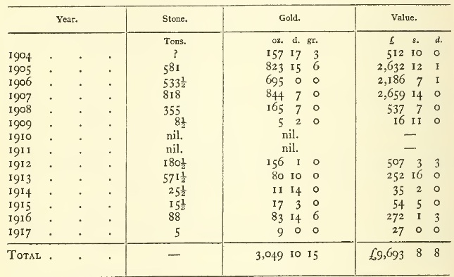
In a letter quoted in the Q.G.M. Journal of 15th March, 1905, Dickie gives some particulars of the early crushings on the field.
The Philp Goldfield has yielded a very small amount of alluvial gold. During the thirteen years of the field's existence, the statistics of the Mines Department only account for 58 oz. 13 dwt. This is, no doubt, an under-estimate, as from the geographical position of the place its alluvial gold would be sold for the most part in Cooktown, Ebagoolah or Coen.
Progressive estimates of the population of the field are given in the Annual Reports of the Department of Mines:-
| 1905 | . . . | 58 | 1912 | . . . | 3 | |
| 1906 | . . . | 25 | 1913 | . . . | 9 | |
| 1907 | . . . | 20 | 1914 | . . . | 8 | |
| 1908 | . . . | 13 | 1915 | . . . | 7 | |
| 1909 | . no return | 1916 | . . . | 10 | ||
| 1910 | . . . | 3 | 1917 | . . . | 2 | |
| 1911 | . . . | 3 | ||||
Writing on 14th August, 1905, [1] to the Under-Secretary for Mines, Dickie gives a further account of his 1901 trip, with observations added after the opening of the Philp Goldfield. He mentions that on this goldfield the reefs are all covered with sand and are only exposed in the beds of water-courses. He also remarks on the enormous dimensions attained by stringybark trees On the "desert" south of the field.
[1) Q.G.M. Journal, Vol. VI, p. 542.]
About the middle of 1907, Dickie reported the discovery of extensive deposits of antimony ore on the middle head branch of the Alice (read Philp) River, about 20 miles from Imooya. [2]
[2) Annual Report, Department of Mines, for 1907, p. 43.]
Writing from Palmerville under date 30th January, 1909, [3] Dickie describes how, in August, 1907, he and Campbell left the Mein Telegraph Station and followed the track to the Wolfram Camp (Bowden) on the Pascoe River.
[3) Q.G.M. Journal for March, 1909, p. 145.]
From Bowden, they went to the east side of the "main coast range" (Janet Range). (See MAP C.) It would be interesting to know whether they went through the range, past its northern side by the mouth of the Pascoe and the site of Kennedy's ill-fated camp, or past its southern side by my track of 1880. They then travelled so miles (say 35) south to Hays Creek. The question arises whether Dickie, like Dodd, took what is now called Dodd Creek for Hays Creek. They found gold "in all the large creeks —presumably tributaries of the Lockhart draining either the McIlwraith or the Macrossan Range. They also saw numerous reefs, but got no gold in them. At a place 40 (?) miles north of Hays Creek, by Dickie's reckoning, Campbell (who appears to have been there before) told Dickie that men had worked gold off and on for some years. At Hays (Dodd?) Creek, they found three parties working alluvial gold.
From Hays Creek, they visited some reefs 7 miles ENE., close to the coast (near Hays Hill?). One of the reefs had been worked in an open cut. They dollied stone from reefs and got good prospects of gold.
They then "crossed the range on to the western, or Gulf, watershed, and travelled north. All the big creeks on the western slope of the range were found to carry a little gold, and in two places they came across a few men working alluvial gold." Probably they came down Geikie or Attack Creek to the low country and then followed the Telegraph line NW. to Mein.
It was evidently from the impressions gained on this tour that the traverse by Dickie, Dick and Sheffield, described in another chapter, was initiated.
From a brief reference in the report of Warden J.F. Cherry, [1] it appears that Dickie was out prospecting in the Peninsula in 1909, but no account of this trip has come under my notice.
[1) Annual Report, Department of Mines, for 1900, p, 58.]
In 1910, Dickie, with Dick and Sheffield, made the extensive tour in the McIlwraith Range and Lockhart Valley which is the subject of another chapter.
From a letter written by James Dick on 26th May, 1913, I gathered that Dickie at that date was "out beyond Plutoville."
In February, 1914, he was working on the Annan Tinfield.
On 17th April, 1918, with James Hare, of Croydon, he set out from Richmond, on the Flinders River, with the intention of revisiting a mineral area which he had discovered some years previously, "300 miles North of Cooktown". [2] After having passed the Woolgar Goldfield, they got separated and lost, when out in different directions in search of water. (See MAPS P and R.) Dickie reached a Chinaman's hut on the Gilbert River after two days' wandering without food. Hare found his way to Gledswood Station at the head of the Norman.
[2) That would be about the head of the Jardine River. It is more likely that the two old prospectors were not "giving away" their objective.]
Dickie died in March, 1920.
{Page 713}
Dick's Narrative. Geographical Value of the Trip Consists chiefly in Identification of Places previously known. Start from Mein Telegraph Station. Batavia River. Fox's Old Station. Camp of William Partridge, A Prospector. Up Sefton Creek. Jack's Nob. Mount Carter. Across Divide of Peninsula. Reach Lockhart River at Giblet's Sandalwood Landing. Macrossan Range. Up Lockhart Valley. Dodd Creek breaches Macrossan Range. "Valley Hills" of Admiralty Chart. Gold on Upper Lockhart. Old Workings. Dodd Creek. A Sandalwood Depôt. The Golden Gate Reef. Men at Work. Story of Discovery by Dodd and Preston. Nisbet Reefs. Aboriginal Carriers. Down Lockhart Valley to Heming Heights. Up the Valley. Grassy, Untimbered Alluvial Plains. North-westward to and along Divide of Peninsula. Gold Prospects. Back to "Valley Hills" Camp. Two Blacks join Party. Gold in Reefs. Gold on Surprise Creek. Appel's Pinnacles. Gold Prospects. Dense Scrub. Disposal of Aboriginal Dead. Down Lockhart Valley. To Summit of McIlwraith Range. Sandalwood Packer met. Ascent of Mount Carter. Batavia River. Bairdsville, The Scene of William Baird's Discovery of Gold and Subsequent Murder. Chock-a-Block and Plutoville Diggings. Back to Mein. Mayer and Claussen's Reef On Horse Creek. Visits to Ebagoolah and Violetville. Dickie's Report. Biographical Notes on James Dick and List of his Writings.
THE McILWRAITH RANGE, named, traversed and sketched by me in 1879-80, is still only known to geography through (1) my sketch-map (which appears to have been seriously misinterpreted by the Survey Office) and (2) the wheel-and-compass surveys of Mr. J.T. Embley, Licensed Surveyor. (See MAP C.) The latter in 1884-5 defined the position and course of Sefton Creek and the head of the Batavia River and of Geikie Creek, one of the heads of the Archer River. Between the Batavia River and Geikie Creek, approximately on the meridian of 143° 16' E. long., a north-and-south line was run from 13° 8' to 13° 22' S. ht., to connect the river with the creek, and a few miles to the west of this line, some further lines were drawn in connection with the survey of "Bald Hill" and "Bald Hill, No. 1" pastoral holdings.
My original sketch-map was not published with the official report of which it was an essential part, and has apparently been lost between the various departments through which it passed. I have, however, been able to reconstruct it, from my field notebooks, and this new compilation, as given herewith, in the region covered by the McIlwraith Range, differs materially from the current issue of the official map, Sheet 20C, although it in no instance conflicts with Mr. Embley's surveyed lines.
In 1910, John Dickie, James Dick and Arthur H. Sheffield made a tour through the McIlwraith to the Macrossan Range, with some Government assistance. Dickie, the leader, so far as I am aware, made no report except the few lines paraphrased at the end of this chapter. The history of the expedition was written by Dick in a report dated Cooktown, 12th November, 1910. An abstract of this report was published in the Queensland Government Mining Journal of 15th December, and was accompanied by a sketch-map on the scale of 8 miles to an inch, drawn at the Geological Survey Office, Brisbane. Mr. Dick also read a paper on the subject before the Royal Geographical Society of Australasia, Queensland Branch, on 1st May, 1911.
Numerous difficulties, arising out of my attempt to follow the expedition on the map, led to a correspondence with Mr. Dick, and it was seen that the printed abstract must have omitted some portions of the narrative which were of importance from a geographical point of view, and that the writer's meaning, in some cases, had not been fully grasped by the editor. Mr. Dick, to whose letters of 19th February, 1911, and 5th and 12th May, 1912, I am particularly indebted, was kind enough to send me the 4-mile map which had accompanied his report, and which had been returned to him. Through the courtesy of Mr. Henry Marshall, Under-Secretary for Mines, I have been able to peruse the manuscript of Mr. Dick's report.
Finally, all the above sources of information having been exhausted, I borrowed the diary which Mr. Dick kept while in the field. From the material which had thus accumulated in my hands, I have been able to add much useful information to the map.
The party left Cooktown on 8th June , 1910. From the railway terminus at the Laura they followed either the Telegraph line or roads. Passing Yarraden and Ebagoolah (Hamilton Goldfield) (MAP F) and the township of Coen (MAP C), they reached Mein Telegraph Station On 27th June.
Leaving Mein on 1st July, the course taken was E. by N., first crossing a portion of the Geikie sandstone tableland. Near the head of Clayhole Creek, a tributary of the Batavia River, the party saw, about 6 miles from Mein, the remains of a native Police Camp, which must have dated from about 1887, as it was erected for the protection of the Telegraph Construction party. Frog Hollow and Fox's Creek , tributaries of the Batavia River, were next crossed, and the Batavia River itself was reached (Camp 15) about 20 miles from Mein. Fox's Old Station was on Frog Hollow.
The Batavia was apparently struck only a short distance above the rich alluvial goldfield of Plutoville (which was to be discovered in October of the same year). Above the crossing of the river, a bark hut was seen, the temporary dwelling of William Partridge, a prospector who, it is mentioned, had, "with others", a few months previously, got 30 ounces of gold in the Batavia. [1]
[1) This casual reference acquires an additional interest in the light of a statement made by M. W. Shanahan in "With the Cape York Prospecting Party, being an Account of a Trip from Cape York to the Carron Range, with various Peninsular Sidelights", in Queenslander of 19th September, 1896. The statement is that Partridge is "now a semi-millionaire" and making a figure "in London Society".]
In about 2 miles up the river to the east, the infall of Sefton Creek was seen on the right, or northern, bank. The Sefton was followed up to the NE. for about 8 miles, where the party must have crossed my track (between Camps 30 and 31) of 26th January, 1880.
The travellers then followed Sefton Creek to the east for about 15 miles until the creek was obviously near its head. The creek was prospected all the way, but only "fine colours" of gold were obtained. Near its head they "came in sight of Jack's Nob and Mount Carter", peaks which had been named and located by Mr. Embley. Dick's description of the view from Mount Carter (which he ascended on his return journey) proves at least that Mount Carter and my "View Hill" of 20th January, 1880, are distinct.
gold ("colours") was first met with on 5th July, between Camps 17 and 18, in a creek falling into the Sefton. "Fine colours" were obtained in the Sefton itself next day.
Near the head of the Sefton, Dick observed an old tree branded W.L., which was taken to mark a visit by William Lakeland, prior to his discovery of the Rocky Goldfield in 1893. (Lakeland assisted Embley in his surveys of 1884-5.)
Owing to the steepness of the rocky slopes and the density of the scrub, Dickie and his party experienced insurmountable difficulty in trying to cross the backbone of the McIlwraith Range by the head of the Sefton, which had turned to the north-west. They were turned back again and again, had to hew their way through the scrub, and nearly lost their horses, but finally got away to the south-east and crossed the range on 14th July. On the same day they lighted on a fresh horse-track, which they believed to have been made by Partridge. They then dropped down into the valley of the Lockhart River by a track which had been cut by sandalwood-getters, and which led them, through a long scrub, over steep and rugged ground, and lastly "over flat pastoral country and numerous water-courses" north-eastward to a landing, on tidal waters, on the left bank of the river, where there was an old camp and some cases branded "H. Giblet". Here the party camped on the 18th July (Camp 29). But for the happy accident of striking this track, says Dick, it might have taken some weeks to get down, and some of the horses might have been lost. Up to the moment when the salt water was sighted, the leader, according to Dick, was under the impression that he was still on the headwaters of the Batavia River.
In descending the range, the party believed that they had identified, and to some extent followed, the water-course which I had named Greyhound Creek On 18th January, 1880. The creek seen by them was probably at least of equal importance, but must have been about 16 miles north of Greyhound Creek.
It will be remembered that I first saw and named the Lockhart River On 14th January, 1880. As early as 1872, however, Captain (afterwards Admiral) Moresby had attempted, with the gig of H.M.S. "Basilisk", to penetrate beyond the channels among the mangrove swamps at the south end of Lloyd Bay, and had come, reluctantly, to the conclusion that "there was no river," adding "the drainage of a hill 6 or 7 miles inland had created a swamp of many miles in extent, covered by mangroves and intersected by these salt-water creeks, and that was all." [1]
[1) Discoveries and Surveys in New Guinea and the D'Entrecasteaux Islands. A Cruise in Polynesia and Visits to the Pearl-Shelling Stations in Torres Straits, of H.M.S. "Basilisk". By Captain John Moresby, R.N. London, John Murray, 1876, p. 125.]
Mr. J.T. Embley informs me, in a letter dated 13th June, 1915, that in 1913 he went up the river from its mouth about 8 miles, which was as far as a boat could go. He describes the river as being, at its mouth and for some distance up, "a network of channels, with islands, making it very difficult for a stranger to navigate the correct channel." A "Town Reserve", of 2,660 acres, covering the mouth of the river, was gazetted in 1889. Apparently it has not been surveyed, and Embley's description suggests that it must consist mainly of salt-water channels and mangrove swamps.
The whole of the Macrossan Range, SO named by me on 8th January, 1880, and extending from 12° 55' to 13° 38' S., has since been sketched by marine surveyors, who have taken the liberty of renaming all but an insignificant portion of it. According to the legend on the Admiralty Chart, "Claremont Pt. to C. Direction", this was done by the Officers of H.M.S. Surveying Ship "Dart" in 1896-7. From north to south, the names, which are copied in the Lands Department's 4-mile Map of 1908, are as follows:—
12° 55' to 13° S.—Heming Range, Heming Peak, North Peak, Cleveland Hill.
13° to 13° 5'.—High Range, High Peak.
13° 5' to 13° 10'.—Chester Range, Chester Peak.
13° 10' to 13° 12' 30".—Valley Hills, Meston Range.
13° 12' 30" to 13° 17' 30".—Eve Peak, Adam Range.
13° 17' 30" to 33° 22'.—Howard Range, Hangklip Peak, Table Mt., Horn Hill.
13° 22' to 13° 29'.—The name "Macrossan Range", originally given to the whole range, is restricted to this portion, and Cone and Plant Peaks appear at its northern and southern extremities.
13° 29' to 13° 38'.—Embley Range, Round Mt., Hobbs Hill, etc.
The depiction of the whole Macrossan Range, as it appears on the chart, is an admirable piece of sketching, and the various peaks, ranges and mounts have, no doubt, been located by triangulation. If these points are correctly located (which I do not question), they are to be welcomed as useful additions to the map. There is, however, no justification for paring down the Macrossan Range, which had appeared as such on official land and geological maps up to the date of the Admiralty survey. For this reason, the original name of" Macrossan" is restored to the whole of the range on the map accompanying this volume, and the other so-called "ranges" are reduced to the status of "heights".
The range must obviously have been sketched by the marine surveyors from the east, and therefore even its most conspicuous eminences would be hard to identify by observers approaching, like Dickie, Dick and Sheffield, from the west.
On 19th July, Dickie's party travelled south for a distance which Dick estimated at 10 miles—probably an over-estimate, crossing nine creeks running eastward to the Lockhart (Camp 30). Next day they covered an (over-?) estimated distance of 8 miles, presumably south, and camped (Camp 31) with Ned James, who, with three black boys and twenty-five horses, were packing sandalwood for H. Giblet.
On 21st July, 8 (estimated) miles to the south were accomplished through scrubby country, with the untimbered plains seen by me in 1880 on the east (Camp 32). This camp was on what Dick called "Dr. Jack Creek".
On 22nd July, the McIlwraith Range was skirted for an estimated distance of 6 miles, through scrub and long grass, very trying, says Dick, to the horses and to the temper of the men.
Camp 33 was probably on Surprise Creek.
Small progress was made on 23rd July, owing to difficulties with scrub and long grass. Camp 34 was near the McIlwraith Range.
On 25th July, the previous day (Sunday) having been employed in burning grass, etc., a progress of, say, 4 miles was made eastward to the bank of the Lockhart River (Camp 35), Cherry Creek having been crossed near Camp 34. Dick's sketch-map shows "Dr. Jack", "Surprise" and "Cherry Creeks" running north-easterly from the McIlwraith Range into the Lockhart River. They can probably be identified from his description, but, considering the indefiniteness of his mileage, they had better wait for a survey before being put on the map.
On 26th July, the party crossed from the left to the right bank of the Lockhart, and the Leader struck out to the east, saying that he was making for the McIlwraith Range. This is wellnigh incredible, and can only be explained on the supposition that he had previously mistaken the Macrossan Range for the McIlwraith. Not long after they had started to go east, the party came in sight of the sea, which must have been visible through the gap made by Dodd Creek in the Macrossan Range between Meston and Adam Heights. Admitting his mistake, Dickie turned back and headed to the west. Presently the party found themselves on a well-beaten track, which they supposed to go from Hays Creek to Tin (Hull) Creek. The track was followed till it recrossed to the left bank of the Lockhart, where Camp 36 was made.
The creek (Dodd Creek) which, in this locality, breaches the Macrossan Range, was erroneously taken for Hays Creek, which is further south. Dick says that Dodd believed this creek to be Hays Creek.
On the 27th, the camp was moved 2 miles east of the Lockhart, to some "bald" hills seen on the previous day (Camp 37). The following passage occurs in Dick's diary of this date:—
"In the valley of Hills is a perfect maze of ravines, gullies, creeks and scrubs, One could easily get bushed . . . We were camped near the track from the Sandalwood Landing to Tin Creek."
This, the first mention of the "Valley of Hills", leads me to think that Dick believed he had identified Dodd Creek (which he took for Hays Creek) with the "Valley Hills" vaguely indicated on the Admiralty Chart and the Lands Department's 4-mile Map. On subsequent dates, this Camp 37 is referred to as the "Valley of Hills", and sometimes as the "Valley of Green Hills" camp.
The Admiralty Chart bears, in 10° 2' S. lat., the words "Valley Hills", which refer either to two hills, of 900 and 879 feet, on the crest of the Macrossan Range, or to hills in a distant valley seen from the ocean through an opening between the two peaks referred to—in other words, to some portion of the McIlwraith Range. Dick's "Valley of Hills" is evidently not the "Valley Hills" of the chart.
From Camp 37 as a base, Dickie and Dick prospected the head of the Lockhart till 2nd August, tracing gold, in the form of "fine colours", for the greater part of the way. The best place gave three grains of scaly gold to three dishes of dirt. In one gully they found a sluice-box, a certain proof that others had been ahead of them and actually working gold, and in two other places they found old workings. In the last of these places their tests led them to conclude that the ground was poor, but a "good fossicker might make 3 dwt. a day for a few months."
Starting from Camp 37 on 3rd August, Dick and Sheffield followed a path which led them down the valley of Dodd Creek to the coast, where they found a long sandy beach and a large camp, with yards and huts, evidently a depôt for sandalwood. A track led northward from the depôt. They returned to Camp 37 after dark.
On 4th August, Dick and Sheffield rode out to see if the track from the sandalwood depot on the coast led to Hays Creek. The "good blazed track", however, led them to the NW. until they were satisfied that they were on western waters, among the heads of Falloch, Geikie or Hull Creek, as they imagined, but more probably on the head-waters of the Batavia. In many places, old yards and camps were observed, showing that this part of the range was already well known to the sandalwood men. After a long day's ride, the travellers returned to Camp 37 in the dark.
On 5th August, Dick and Sheffield left the "Green Hills camp (37) in search of Hays Creek. In a valley between the Lockhart River and the Macrossan Range they struck a creek which was new to them, as, after coming from the south, parallel with the Lockhart (which continues to run north till it falls into Lloyd Bay), it turns east and breaches the Macrossan Range. They concluded that the creek was Hays Creek. Shortly afterwards they struck a track running southward up the valley—evidently the pack-track leading from Dodd and Preston's camp to the landing visited on 3rd August. In about 6 miles to the south, the track brought them to Dodd and Preston's camp at their Golden Gate Reef. The diary states that "Dodd and Preston's mine is situated on the divide of Hays and Nisbet waters." As, however, Dick took Dodd for Hays Creek, the sentence should read "on the divide of Dodd and Hays Creeks." The night was spent at the mining camp, and the reef was visited. There were at the time only three men at work on the mine, but two visitors were also met; one was Anderson, the storekeeper from Ebagoolah, and in the other Dick recognised a shipwrecked mariner, named Coleman, whom he had seen three years before at Thursday Island.
On 6th August, Dick and Sheffield returned to Camp 37, by the spur dividing Dodd Creek and the head of the Lockhart, guided by a black boy in the employ of Anderson and Coleman. The spur showed the outcrops of numerous quartz reefs.
Some interesting particulars of the opening of the Golden Gate Reef are given by Dick in his Geographical Society paper and his diary. It appears that Dodd and Preston came on foot from the Rocky Goldfield, carrying their tools and provisions on their backs, often hacking their way through the scrub. They had to contend with two wet seasons before getting any return for their labour. They transported half a ton of machinery 6 miles from the coast—and then it proved useless. They had to hire horses from 100 miles away to pack their first stone to the coast, charter a boat to carry it to Cooktown, ship the stone from Cooktown to Townsville and transport it by rail to Charters Towers.
According to the Annual Report of the Department of Mines for 1910, the Golden Gate Reef was formally "taken up" On 4th October, 1909. Its second consignment of stone (which Dickie's party met in transit), consisting of 36½ tons, yielded 274.8 ounces of gold, valued at £846, when treated at Charters Towers. The first trial crushing (2.2 tons) had given 23 ounces, valued at £79 7s.
The Nisbet Reefs, discovered in 1896 [1] (presumably by prospectors following the track marked by Baird and Marrett), are apparently near the head of the Nisbet River, south-east of my Camp 25. Their port was at the mouth of the Chester River, from which passengers and goods went by boat to meet the mail steamers at Claremont Island Lightship. By this time there was a road from the Coen to the mouth of the Chester, and aboriginal carriers were transporting goods between the Chester and the Rocky River. Warden F.J. Cherry reported that in 1896 a trial crushing of 85 tons had yielded 283 ounces of gold.
[1) Ann. Rep., Dept. of Mines, for 1896, p. 46.]
On 8th August, Dickie and Dick set out on an excursion from Camp 37, down the Lockhart Valley, following the west side of the Macrossan Range, and burning the grass as they went along. Passing Meston and Chester Heights, they camped first under the north of the "High Peak Range" of the Admiralty Chart. [2]
[2) In a letter dated 13th July, 1915, Mr. J. T. Embley agrees with me that it would be difficult to identify from the western side the "peaks" of the chart, which were surveyed from the east, but says that "High Peak" is a good landmark: "It towers above all the other points. Possibly from the eastern side it is merely a high peak on the range, but has its immediate base fronting on the first country."]
A sandalwood track was seen going north from Giblet's landing on the Lockhart River (i.e., Camp 29).
On 9th August, the two travellers continued to ride north till they were in sight of the northern end of Heming Heights, when they turned back. The long and matted grass was set on fire to facilitate the return journey. The fire at one time proved a serious menace, and the travellers were obliged to cross the river hastily to avoid it; whereupon they camped for the night.
On 10th August, recrossing to the right bank of the Lockhart, some miles of the return journey proved easy travelling over the burnt ground, but further to the south there was heavy grass, still unburnt, in places. The travellers passed over "beautiful, naturally drained, alluvial flats, 5 or 6 miles wide and 10 to 15 miles long, with a bit of 'devil-devil.' . . . It ought to be great sugar land." They reached Camp 37 at night.
The object of this excursion was to see some country which Dick had been informed at Dodd's camp was considered by Bowden to be" likely "for gold. It would appear, therefore, that William Bowden, the well-known prospector, had already visited this district.
On 12th August, the whole party left Camp 37, which had been their headquarters since 27th July. They appear to have travelled north-north-west, as they arrived in an hour at the first of the yards which Dick and Sheffield had visited on 4th August. They travelled altogether an estimated distance of 10 miles, having crossed the divide to western waters, and camped at noon on a large creek which they conjectured might be Hull Creek, but which may have been one of the heads of the Batavia River (Camp 39).
In 10 miles of travelling W., N., S. and E., on 15th August, the party kept nearly on the watershed of the Peninsula, finally camping on the eastern, or Lockhart, fall (Camp 40). The grass was long, and too wet to burn, and there was not a gully which could be prospected. Dick remarks on the absence of a "range on the watershed, and his ideas as to his position were vague. Early in the day he believed himself to be on the west side of Ben Lomond. He was, in fact, trying to reconcile his experiences with the imperfect map (the 4-mile Lands Map) in his hands (on which Attack, Geikie, Falloch and Hull Creeks are misplaced and Ben Lomond is not shown).
On 16th August, after a short run to the north-east, a thick scrub was met with, into which gullies ran eastward, to join the Lockhart. The edge of the scrub was followed to the south, and the party found themselves, after an estimated course of 8 miles, back on their track of 12th August (Camp 41). "Fine colours" of gold were obtained from gullies near the camp on the 16th and 17th.
On 18th August, Dick and Sheffield went out prospecting towards the McIlwraith Range, i.e., towards the divide, crossing deep gullies, thick scrub and long grass. In several gullies they got "colours" of gold. Camped at nightfall in a grassy pocket (Camp 42). This camp is marked in the diary "Surprise Creek Camp".
In the morning of 19th August, Dick and Sheffield prospected a gully below the camp and got gold in several dishes, some of it in "coarse colours".
While the men were at work prospecting, the dogs sounded an alarm, and two black boys were discovered up a tree. The blacks were unarmed and explained in English that they had only retired from fear of the dogs. On descending, they agreed to join the party.
The creek on which Camp 42 was pitched appears to be considerably (say 8 miles) north of the position assigned to "Surprise Creek" by the "Sketch-map prepared at the Geological Survey Office."
On 20th August, Dick, Sheffield and the two boys returned to Camp 41, where Dickie had been left. The latter had been busy prospecting for auriferous reefs. The following day the party returned to Camp 37 ("Valley of Hills Camp").
Accompanied by the two boys, Dick and Sheffield left Camp 37 on 22nd August, camping the same night on Albert Creek (Camp 43), and on 23rd On Arthur Creek (Camp 44). I am unable to locate these creeks. Albert Creek, which was in a scrub, gave gold which just fell short of being payable. Dick reckoned that "a good hand might make 2 dwt. a day sluicing." Arthur Creek was reached by crossing Surprise Creek, and gave about 3 grains of gold to 5 dishes: "a man might make 2 dwt. a day."
On 24th August, led by the boys, Dick and Sheffield made for "the range", and ascended a very steep spur and camped, apparently still in the drainage area of Albert Creek.
Attava Creek (which I am unable to locate) was prospected on 25th August, and only gave "colours" of gold. The country was scrubby, but a sandalwood track was found.
On 26th August, via Camps 43 and 44, the party returned to the "Valley of Hills Camp" (No. 37).
The flour at this main camp was now exhausted, and the beef was nearly finished. The black boys, however, supplied the table, to some extent, with scrub hens and their eggs and a cassowary chicken. Dickie rode to Dodd and Preston's camp, returning on 28th August with flour. Sheffield and a black boy started on the 29th for the Mein and returned on 8th September with a load of rations which had been left at the Telegraph station. Dickie was out prospecting for reefs and brought to the camp several specimens Of quartz showing gold.
After Sheffield's return, Dickie and Dick rode out to "some gullies north of Hays Creek" (i.e., north of Dodd Creek), "under Adam Range" (Heights). "Got colours in over half a dozen gullies and in the reefs, but nothing payable." They also got a "half-grain prospect" in Hays (i.e., Dodd) Creek.
On 13th September, Dick and Sheffield set out, accompanied by the two black boys. Crossing ridges and deep gullies and cutting through scrubs, they came on Surprise Creek about 2 miles higher than where they had surprised the boys on 19th August (which was near Camp 42). Here, again, they got "colours" of gold, and they saw a track which the boys informed them had been cut some years ago by Police-Sergeant Whelan, who failed to get through, and had to return. The scrub here was much troubled with the thorny "lawyer vine" and had many bamboos.
Up to 17th September, various heads of Surprise Creek were prospected. Several places-were found where the prospects of gold were almost payable, or might have been payable under more favourable conditions. Cutting scrub, burning grass and the care of the horses—which had to be tied up in the day and taken back to grass in the moonlight—took up a good deal of the time. The reconnoitring party returned to the "Valley of Hills Camp" (No. 37) On the 17th.
Dickie went to Dodd's Camp on the 18th and returned on the 19th with 50 lb. of flour. On the 20th, the party moved out to Surprise Creek (Camp 50). Before they left their camp in the morning, a man arrived from the Coen and also two men from Granite (Hull) Creek on their way to Dodd's Camp. [1]
[1) The documents at my disposal do not enable me to locate Camps 38 to 49, inclusive.]
On 21st September, the party passed Appel's Pinnacles, and crossing Pinnacle Creek, camped in a grassy pocket (Camp 51). The afternoon was spent in cutting scrub, burning grass and prospecting. A quartz outcrop in a scrub showed galena and pyrites and also gave "colours" of gold. The "nest" of a scrub turkey —a mound of earth and vegetable mould in which a colony of birds leave their eggs to be hatched by the fermentation of the vegetable matter—measured 120 feet in circumference and rose to a height of 12 to 15 feet.
Appel's Pinnacles, which Dick regarded as the eastern portal of the McIlwraith Range, are five in number, rising to a height of over 1,000 feet above their surroundings. They were named in honour of the Minister for Mines. In Pinnacle Creek, which comes from the west and falls into Surprise Creek, "fine colours" of gold were obtained on 22nd September. The party tried to reach a range to the north, which had been seen from the Pinnacles, but were turned back by the density of the scrub.
From Camp 51, an unsuccessful attempt was made to penetrate the scrub to NE. on 23rd September. Two tributaries of Pinnacle Creek were named Humbug and Puzzle Creeks.
In showery weather, the party left Camp 51 on 24th September and struck north. After traversing good country, with grass two months old, a creek "as large as the Lockhart" was met with at the same place where it had been crossed on the outward journey (about 19th July). It came out of the scrub and took a NNE. Course. Dick called it "Dr. Jack Creek". The camp at the crossing would be numbered 52.
A very careful study of the diary leads me to place the group of creeks shown on Dick's map, including Cherry, Surprise and Jack Creeks—in all of which gold was met With—north of Greyhound Creek, and south of the creek improperly called by that name in the sketch-map drawn at the Geological Survey Office and the 1915 issue of the 4-mile map.
From Camp 52 to Camp 53, northward, "hugging the range all the way, but rather too close", there was difficult country, but a distance estimated by Dick at 11 miles was covered. Camp 53 (26th September) was near the junction of two boggy and scrubby creeks, tributaries of the Lockhart River.
In this day's diary, Dick records an instance of the aboriginal method of disposal of the dead. The body reposed on the limbs of a tree and beside it were some spears and wimmeras.
On 27th September, continuing the journey to the north near the range, but keeping to the low country, Camp 54 was pitched on the site of Camp 31 of the outward trip. Good grass for the horses had already replaced the mat of old grass which had been burned. Some large "buck" reefs of quartz were observed.
The northward course was pursued for four hours on 28th September, between the left bank of the Lockhart River and the McIlwraith Range. Some of the blady grass which had escaped the fires was 18 feet high.
On 29th September, the party finally left the Lockhart Valley and the foot of the McIlwraith Range was reached in about 21 miles. The ascent to the summit must have been easy, as it was accomplished in an hour and a half. Mount Carter was sighted, and Camp 56 was pitched near the summit of the range.
Near the camp, Ned James was again met with, engaged in packing sandalwood with twenty-five horses. In the course of conversation, he informed the prospectors that William Lakeland had been out in this neighbourhood and had got coarse gold.
Dickie and Dick prospected a creek (a head of the Batavia— or Sefton Creek?) the following day, but got no gold. They then Climbed Mount Carter, which was of granite, and which Dick estimated at 2,000 feet high. From the summit, a creek was seen running NE. into Lloyd Bay, the Sefton Valley lay to the south and in the north the Pascoe valley was seen falling to the west. Between the camp and the mountain was a blazed track leading in the direction of Lloyd Bay.
On 1st October, the party left Camp 56, and, keeping Mount Carter on the right, coursed SE. and SW., and camped (Camp 57) on the Batavia River. A quartz outcrop, which had been prospected before, was seen on the way. The party remained in Camp 57 till 4th October.
On the 2nd, the ubiquitous Ned James again turned up, with a party of blacks. The boys provided the explorers with an emu, a turkey and a hen, which they had shot.
On 4th October, the party moved on to WSW. and after passing three sandalwood camps, reached Baird's Pinnacles, where they camped (Camp 58). The pinnacles are weathered towers of sandstone on the north-eastern corner of the Geikie Range. Below them, to the north, lay the Bairdsville mining centre and the lonely grave Of its discoverer, William Baird (1892), who was killed by the blacks in 1896. Chock-a-Block, another gold-mining centre, was visible to the north between the Batavia and Pascoe Rivers. I am indebted to Dick's sketch-map for the approximate positions of Bairdsville, Plutoville and Chock-a-Block. The two latter have not yet appeared on any map, so far as I am aware, while the latter is incorrectly placed on the sketch-map drawn to illustrate Dick's report when it appeared in the Government Mining Journal.
A few months before the Dickie party's visit, William Partridge and others had Won 30 ounces of gold from the Batavia River, and gullies which yielded payable gold had been worked by Gleeson, Ward, Weiss and Edward Downs. Downs had got 60 ounces at Chock-a-Block.
A week was spent by the Dickie party prospecting around Bairdsville, but nothing very promising was met with. One of Giblet's boys turned up at the camp on 7th October, on his way to the Ducie River, with horses. This boy had information to give respecting the Lockhart, which might have been of some service had it been given in time.
By this time, the McIlwraith Range appears to have been thoroughly known to sandalwood getters, who had marked many tracks across it, between Giblet's landing on the Lockhart and the Mein Telegraph Station. Many miners and prospectors also had tracks leading out to the east of Mein in various directions, including one to Dodd's Golden Gate camp.
It is stated in the Annual Report of the Department of Mines for 1892 that after William Baird had reported the discovery of payable gold on Retreat Creek, Batavia River (Bairdsville), in October of that year, he went, accompanied by Sub-Inspector Marrett, to the mouth of Hays Creek, marking a track. I assume that Baird and Marrett correctly identified Hays Creek and did not confuse it with Dodd Creek, as Dodd and Preston and subsequent observers did.
The Dickie party left Bairdsville On 12th, reached MEIN On 13th and left for Cooktown on 15th October. Following the Telegraph line to the south-east, they camped 25 miles from Mein, where they unsuccessfully prospected some "likely" country. Dick and Sheffield crossed the Geikie Tableland (my track of 20th December, 1879, to Camp 13) on 17th October and visited Mayer And Claussen's Reef On Horse Creek, about 6 miles WNW. of the camp on the Telegraph line where Dickie remained. Mayer and Claussen were busy erecting a 6-head battery. On the return of Dick and Sheffield to the camp in the afternoon, they found a note from Dickie, who had tired of waiting, and had gone on. Dickie sent his report from the Coen. Dick and Sheffield boarded the train at the Laura terminus and arrived at Cooktown on 1st November, 1910.
A few notes may be culled from the diary to show the condition of the mining centres south of the Coen.
Ebagoolah (Hamilton Goldfield).—The Ada Battery was situated between Slaughteryard Creek and Ebagoolah. The owner, J. Thompson, was largely interested in the Caledonia and Hamilton King mines.
Violetville (Hamilton Goldfield).—The camp, or township, is situated on the principal head of the Lukin (so called by Mulligan, although previously named the Holroyd by Jardine). The "Big Reef", on Gold Mount, is described by Dick as from 5 to 25 feet wide and fully 500 feet in length, supposed to be worth half an ounce of gold per ton, the gold being valued at £3 per ounce. The "Lukin" Battery was on water 3 miles from the mine and was owned by D. Wilson, who had also a mine named the Haikai.
An area of 965 square miles was set aside in 1908 as an Aboriginal Reserve. Commencing at Cape Sidmouth, the boundary-line goes west for 33 miles, north to Mount Tozer in the Janet Range, and cast to Cape Griffith, thus enclosing the greater part of the Macrossan Range, a large part of the McIlwraith Range, and half of the Janet Range, besides the whole of the Lockhart valley and the head of the Nisbet valley. Considerable portions of this reserve are already occupied by miners, who, there is no doubt, will require more of it as the industrial occupation of the country progresses.
Mr. John Dickie, in a short report supplied to the Mines Department and dated Coen, 20th October (1910), states that the country prospected was from the head of the Hays Creek 20 miles northward. The country he describes as very broken, with creeks and gullies everywhere, all of them containing a little gold. The golden belt is 8 miles in width. There were reefs in places right through, and nearly all that were tried contained gold. The best reefs were found within 5 miles of the camp of Dodd and Preston, on Hays Creek waters. Little sinking was done on any of the reefs tested, because a payable reef would be of no use to anyone in this country without a battery. The reefs were all very "buck"-looking on the surface, but when sunk on to a short depth they were all found to be heavily mineralised. Mr. Dickie considers there is no doubt that remunerative reefs can be found throughout this country. The party, he says, discovered no payable alluvial, but he thinks such will be found north of the belt, 20 miles by 8 miles, which was prospected on this occasion. There was a belt of scrub on the dividing range, 7 miles long by 8 miles wide, which was not prospected, but all the creeks and gullies running out of this scrub on either side of the range carry a little gold. The formation throughout the 20-mile belt examined, Mr. Dickie describes as granite with schist in places, and a little diorite all through. He mentions that on the map which he had, only two heads of the Lockhart are delineated, whereas there are about twelve large branches and some thirty small creeks all running into this river. The distance from the northern end of the 20-mile belt of country examined to the workings on the Rocky Goldfield is 50 miles as the crow flies, and a little gold is to be found in all the creeks and gullies right through. The distance to the Pascoe River, where Mr. Dickie stopped prospecting last year, is 55 miles, and over this country, too, gold is to be found in places. [Queensland Government Mining Journal, 15th December, 1910, p. 603.]
This chapter may appropriately close with a tribute to the memory of James Dick.
Dick came from Victoria to Cooktown shortly after the outbreak of the Palmer Goldfield. In 1876 he was at work in the diggings of Sandy Creek,when his health failed and he returned to Cooktown. Here he found employment in the store of the late John Walsh. Later on he started the Little Wonder Store and selected land on Carroll's Creek. When his family grew old enough to run the selection, he himself followed his natural bent and went prospecting on every opportunity. He claimed to have "worked on or visited every field in the Cook district." A painstaking habit of recording every incident touching the development of the Cape York Peninsula made him eventually a never-failing authority on historical questions.
For some years he was a member of the Municipal Council of Cooktown and in 1906 he (unsuccessfully) contested a seat in Parliament. Patriotic and public-spirited, he devoted himself without stint to the best interests of the district in which he had cast his lot. He was a voluminous writer, but unfortunately many of his articles were contributed to journals which had only a fleeting existence and are inaccessible and practically lost.
A list—which I am aware is far from complete—of articles and pamphlets written by him is given in the appendix. One of them practically forms the text of this chapter.
Another pamphlet, "A Geological and Prospecting Expedition which filled up many Blank Spaces", etc., was, in a sense, responsible for the present volume. In its serial form, as it appeared in the Port Douglas Record, he sent it to me, with an intimation that he intended to reissue it in a book or pamphlet. Its perusal brought home to me very acutely what I had long been conscious of, viz., the injury which had been done by the publication of my report on the expedition referred to without the accompanying map, which was an essential part of it. If Dick, a friendly critic and a competent observer, and familiar with the district, could fall into the mistakes which he did, how could the general reading public be expected to understand? I begged for and secured a delay in the issue of the pamphlet until I should have time to correct it in so far as statements of fact were concerned.
It so happened that when Dick's communication reached me I was already engaged in the preparation of an annotated reissue of my original official report (by that time long out of print), with the map which should have accompanied it on its publication. This task having been accomplished in course of time, I felt that the work was incomplete without a review of the work of previous explorers by land. Next it seemed that the story should be continued and that the history of the region should be followed down to the present time. It had already become evident that the progress of land exploration was intimately connected with maritime discoveries reaching back to the three-centuries-old dawn of authentic history; and these also had to be brought under review. While I was engaged on this task I was in almost constant correspondence with Dick, who responded with ready courtesy to my demands on his time, and who, out of his intimate knowledge of actors and details, solved many of my difficulties. I first met him in Cooktown in 1879, when I was struck by his public spirit and insight. The only other opportunity of personal contact with him which I enjoyed was when I spent a week in his company on "The Conglomerate" (Palmer Goldfield) in 1896. He died in May, 1916. The portrait herewith dates, I believe, from 1910.
"Prospecting in the Cape York Peninsula: Tour of Mr. Dickie and Party", by James Dick (dated Cooktown, 12th November, 1910). Queensland Government Mining Journal, 15th December, 1910, p. 600.
"From the Mein Telegraph Station NE. to Lloyd's Bay and up the Lockhart River to its Head", by James Dick (read 31st May, 1911). Queensland Geographical Journal, New Series, 1910-12, p. 38.
Mineral Resources ol the Cook District: A Retrospect." Port Douglas, Record Printing Co., 1910.
"Mining in the Peninsula", article in Cairns Post, 23rd August, 1911.
"The Cape York Peninsula: Its Resources and Possibilities", Cairns Post, 23rd August, 1911, et seq.
"Early Reminiscences." Port Douglas Record, 1913.
The Great White Line (a Plea for a Railway following the Cape York Telegraph Line). Port Douglas, Record Office, 1913 (dated October, 1912).
"Explorers, Pioneers and Prospectors through the Cape York Peninsula." Port Douglas Record, 2nd September, 1913.
"Out in the Jack Country" [Queensland 4-mile Map, Sheet 20.A]. Port Douglas Record, 21st October, 1913.
A Geological and Prospecting Expedition which filled up many Blank Spaces on the Map. Mr. R. L. Jack, Geologist, and Mr. J. Crosbie, Leader Prospector. Port Douglas, Record Office, 1913.
{Page 729}
Prospecting in Peninsula since 1876. Took part in Discovery of Bowden Mineral Field. To Bairdsville, 1892. Discovered Alluvial Gold at Rocky River, 1893. Small Rush. Alluvial Gold exhausted. Auriferous Reefs discovered. Rocky Goldfield proclaimed, 1897. Water-power Mill, 1896-1910. Hamilton and Claudie Rivers.
I AM unable to discover a scrap of writing by William Lakeland himself, although it is well known that he has been one of the earliest and most assiduous prospectors of the Cape York Peninsula. His best-known achievement is the discovery of the Rocky Goldfield.
Explorations in the Peninsula by Lakeland in 1876 are incidentally referred to by James Dick in his pamphlet entitled A Geological and Prospecting Expedition which filled many Blank Spaces (1913), but no localities or results are mentioned. Lakeland was one of the party (the others being William Bowden and John Dickie) who located wolfram on the Bowden Mineral Field between the Pascoe River and Canoe Creek, about 1887. Shortly thereafter he left for Croydon. He was known to have been prospecting in the Peninsula before he discovered the Rocky Goldfield, and an old tree bearing his initials seen by the Dickie, Dick and Sheffield party in 1910 near the head of Sefton Creek justifies the conclusion that he visited the McIlwraith Range.
Lakeland was one of the first on the Batavia River rush (Bairdsville) in 1892.
In 1893 or 1894, he discovered alluvial gold at the Rocky. With the assistance of some 300 diggers who rushed to the spot in spite of the forbidding nature of the country, the alluvial gold was soon exhausted. Lakeland then searched for and discovered auriferous reefs. The field was proclaimed in 1897. Writing in 1896, Warden F. J. Cherry described the situation of the reefs as being on Neville Creek, about 2,000 feet above the sea. (See MAP C.) He added that the stone was crushed by a water-power mill that there were roads to the Coen and to the mouth of the Chester River; that supplies were brought by native carriers from the Chester; and that goods and passengers from the field went by boat from the Chester to join the mail steamers at Claremont Island Lightship. Dick, writing in 1910, states that Lakeland had supported himself and his family by mining and crushing with the water-wheel mill up to that date. [1] Lakeland now resides at the Coen township.
[1) Mineral Resources of the Cook District, p. 21.]
The Hamilton River (12° 42' S.) and the Claudie River (12° 50' S.), falling into Lloyd Bay, were both named by Lakeland, the latter after a member of his family. [2]
[2) Letter from James Dick, 12th May, 1915.]
A few additional particulars regarding the Rocky Goldfield have been culled from the Warden's Annual Reports:—
1897.—Alluvial gold nearly exhausted. Nine Chinese were working 7 miles south of Lakeland's camp; 30 European miners working on 5 claims, Brown and Slattery had a trial crushing which yielded over 13 oz. per ton.
1898.—To end of this year the total crushings had been 403 tons for 2,117 oz., at over £3 per oz., say £6,351.
1899.—Crushings for the year, 54½ tons for 297 oz., at £2 17s. 6d. per oz. = £853 17s. 6d.
1900.—Great drought; only crushing (from Claudie Lakeland mine), 21 tons for 42 oz., say £120.
1901.—48¾ tons crushed for 67 oz. 1 dwt., say £200.
1902-5.—Returns not kept separate from Coen returns. The only return distinguishable is from the "Leo Lakeland" mine (1905), 4 tons for 24¼ oz., say £72.
1906-8.—No report.
1909.—Evennett and party were working the "Diamond King" mine near Lakeland's mill, which they had hired. Hans Dehn and party worked some "leaders" and crushed 4 tons for 40 oz.
1910.—Crushings 56½ tons for 286½ oz., at £3 per oz. =£847 10s. (This included Dehn's crushing of 1909.)
No further returns are given up to the end of 1914, when the population was estimated at four.
The value of the total recorded output from reefs approximates £8,443 6s. 6d. The amount of alluvial gold has not been recorded.
{Page 731}
Takes Part in Discovery of Bowden Mineral Field. Wolfram worked. Field Proclaimed, 1907. Takes Part in Discovery of Alluvial Gold on Running Starcke River, 1890. Prospecting for Gold on Philip and Morehead Rivers, 1901.
THE Pascoe River, at the mouth of which the majority of Kennedy's ill-fated party were left to die, was named in honour of Lieutenant Pascoe, the officer in command of the Marines who arrived at Somerset in 1863. (See MAPS C AND B.)
The course of the river is somewhat remarkable. It takes its rise among the highest summits of the Janet Range and courses for 16 miles S. by E. Next it runs W. by N. for 22 miles, dividing the Janet and McIlwraith Ranges. It then runs N. for 17 miles till it receives Canoe Creek on its right bank, when it turns to the NE. and reaches the ocean in 28 miles more. Its mouth is within 16 miles of its head.
The area which was proclaimed in 1907 as the Bowden Mineral Field forms the "peninsula" lying between the Pascoe River and Canoe Creek (the latter named by me in 1880). To this district came in 1892 the prospectors, William Bowden, John Dickie, and William Lakeland, [1] who had left Bairdsville in December in search of gold. Their discovery of wolfram at this date was, unfortunately for them, premature, as the metal, which has since risen to a high price owing to warlike demands, was then almost unsaleable. Having failed in the principal object of their search, the party returned to Bairdsville and eventually left for Croydon. In 1900, "Bowden, with two mates, paid a visit to the locality, but only finding one small lode, it was condemned as being too small." [2] In 1904 a party of miners went out from Coen, located a lode and pegged out a prospecting claim. Their names are given by Dick as Williamson, Evennett, Enright, Stait and G. Brown. "Six other lodes", says the Warden, "were shortly found", and for a few months there was quite a lot of activity at this place, with about fifteen or sixteen miners in the camp. Most of them were obliged to go to Coen for rations, and packed their wolfram there. A few men went in search of a route, and to find a port on the coast, but failed. Tenders were called, and the wolfram was afterwards packed to Port Stewart, a distance of 140 miles. In 1905, Sub-Inspector Roland W. Garraway arrived with his black troopers and found and marked a track to Lloyd Bay. For some time after that only about seven men remained working the field until 1907, when on account of the price of wolfram rising, a rush set in, and it was not long before about fifty men were on the field, and in June of that year the field was proclaimed and named after the discoverer. There was quite a boom in wolfram, and the storekeepers gave £150 per ton for the ore on the ground and packed it to Lloyd Bay. As the wet season approached, the majority of the men deserted the place, leaving a mere handful of men behind them, and from thence to the present time they have dwindled down to a small number.
[1) Dick's Mineral Resources of the Cook District, p. 27, and Warden O. E. Power's Report in Annual Report, Department of Mines, for 1911, p. 62.]
[2) Warden Power's Report.]
"On the discovery of the Batavia River gold, this field was deserted by the miners for the new rush, so that the production for the year was very small, being only half a ton. Since September, a few men have gone back." [3]
[3) Warden Power's Report, 1911.]
From a telegram from the Mining Registrar at Coen, printed in the Government Mining Journal of November, 1904, we learn that Douglas, a member of a party which had been mining wolfram at the Stewart River, had visited Bowen and reported that the Pascoe was navigable for 7 miles by 10-ton craft.
Bowden himself was for some time, during the active life of the field, the principal exporter of wolfram.
The wolfram returns from the field are tabulated in the Annual Reports of the Department of Mines as follows:—
| Tons. | cwt. | qrs. | lb. | £ | s. | d. | |||
| 1905 | . . | 12 | 6 | 0 | 0 | value | 778 | 3 | 10 |
| 1906 | . . | 11 | 15 | 3 | 10 | " | 990 | 7 | 2 |
| 1907 | . . | 24 | 19 | 0 | 0 | " | 3,067 | 0 | 0 |
| 1908 | . . | 11 | 6 | 0 | 0 | " | 879 | 11 | 3 |
| 1909 | . . | 4 | 5 | 0 | 0 | " | 380 | 0 | 0 |
| 1910 | . . | 3 | 13 | 0 | 0 | " | 353 | 0 | 0 |
| 1911 | . . | 0 | 10 | 0 | 0 | " | 41 | 0 | 0 |
| 1912 | . . | 0 | 17 | 2 | 0 | " | 79 | 13 | 9 |
| 1913 | . . | 0 | 9 | 2 | 10 | " | 40 | 5 | 0 |
| ———————— | ———————— | ||||||||
| 70 | 1 | 3 | 20 | £6,609 | 1 | 0 | |||
| ———————— | ———————— | ||||||||
In addition to wolfram, the field is a small producer of molybdenite and tin oxide.
In 1890, Bowden and Cairns discovered gold in the valley of the "Running Starcke River." (See MAP E.) The alluvial in the gullies at the head of Diggings Creek supported some 200 men for a period of six months, and a smaller number for five years, but the find was never officially reported as payable. Alluvial gold was discovered by Webb and party on the lower part of the valley in 1896, and at once reported to the Warden. [1]
[1) "The Starcke Goldfields", by Lionel C. Ball, B.E. Brisbane, by Authority, 1899 (No. 223 of Geol. Survey Publications).]
In 1901, Bowden was prospecting, with Government assistance, and found a belt of auriferous country on a branch of the Alice (i.e., Philp) River. (See MAPS F and E.) His best prospects were 1 dwt. of gold to a dish. He also found "fair prospects" of alluvial gold on heads of the Morehead River.
{Page 734}
Aborigines well qualified for Prospecting. Pluto discovers Alluvial Gold at Plutoville, Batavia River, 1910. Small Rush follows. Discovers Alluvial Gold at Chock-a-Block, 1911. These Fields yielded only Nuggets and very little Fine Gold. Pluto's Death, 1916. H. Wade Robinson, O. in C. of Cape York Telegraph Station, greatly assisted Prospectors.
IT is perhaps less singular than it at first appears that a successful prospector should be found among the aborigines, when we take into consideration the highly cultivated powers of observation inherent in the race. It may be mentioned that Ernest Henry, the discoverer of the Cloncurry copper-field, availed himself extensively of the services of aborigines whom he had taught to identify copper ores.
Pluto, an aboriginal from the Rockhampton district, had been prospecting for some time [1] when he found alluvial gold in the Batavia River, about 5 miles below the infall of Sefton Creek. The discovery was made in October, 1910, and as soon as it leaked out the place was rushed by about so diggers from Coen and Ebagoolah. [2] The Warden estimated a yield of 2,500 ounces (£3 12s. 6d. per ounce) to the end of 1911, the largest nugget weighing 74 ounces.
[1) He was with Messrs, Earl, Harry Tuckey and C. Arroi, who made a trip "Through York Peninsula", in 1896. See Basalt (Earl) in Queenslander of 19th December, 1896.]
[2) Warden O. E. Power, in Annual Report, Department of Alines, for 1911, p. 59.]
Pluto took a white mate, named Anderson, presumably to enable him legally to hold a prospecting claim, from which they got 213 oz. in nuggets weighing 5, 10, 15 and 19 oz. Other claims yielded nuggets of 15, 25, 53, and 73 oz. (the last may have been the 74-oz. nugget referred to by the warden); in all, to August, 1911, 1,200 oz. [3] In 1911, E. Downs, of Townsville, got 400 oz. of gold from a gully which now bears his name, about 2 miles west of Plutoville, and Gleeson, Ward and Weiss also found payable gold in other gullies. Pluto also discovered gold at Chock-a-Block, 8 miles NNE. of Plutoville, and from this place Downs obtained 40 oz. [1] The total for 1912 is given at 1,500 oz. (£3 12s. 6d. per ounce) in the Departmental Report. Forty-seven men were working on the field.
[3) Article by James Dick, in Cairns Post of 23rd August, 1911 (written at Plutoville).]
[1) Annual Report, Department of Mines, for 1911, p. 59, and 1912, p, 58. See also Dick's pamphlet, A Geological and Prospecting Expedition which filled many Blank Spaces, etc., p. 17.]
In 1913, Warden Power reported that the population had fallen to twelve or fifteen, and estimated the output of gold at 859¼ oz. The largest nugget found was 121⅕ oz.; another was 98 oz. and five others ran into double figures.
Writing on 15th August, 1913, Dick informed me that he had ascertained that a nugget of 112 oz. had recently been found (probably the 121⅕ oz. nugget mentioned by the Warden), and that previously others weighing 72, 46, 20, 15, 10, 65 and 33 oz. had been found.
For 1914, the official return of alluvial gold is only 135¾ oz., at £3 10s. per ounce.
In March and April, 1915, the Warden reports a recovery of 176 oz. 12 dwt. from a gully near Downs' Gully. The greatest part of this appears to have been a single nugget weighing 130 oz. [2] Later returns are not available.
[2) Warden's Monthly Report in Q.G.M.J. of 15th May, 1915.]
A peculiarity of this field is that the gold occurs almost exclusively in the form of nuggets, with very little which could be described as "fine".
Pluto's death, which occurred at the Coen township in January, 1916, is recorded by Mr. James Dick, [3] who adds that up to that date Plutoville had produced gold to the value of more than £20,000. He mentions that at this time there were twenty miners at Plutoville and two stores kept by Messrs. Dehn and Sheppard.
[3) "A Short Account of Travel from Thursday Island, along the Line to the Mein Telegraph Station, and to the East and West Coast of the Peninsula", Northern Herald, Cairns, 21st January, 1916.]
In the earlier days of his prospecting, Pluto was indebted for assistance and equipment to H. Wade Robinson, [4] Officer-in-Charge of the Cape York Telegraph Station for about twenty years prior to 1917, who had previously been from time to time Telegraph and Post Master at Mein and other stations on the line. Mr. Robinson could always be counted on by the prospector not only for material assistance, but also for gratuitous advice and guidance, rendered doubly valuable by his accumulated local knowledge. His presence in the Peninsula was an example of the indirect benefits which resulted from the construction of the Telegraph line. Mr. Robinson was a native of Norfolk Island and descended from one of the mutineers of the "Bounty". He died in Sydney late in the year 1917.
[4) Sydney Bulletin, 8th November, 1917.]
{Page 736}
THE merest glance at the map is sufficient to impress the observer with the importance of Torres Strait to Australia and the British Empire. No argument is required to strengthen the impression.
If Australia's white population were equally distributed throughout, and the Cape York Peninsula held a share of the people in proportion to her area, one of the problems of the Empire would be amazingly simplified. No chance of such a solution is in sight within a reasonable time. The tropical North can only be populated as it ought to be by the slow process of pressure from an already sufficiently occupied South. In all probability some generations will have come and gone before pressure from behind can be expected to operate in this direction.
If the Cape York Peninsula, almost joining on, as it does, to New Guinea, were even occupied by a virile indigenous race carrying within itself the seeds of progress and logically satisfied that its best interests are bound up with the prosperity of the British Empire, the problem would be met with a satisfactory, if still a second-best solution. Unhappily no such race is indigenous, and it is no more possible to import one than it would be to permit one to settle of its own accord.
The case is indeed far otherwise. This northern land is thinly peopled by a feeble folk inevitably doomed to vanish from the face of the earth within the current century. Fair dealing, kindness, philanthropy and Christianity alike have proved their inability to stay the operation of a natural law, mysterious and deplorable though the law may be. The most experienced missionary, who has tried many experiments for the amelioration of the aborigines, during an effort sustained over a twenty-eight years' residence, goes no further than to claim that the natives may be taught to a limited extent the advantages of civilised living, but admits that the teaching is less successful with the pure-blooded natives than with their half-caste offspring. Logically, it may be assumed as a corollary that the more the native blood is diluted the better. To any stud-master or student of eugenics the idea of leaving the future of the North to a breed tainted at its fountain-head is in the last degree repugnant, and politically it is full of danger. In my opinion, the only course open to us is to guard the strait and wait patiently for the pressure from behind.
The physiographical condition of the Peninsula must be frankly taken into account. The northern part of the interior is at present, to all intents, a desert, with oases. The desert is a desert with characteristics of its own, as will be pointed out presently. At Fair Cape, however, there begins to emerge from beneath the desert land a region of what may be called normal country, rising to the south into mountain ranges which tropical sunshine and a fairly liberal rainfall combine to clothe with healthy vegetation and often with luxuriant jungle. Traced southward, the high and healthy land broadens westward from the Pacific Coast and ultimately surrounds the base of the Peninsula and the southern shores of the Gulf of Carpentaria. This high land contains mines of gold, silver, iron, copper and most of the rarer of the so-called "base metals". The exploitation of these mines will occupy the attention of white men for some generations at least, while the pastoral occupation of some portions of the Gulf Coast lands and of the "oases" in the desert may take rank as a more lasting asset. Even now, the cleared "scrub"(jungle) land on the Pacific side of the rim of high land, between Cooktown and Mackay, furnishes some of the richest agricultural areas in the tropics.
On the southern shore of the Gulf, two towns, Burketown and Normanton, have been created by the necessity for the forwarding of supplies to the good lands in the background and for the export of their products. Along the 500 miles of its eastern shore (the west coast of the Cape York Peninsula) the only centres of population are the aboriginal mission stations conducted by the Church of England and the Presbyterians and a small establishment of officials at the northern end of the Telegraph line. On Thursday Island is a town which, in a sense, guards the straits and the northern "Land's End" of Australia. South of Cape York there is no settlement of any consequence on the Pacific shore till Cooktown is reached after a voyage of 430 miles. Inside of the portion of the Peninsula thus outlined, the little township of Coen and perhaps that of Ebagoolah may be considered stable settlements, and up the backbone of the Peninsula runs the Telegraph line with its six stations. South of Cooktown, the eastern coast-line of the Peninsula shows the towns of Port Douglas, Cairns, Innisfail, Cardwell and Ingham. The latter marks the southern limit of the eastern boundary of the Peninsula, as the Peninsula may be defined on strictly geographical lines. The ring of populous areas is prolonged westward to its Normanton starting-point along the base of the strictly defined "Peninsula" by towns of more or less importance at Atherton, Herberton, Irvinebank, Montalbion, Thornborough, Stannary Hills, Chillagoe, Einasleigh, Forsayth, Georgetown and Croydon. A still more southerly zone of towns extends westward from Townsville on the Pacific coast, through Charters Towers, Hughenden, Richmond and Cloncurry to Camooweal.
Within the more strictly defined area of the Peninsula, the population problem still awaits a solution. The first experiment towards its solution is now being made by the Queensland Government. Its essential principle is the resumption or repurchase and nationalisation of the leases which cover practically the whole of the available pastoral land.
I cannot imagine any trade less adapted for communistic management than that of the grazier or squatter. Hitherto the runs have been held by the pioneers or their successors, with a limited staff of stockmen, some of whom are of pure aboriginal blood, although the majority are white. The life of "cattlemen", as I have seen it again and again over the length and breadth of Queensland, contains times of the most strenuous exertion such as no human being could maintain all the year round, and which even an Australian could not maintain but for the compensation of long spells of leisure. How will it be when the runs arc worked by associations of men who fix their own wages and hours, who scorn contracts and declare for day labour only, who demand two Sundays in the week, a "bank-to-bank" reckoning of time, the abolition of night shifts and compensation for getting wet? A squatter with whom I argued on these lines replied lightly that "it has not come to that yet." Not yet, but it may come to that as the doctrines of the Workers of the factories, plantations, mines and meatworks gather head, while they press on towards their Utopia of all pay and no work. I can foresee no end to the State stock-raising experiment but fiasco and reductio ad absurdum.
I look more hopefully to the discovery of some means of utilising the "desert" and making it attractive to settlers, in fact, to a demonstration that the desert is not a desert after all.
A horse, or a rider whose life depends on the ability of his horse to live on the country, may be forgiven if he labels the interior of the Peninsula a desert, for there is no grass for the horse. Still, there may be grave doubts if grass or something equally useful could not be made to grow where scrub, brushwood and "heath" flourish luxuriantly ("jungle" would be a better word than "scrub", as the distinction between scrub and brushwood is not popularly recognised). My impression is that there is no grass between the trees and scrubs of the jungle, "heath" and brushwood simply because the ground is littered with leaves, which, under the atmospheric conditions prevailing in the district, become tan. Grass is not likely to grow on a tan track. Is it not at least possible that the clearing of the present rank vegetation would be followed by the growth of grass, or that something else of value could be planted? What about sago palms? [1] And what about coco-nut palms? Granting that the Utingu coco-nut plantation, opposite Possession Island, may be on exceptionally suitable (cleared) scrub land (see Chapter XLVII), there are thousands of square miles of luxuriant scrub (or jungle) in the Peninsula, and a still greater area of brushwood and "heath", which latter could be inexpensively cleared. The coco-nut palm, so far as I know, is not fastidious in its demands for a rich soil. Its well-being seems to depend mainly on climatic conditions. As a matter of fact, these palms have been planted with success on many of the northern stations as well as in the clearings surrounding the stations of the Cape York Telegraph line. A friend who has given much attention to the cultivation of fodder-stuffs suggests that cleared" wet desert "land might profitably be sown with lucerne to be baled and exported for the supply of drought-stricken, or at least less favoured regions.
[1) See, however, the article by Professor I. Macmillan Brown on "The Curse of Sago", in The Dutch East (London, 1914), in which the author argues convincingly that the ridiculous ease with which a living can be made from sago cultivation makes for the deterioration of the race and the depopulation of the region.]
I have in my mind the instance of the Mallee Scrub, Victoria, which the clearing of the scrub has transmuted into valuable wheat land, although to all appearance the soil is little better than sand. There is, in fact, one difference between the "Mallee Scrub" and what has been popularly named, or nicknamed, the "wet desert", and it is all in favour of the latter. Even where there is not much to choose between the light and sandy soils of the two areas, the northern desert, as its nickname implies, is abundantly watered. It may be that, with the clearing of the present vegetation, some or all of the "permanent" running streams will disappear in dry seasons, but I am confident that even in that case shallow wells would strike water. If so, the conditions in these northern latitudes would be favourable to the close settlement of a white agricultural or arboricultural population. But I should not advocate the initiation of the experiment with day labour. I hope, on the contrary, that it will one day be made by free men, driven by the force behind and the innate impulse to explore new fields, and assured that they or their offspring will be permitted to reap the benefit of their industry and enterprise.
Abelson, Peter
Agar, B.
Aird, Lieut. D.
Aken, Capt. John
Aldridge, T. and R.
Alexander VI, Pope, his Bull
Allen, John
Alt, Matthew
Alvaro de Saavedra
Anderson, John
" ——
Angus & Robertson
Anning, R.
Aplin, C. D'Oyley H.
Arias, Dr. Jean Luis
Armstrong, G.
Arrol, L.
Arrowsmith's Map
Ascott, —— (ship Chesterfield)
Ashmore, Capt. S., his Charts
Asschens, Lavienne Lodowijk van
Atherton, John
Aylen, Lieut. R.
Bailey, F.M.
Baines, J.
Baird, Robert
" William
Ball, Lionel
Bampton, Capt. William
Banks, Sir Joseph
Bardwell (a native)
Barker, Bros.
Barkly, Sir Henry
Barney (Aborigine with F. and A. Jardine)
Barrett, —— (schooner Ariel)
Barrow, Sir John, in
Bartholomew and Cramp's Map
Bass, George
Baudin, Capt. Nicholas
Bauer, Ferd.
Bayley, ——
Beabey, F.G. (H.M.S. Dart)
Beames, Walter
Becke, Louis
Beckler, Dr.
Beddhame, Capt. Chas.
Bedford, Twisden
" —— (Warrior Island)
Bell, —— (with McKinlay)
Bentham, G. (Pandora)
Bermudez, Luis de Belmonte
Binney, R.N.
Birch, T.T.
Black, Capt. John
" J.M.
Blackwood, Capt. Francis P.
Blauw, Anthonio
Bligh, William
Bode, Harry
Boecking, Henry
Bongaree
Boroto, —— (a Torres Strait Islander)
Bosanquet, Lieut. W.T.A.
Bourke, Sir Richard
Bourne, C.
Bowden, William
Bowen, Governor Sir George
Bowling, (Pandora)
Bowman, R.
Bradford, John R.
Brady, A.B.
Brahe, William (with Burke and Wills)
Brandon, T.
Brandt, Albert
Bremer, Capt. James Gordon
Brockett, W.E.
Brodziak and Degen
Brosses, President du
Brown, Capt.
" (Roko I. Pearling Station)
" Edwin
" G.
" Harry (Aborigine)
" J. Macmillan
" Peter
" Robert
" W.C.
" and Slattery
Bruce, Chas.
" R.
Brune, Isack de
Brasher (Aborigine with Jack)
Bruwel, Jan
Buchan, Alex
Bunce, Daniel
Burke, Robert O'Hara
Burney, James
Byerley, Frederick J.
Byers, J.T.
Bynoe, Dr. Benjamin
Byron, Admiral
Cabot, Sebastian
Cairns, ——
Caleb (American Negro)
Calvert, James
" (wounded)
Cameron, A. Mackenzie
" Walter E.
Campbell, W.S.
" —— (with Dickie)
Cano, juan Sebastian del
"Captain Billy" (Aborigine)
Carless, ——
Carnegie, Capt. J., R.N.
Carpenter, E. (with Kennedy)
Carpentier, Pieter de
Carron, William
Carruthers, ——
" W.
Carstenszoon, Jan
Cartaret, Capt.
Carter, C.C.
" —— (ship Chesterfield, wounded)
Cermeno, Pedro Bernal
Chappell, Miss Ann (afterwards Mrs. M.
" Flinders)
Charles II, King
Charley (Aborigine with Leichhardt)
Charlie (Aborigine with Jack)
" (Aborigine with Mulligan)
Charrington, Edw.
Cherry, Warden F.J.
Chester, H.M.
Chimmo, Lieut.
Clare, ——
Clark, Mrs.
Clarke, Capt. Stephen
" Rev. W. Branwhite
" William
Classen
Cloncurry, Lord
Cockerill, —— (Naturalist)
Coen, Jan Peterszoon
Cole, W.
Collingridge, George
Columbus
Connor, Lieut
Conroy, Constable
Constantine, L.
Cook, Capt. James
" James (with Bradford)
Coolsteerdt, Willem Joosten van
Corner, Lieut. (Pandora)
Costigan, Wm. (with Kennedy)
Cowderoy, A.
Cowper, Sir Charles
Croll, Dr. James
Crooq, ——
Crosbie, James
" Mrs.
Crossley, John
Cullen, E.A.
Cummings, Capt.
Cunningham, Allan
" (Pandora)
Daintree, Richard
Dalrymple, Alexander
" George Elphinstone
Dappar (Torres Strait Islander)
Darvall, ——, M.L.C.
Davis, John (with McKinlay)
Dawson, W.
Dayman, Lieut.
Dean, C.
De Caen, General
Dehn, Hans
" and Sheppard
Dell, Mate of Hormuzeer
Denham, Capt.
D'Entrecasteaux, Bruny
Devlin, ——
Dick, James
Dickie, John
" Dick, and Sheffield,
Dickson and Sweetland
Dobson, Capt. (ship Ariel)
Dodd, ——
Dodwell, G.F.
Douglas, Hon. John
" John (with Kennedy)
" ——
Dowdall, James
Dowdell, James
Downs, E.
D'Oyley, Capt.
" W.
Dring, Lieut. John E.
Ducie, Earl of
Duffield, A.J.
Dunn, Denis (with Kennedy)
" E.J.
Dunstan, Benjamin
D'Urville, Dumont, Admiral
Dyson, Inspector
Earl, ——
Eden, Lieut.
Edmonds (Pandora)
Edwards, Admiral Edward
" Capt.
" John
Elder. John
Elliott, Capt. (schooner Coquette)
Elphinston, W.
Elsey, J.R.
Elvey, Leonard
Embley, Dr. Edward
" J.T.
Emery, Lieut.
Enright, —— (with Lakeland)
Esquival, Juan de
Etheridge, Donald
" Robert, F.R.S.
" Robert, Junior
Eulah (Aborigine with F. and A. Jardine)
Evans, F.J.
Evennett, —— (with Lakeland)
Fahey, Hon. B.
" J-
Favenc, Ernest
Feilding, Hon. William
Fenwick, —— (Pandora)
Firth, —— (Mt. Surprise)
Fitzgerald, Hugh
Fitzmaurice, Lieut. L.R.
Fitzroy, Governor Sir Charles
Fleirl, Brother
Flinders, Matthew
" Lieut. Ward
" Mrs. M.
Flood, J.
Foot, Alfred
" Mrs.
Forsyth, Lieut.
Fowler, Lieut. R.
Fox, M.
" Patrick
Frank (Aborigine with McKinlay)
Franklin Sir John
Freeze, A.T.
Frendall, W.
Fryer, John
Fuentidueñas, ——
Furneaux, ——
Gaeff, Claes
Garraway, Roland W.
Geikie, Sir Archibald
George III, King
Giblet, H.
Gilbert, John
Gilsemans, Isaac
Gladstone, W.E.
Gleeson, ——
Glennie, Lieut. R.W.
Goddard, W. (with Kennedy)
Gonzal, Jean Etienne
Gonzales, Caspar de Leza
Good, Peter
Goodenough (Prospector)
Gordon, Capt. G.C.
" P.K.
Gore, Lieut.
Gould, John
Gowland, Lieut.
Graham, J.W.
Grainer, Chas.
Grant, Capt. James
" Dr.
" Midshipman (Basilisk)
Gray, Chas. (with Burke and Wills)
Green, Charles
" D.
Gregory, Sir Augustus Charles
" H.C.
Grey, Earl
Gribble, Rev. E.
" Rev. E.R.B.
" Rev. J.B.
Griffith, Sir Samuel
Gubbins, Lieut. G.W.
Guillou, Elie de
Haan, Gerrit de
Haen, Dirck Corneliszoon
Hagen, Steven van der
Hall, Rev. Robert
" T.
Hamelin, Capt.
Hamil, John
Hamilton, George
Hann, Frank
" William
Haran, Dr.
Hardie, Rev. ——
Hare, James
Harrison, James
Harvey, ——
" W.
Haughton, —— (with Walker)
Hawkesworth, Dr.
Hays, Walter
Hayter, Lieut. Francis
Hayward, Lieut. T.
Hazelgrove, W.
Healy, W.
Heaton, Sir Henniker
Heeres, Prof. J.E.
Helby, Lieut. H.H.
Helpman, B.F.
Hely, Hovenden
Heming, Lieut.-Comr. T.H.
Henderson, J.B.
Hendrikszoon, Crin
Henry, Ernest
Hentig, ——
Hermanszoon, Admiral Wolphert
Hey, Rev. Nicholas
Hill, Capt., Murder of
" Walter
Hobson, Capt.
Hodgkinson, W.O.
Hodgson, Pemberton
Home, Dr. John
Howard, Jas.
" Lieut.-Comr. W.S.V.
Howitt, A.W.
Hull, Prof. E.
Hume, George
Humphries, C.
Hunter, Governor John
Huxley, Thomas
Ifould, W.H.
Iggleston, Capt.
Ince, Lieut.
Innes, Capt.
" J. (Pandora)
Ireland, John
Irvine, D.R.
Isaacs, F.N.
Isabella and Ferdinand of Spain
Jackey-Jackey
Jack the "Blower"
Jack, James
" Janet Simpson
" and Newell
" Robert Lockhart
" Robert Logan
" William
Jackson, C.F.V.
James, E.
Janszoon, Jan
" Willem
Jardine, Frank and Alick
" Frank
" John, Junior
" John, Senior
Jeffery, Walter
Jeffreys, Lieut.
Jerry (Aborigine with Hann)
Jeuraenszoon, Carsten
Jimmy Sam Goon (Chinese with Bradford)
" the "Poet"
Johnny (Aborigine with Bradford)
Johnson, Frank
" L.
" Tom
Johnstone, Insp. Robert
Jones, H.R.
" Rev. John
Joss, ——
Juan II, Don, of Portugal
Jukes, Joseph Beete
Keating,
Kelly, (with Leichhardt)
Kelvin, Lord (previously Sir William Thomson)
Kennedy, Edmund Besley Court
" Hugh
" Lachlan
Kent, Capt. W.
Keppler and Eckerbrecht's Map
Keys, C.
King, Hon. H.E.
" Governor Philip Gidley
" Admiral Phillip Parker
John P. (with Burke and Wills)
Kinloch, John
Kippis
Kirby, Capt.
Knott, A.W.
" Ebenezer
Koos, Jasper Janszoon
Laing, Donald
Lake, Capt.
Lakeland, Wm.
Lamb, R.
Lambert, Commodore
Landsborough, William
Laperouse
Larkin, —— (Pandora)
Lautour, G. de
Layland, John
Leake, Mrs.
Lebogue, L.
Ledward, T.
Lee-Bryce, Warden
Lees, William
Leeuw, Arend Martenszoon de
Le Guillou, Elie
Leichhardt, Dr. Ludwig
Lewis, Capt. C.M.
Leza, Capt. de
Lihou, Capt.
Lingtes (or Lintiens), Pieter
Linkletter, P.
Linschoten, van [Jan van Huygen]
Little and Byers
Lockhart, Hugh
Long, Chas. R.
Louis, Harry
Love, James Simpson
Luff, James
Lukin, Gresly
Lynett, T.
Macalister, Hon. Arthur
" —— (with Walker)
Macarthur, Capt.
McConachie, J.
McCoy, Sir Frederick
Macdonald, A.R.
" John Graham
" Joseph J.
McEacharn and Bell
McEwin, Capt. T.
Macfarlane, Rev. S.
MacGillivray, John
Macgregor, Sir William
McGuanne, J.P.
McIlwraith, Sir Thomas
Macintosh, Hugh
Macintyre, Donald
" Duncan
" John Norman
Mackay, ——
McKean, W.
McKendrick (Pandora)
McKenzie, Capt.
Mackenzie, Donald
McKinlay, John
McLaren, John
McLatchie, Dr.
McLeod, W.
Macmillan, A.C.
Macnamara, W.
Macnate (brig Freak)
Macphail, Alex
Macquarie, Governor
Macrossan, Hon. John
Maetsuijker, Jean
Magallon, General (Governor of Mauritius)
Magelhaenes
Maiden, J.H.
Maitland, A. Gibb
Major, R.H.
Mallet, John
Mammoos (Darnley I. Chief)
Mann, John F.
Markham, Sir Clements
Markwell, W.A.
Marrett, Sub-Inspector
Marriott, Mrs. Bruce
Marsden, Rev. S.
Marshall, Henry
Martenszoon, Arent
Massy, Chas.
" Glen
" John
Matson (Pandora)
Maunders, E. Walter
May, Lieut. F.
Mayor, W.
Meliszoon, Dirk
Melville, —— (Artist on Fly)
" J. (with Gregory)
Mendana, Alvaro, de Meyra
Meneses, Jorge de
Merriman (Pearling Stn., Warrior I.)
Messum, Lieut. S.V.C.
Meston, Archibald
Metschagh, Pieter
Middleton (with McKinlay)
Miklouho Maclay, Baron
Millery, ——
Milman, Hugh
Mitchell, Sir Thomas
" Thomas (or J.) (with Kennedy)
Mitton, ——
Moffat, Miss E.L.
" John
Montgomery, Andrew
" (Pandora)
Moore, Capt. G.F.
Moran, Cardinal
" John
Morehead, Hon. Boyd D.
Moresby, Admiral John
Moreton, Hon. M.
Morrill, James
Mourilyan, Lieut.
Mueller, Baron Sir Ferdinand von
Muirhead, Dr.
Mulligan, James Venture
Murphy, John
Murray, Rev. A.W.
" Capt. John
" J.
Napoleon I
Nation, Wm.
Neil, Edw.
Nelson, David
" Sir Hugh
Newbury, J. Cosmo
Newcastle, Duke of
Newell, John
Newman, Capt. J.A.H.
Niblet, C.
Nicholls, Murder (?)
Nicholson, Henry Alleyne
Nolan, M.J.
Norman, Capt.
Normanby, Governor Lord
Norton, John
Nuckey, R.R.
Nuyts, Pieter
Ochao, Juan de Bilbaho
Ogilvie, W.H.
Orange, Prince of
Ortis de Retes
Owen, Walter
Packer, —— (gunner, Pandora)
Page, Hon. James
Palmer, Sir Arthur
" E. (with McKinlay)
" Capt. George
Parker, Lieut.
" —— (schooner Ariel)
Parkinson, Sydney
Parry, Lieut. J.F.
Parry-Okeden, W.E.
Parsons, J. Langdon
Partridge, Wm.
Pascoe, Lieut. F.C.C.
" Lieut.
Pasley, Admiral Sir Thomas
Passmore, G. (Pandora)
Paterson, Frank J.
" J.
" Hon. T.M.
Patton, —— (with Burke and Wills)
Peach, Dr. B.N.
Pearn, Capt.
Peckover, W.
Pedro de Acunha, Don
Perry, James
Peter (Aborigine with F. and A. Jardine)
Phibbs, G.
Philip III, King of Spain
Phillips, George
" Governor
" William
Philp, Sir Robert
Pigott, George
Pirie, Comr. George
Pitt, —— (Basilisk)
Pluto (Aboriginal Prospector)
Poeppel
Pollard
Poole, R. (with McKinlay)
Porcher, ——
Portlock, Nathaniel
Power, Warden O.E.
Prado y Tobar, Diego de
Preston, ——
Price, Harry
Pugh's Almanac
Purcell, W.
" —— (with Burke and Wills)
Purchas, Samuel
Pym
Quiros, Pedro Fernandez de
Rands, William Henry
Rattray, Dr. A.
Rebel, Cornells
Reid, Capt. John
Reynolds, John
Richards, H.
Richardson, Archibald J.
Richter, Rev. A.
Rickards (Mate, Pandora)
Rigby, ——
Risk, Lieut.
Robertson, Sir John
Robinson, D.
" H. Wade
" Rev.
Rodney, ——(with Walker)
Roe, Sam
Roper, John
" "(wounded)
Rosingijn, Jan Lodevijkszoon van
Roth, Dr.
Sabben, Lieut. (Basilisk)
St. Alouara
St. George, Howard
Saint-Smith, E.C.
Salter, Dr.
Sambo (Aborigine with F. and A. Jardine)
Sampson, Capt. (Harbinger)
Sam, The Roman
Samuel, ——
Saris, John
Saunders, Capt.
Schouten, Justus
" Willem Corneliszoon
Scott, Prof. Ernest
Scrutton, C.
Seewai (Darnley Is. Chief)
Sefton, Robert
Selby, W.
Sellheim, P.F.
Selwyn's Geological Survey of Victoria
Semen, Prof. R.
Sexton, ——
Shadwell, Lieut.
Shanahan, M.W.
Shaw (mate of Chesterfield, wounded)
Sherbrooke, Lord
Sheridan, Brinsley
Shewell, W.
Shivers, Peter
Simpson, G.
" Henry G., R.N.
" Capt. Thomas Beckford
" Lieut. (Rattlesnake)
Sinclair, Capt. H.D.
Skae, H.M.
Skertchly, S.B.J.
Sluijs, Jan
Small, W.
Smith, Rev. A.C.
" John
" Lieut. Sydney G.
Solander, Dr. Charles
Solt, Paulus van
Somerset, Duke of
Sorrel, T.
Spowers, Allan A.
Stainer, Lieut. C.E. (H.M.S. Dart)
Stait, —— (with Lakeland)
Stanley, Capt. Owen
Starcke, Alfred
Stewart, Andrew
" —— (with Hann)
Stoffel, C.
Stokes, Admiral John Lort
Stone, —— (with Burke and Wills)
Stuart, ——(with Leichhardt)
Swart, Jacob
Sweatman, Lieut. J.
Sweers, Salomon
Tait, Thomas
Tarrant, Lieut.
Tasman, Abel Janszoon
Tate, Thomas
Taylor, Edward (with Kennedy)
" Norman
Templeton, H.B.
Tenison-Woods, Rev. J.E.
Thevenot, his Map
Thistle, John
Thompson, F.M.
" J.
Thomson, Barbara
" Basil
" Hon. E. Deas
" Capt. W.C.
Tinkler, R.
Torquemada
Torres, Luis Vaes de
Toussaint
Towns and Black
Tozer, Sir Horace
Trevethan /A.
Tuckey, Harry
Tully, W. Alcock
Turnbull
Turner, Chas.
Tyrell, Capt.
Urquhart, F.C.
Usbome, A.B.
Vallack, Dr. Adoniah
Van Alpen
Van Bemmelen, Dr. W.
Vancouver, George
Van der Lijn, Cornells
Van Diemen, Antonie
Van Dijk, L.C.D.
Van Speult
Vaugondy, Robert de
Verge, Sam
Verschoor, Jan Willemszoon
Visscher, Francois Jacobszoon
Vos, Jan
Walker, Frederick
" J.Y.
Wall, T. (with Kennedy)
Wallis, Capt.
Walsh, Chas.
" F.
" John
" Hon. W.H.
Ward, Arthur
" Rev. James G.
" ——
Warner, Frederick
Waterhouse, Capt.
Waters, Lieut. Allan
Watson, A.
" Edwin
" and Ferguson
" Grandison
" John
" Capt. J.H.
" Leo
Waugh's Australian Almanac
Wawn, Capt. W.T.
Webb, William J.
Weeks, J.
Weiss, G.
Welch, George B.
Westall, W.
Westgarth, William
Wharton, Sir W.J.L.
Whelan, Police-Sergt.
Whitcombe and Tombs
White, Bishop Gilbert
" C.T.
Wickham, Capt. John
Wilkie, Dr. David
" Pilot
Wilkinson, Chas. S.
Willemszoon, Jan, van den Briel
Williams, John
Williamson, Lieut. C.
" —— (with Lakeland)
Willie (Aborigine with Jack)
Willmett's Almanac
Wills, William John
Wilson, D.
" James Grant
" John
" J.S.
Wommai (Aboriginal with Leichhardt)
Wright (with Burke and Wills)
" Hugh
" J
Wylde (with McKinlay)
Wytfliet, Cornelis
Yule, Lieut. C.B.
Zaragoza, Justo
Abbott's Creek
Acapuloa
Accident Inlet (Staten Revier, de jure)
Ada Battery, Hamilton G.F.
Adam Heights
" Peak
" Range
Adelaide
Adeline Creek
Afton Downs
Agate Creek
Aiduma I.
Aird R., (N.G.)
Aird's Hill (N.G.)
Albany I.
" Passage
" (W.A.)
Albatross Bay
" Cove
Albert Creek
" R.
Alderbury Rly. Stn.
Alert Reef
Alexander R.
Alice Creek
" R. (to Mitchell R.)
" " Goldfield
" improperly so called (see Philp R.)
Alma, Mt.
Almaden
Amboyna
Amby
America
Amos, Mt. (tin)
Anchor Cay
Andoomajattie Point
Angeram Mission Station
Anglo-Saxon Gold Mine
Annan R.
Annie Creek (Palmer R.)
" R.
Appell's Pinnacles
Aramac
Arbouin
Archer R.
Arden I.
Armstrong Creek
Arnem Land
Arnhem Revier
Arnold I.
Arthur Creek
" Seat
Aru I.
Asschen's Hoek (now Duyfken Point)
Atafua I.
Atherton
Attack Creek
Attagor (see Stephen's I.)
Attava Creek
Augustus Downs
" Mount
Aureed I.
Aurukun Mission Station
Australia and New Guinea
Austrialia del Espiritu Santo
Auvergne
Aylen Hills
Baba I.
Bachan
Badu (Mulgrave) I.
Baird's Creek
" Pinnacles
Bairdsville G.F.
Balclutha Creek
Balonne
Balourgah Creek
Bampton Shoal
Banda I.
Banks, Cape
" I.
Bantam, Java
Barcaldine
Barcoo R.
Bare Hill
Barkly R.
" Tableland
Barn I.
Barrett Hill
Barrett's Landing
Barrier Reef
Barron R.
" Scrub
Basilisk I.
" Pass
Bass Strait
Batavia
" Revier
Batavia R. and Goldfield
Batchian (Molucca Is.)
Bathurst Bay
" Head
" Range
Battle Camp Rly. Stn.
" Range
Bay of Islands (Bligh's)
Beaby Patches
Beames Brook
Bear Creek
Bedford, Cape
Beetle Creek
Belle Creek
Belle Vue Is.
Belmore Creek
Belyando R.
Ben Lomond
Bentinck I.
Bertie Haugh
Bet I.
Biboohra Rly. Stn.
Big Creek
Bird Is.
Birrell's Stn., Condamine R.
Birthday Mount
Bizant R.
Blackall
Blackdown
Blackfellow Creek (Palmer R.)
Black Gin Creek (Batavia R.)
" (C. York)
" (Tate R.)
Blackwood Bay
Blair Athol
Blanche Water, S.A.
Bligh Passage or Channel, Torres Strait
Bligh's Entrance
" Farewell I.
Blomfield R.
Blue Mud Bay
Blunder Creek
Boat Passage
Bobby Towns Lagoon
Boggy Creek (Palmer R.)
Bold Point
Bolt Head
Bombay
Booby I. (= Rijder's I.?) and its Post Office
Boondooma
Boot Reef
Bosanquet Hill
Bosworth
" Creek
Botany Bay
Boulia
Bountiful I.
Bourne Creek
Bowden Mineral Field
Bowen
" Cape
" R.
Bowler Creek
Boydong Cays
Bramble Cay
" Passage, Torres Strait
" Reef
Branigan's Stn., Endeavour R.
Brannigan Creek
Breakfast Creek
Brest
Brisbane
Bristow I.
Broken R.
Brothers I. (see Gabba I.)
" Mtn., near Cooktown
Broughton R.
Brown Creek (Mitchell R.)
" " (Norman R.)
" " (Normanby R.)
" Mt.
Browning, Mt. (tin)
Brownstone Creek
Bullock Creek
Bundaberg
Bunya Bunya Range
Burdekin R.
Buree
Burial Reach
Burke Creek
" R.
Burke's I.
" Lagoon
Burketown
Bushy I.
Bustard Plains
Byerley Creek
" Mt.
Byerstown
Bynoe, Mouth of Flinders R.
Caboolture
Caddow I. (see Kodall I.)
Cairncross I.
Cairns
Calcifer
Caledonia Creek
" Mine, Hamilton G.F.
California Creek
Callao
Cameron Downs
Camisade Creek
Camooweal
Campbell's I.
Canal Creek
Canary Is.
Cannibal Creek
Canoe Cay
" Creek
Canton
Cap I.
Cape of Good Hope
" Melville Peninsula
" R. and Goldfield
" York
Cape York Peninsula
Captain Billy's Creek
Carbeen Rly. Stn.
Carboniferous Range (see "Taylor's C.R.")
Cardwell
Carnegie Range
Caroline Creek
Caron Revier
Carpentaria
" Downs
" Gulf of
" Inlet
" Land
Carpentier R., de jure
Carroll's Creek
Carron Hill
" Range
" River (see Creen Creek)
Carruchan, Mt.
Carter, Mt.
Carter's Grave
Cassidy Creek
Castile
Catastrophe, Cape
Cave Creek
Cawana Swamp
Celebes Is.
Ceram I.
Chapman I.
Charleville
Charters Towers and Goldfield
Chatham, Cape
Chauvel's Stn., Condamine R.
Chenium
Cherry Creek
Chester Heights
" Peak
" R.
Chillagoe
" Creek
Chillagoe-Etheridge Rly.
China Camp, Blomfield R. (tin)
" Strait
Chock-a-Block G.F.
Christians I.
Christmas Creek, Edward R.
" Peach R.
Clack's I.
Clappes Cust, N.G.
Claremont Is.
Clarina Creek
Clarke R.
Claudie Lakeland G.M.
Claudie R.
Clayhole Creek
Cleveland Bay
" Cape
" Hill
Cloncurry Copperfield
" Railway
" R.
" Town
Cobb & Co.'s "Tonks" Stn.
Cockatoo Creek
Cockburn Creek
" Is. and Reef
Cocoanut Coast, N.G. (see Clappes Cust)
" I.
Coen Goldfield
" Revier, de jure
" R., de facto (South Coen)
"Coen" Rush
Coen, South, River (see South Coen R.)
" Tel. Stn.
" Township
Cogoon R. (Muckadilla Creek)
Cole Is.
Coleman R.
Colinton
Collier Creek
Collins Hill
Comet R.
Condamine R.
Cone Peak
Conglomerate Range
Conical I.
Connor and Fitz's Stn., Dawson R.
Connor's Knob
Cook's Mt.
" Passage
Cooktown
Coolgarra
Cooper's Creek
" Point
Cooroora Creek
Copperfield R.
Coral Sea
Corbett's Creek
" Gully
Corner Inlet
Cornish Creek
Cornwall, Cape
Cornwallis I.
" Land (Prince of Wales I.?)
Cowal Creek
Coward's Track
Cox Creek
Coxon Creek
Cradle Creek
Creen Creek (or Carron R.)
" Tel. Stn.
Croll Creek
" Mt., and its Gold Reefs
Crooked Creek
Crooky Creek
Crosbie Creek
Croydon
Croydon Downs
" Goldfield
Cullen Point
Cumberland
" Passage
Cunningham's Range
Cuthbert, Mt.
Dagworth
Daintree, Mt.
" R.
Dalby
Dalgonally
Dalhunty R.
Dallachy Creek
Dalrymple
" I., (Damood)
Dalrymple's Gap
Damood I. (see Dalrymple I.)
Daphne Mission Station
Darling Downs
" R.
Darnley I. (Erroub I.)
Dauan I.
Davidson Creek
Dawson R.
Dayman I.
" Passage, Torres Strait
Dead Horse Creek
Deep Creek (near Cooktown)
" (near Card well)
Deighton R.
Delany Creek
Deliverance I.
Denham I.
" Range
D'Entrecasteaux Is.
Deptford
Deny Hill
Desert Creek
Diamantina R.
Dickie's P.C. Gully, Hamilton G.F.
Dick's Gully
Dimbula
Direction, Cape
" Hill
" I.
" Mt.
Disaster Inlet
Dismal Creek (Barcoo)
" (Coleman R.)
Dobson, Mt. (Janet Range)
Dodd's Creek and Reef
Donnor's Hill
Doolan Creek
Double I.
" Point
Doughboy Creek (Palmer R.)
Douglas's Track
Dourga Channel, N.G.
Dove I.
Dover
Dowar I.
Doyle's Track
Drooge Bocht
Dry Bight (see Drooge Bocht)
" R. (Burdekin R.)
Dry R. (Mitchell R.)
Duchateau Is.
Ducie R.
Dugald R.
Dugally R.
Dunbar
" Creek
Duncan I.
Dundonald Creek
Dune Hill
Dungeness I.
" Reef
Dunk I.
Dunsmuir Creek
Dunwich Gully
Durundur
Duyfken Point
Eagle I.
Easter I.
Eastern Fields Reefs
" Hodgkinson R.
East Normanby R.
Ebagoolah
Edward R.
Edwardstown
Einasleigh
" Copper Mine
" Rly. Stn.
" R.
Eliot R.
Elizabeth Creek
Elsey Creek
Embley Range (misnamed)
" River
Emerald Downs
Emu Creek
Encounter Bay
Endeavour Channel, Torres Strait
" Harbour
" R.
England
Enterprise Battery
Entrance I.
Ernest I.
Erroob I. (see Darnley I.)
Escape Creek (to Mitchell R.)
" R.
Escort Track
Espiritu Santo I.
Ethel Creek
Etheridge-Chillagoe Rly.
Etheridge Goldfield
" R. and Goldfield
Eulah Creek
" Mt.
Evans Bay
Eve Peak
Expedition Range
Explorer Gold Mine
Eyre Creek
Fahey Creek
Fair Cape
Fairfax Harbour, N.G.
Fairlight Cattle Stn., Kennedy R.
Fairview
Falloch Creek
False Cape, N.G. (Valsch Caep)
Family Is.
Fanning R.
Ferguson Creek
Fernhill
Fife I.
Fiji Is.
Fine Gold Creek
Fischerton
Fitzmaurice R.
Fitzroy Downs
" I.
Flat Creek (Normanby R.)
" Hill
Flattery Cape
Flinders, Cape
" Is.
" Passage
" R.
Floraville Stn.
" Tel. Stn.
Fly Point, near Somerset
" R. (N.G.)
Forbes Is.
Forsayth
Forsyth Is.
Fort Bowen
" Wills
Fossilbrook
" Station
Fowler's Bay
Fox Creek
" Mount
Fox's Lookout
" Stn.
Frankland Is.
Frederic Henry I., N.G.
Frederick Patches
" Point
Friday I.
Friendly Is.
" Point
Frog Hollow
Frome
Fulford Creek
Furneaux Is.
Gabbal. (The Brothers)
Gage's Roads
Galloway
Gamboola
Garnet Creek
Gates's Lookout
Geary Hills
Geikie Creek
" Range
Georgetown
Georgina R.
Gerard Banks
Giblet's Landing, Lockhart R.
Gilbert Is.
" Ranges
" R. and Goldfield
" Tel. Stn.
Gilberton
Gilliat R.
Gilmore Bank
Gladstone
" Creek
Gladys Inlet
Gledswood
Glen Linedale
Glennie Creek
Glenore
Glenroy Creek
Goa
Goat Creek
Goddard Hills
Golden Gate Reef
Good I.
Gore Point
Gould I.
Graciosa Bay
Graf ton, Cape
" Range
Granite Creek (Barren Scrub)
" (Palmer R.)
Granville, Cape
Grassy Hill, Cooktown
Great Detached Reef
" Northern Gold Mine
Green Hills Goldfield
Greenvale
Gregory Creek
" Downs
" Range
" R.
Grenville, Cape
Greyhound Creek
Griffith, Cape
Groganville
Groote I.
Gumbol Creek
Gympie Goldfield
Habeeke I.
Haggerston Is.
Haikai Mine, Hamilton G.F.
Halfway I., Hannibal Bay
" " Torres Strait
Hamelin Boulders
Ham Hill
Hamilton
" Goldfield
King G.M.
" R.
Hammond I.
Hangklip Peak
Hannibal Bay
Hannibal Is.
Hann, Mount
" R.
Hann's Range
Harris Creek
Harry, Mt.
Hartley, Mt. (tin)
Harvey and Somers' Stn., Bowen R.
Haskett's Creek
Havre
Hawkesbury I.
Hayden Rly. Stn.
Hays Creek and Pro. Goldfield
" Hill
Hayter I.
Hazelgrove Reef
Healy Creek
Hearn R. (see Laura R.)
Heath Bay, N.G.
Helby Hill
Hell's Gate
Helpman, Mt.
Heming Heights
" Peak
Henderson Creek
Herberton
Herbert R.
Hersey Creek
Hervey Bay
" Downs
Hey R.
Highbury Lagoons
Highgate Hill
High I.
Hinchinbrook I.
" Passage
Hoang Ho
Hobbs Hill
Hodgkinson R. and Goldfield
Holland
Holroyd R.
Hoog Eijland or Hoge Landt, Torres Strait
Home Creek
Hornet Creek
Horn Hill
" I. and Goldfield
Horse Creek
Howard Heights
Howe, Cape
Howick Is.
Hughenden
Hull Creek (McIlwraith Range)
" R. (near Caldwell)
Humbug Creek
Huxley Hill
Illawarra
Imooya
Ina Creek
Indispensable Reef
Ingham
Inner Passage
Innisfail
Innot Hot Springs
Inskip Banks
Investigator Roads
Irvinebank
Irvine Creek
Isaacs R.
Jackey-Jackey Creek
" " Heights
Jack R. (Embley's)
Jack's Nob
Jackson's Gully
Jane's Tableland
Janet Range
Janie Creek
Jardine Creek
" R.
" and Crisp's Reef
Jardine's Lagoon
Java
Jeannie R.
Jericho
Jervis I. and Reef
Jessie's Tableland
Jimbour
Johnstone R.
Jordan R.
Jorgensen Range
Julia Creek
Junction Creek
" Tel. Stn.
Kalka (on Mitchell)
Kalkah, Old (on Coleman R.)
Kangaroo I.
Kavanah Creek
Keats I.
Keerweer, Cape
Kei I.
Kendall Creek (Jardine's de jure)
" R., de facto
Kennedy Bend
" Creek (near Card well)
" (Princess Charlotte Bay)
" Hill
" Inlet
" R.
" R.
Kent Is.
Keppel Bay
Kerr Point
Kidston
Kilcoy
Kilpatrick Creek
King George's Sound
King I.
" R. (Mulligan's to Coleman's R.)
Kinloch Creek
Kirchner Range
Klondike Reef
Kodall I.
Koepang
Kokialah Creek
Koolata
Koolburra
Koongalara Mission Station
Koorboora
Kurracoo Creek
"L" Creek
Lagoon Cay and I.
" Creek
Lake Creek
Lakefield
Lalla Rookh
Lamond Hill
Landsborough Creek
" Inlet
Lang, Mount
Langi
Lankelly Creek
Lappa-Lappa
Laradunya Creek
Larpent Banks
Laura Rly. Stn.
" R.
" Tel. Stn.
Lawn Hill Creek
" Hills Silver-Lead Mines
Lee-Bryce, Mt.
Leeuwin, Cape
Leichhardt Creek (on Mitchell R.)
" R.
Leo Lakeland G.M.
Leon
Leyshon, Mount, Gold Mine
Lighthouse Creek
Lilley, Mt.
Lima
Limestone Creek, Mitchell R.
" Palmer R.
Limmen Bight
Line Hill
Lion's Den Tin
Little Hodgkinson R.
" Kennedy R.
" Laura R.
" Mitchell R.
" Mt.
" Palmer R.
" Stewart R.
Lizard I.
Lloyd Bay
Lloyd I.
Lochinvar Pro. Goldfield
Lochnagar
Lockerbie
Lockhart R.
Lofty, Mt.
" Range
London Creek
Lookout Point
Lorraine
Louisa Creek
Louisiade Archipelago
Lowrie I.
Low Woody I.
Lukin River (see Holroyd R.)
Lukinville
Luzon I.
Lynd R.
Lyndbrook Rly. Stn.
"M" Creek
" Reef
McAdam Range
McArthur Is.
" R.
McConnell, Mt.
McDevitt, Mt.
Macdonald Creek
Macdonaldtown
Macdonald Valley
McDonnell Creek
" Tel. Stn.
McGann Creek
" Mt.
McHenry R.
McIlwraith Range
Macintosh's Stn.
" Nogoa R.
McIvor R.
Mackay
Mackenzie R.
MacKenzie's Road
McKinlay R.
McKinlay's Gap
Macleod Creek (Jardine's)
McLeod R. (to Mitchell R.)
Macmillan R.
Macmillan's Road
Macpherson's Station, Cogoon R. (Mucksdilla Creek)
Macrossan Range
Maetsuyker R.
Magellan, Straits of
Magnificent Creek
Malacca
Malay Peninsula
Malbon R.
Mallee Scrub Lands
Mamelon
Manila
Mapoon Mission
Maramie Creek
Maranoa R.
Mareeba Rly. Stn.
Margaret Bay
Maria, Cape
Maria I.
Maroon Creek
Marrett R.
Marsden I.
Marshall Is.
Martha Ridgway Reef
Martin Creek
Maryvale
Masseed I. (see Massik I.)
Massie Creek
Massik I.
Massy Creek
Matvieff Creek
Mauritius I.
Mauvais Canal
May Reef
Mayer and Claussen's Reef
Maytown
Mein Tel. Stn.
Melanie Rock
Melbourne
Melville Bay
" Cape
" I.
" Passage
Mentana
Merkunga Creek
Merluna
Mero Creek
Messum Hill
Meston Heights
Meunga Creek
Mew R.
Miclere Creek
Middle Peak
" Point
Midlothian
Miles
Milgarra
Millar Creek
Milman I.
Miranda Downs
Mission R.
Mistake Creek
Mitchell R.
Molloy, Mt.
Molucca Is.
Monday I. (Bligh's?)
Montalbion
Monterey
Moojeeba
Moomin
Moran Creek
Morehead R.
Moresby I.
" R.
" Rock
Moreton Bay
" Tel. Stn.
Morgan, Mt. (near Cooktown)
" R.
" Tableland
Morning Inlet
Mornington I.
Mosman R. (to Laura R.)
Mosquito Point
Mossel Baiij (Albatross Bay)
Mt. Abundance
" Adolphus I.
" I., Little
" Alder, Gold Diggings
" Eliott
" Garnet
" Hopeless
Mt. Inspection
" Mulligan
" " Creek
" Surprise Cattle Stn.
" " Rly. Stn.
Mourilyan Harbour
" Reef
Muckadilla Creek
Muddy Bay
Muldiva
" Creek
Muldoon Creek
Mulgrave (Badu) I.
" Mount
" R.
Mungumby Creek
Muralug I. (see Prince of Wales I.)
Murdoch Point
Murray Is.
" R.
Musgrave Tel. Stn.
Muttaburra
Myall Creek
Namalata R.
Nanango
Napoleon Passage, Torres Strait
Nassau Revier, de jure
" R., de facto
Nation Range
" R
Nelson, Mt. (Janet Range)
Nepean I.
Nest Hill
Nettle Creek
Neville Creek
Newbery, Mt.
Newcastle Bay
" Range
Newellton
New Guadalcanal
" Guinea
" " and Australia
" Hebrides Is.
" Holland
" Jerusalem
" South Wales
" Year Creek (Jardine's)
" Zealand
Nichol's Cay
Nicholson R.
Night I.
Nimrod Creek
Ninian, Cape
Nisbet R. and Pro. G.F.
Nogoa R.
Nolan Creek
Nomenade or Pine Creek
Nonda Creek
Norfolk I.
Norman R.
Normanby Channel, Torres Strait
" Goldfield
" R.
Normanton
Northern Territory
North Kennedy R.
" Palmer R.
" Peak
Northwest Reef
Notice Creek (see Little Stewart R.)
Nuggetty Gully
Oak Park
Oaks Goldfield
Oaky Creek (near Cooktown)
" (Palmer R.)
O'Connell Creek
Ogilvie Hill
O'Hara's Cap
O.K. Copper Mine
Olam Creek Reef
Olive Creek
Orangerie Bay
Orford Bay
" Ness
" False
Orman Reef
O'Shanassy R.
Otway, Cape
Owen Stanley, Mt.
Oxide, Mt.
Paiwara Is., N.G.
Palm Creek
" Is.
Palmer R. and Goldfield
Palmerston I.
Palmerville
Pandanus Creek (to S. Coen R.)
" (to Tate R.)
Pandora Entrance
Paps, North and South (Janet Range)
" the (Bligh)
Papua (see New Guinea)
" Gulf of
Parallel Creek
Parker's I. (Wednesday I.?)
Pascoe Inlet
" R.
Passage I.
Patagonia
Paterson Tel. Stn.
Peach R. ( = Archer)
Peak Downs
" Point
" Range
Pearce's Sandy Cay
Pelican I.
Pennefather R.
Pera Head
" " False
" Revier
Percy Is.
" R. and Goldfields
Percyville
Perth
Peter Botte, Mt.
Peterson's Gully
Philip Harbour
Philippine Is.
Philp (formerly Alice R.) Goldfield
" R. suggested (formerly incorrectly named Alice R.)
Phipps I.
Piccaninny Creek (Archer R.)
" (Palmer R.)
Piebald Mtn.
Pine Creek (Palmer R.)
" or Nomenade Creek (= Tasman's Revier mit Bosch?)
Pinetree Creek (to Laura R.)
" Stn.
Pinnacle Creek, Lynd R.
" " McIlwraith Range
Pinnacles, The, Range
Pintpot Creek
Piper Island and Lightship
Pipon I.
Pitcairn I.
Plain Creek
Plains of Promise
Plant Peak
Plum Is.
Plutoville Gold Rush
Plymouth
Point Bailey
" Parker
" Pearce
" Tarrant
Poison Creek
Poll I.
Pollard Channel
Port Albany
" Curtis
" Darwin
" Denison (see also Bowen)
" Douglas
" Essington
" Hacking
" Jackson (see also Sydney)
" Lihou
" Louis
" Moresby, N.G.
Port Musgrave
" Phillip
" Royal
" Stephens
" Stewart
Portlock Reef
Portsmouth
Portugal
Possession, Cape (N.G.)
" I. (Cook's)
" North (Bligh's)
Potallah Creek and Pro. G.F.
Prince of Wales Channel, Torres Strait
" I. (Muralug)
" Revier
" Rupert I.
Princess Charlotte Bay
" Rivers
" Marianne Channel, N.G.
Prior Creek
Prospect Creek
Proudfoot Shoal
Providential Channel
Prussia
Pudding-Pan Hill (Bligh's)
" (Kennedy's)
Punchbowl Creek
Puzzle Creek
Quamber Creek
Queij Is.
Quoin I.
Raffles Bay
Raine I.
Rannes
Rattlesnake Channel
" Point
Ravenswood Goldfield
Rawabelle
Redcap, Mt.
"Red Cliffs"
Red I.
" Island Point
" Point
" R. (see Byerley Creek)
Redscar Bay, N.G.
"Remarkable Red Cliff"
Rennel I.
Restoration I.
Retreat Creek
Return Creek
Revier mit Bosch ( = Pine or Nomenade Creek?)
Revolver Creek
Richardson Range
Richmond
Rifle Creek
Rijder's Hoek
" I. (Booby I.?)
Risk Point
Robert Hall Sound
Robertson R.
Roberts Point
Rob's Range?
Rockhampton
Rockingham Bay
Rocky Creek (C. York Tel. Survey)
" Batavia R.
" Leichhardt's
" R. and Goldfield
" Tate R.
Rodney Point
Rokeby
Roko I.
Roma
Roman Creek
Romeo, Mt., Tin Mines
Rookwood Creek
Roper R.
Ross Creek
Rottnest I.
Round Back Hills
Round Mt.
" Point
Running Starcke R.
Russell, Henry Stuart's Station
Rutland Plains
Ryan Creek
" Mount
Saddle I.
Saibai I., N.G.
St. George Creek, Kennedy R.
" R. (Mitchell R.)
" R. (Southern District)
" R. (to Kennedy R.)
St. George's R. (N.S.W.)
St. Helena I.
St. Laurence, Gulf of
St. Ronan's
St. Vincent's Gulf
Saltwater Creek
Sametinke Rock
Samoa I.
Sandy Creek, Mitchell R.
" (to Palmer R.)
Santa Cruz
Saraga Creek
Saunders, Mount
Saxby R.
Say Creek
Schanck, Cape
Scrubby Creek
" (Annan R.)
" (near Atherton)
Scrutton R.
Seary Creek
Sefton Creek
Sellheim Railway Station
Selwyn Range
Serawatti Is.
Seymour R.
Shadwell Peak
" Point
Shanty Creek
Shea Hill
Shelburne Bay
Sidmouth, Cape
Simancas
Simpson Hill
" Passage, Torres Strait
Sinclair Creek, de facto
" " de jure (Jardine's)
" I.
Singapore
Sir Charles Hardy Is.
Sir Edward Pellew Is.
Sir Everard Home Is.
Sir William Thomson Range
Sisters, The
" " Six, Is.
Skae Creek
Skardon R., de facto
" de jure
Sloane Creek
Smithburn Mouth of Gilbert R.
" R.
Snapper I.
Soda Springs Creek
Solomon Is.
Somerset
" and its Background
Sourabaya
South Australia
" Coen R.
" Land, the imaginary
" Palmer R.
Spain
Spencer Creek
" I.
Spencer's Gulf
Speult's R.
Spice Is.
Spithead
Sporing Creek
Spring Creek
Springfield Lambing Stn.
" Rly. Stn.
Staaten R., de facto
Staeten Revier (Tasman's)
Stainer I.
Stanley Hill
" I.
Stannary Hills
Stanthorpe
Starcke Goldfield
" R.
Staten Revier, de jure
Station Creeks
Stawell R.
Stephen's I. (Attagorl.)
Stewart R.
Stewart's Creek
Strathmore (Bowen R.)
" (Gilbert R.)
Sturt R.
Sue I.
Sunday I. (Bligh's)
Surprise Creek (McIlwraith Range)
Suttor R.
Swallow Creek
Swan R. Settlement (see also Perth)
Sweers I.
Sydney
Tabinga
Table Mt. (Macrossan Rd.)
Tadpole Creek
Tahiti I.
Talbot I.
Tambo
Tam O'Shanter Point
Tara Vale
Tasmania
Tate R. and Mineral Field
" Tel. Stn.
Taylor, Mount
Taylor's Carboniferous Range
Teatree Creek
Temple Bay
Tenimber I.
Tent Hill, N.S.W.
Tern I.
Ternate I.
Thalia Creek
Therrimburi Creek
Thomas, Mt.
Thompson Range
Thomson R.
Thornborough
Thornbury
Thornton R.
Thursday I.
Tigris Passage
Timor
" Laut
Tin Creek
Tinaroo Creek
Tobin Cay
Tofua I.
Tongatabu I.
Tonks Stn.
Topsy Creek
Torres Strait
Torwood
Tought's Store
Toulon
Toumaco I.
Towerhill Creek
Townsville
Tozer Heights
" Mount
Treacherous Bay
Trebanaman Mission Stn.
Tree I.
Trevethan Creek
" Mt.
Tribulation, Cape
Trinity Bay
" Opening
Triton Bay
Trubanaman Creek
" Mission Station
Tuesday I.?
Tully R.
Tumoulin
Turn-again I.
Turrel Hill
Turtle-backed I.
Turtle I.
" Reef
Tutte I.
Twelve Apostles Hills
" Mile Creek
Two Mile Gully, S. Coen R.
Uhrstown
Upstart Bay
Usher Point
Utingu Cocoanut Plantation
"V" Reef
Valentine, Mt.
Vallack Point
Valley Hills
" of Lagoons
Valsch Caep (see False Cape)
Van der Lijn Revier
" Diemen, Cape
" Revier
Van Diemen's Land (see Tasmania)
Vanrook Creek
Van Spult Revier (Jardine R.)
Vena Park
Vera Cruz
Vereenichde Revier
Victoria R.
"View Hills"
Villis Point
Violetville
Visscher's Revier
Vleermuijs I.
Vliege Baaij (Fly Bay) ( Albatross Bay)
Walker Bay
" Creek
" Hill
Wall Hill
Wallaby Creek
Wallis Is.
Walsh, Mount
" R.
" R. Mineral Field
" Tel. Stn.
Walwa
Wangow Creek
Ward R.
Warner R.
Warner's Gully
" Peaks (see Pinnacles)
Warrego R.
Warrior I. and Reef
Warroul Creek
Waterplaets (Watering-place), The Pera's
" near Pera Head
" the Pera's, at Van Spult Revier
" the Rijder's
" Tasman's
Watson R.
Watsonville
Weary Bay
Webb's Paddock
Wednesday I. (Bligh's)
Weipa Mission Station
Welcome Waterholes
Wessel, Cape
Wessel's I.
Western Australia
" Port
" River of Cape York Peninsula
West Indies
" I. (Bligh's)
" Normanby R.
Weymouth Bay
Whale Hill
Wheeler, Mt.
White Horse Creek
" Point
Whitsun I.
Wild R.
Wilkinson Range
Williams', John, Station, Endeavour R.
Williams' Stn., Darling Downs
Wills Creek
Wilson Creek
" Gold Mine
Wilson's Promontory
Windsor, Mt.
Wolfram Camp
Wolf's Bay
Woodleigh
Wood's Lake
Woodville
Woody I.
Woolgar G.F.
" R.
Wreck Bay
" Creek
" Reef
Wrotham Park
Wyaaba Creek
Wyatt, Mt., Gold
Wyer I.
"X" Reef
"Y" Reef
Yamdena I.
Yarrabah Mission
Yarraden
Yeremundo Mission Station
York Downs
Yorke Is.
Young I.
Yule I.
" Passage, Torres Strait
"Z" Reef
Aborigines, Australian
Aborigines of New Guinea
Acknowledgments
Admiralty Charts
Aernem (see also Pera and Aernem)
" Disaster in New Guinea
" Separation from the Pera
Agate
Agricultural Land
Albatross (steamer)
America, Wreck of
Amsterdam (ship)
Anastomosis of River-mouths in Coastal Deltas
Anda ne Barcha
Anthill Fireplaces
Anthills, "Graveyard"
" Large
" Meridional
Antimony
Ants, Undermining by
Apple-gum
Arias Memorial
Ariel (ship)
Arrows
" Poisoned
Artesian Water
Asp (boat)
Assistant (ship)
L'Astrolabe and La Zèlée
Auriferous Country
" Rocks, Potential
Australia, Early Ideas of its Connectionwith New Guinea
Australian Agricultural Co.
Bamboo
Bananas
Banksia
Barbarism and Civilization in Contact
Barber-Surgeon
Barter
Basalt
Basilisk (steam cruiser)
Batavia Goldfield
Bathurst (ship)
Batteries
Beacon
Beagle (ship)
Bêche de Mer
Beef, a Revelation to Natives
Beetles, Plague of
Bellerophon (ship)
Ben Bolt (ship)
Birds
" Small
Bismuth
Black Diamond (s.s.)
Blacks (see Aborigines)
Black Soil and Chocolate Soil
Blindness (in Horses) caused by Poison Plants
Blood-poisoning
Bloodwood
Blue Bell (ship)
Bogs
Bounty's Launch
Bowen (steamer)
Bowerbird
Box
Bracq (ship)
Bramble (ship)
Breadfruit Tree
Bridges
Bridge-water (ship)
Brigalow
Britomart (ship)
Brushwood
Buffaloes
Buijs, her Expedition
Burdekin Mouth Exploring Party
Burlce and Wills' Expedition
Burke and Wills' Search Parties in Queensland
Burney's "Discoveries in the South Seas"
Cabbage-tree Palms
"Cairns Post" Newspaper
Camels
Camisade
Camp Fires
Cannibalism
Cape of Good Hope (ship)
Captivity of Flinders
Carboniferous Formation
Carriage, Cost of, to Palmer
Carron's Party at Pascoe R.
Carts
Carvings
Cassowary
Castlereagh (ship)
Caterpillars, Plague of
Cato (ship)
Cattle
Cave-drawings
Cedar
Censorship
Challenge (ship)
Charles Eaton, Wreck of
Chesterfield and Hormuzeer (ships)
Chinese Diggers
Chocolate Soil and Black Soil
Cholera
Christians in Molucca Is.
Chronometer
Church of England Missions
Circumnavigation of Australia
Civilization and Barbarism in Contact
Civil War in Darnley Is.
Climbing Kangaroo
Coal
Coaling Stations
Cocoanut
Coen Prospectors
Communism
Conflicts with Australian Aborigines
Conflicts with New Guinea Natives
" with Torres Strait Islanders
Conglomerate
Convicts
Cooktown Courier
" Railway League
Copper
" Fields
" " Pioneers of
Coquette (ship)
Corea (steamer)
Coringa Packet, Wreck of
Corroborree
Councils on Dutch Ships
Countess of Harcourt (ship)
Courier, The Brisbane
Crab (sea) Diet
Crabs, Fresh-water
Cradles
Cretaceous Formation
Crimean War
Crishna (ship)
Crocodile
Cumberland (ship), no
Cupriferous Country
Cycads
Cyclones
Cypress Pine
Dance (Australian Aborigine)
Daphne (ship)
Dart (ship)
Dauphin Chart
Dedication, a Satirical
De Jure and De Facto Names
Deltal Plains
Desert Country
" Sandstone
Devil-devil Country
Dew
Dick (ship)
Dicky (steamer)
Dingo
Direction, Correction of
Discipline on Ships
Distances, Correction of
Diving
Dogflesh Diet
Dolerite
Dolphin (ship)
Dordrecht (ship)
Drinking-water in Trees
Drought
Dry-blowing
Dugong
Dunes, Sand (see also Sandhills)
Dutch East India Company
" in Australia
" in Java
" Knowledge
" New Guinea
Duyfken, her Expedition
Dysentery
East India Company (English)
Easy Going, Correction for
Education Department
Eliza, Wreck of
Emu
Endeavour (ship)
English Knowledge
Equipment, Bradford's
" Burke and Wills'
" Crosbie's
" Dickie's
" Gregory's
" Hann's
" Jack's
" Jardine's
" Kennedy's
" Leichhardt's
" McKinlay's
" Walker's
Escape River Problem (the Brothers Jardine)
Esperance (ship)
Exeter Hall
Extinction or Servitude
Fatigue, Correction for
Ferns
Fever
Figs
Firearms, Sale of
" Use of
Firefly (ship)
Firewood for Ships
Fish
Flies, Plague of
Flood-marks
Floods
Fly (ship)
" Bramble, Prince George and Midge (ships)
Flying Fish (ship)
Fox
Fodder Cultivation
Food-supply on Ships
Forlorn Hope, Kennedy's
Fossils
Fothering
Francis (ship)
Freak (ship)
Frederick (ship)
Fugitive Literature
Funeral Customs (Aboriginal)
Game
Garnets
Garrawan Scrub
Gastrolobium
Geese
Gelderland (ship)
Geographe (ship)
Geographical Society (Royal) of Australia
" Queensland Branch
Geographical Society (Royal), London
Geological Society
" " of London
" Structure of Cape York Peninsula
" Survey
Geology and Palæontology of Queensland
" Jack and Etheridge
Glamis Castle, Wreck
Glossopteris
Gneiss
Gold
Golden Gate Reef
Gorgon (ship), in
Government Gazette, N.S.W.
Governor Blackall (steamer)
Granite
Grapes, Wild
Grass-burning Natives
Grass-burning Pastoralists
Grassless Country
Grasstree
Graves
Graveyard Flats
Greywacke
Gumtrees
Hakluyt Society
Half-castes
Harbinger (ship)
Harbours and Rivers Dept.
Having and Hasewint (ships)
Hats, Cabbage-tree
Head-hunting
Heath
Heath (ship)
Hecate (ship)
Herald (ship)
Herbs, Esculent
Heroine (ship)
Historical Society, Royal Australian
History, Beginning of Authentic
Hohenlinden, Battle of
Hoop Pines
Hormuzeer and Chesterfield (ships)
Hornblende Rock
Horseflesh Diet
Horses, Loss of
Hot Springs
Hut, Fortified, of the Coen Prospectors
Huts of Australian Aborigines
Hyderabad, Wreck of
Ichthyosaurus
Illustrations, List of
Inscriptions
" The Aru I.
" The Queij I.
" The Staten Revier
Inundable Land
Investigator (ship)
Ironbark
Iron Ores
Isabella (ship)
Islanders of Torres Strait
Jackmel Packet (steamer)
Jettison
J. G. Ward (Mission lugger)
John Renwick (ship)
Jungles (see Scrubs)
Jurebaas
Kanahooka, Wreck of
Kangaroo
Kate Connelly, Wreck of the
Kauri Pine
Kidnapping and Alleged and Attempted Kidnapping
Kitchen Middens
Labour, Australian, Aboriginal
" Chinese
" Indian Coolie
" Japanese
" Malayan
' Polynesian
Labour Party Politics
Lady Nelson (ship)
Lagoons
Lake
Lalla Rookh (ship)
Land, Exploration of
Land-grant Railways
Landing?, the first
Landings and Attempted Landings
Lands, Department of
Latitude, Observations for
Lead
Leagues
Leeches, Scrub
Leichhardt Search Parties
" (steamer)
" Tree
Leper Station
Light-houses and Light-ships
Lily-root Diet
Limestone
Limmen (ship)
Literary Standard, a super-Shakespeare
Lobster Diet
Lockjaw in Horses
London Missionary Society
Longitude, Observations for
Lord Auckland (ship)
Lower Cretaceous Formation
Lucerne Cultivation
Lutheran Mission
Madness
" in Horses
Maggots, Plague of
Magnitudes of Creeks
Mahogany (see also " Swamp, Mahogany"
" and "Balourgah")
Mahomedans in Molucca Is.
" in New Guinea
Mail Service, Brisbane to Singapore
Maize
Majormitchelling
Malays
Manganese
Mangles (ship)
Mangoes
Mangroves
Map, Dick's Sketch of McIlwraith and Macrossan Ranges
" Missing (Mulligan's)
" (Jack's)
Map, Richter's Sketch
Maps, List of
Maria (ship) and her Boats
Maria Renny (ship)
Marines
Marine Surveys
Marshes
Meat Supply
Melanie (ship)
Melbourne "Age"
Mermaid (ship)
Messenger (ship)
Mica Schist
Midge's Boats Missing
Miles
Military Post
Mimosa
Mineral Wealth, First Observation of
Mines, Department of
Missionaries in New Guinea
" in Torres Strait Islands
Missionary Explorations
Missions to Polynesians on Sugar Plantations
Mission Stations
Mitchell Grass
Mitchell Library
Molybdenite
Monarch (ship)
Moravian Mission
Moreton Bay Ash
Mummies
Murder by Mornington Islanders
Murders or Alleged Murders by Australian Aborigines
Murders or Alleged Murders by New Guinea Natives
Murders or Alleged Murders by Torres Strait Islanders
Murders by Pirates
Mussel-shell Heaps
Mutiny of the Bounty
Myall Wood
Napoleon III (ship)
Nardoo
Nationalization of Pastoral Land
Natives (see Aborigines)
Naturaliste (ship)
Nautical Magazine
Necks, Volcanic
New Guinea, Early Ideas of its Connection with Australia
New South Wales Corps
Nonda Fruit
Norfolk (ship)
Normanby (steamer)
Norman Chronicle
Northern Herald Newspaper
North Queensland Register
Nuggets
Nukalow (ship)
"Oaks"
Olympia (ship)
Oolite
Ophthalmia
"Opposum"
Origin of this book
Otter (ship)
Oyster Diet
Palms
Paluma (ship)
Pandanus
" Diet
Pandora (ship)
Parliamentary Library, Brisbane
" " Sydney
Passports
Pastoral Country
Paupus
Payable Gold Denied
Peaceful Penetration (Prussian)
Pearl (ship)
Pearling and Pearl Shelling
Pelicans
Pelorus (ship)
Penal Establishment for Aborigines
Pera (ship)
" and Aernem Expedition
Peri (ship)
Permo-Carboniferous Formation
Peruvian (ship)
Pigs, Wild
Pigweed
Pineapples
Pioneer, H.M.S.
Pirates
Pisolite
Pitcher Plant
Plantains
Plantation
Poison Plants
Police, Native
Poplar Gum
Population Problems
Porphyry
Porpoise (ship)
Port Douglas Record
Portugal and the Bull of Pope Alexander
" and the Moluccas
Portuguese Knowledge
Possession, Acts of
Post and Telegraph Dept., Queensland
Postmaster-General's Dept. (Federal)
Presbyterian-Moravian Missions
Prospector, an Aboriginal
Prospectors and Prospecting
Providence (ship)
Provisions on Palmer G.F., Cost of
Prussian Spirit, the, in Leichhardt
Public Library, Melbourne
" Sydney
Quartzite
Quartz Reefs
Queensland Govt. Mining Journal
"Queenslander" Newspaper
Quicksand
Quinine-tree
Rafts
Railway Construction
" in Cape York (Project)
" to Chillagoe and Etheridge
" Cooktown to Laura
" Dimbula to Mt. Mulligan
" Heberton to Tourmoulin
" Normanton to Croydon
" Townsville to Bowen
" Townsville, Charters Towers
" Hughenden, Cloncurry, and Mount Cuthbert
Railway, Townsville, Ingham
" Transcontinental (Projected)
Railways from Cairns
Raised Beach
Ranges and Heights
Rationing
Rat Plague
Rattlesnake (ship)
Recherche (ship)
Reef Gold
Refuge, Harbours of
Reliance (ship)
Reserves for Aborigines and Missions
Resolution (ship)
Restless (ship)
Reviers (Inlets) of Dutch Navigators
Reward Claims
" for Gold Discovery
Rijder, her Expedition
Rockhampton Daily Record
Rolla (ship)
Rolling Downs Formation
Rosario (ship)
Royal Society
" " of New South Wales
" " nbsp;nbsp;nbsp;of Queensland
" " nbsp;nbsp;nbsp;of Victoria
Rum Currency
Rush to Batavia R.
" Chinese, Palmer to Coen
" Coen to Hamilton
" Cooktown to Coen
" Cooktown to Palmer
" Etheridge to Palmer
" to Hamilton G.F.
" to Lukinville
" to the Palmer
" to Plutoville
" to Rocky River G.F.
" for Wolfram at Bowden Mineral Field
Sago
Sailing Directions
Saint James's Church, Sydney, Kennedy
" Tablet
Salamander (ship)
Saltpans
San Antonio (ship)
Sandalwood
Sandhills (see also Dunes)
Sandstone
Sandstone Tablelands
Sanitation of Ships
San Pedro (ship)
San Pedro y San Pablo (ship)
Santa Barbara (ship)
Sarcocephalus
Scorpion
"Scottish Australian" Magazine
Scrubs
Scrub Turkey
Scurvy
Sea Nymph (ship)
Secrecy regarding Maritime Discoveries
Senile Debility in Australian Aborigines
Separation of Queensland
Serpentine
Servitude or Extinction
Settlement, Progress of
Shark-flesh Diet
Sheep
She-oaks
Shipping Gazette
Sickness
Signal Smokes
Silver-lead Mines
Sirius (ship)
Skeletons, Human
Skulls, Human
Slate
Slavery
Snakes
South Sea Islanders
Spain and the Spice Islands and Philippines
Spanish Knowledge
" Main
Spears
Spervver (ship)
Spice Islands (see Moluccas)
Spinifex Grass
Springbok (ship)
Steam Navigation
Stinging Tree
Strategic Railways
Stringybark
Subsidies to Prospectors
Sugar Plantation
Supply (ship)
Surgery, Bush
Surveys of Cape York Telegraph Line
Swallow (ship)
Swamp, Mahogany
Swamps
Sweet Potatoes
Sydney Cove (ship), Wreck of
Sydney Morning Herald
Syenite
Talc Schist
Tamar (ship)
Tam O'Shanter (ship)
Tatooing
Teatree
Telegraph Line, The Cape York
Telegraphs and Telephones
Tigris (ship)
Tin
Tin Dressing
Tinonee (steamer)
Tobacco Cultivation
Tom Thumb (boat)
Tom Tough (ship)
Torch (steamer)
Torres Straits F.F. and I. Co.
" Pigeons
Tortoise Shell
Trade with Natives
Transcontinental Railway
Treaty, the Dutch-Aru
Tres Reyes (ship)
Triall (shipwreck)
Turtle
" Shell
Utopia
Vegetation different on Opposite Sides of Torres Strait
Venus, Transit of
Victoria (ship)
" (steamer)
Vine Scrub
Virago (ship)
Volcanic Activity
Wage-earning and Slavery
Wapen van Hoorn (ship)
War, Crimean
" with France
" with Germany
Waterfalls
Watering Ships
Watershed of Peninsula
Water Supply, Cocoanut I.
Weapons, Australian Aboriginal
Wet Desert
" Season
White Ants
" Australia
' Man among Australian Aborigines
" Man in Torres Strait Is.
" Population for Tropical Australia
" v. Black
Wimmeras
Winscales (ship)
Wolfram
Women, Australian Aboriginal, and White Men
" White, among Australian Aboriginals
" among Torres Strait Islanders
Woodbine (ship)
Wool
Woolybutt
Wreck of the America
Wreck(?) of the Bridgewater
Wreck of the Cato
" the Charles Eaton
" the Coringa packet
" the Eliza
" the Ferguson
" the Freak
" the Frederick
" the Kanahooka
" the Kate Connelly
" the Lady Nelson
" the Maria
" the Martha Ridgway
" the Pandora
" the Peruvian
" the Porpoise
" the Sperwer
" the Sydney Cove
" Whaler on Bampton Shoal
Wrecks on Moresby Rock
" in and near Torres Strait
Yams
Yeoman (newspaper)
Younger Brotherhood
Zeemeeuv (ship)
Zenobia (ship)
Printed in Great Britain by Hazell,
Watson & Viney, Ld., London and Aylesbury,
for Simpkin, Marshall, Hamilton, Kent & Co.,
Ltd.

[Click map to view larger image.]
A. Cape York to New Guinea = Queensland 4-mile Map, Sheet 21B, with Additions from Admiralty Charts. Shows Sea Routes of "San Pedro" (Torres), 1606; "Duyfken" (Janszoon), 1606; "Pera" (Carstenszoon and Sluijs) and "Aernem" (Von Coolsteerdt), 1623; "Limmen" (Tasman), 1643; "Rijder" (Gonzal), 1756; "Buijs" (Asschens), 1756; "Endeavour" (Cook), 1770; "Bounty's" Launch (Bligh), 1789; "Pandora" and Her Boats (Edwards), 1791; "Providence" (Bligh) and "Assistant" (Portlock), 1792; "Hormuzeer" (Bampton) and "Chesterfield" (Alt), 1793 "Investigator" (Flinders), 1802; "Cumberland" (Flinders), 1803; "Mermaid" (King), 1818; "Isabella" (Lewis), 1836; "Tigris" (Iggleston), 1836; "Astrolabe" and "Mee" (Dumont-d'Urville), 1840; "Fly" (Blackwood), "Bramble" (Yule) and "Prince George," 1843-5; "Rattlesnake" (Stanley), 1849 "Basilisk" (Moresby), 1871-3: and Land Routes of Kennedy and Jackey-Jackey, 1848; F. and A. Jardine, 1865; Jack, 1880; Bradford, 1883.
[Click map to view larger image.]
B. Orford Ness to Cape Weymouth and Vrilya Point to Albatross Bay = Queensland 4-mile Map, Sheet 21A, With Additions From Admiralty Charts. Shows Sea Routes Of "Duyfken", 1606; "Pera" And "Aernem", 1623; "Limmen", 1644; "Buijs", 1756; "Rijder", 1756; "Endeavour", 1770; "Bounty's" Launch, 1789; "Investigator", 1802; "Fly", "Bramble" And "Midge", 1843; "Rattlesnake" and "Bramble", 1848; "Ariel" (Dobson), 1848; "Freak" (Simpson) And Her Whaleboat, 1849: And Land Routes Of Kennedy, 1848; F. & A. Jardine, 1865; Jack, 1880; Pennefather, 1881; Bradford, 1883; Hey, 1895; Embley, 1897.
[Click map to view larger image.]
C. Lloyd Bay to Stewart River = Parts of Queensland 4-mile Maps 20C and 20D, with Additions from Admiralty Chart. Shows Sea Routes of "Endeavour", 1770; "Bounty's" Launch, 1789; "Bramble" (Yule), 1843; "Rattlesnake" and "Bramble", 1848; "Dart", 1896-8: and Land Routes of Kennedy, 1848; W. Hann, 1872; Jack, 1879-80; Bradford, 1883; Embley, 1884-96; Dickie, 1901; Dickie, Dick and Sheffield, 1910.
[Click map to view larger image.]
D. Albatross Bay to Cape Keerweer, Gulf of Carpentaria = Part of Queensland 4-mile Map, Sheet 20D, with Additions from Admiralty Chart. Shows Sea Routes of "Duyfken", 1606; "Pera" and "Aernem", 1623; "Limmen" (Tasman), 1644; "Buijs", 1756; "Rijder", 1756; "Investigator" (Flinders), 1802: and Land Routes of F. and A. Jardine, 1864-5; Embley, 1884-95; Hey, 1892-1919; Meston, 1896; Jackson, 1902.
[Click map to view larger image.]
E. Cooktown to Princess Charlotte Bay = Queensland 4-mile Map, Sheet 20A, with Additions from Admiralty Charts. Shows Sea Routes of "Endeavour" (Cook), 1770; "Mermaid" (King), 1819; "Bathurst" (King), 1821; "Fly" (Blackwood) And "Bramble" (Yule), 1843; "Rattlesnake" (Stanley) and "Bramble" (Yule), 1848; and Land Routes of Kennedy, 1848; Hann, 1872; Mulligan, 1875; Jack, 1879; Bradford, 1883; Embley, 1884.
[Click map to view larger image.]
F. Hamilton and Philp Goldfields and Westward to the Gulf of Carpentaria, with the Kendall, Holroyd, Edward, Coleman and Mitchell Rivers = Queensland 4-mile Map, Sheet 20B, with Additions from Admiralty Chart. Shows Sea Routes of "Pera" and "Aernem", 1623; "Limmen" (Tasman), 1644; "Investigator" (Flinders), 1802: and Land Routes of F. and A. Jardine, 1864; Hann, 1872; Mulligan, 1875-95; Jack, 1879-80; Embley, 1874-1896; Bradford, 1883; Dickie, 1901.
[Click map to view larger image.]
G. Cape Grafton to Weary Bay and Cairns to Palmer River = Queensland 4-mile Map 18C and Part of 18D, with Additions from Admiralty Chart. Shows Sea Route of "Endeavour" (Cook), 1770: and Land Routes of Leichhardt, 1845; Kennedy, 1848; Hann, 1872; Mulligan, 1873-75; Dickie, 1901.
[Click map to view larger image.]
H. Palmer, Mitchell, Lynd, Staten and Gilbert Rivers, and Part of the Gulf of Carpentaria = Queensland 4-mile Map, Sheet 18D and Part of 19C, with Additions from Admiralty Charts. Shows Sea Routes Of "Pera" and "Aernem:, 1623; "Limmen" (Tasman), 1644; "Beagle" (Stokes), 1841: and Land Routes of Leichhardt, 1845; F. and A. Jardine, 1864; Hann, 1872; Mulligan, 1875; Embley, 1884-7; Dickie, 1891.
[Click map to view larger image.]
K. Etheridge, Chillagoe, Herberton, Cardwell and the Heads of the Herbert and Burdekin Rivers = Queensland 4-mile Map 18a, 2-mile Map of Cook District, Sheets 5 And 6, And 2-mile Map of Kennedy District, Sheet 9. Shows Land Routes of Leichhardt, 1845; Kennedy, 1848; Hann, 1872; Mulligan, 1873-75.
[Click map to view larger image.]
L. Croydon and Part of Etheridge Goldfields, the Gilbert, Etheridge and Einasleigh Rivers and the Head of the so-called Staaten River = Queensland 4-mile Map, Sheet 18b. Shows Land Routes of Gregory, 1856; McKinlay, 1862; F. And A. Jardine, 1864; Macdonald, 1864.
[Click map to view larger image.]
M. Burketown, Normanton and the Southern Mouths of the Gilbert River = Queensland 4-mile Map, Sheet 19a, with Additions from Admiralty Charts. Shows Sea Routes of "Pera" And "Aernem", 1623; "Limmen" (Tasman), 1644; "Investigator" (Flinders), 1802; "Beagle" (Stokes) and her Boats, 1841: and Land Routes of Leichhardt, 1845; Gregory, 1856; Burke and Wills, 1861; Walker, 1861; Landsborough, 1862; McKinlay, 1862; Macdonald, 1864.
[Click map to view larger image.]
N. North Western Corner of Queensland, and the Gulf of Carpentaria = Queensland 4-mile Map, Sheet 19a and Part of 19d, with Additions from Admiralty Charts. Shows Sea Routes of "Limmen" (Tasman), 1644; "Investigator" (Flinders), 1802; "Beagle's" Boats, 1841: and Land Routes of Leichhardt, 1845; Gregory, 1856; Landsborough, 1861; Bedford, 1882; Embley, 1889.
[Click map to view larger image.]
O. Ingham, Townsville and Bowen, and Deltas of Herbert and Burdekin Rivers = Queensland 4-mile Map, Sheet 14D and Kennedy District 2-mile Map, Sheets, 1, 2, 6, 7, 8 and 9. Shows Sea Route of "Endeavour" (Cook), 1770: and Land Routes Of Leichhardt, 1845; Gregory, 1856.
[Click map to view larger image.]
P. The Upper Burdekin Valley and the Etheridge, Gilbert and Woolgar Goldfields = Queensland 4-mile Map, Sheet 15C and Part of 15D. Shows Land Routes of Leichhardt, 1845; Gregory, 1856; McKinlay, 1862; Macdonald, 1864; Daintree, 1864-9.
[Click map to view larger image.]
Q. Cardwell, Townsville, Bowen, Winton, etc., Including Maps O and P, Parts of K and L, And Queensland 4-mile Maps 14b, 15a, 10d, 11c, and Parts of 14A, 15B, 15D, 10C And 11D. Shows Land Routes of Leichhardt, 1845; Kennedy, 1848; F. and A. Jardine, 1864; Gregory, 1856; Walker, 1861; McKinlay, 1862; Walker, 1862; Landsborough, 1862; Macdonald, 1864; Daintree, 1863-70; Wrigley (Aeroplane), 1919; Ross-Smith (Aeroplane), 1919.
[Click map to view larger image.]
R. Camooweal, Croydon, Mount Cuthbert, Cloncurry, Selwyn, Collingwood, Including Parts of L, M and N, Queensland 4-mile Maps, Sheets 16C, 16D, 16A, 16B, 12C and 12D, and Parts of 15D, 15C and 11D. Shows Land Routes of Leichhardt, 1845; Gregory, 1856; Burke and Wills, 1861; Walker, 1861; Landsborough, 1862; McKinlay, 1862; Macdonald, 1864; Jack, 1881; Wrigley (Aeroplane), 1919; Ross-Smith (Aeroplane), 1919.
This site is full of FREE ebooks - Project Gutenberg Australia