
File:Wassoulou map.png
Wassoulou_map.png (282 × 267 pixels, file size: 34 KB, MIME type: image/png)
| |
This is a file from the Wikimedia Commons. Information from its description page there is shown below.
Commons is a freely licensed media file repository. You can help. |
| Description |
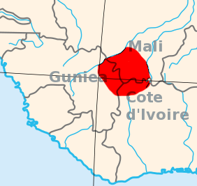
English: I created this, using the Gimp, and a blank area map from Wikpedia Commons, 2007-07-23. Area map of the Wassoulou (Wassulu, Wassalou, Ouassalou) region of Mali, Guinea (Guinee), Cote d'Ivoire: West Africa.
|
| Date | 2007-07-23 (original upload date) |
| Source | Transferred from en.wikipedia |
| Author | Original uploader was T L Miles at en.wikipedia |
| Permission ( Reusing this file) |
Released into the public domain (by the author). |
Licensing
 |
This work has been released into the public domain by its author, T L Miles at the wikipedia project. This applies worldwide. In case this is not legally possible: |
File usage
The following pages on Schools Wikipedia link to this image (list may be incomplete):
Learn more about Schools Wikipedia
SOS Children's Villages chose the best bits of Wikipedia to help you learn. By supporting vulnerable children right through to adulthood, SOS Children makes a lasting difference to the lives of thousands of people. Education is a key part of our work, and our schools provide high-quality teaching to the children in our care. If you'd like to help, why not learn how to sponsor a child?