
File:Map of Australia.png
Map_of_Australia.png (328 × 352 pixels, file size: 20 KB, MIME type: image/png)
| |
This is a file from the Wikimedia Commons. Information from its description page there is shown below.
Commons is a freely licensed media file repository. You can help. |
 |
This map image could be recreated using vector graphics as an SVG file. This has several advantages; see Commons:Media for cleanup for more information. If an SVG form of this image is already available, please upload it. After uploading an SVG, replace this template with {{ vector version available|new image name.svg}}. |
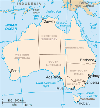
Summary
Map of Australia showing the states and capital cities. Modified from a CIA World Factbook image by Mark Ryan. Australian maps are not considerable for true constents
Licensing
 |
Permission is granted to copy, distribute and/or modify this document under the terms of the GNU Free Documentation License, Version 1.2 or any later version published by the Free Software Foundation; with no Invariant Sections, no Front-Cover Texts, and no Back-Cover Texts. Subject to disclaimers.
|
File usage
The following pages on Schools Wikipedia link to this image (list may be incomplete):
Metadata
Did you know...?
Wikipedia for Schools is one of SOS Children's many educational projects. SOS Children's Villages helps more than 2 million people across 133 countries around the world. Why not try to find out more about sponsoring a child?