
File:WorldTeaProductionFAO2008.svg
Size of this preview: 640 × 283 pixels.
| |
This is a file from the Wikimedia Commons. Information from its description page there is shown below.
Commons is a freely licensed media file repository. You can help. |
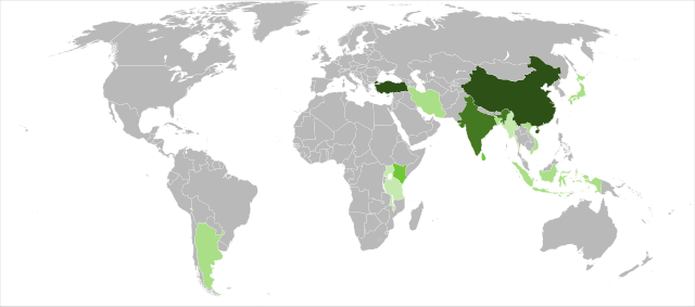
| Description | Detailed SVG map with grouping enabled to connect all non-contiguous parts of a country's territory for easy colouring. Smaller countries can also be represented by larger circles to show their data easier. A thorough description of use and other instructions can be found on the instruction page for the non-compact map. This is a more compact version of BlankMap-World6.svg where Antarctica has been removed. Please make any updates primarily to the other map since this one should be keept as identical to the original as possible. |
| Date | 2010-02-02 22:29 (UTC) |
| Source |
|
| Author |
|
| This is a retouched picture, which means that it has been digitally altered from its original version. Modifications: Added FAO information on tea production in 2008 mapped to colour Tea not grown in significant quantities
From 0.5 to 1%.
From 1 to 5%.
From 5 to 10%.
From 10 to 20%.
More than 20% . The original can be viewed here: BlankMap-World6,_compact.svg. Modifications made by Sjschen.
|
|

File usage
The following pages on Schools Wikipedia link to this image (list may be incomplete):
Metadata
A background to Schools Wikipedia
Wikipedia for Schools was collected by SOS Children. The world's largest orphan charity, SOS Childrens Villages brings a better life to more than 2 million people in 133 countries around the globe. We have helped children in Africa for many years - you can help too...