
File:Manaus-Amazon-NASA.jpg

Size of this preview: 480 × 480 pixels.
| |
This is a file from the Wikimedia Commons. Information from its description page there is shown below.
Commons is a freely licensed media file repository. You can help. |
Contents |
Descrption
Esperanto: La bildo estas kopiita de wikipedia:en. La originala priskribo estas:
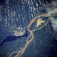
English: A satellite image of the city of Manaus with surrounding rivers.
English: Original caption:
- STS61C-33-84 Manaus, Amazonas, Brazil January 1986
- Two rivers and an urban area dominate this photograph. The largest city in the Amazon Basin, Manaus (with a 1994 population of 1.7 million), is located at the confluence of the Rio Negro (dark blue) and the Amazon River (lighter because of its high sediment content). The combined river flows eastward into the Atlantic Ocean. Situated approximately 800 miles (1290 kilometers) from the mouth of the Amazon River but accessible to oceangoing ships, Manaus is an important river port. This port city started to flourish in the late 1800s when the rubber boom was at its peak. Rubber, Brazil nuts, lumber, and assorted fruits are exported. In recent years, renewed interest in general development and the discovery of oil and manganese near Manaus have brought new importance to the city. A number of highways (linear, light-colored features), as well as a large commercial airport north of the city, are visible in the rain forest north and south of Manaus. North-south ground transportation is hindered because no bridges cross the Rio Negro or Amazon River. A large, sediment-laden lake (note irregular shoreline) is located east of Manaus between the main channel of the Amazon River and a smaller channel to the south.
Source
http://earth.jsc.nasa.gov/sseop/EFS/photoinfo.pl?PHOTO=STS61C-33-84 ( file)
English: Photo credit: NASA
| This image or video was catalogued by one of the centers of the United States National Aeronautics and Space Administration (NASA) under Photo ID: STS61C-33-84. This tag does not indicate the copyright status of the attached work. A normal copyright tag is still required. See Commons:Licensing for more information. |
English-Wikipedia:
| date/time | username | edit summary |
|---|---|---|
| 10:52, 14 December 2004 | en:User:Magnus Manske | ({{PD-USGov-NASA}}) |
| 18:15, 18 June 2004 | en:User:Sverdrup | (Image info) |
| 18:14, 18 June 2004 | en:User:Sverdrup | (A satellite image of the city of Manaus with surrounding rivers.) |
Other version: Image:Manaus-Amazon-NASA2.jpg
See also
License
 |
This file is in the public domain because it was solely created by NASA. NASA copyright policy states that "NASA material is not protected by copyright unless noted". (See Template:PD-USGov, NASA copyright policy page or JPL Image Use Policy.) |
 |
 |
Warnings:
|
File usage
The following pages on Schools Wikipedia link to this image (list may be incomplete):
Metadata
A background to Schools Wikipedia
You can learn about nearly 6,000 different topics on Schools Wikipedia. In 133 nations around the world, SOS Childrens Villages works to bring better education and healthcare to families in desperate need of support. Why not try to learn more about child sponsorship?