
File:Anjouan (Comoros) map.jpg
Anjouan_(Comoros)_map.jpg (350 × 382 pixels, file size: 23 KB, MIME type: image/jpeg)
| |
This is a file from the Wikimedia Commons. Information from its description page there is shown below.
Commons is a freely licensed media file repository. You can help. |
Summary
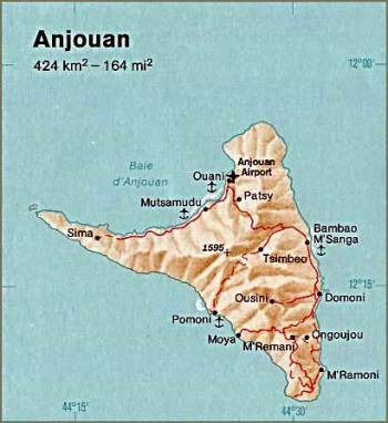
| Description | Anjouan. From The Indian Ocean Atlas, CIA, 1976. | ||
| Date | 1976 | ||
| Source | University of Texas Libraries, Perry-Castañeda Library Map Collection: Comoros Maps
|
||
| Author | CIA |
Licensing
 |
This image is a work of a Central Intelligence Agency employee, taken or made as part of that person's official duties. As a Work of the United States Government, this image or media is in the public domain.
|
 |
File usage
The following pages on Schools Wikipedia link to this image (list may be incomplete):
I want to learn more...
Wikipedia for Schools is designed to make learning fun and easy. SOS Children's Villages helps those who have nothing and no one, giving them back the famly they have lost and bringing them the very best opportunities for a happy, healthy future. If you'd like to help, why not learn how to sponsor a child?