
File:Chartres - cathédrale - rosace nord.jpg
Size of this preview: 346 × 479 pixels.
| |
This is a file from the Wikimedia Commons. Information from its description page there is shown below.
Commons is a freely licensed media file repository. You can help. |
|
Summary
| Description |
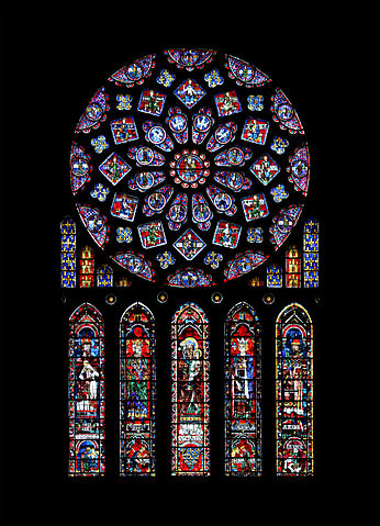
English: Northern rose window of Chartres cathedral. The rose depicts the Glorification of the Virgin Mary, surrounded by angels, twelve kings of Juda (David, Solomon, Abijam, Jehoshaphat, Uzziah, Ahaz, Manasseh, Hezechiah, Jehoiakim, Jehoram, Asa et Rehoboam) and the twelve lesser prophets (Hosea, Amos, Jonah, Nahum, Zephaniah, Zechariah, Malachi, Haggai, Habakkuk, Micah, Obadiah and Joel). Below, the arms of France and Castile (the window was offered by Blanche of Castile). The five lancets represent Saint anne, mother of the Virgin, surrounded by the kings Melchizedek, David, Solomon and by Aaron, treading the sinner and idolatrous kings: Nebuchadnezzar, Saul, Jeroboam and Pharaoh.
Français : Rosace nord de la Cathédrale Notre-Dame de Chartres. La rosace dépeint la Glorification de la Vierge, entourée des anges, de douze rois de Juda (David, Salomon, Abijam (Abia), Josaphat (Iosapht), Azarias (Ozias), Achaz (Acaz), Manassé (Mahases), Ézéchias, Joachim (Ioatam), Joram (Ioram), Asa et Roboam) et des douze petits prophètes (Osée (Oseas), Amos, Jonas, Nahum (Naum), Sophonie (Sephonias), Zacharie, Malachie (Malacias), Aggée (Ageus), Habacuc (Abbacuc), Michée (Micheas), Abdias et Joël (Iohel)). En-dessous, les armes de France et de Castille (la rosace a été offerte par Blanche de Castille). Les cinq lancettes représentent Sainte Anne, mère de la Vierge, entourée des rois Melchisedech, David, Salomon et d'Aaron, foulant les rois pécheurs et idolâtres : Nabuchodonosor, Saül, Jéroboam et Pharaon.
|
|
| Date | 7 February 2009 | |
| Source | Own work | |
| Author |
|
|
Camera location |
|
This and other images at their locations on: Google Maps - Google Earth - OpenStreetMap | ( Info) |
|---|
| This is a retouched picture, which means that it has been digitally altered from its original version. Modifications: montage from two pictures, geometry corrected, levels adjusted, sharpened.
|
Licensing
 |
I, the copyright holder of this work, release this work into the public domain. This applies worldwide. In some countries this may not be legally possible; if so: I grant anyone the right to use this work for any purpose, without any conditions, unless such conditions are required by law.
|
| Annotations | This image is annotated: View the annotations at Commons |
File usage
The following pages on Schools Wikipedia link to this image (list may be incomplete):
Metadata
More information
SOS Children's Villages aims to make Wikipedia suitable for young learners. By supporting vulnerable children right through to adulthood, SOS Children makes a lasting difference to the lives of thousands of people. Education is a key part of our work, and our schools provide high-quality teaching to the children in our care. You can help by sponsoring a child.