Grafika:British Empire Anachronous 7.png
Z Wikipedii
Rozmiar podglądu: 800 × 370 pikseli
Obraz w wyższej rozdzielczości (1 357 × 628 pikseli, rozmiar pliku: 55 kB, typ MIME: image/png)
| | Plik British Empire Anachronous 7.png [ edytuj opis ] umieszczony jest w Wikimedia Commons, repozytorium wolnych zasobów projektów Fundacji Wikimedia. Wyjaśnienie podanej poniżej licencji znajdziesz na stronie Opisy licencji grafiki. |
| Description |
English:
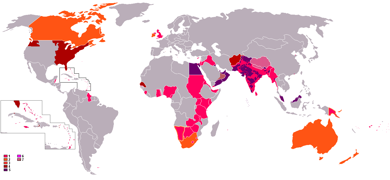
: An anachronous map of the British Empire (showing its many forms of control). The colours in the map key are explained according to their related numbers as follows:
中文:
: 时间交错的大英帝国全球地图。地图上的各种颜色的意义说明如下:
|
|---|---|
| Source |
Originally from en.wikipedia; description page is/was here. |
| Date |
2006-10-08 (original upload date) |
| Author |
Original uploader was Gsd2000 at en.wikipedia |
| Permission (Reusing this image) |
Released under the GNU Free Documentation License. |
[edit] License information

 |
This map image should be recreated using vector graphics as an SVG file. This has several advantages; see Commons:Media for cleanup for more information. If an SVG form of this image is already available, please upload it. After uploading an SVG, replace this template with template {{Vector version available|new image name.svg}} in this image. |
|
العربية | Български | Català | Česky | Dansk | Deutsch | English | Esperanto | Español | Français | Galego | 한국어 | Italiano | Magyar | Lietuvių | Nederlands | 日本語 | Polski | Português | Română | Русский | Suomi | Svenska | Türkçe | Українська | Tiếng Việt | मराठी | 中文(繁體) | 中文(简体) | +/- |
|
[edit] Original upload log
(All user names refer to en.wikipedia)
- 2006-10-08 13:08 Gsd2000 1357×628×8 (42019 bytes)
Historia pliku
Kliknij na datę/czas, aby zobaczyć, jak plik wyglądał w tym czasie.
| Data/czas | Wymiary | Użytkownik | Opis | |
|---|---|---|---|---|
| aktualny | 15:01, 18 kwi 2008 | 1 357×628 (55 kB) | LaGrandefr | ({{Information |Description= {{en}}: An anachronous map of the British Empire (showing its many forms of control). The colours in the map key are explained according to their related numbers as follows: *1.Pink: colonies held by 1945 *2.Orange:Dominions ) |
| 22:37, 20 wrz 2007 | 1 357×628 (41 kB) | Tarret | ({{Information |Description=An anachronous map of the British Empire (showing its many forms of control). The colours in the map key are explained according to their related numbers as follows: *1.Pink: colonies held by 1945 *2.Orange:Dominions *3.Pink in) |
Odnośniki do pliku
Następujące strony odwołują się do tego pliku:

