Grafika:Quiberon on nasa map.jpg
Z Wikipedii
Grafika w wyższej rozdzielczości jest niedostępna.
Quiberon_on_nasa_map.jpg (267 × 314 pikseli, rozmiar pliku: 22 kB, typ MIME: image/jpeg)
| | Plik Quiberon on nasa map.jpg [ edytuj opis ] umieszczony jest w Wikimedia Commons, repozytorium wolnych zasobów projektów Fundacji Wikimedia. Wyjaśnienie podanej poniżej licencji znajdziesz na stronie Opisy licencji grafiki. |
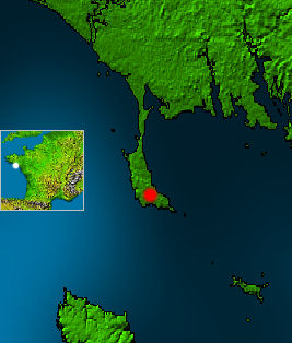
White point on mini map marks, which part of France is shown. Red point marks the city w:Quiberon on the peninsula of Quiberon. In the east of the peninsula there is the bay of Quiberon. In the south you see a part of w:Belle Île.
- This map is based on a NASA work, which is considered to be public domain (see box below), source: http://photojournal.jpl.nasa.gov/catalog/PIA03393
- Edits by Matthäus Wander are licensed unter GFDL, see box

| This image uses high-resolution digital topography data from NASA's Shuttle Radar Topography Mission (SRTM) at JPL-Caltech. It is in the public domain |
|
Historia pliku
Kliknij na datę/czas, aby zobaczyć, jak plik wyglądał w tym czasie.
| Data/czas | Wymiary | Użytkownik | Opis | |
|---|---|---|---|---|
| aktualny | 21:21, 18 kwi 2005 | 267×314 (22 kB) | Matthäus Wander | (White point on mini map marks, which part of France is shown. Red point marks the city w:Quiberon on the peninsula of Quiberon. In the east of the peninsula there is the bay of Quiberon. In the south you see a part of w:Belle Île. * This map) |
Odnośniki do pliku
Następujące strony odwołują się do tego pliku:

